East Thuringian-Vogtland plateaus
The East Thuringian-Vogtland plateaus are a natural sub-unit of the Thuringian Slate Mountains . The name East Thuringian Slate Mountains is also common . The part of the plateau to the west and two parts to the east of the Saale form a landscape in the Thuringian Slate Mountains-Obere Saale Nature Park .
landscape
The east -Thuringian-Vogtland plateaus , located almost exclusively in Thuringia (mainly Saale-Orla district and Greiz district ), represent the north-western part of the natural Vogtland . They extend from the Ronneburg arable and mining area east of Geras along the south-eastern edge of the Thuringian basin to the southwest to the trunk of the Thuringian Slate Mountains between Saalfeld and Blankenstein . In addition to the districts mentioned, the plateaus in the extreme west also have a share in the Saalfeld-Rudolstadt district , also Thuringia, and in the east in the extreme west of the Vogtland district , Saxony . While the landscape in the handbook of the natural spatial structure of Germany is assigned to the natural spatial Vogtland, a buffer unit between the Hercynian Thuringian-Franconian low mountain range and the Variscan Ore Mountains , in the GDR structures it was mostly understood as part of the Thuringian Slate Mountains.
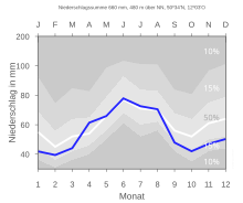
Wavy plateaus, mainly used for agriculture, offer impressive panoramic views, the specialty of this high and open landscape. Particularly characteristic features of the landscape in the east of the slate mountains are the diabase domes , such as the Pöhlde or the Hübel, with their forests. They consist of volcanic rocks, diabases, which are harder than the surrounding rock and therefore weather more slowly, creating the typical peaks. The flat valleys and the large clearing islands around the villages are also typical of the area. Compared to the High Thuringian Slate Mountains, the climate is less harsh. The meteorological values are more like the average for Thuringia.
The brown hare is found mainly in open terrain , on wide meadows and fields, which it finds widespread in the Oberland. The stock of brown hares is declining due to intensive land management. Beautiful old avenues are characteristic of this natural area . The Deutsche Alleenstraße also runs through this landscape coming from Ziegenrück via Bad Lobenstein in the direction of Vogtland. Bats, such as the great mouse-eared mouse , use abandoned tunnels as wintering quarters, as the temperatures here are uniform. In summer they live in attics, barns or churches and can be seen all over the area.
Typical of the cultural landscape are old clearing villages around the modest Reussian residences Greiz , Schleiz and Lobenstein.
Location and limits
Immediately north of Greiz is the interface between the East Thuringian-Vogtland plateau in the narrower sense in the west, its northern extension of the Ronneburg arable and mining area in the north (east) and the Central Vogtland hill country as the central part of the natural Vogtland in the south.
From here the border between the plateaus and the hilltop land runs in a south-westerly direction across the west of Plauen and the extreme west of the Vogtlandkreis , to accompany the Saale valley from Hirschberg to the mouth of the Selbitz near Blankenstein . Beyond the Saale, smaller areas in the far north of the district of Hof are also part of the natural area.
From the Selbitz estuary, in turn, the border between the East Thuringian-Vogtland plateau and the Franconian Forest and the Schwarza-Sormitz area - both parts of the Thuringian Slate Mountains - stretches north-west to south of Saalfeld , where the Saale valley is reached again.
From Saalfeld, the north-western border of the plateaus extends along the Orlasenke to Triptis and further along the southeast of the Saale-Elster sandstone slab to Gera - both of the last-mentioned natural areas are main units of the Thuringian basin (with edge slabs) .
The valley of the White Elster from Gera upstream to the southeast via Wünschendorf and Berga to north of Greiz forms the (still within) northeast border to the Ronneburg arable and mining area.
Natural structure
The natural spatial main unit is assigned as follows according to the manual of the natural spatial structure of Germany and, in addition to its heartland, contains the sub-natural areas listed below:
-
to 41 Vogtland (1884 km² according to the manual)
-
410 East Thuringian-Vogtland plateaus
- Ronneburg arable and mining area (190 km² according to BfN )
- Plothener Teichplatte (83 km² according to TLUG)
- Upper Saale Valley between Hirschberg and Saalfeld (a total of 263 km² within Thuringia according to TLUG)
-
410 East Thuringian-Vogtland plateaus
East Thuringian Slate Mountains – Vogtland
In the Thuringian natural areas of the Thuringian State Institute for Environment and Geology (TLUG), which deviates from the manual, the East Thuringian Slate Mountains – Vogtland unit, which covers 1148 km², mainly refers to the local main unit minus the sub-natural areas listed above. The small marginal parts of the Mittelvogtland hilltop land (especially near Greiz ) are "incorporated" and the entire landscape is added to the Thuringian Mountains , which also includes the Thuringian Forest , the actual Thuringian Slate Mountains and the Thuringian fringe parts of the Franconian Forest .
Individual evidence
- ^ E. Meynen and J. Schmithüsen : Handbook of the natural spatial structure of Germany - Federal Institute for Regional Studies, Remagen / Bad Godesberg 1953–1962 (9 deliveries in 8 books, updated map 1: 1,000,000 with main units 1960)
-
^ Walter Hiekel, Frank Fritzlar, Andreas Nöllert and Werner Westhus: The natural spaces of Thuringia . Ed .: Thuringian State Institute for Environment and Geology (TLUG), Thuringian Ministry for Agriculture, Nature Conservation and Environment . 2004, ISSN 0863-2448 . → Natural area map of Thuringia (TLUG) - PDF; 260 kB → Maps by district (TLUG)
