
Saalfeld / Saale
| coat of arms | Germany map | |
|---|---|---|

|
Coordinates: 50 ° 39 ' N , 11 ° 21' E |
|
| Basic data | ||
| State : | Thuringia | |
| County : | Saalfeld-Rudolstadt | |
| Height : | 235 m above sea level NHN | |
| Area : | 145.56 km 2 | |
| Residents: | 29,278 (Dec. 31, 2019) | |
| Population density : | 201 inhabitants per km 2 | |
| Postal code : | 07318 | |
| Area code : | 03671 | |
| License plate : | SLF, RU | |
| Community key : | 16 0 73 077 | |
| LOCODE : | DE SAD | |
| City structure: | 14 districts | |
City administration address : |
Markt 1 07318 Saalfeld / Saale |
|
| Website : | ||
| Mayor : | Steffen Kania ( CDU ) | |
| Location of the district town of Saalfeld / Saale in the district of Saalfeld-Rudolstadt | ||
  |
||


Saalfeld / Saale is a city in Thuringia . It is the district town of the Saalfeld-Rudolstadt district in the south-east of the state and is located in an approximately 250 km² area with 75,000 inhabitants, which also includes the cities of Rudolstadt and Bad Blankenburg . The three cities cooperate with each other within the framework of the “Saalebogen city triangle”. Saalfeld is located on the Saale in the middle of the Saale arch. The Thuringian Slate Mountains begin southwest of the city . The most famous attractions are the fairy grottoes . The city is also a major rail hub. Saalfeld is classified as a middle center with partial functions of an upper center . Together with Rudolstadt and Bad Blankenburg, it forms a tripolar center .
geography
Saalfeld lies in the valley of the Saale , which once gave the city its name, at an altitude of about 235 meters. The Thuringian Slate Mountains begin southwest of the city with mountains over 500 meters high on the outskirts. To the south lies the valley of the Saale and its tributaries Loquitz and Sormitz . These valleys are deep, narrow valleys that are very scenic. In addition, the " Saalekaskade " dam system is located in the southeast of the city , which extends along the Saale to Bad Lobenstein and includes the largest dams in Thuringia and two of the largest in Germany, the Bleilochtalsperre and the Hohenwarte dam. The Orlasenke begins to the east of the city , a fertile, wide valley depression that extends to the city of Triptis , 35 kilometers to the east . To the north of Saalfeld the Vordere Heide, the most south-westerly foothills of the Thuringian woodland with the 481 meter high Kulm , the city's local mountain, on which there is a steel lattice tower from which one can see the entire surrounding area. The red sandstone deposits begin near Saalfeld and stretch north to Rothenstein. The Saale leaves the city to the northwest; there are also the neighboring cities of Rudolstadt and Bad Blankenburg, the beginning of the Schwarza Valley .
The city itself is located on the western, the mountain bank of the Saale. The old town is located on a hill not far from the river. It is surrounded by other residential areas, while industrial and commercial areas dominate on the eastern side of the Saale around the Saalfeld train station . The district of Gorndorf with the city's prefabricated building area is also located here. While this prefabricated housing estate was considered an unattractive and social hotspot after the fall of the Wall , Saalfeld has managed to significantly upgrade this district with its own urban development concept.

climate
The annual precipitation is 528 mm. This value belongs to the lower tenth of the values recorded in Germany. The driest month is January, the most precipitation falls in August. The rainfall varies greatly.
Neighboring communities
Neighboring communities are Rudolstadt , Unterwellenborn , Kaulsdorf , Probstzella , Graefenthal , Neuhaus am Rennweg , Rohrbach , Döschnitz , Schwarzburg and Bad Blankenburg .
City structure
The following districts belong to Saalfeld, with district numbers according to the main statute:
|
history
Founded until 1800
_307.jpg)
Saalfeld was first mentioned in a document in 899 and is one of the oldest foundations in East Thuringia. There was a Carolingian royal palace here , the chapel of which is the church of the Graba district. The later Emperor Heinrich II gave the area around Saalfeld in 1012 to the Count Palatine Ezzo of Lorraine , whose daughter Richeza gave it to the Archdiocese of Cologne in 1056 . When in 1071 (other information: 1074) the Archbishop of Cologne , Anno II. Founded the Benedictine monastery of St. Peter and Paul here , the place quickly developed into the ecclesiastical center of power in eastern Thuringia. The monastery led the Christianization and settlement of the area. The historian Lampert von Hersfeld , who stayed in the Saalfeld monastery for several weeks, reports on the founding of the monastery . For many years his chronicles are the only written sources on regional history. The monastery existed until after the Reformation (until 1526).
After it came back into imperial possession, Saalfeld received city rights in 1208 as the fourth place in Thuringia . At the same time, Emperor Friedrich Barbarossa commissioned the construction of an urban settlement to be built south of the old village (Altsaalfeld) . The town charter was confirmed in 1208 by the Schwarzburgers , who were the feudal lords of the Saalfeld area at the time. The city wall was erected in 1363, there was a first town hall in 1389, and the first Saale bridge is mentioned in 1373. Around 1250, a Franciscan monastery was added to the Benedictine monastery , which existed until 1534. It was located in what is now the city museum. From 1258 onwards, the Saale rafting and from the late 13th century mining are known as branches of the economy. In 1346 the city finally got the right to fish in the Saale, which the barbel in the city coat of arms still stands for today . Another right was added in 1482, when the Saalfelder received high jurisdiction over neck and hand. An economic boom set in. In 1389, Saalfeld passed from the Schwarzburgers to the Wettins , who owned it until the abolition of the monarchy in 1918. During the partition of Erfurt in 1572, Saalfeld came to Saxe-Weimar , 1603 to Saxe-Altenburg and 1673 to Saxe-Gotha .


In 1514, after almost 150 years of construction , the Johanneskirche was completed. However, a city fire destroyed large parts of Saalfeld as early as 1517. During the subsequent reconstruction, the city received its present-day image , which is characterized by Renaissance buildings . Among other things, today's town hall (1529 to 1537), the mint (1551) as well as many town houses and a little later also the city pharmacy (1617 to 1620) were built.
Duke Albrecht made Saalfeld his residence in 1675 and began building Schloss Saalfeld in 1677 , which was then taken over by his younger brother Johann Ernst in 1680 and completed by 1726. It was created on the area of the former Benedictine monastery, which was demolished for this purpose. The necessity of a residential palace arose from the prospect of an inheritance division of the Ernestines from 1675 and finally carried out in 1680 , during which the Duchy of Saxony-Saalfeld was created, which only existed until 1745 and then became the property of Saxony-Coburg (then as Saxony-Coburg -Saalfeld designated) passed. After the line Saxe-Gotha and Altenburg died out in 1825, Saxe-Gotha came to Saxe-Coburg-Saalfeld (therefore renamed Saxe-Coburg and Gotha ), which gave Saalfeld and most of Saxe-Hildburghausen to Saxe-Meiningen . Friedrich von Sachsen-Hildburghausen became Duke of the re-founded Sachsen-Altenburg.
1800 until today
On October 10, 1806, the battle took place near Saalfeld , which ended with a victory for 14,000 French soldiers over a 9,000-strong Prussian army and in which the Prussian Prince Louis Ferdinand was killed. In the 19th century, industrialization began in Saalfeld, which took its greatest boom after the opening of the Leipzig – Gera – Saalfeld railway in 1871. In the decades that followed, Saalfeld developed into an important railway junction between Leipzig and Nuremberg, with further connections to Hof and Gera in the east, Jena in the north, Nuremberg in the south and Erfurt and Sonneberg in the west. Local railway lines also led via Rottenbach to Königsee and Katzhütte . The steep Frankenwald Railway was electrified for the first time in 1939 , before the Soviet Union had the contact wire removed as reparations in 1945, as was the case with the Saalbahn . The renewed electrification of the line between Probstzella and Camburg did not take place until 1995 after German reunification . During industrialization, the Saalfeld mining industry, which had been in operation since the Middle Ages, developed into the Maxhütte Unterwellenborn , a branch of the Upper Palatinate Maxhütte founded in 1872 . The rafting of the Saale, which had also been in operation since the Middle Ages, was only stopped in 1938 after the Saale Cascade was built.
In 1914 the fairy caves were made accessible to the public after they had been discovered in old mine tunnels in 1910. After the First World War , the monarchies were abolished and the new Free State of Thuringia was founded. Saalfeld now became the district town of the Saalfeld district , which existed until 1994. Before that, the city had been the administrative seat of the Saalfeld district in the Duchy of Saxony-Meiningen since 1868 , which, however, had a much different regional layout than its successor.
During the time of National Socialism , people were subjected to persecution for racist , political and religious reasons, which began in 1933 when they were brought to the local court prison, popularly known as hat boxes . People were also persecuted for eugenic reasons, such as the 571 people who were made victims of forced sterilization by the Hereditary Health Court . The Jewish citizens of Saalfeld were forced to emigrate and from 1941 were put to death in ghettos or extermination camps.
As early as 1939, Jews were used as part of the closed labor deployment in the construction of the Hohenwarte dam and housed in a camp near Saalfeld. During the Second World War , 1,491 prisoners of war as well as women and men from the countries occupied by Germany, mainly from the Soviet Union , had to do forced labor : at Optische Anstalt 99 , SAG 99 , Mecano-Werke , Mitteldeutsche Elektro , company Max Schaede in company Auerbach & disc in the consortium Saale dam in Hohenwarte in company & Paschold, Döğer Co. , the chocolate factory Mauxion , at the company Adolf Knoch , at the company Paul Eberlein sons in company Gustav Bodenstein and in Reichsbahn . A Soviet memorial with 68 tombstones and three memorial plaques was built in the cemetery in 1947. To commemorate the victims of the Buchenwald concentration camp death march in April 1945, a stele was erected in 1985 at the Schloßstraße / Auf dem Graben intersection. In 2008, 10 stumbling blocks for Jewish victims of National Socialism were laid in Saalfeld.
From 1936 to 1945 Saalfeld was the location of the Wehrmacht (the Prinz-Louis-Ferdinand-Kaserne was outside the city area, in the municipality of Beulwitz ).
→ Main article: Air raids on Saalfeld
The city was badly damaged in bombing towards the end of the Second World War, the main focus of the attack was the extensive railway facilities. In an American air raid on Monday, April 9, 1945, at least 208 people died in the hail of bombs and gunfire from the 52 missions (around eight waves with six to seven aircraft each) that started shortly before 9 a.m. and lasted until 7 p.m. The victims were mostly women and children, military personnel, wounded from a hospital train standing in the station and railway personnel. There were also countless seriously injured people. Surveys by the city administration show that in Saalfeld 22 houses were completely destroyed, 146 apartments were bombed and 573 were damaged by this attack. Damage of 7.5 million Reichsmarks was caused by more than 1,300 bombs with an explosive force of 500 to 1,000 pounds as well as the fires. The train station, an important traffic junction, and the industrial area (Altsaalfeld) near the train station were heavily bombed. An air raid at around 8:20 a.m. also brought production in the Maxhütte to a standstill because the energy supply center was hit hard. Even monuments of the old town were affected: the St. John's Church, the Franciscan monastery (the city museum), the Saalfeld Castle, the castle Kitzerstein that Saaltor and City Hall.
On April 12, US troops stood on the outskirts, and on April 13, in the morning, Saalfeld was handed over to the Americans by the incumbent mayor. Before that - on April 12th and 13th - all bridges across the Saale in and around the city had been blown up by the Wehrmacht. 819 inhabitants of Saalfeld were killed in World War II.
Like all of Thuringia, Saalfeld was handed over by the Americans to the Red Army at the beginning of July 1945 and thus part of the Soviet occupation zone , and from 1949 of the GDR .
On August 16, 1951, a large number of angry Bismut miners stormed the city's prison and police station, demanding the release of imprisoned pals. The background to this was the dissatisfaction with the poor social conditions that the rapid influx of many miners brought with it to promote uranium ore mining for the Soviet nuclear weapons program. In May 1952 the Thuringian state court sentenced twelve alleged ringleaders to eight to 15 years in prison. The mining of uranium ore in the area around Saalfeld turned out to be unprofitable and has been discontinued.
In 1994 the districts of Saalfeld and Rudolstadt , which were established in 1952, were merged to form the district of Saalfeld-Rudolstadt , the district of which became Saalfeld. In 1999 the Thuringian Day took place in Saalfeld.
Incorporations
On July 1, 1950, the previously independent communities of Obernitz and Remschütz were incorporated. Gorndorf followed on January 1, 1963. Beulwitz on April 6, 1994 and Arnsgereuth on December 1, 2011. On July 6, 2018, Saalfelder Höhe and Wittgendorf were added, and on January 1, 2019, Reichmannsdorf and Schmiedefeld.
Population development
Development of the population (from 1960 December 31) :
.svg)
|
1833 to 1950
|
1960 to 1997
|
1998 to 2006
|
2007 to 2015
|
from 2016
|
- Data source from 1994: Thuringian State Office for Statistics
politics
City council
The city council election on May 26, 2019 resulted in the following distribution of seats with a turnout of 56.2%:
| Political party | Seats | +/- |
|---|---|---|
| CDU | 10 | ± 0 |
| AfD | 5 | +5 |
| SPD | 4th | ± 0 |
| LEFT | 4th | −3 |
| FDP | 3 | ± 0 |
| Alliance 90 / The Greens | 3 | +1 |
| The young | 2 | ± 0 |
| FWSH | 1 | −1 |
| total | 32 | +2 |
mayor

Mayor is Steffen Kania (CDU). In the mayor election on April 15, 2018, 43.5% of the votes cast went to the current mayor. Steffen Lutz (SPD) reached 32.3%, Oliver Brömel (non-party) 14.0%, Sebastian Sussek (non-party) 7.9% and Roland Beyer (non-party) 2.2%. In the runoff election on April 29, 2018, Kania won against its competitor Lutz with 52%. The turnout was 45.3% in the first ballot and 37.9% in the runoff election.
coat of arms
Blazon : "In green, two erect, averted silver barbels, accompanied by two hexagonal silver stars."
The place got its name from the location on the Saale, which is why fish predominate in the coat of arms. When choosing the colors, the green-silver national colors of the Saxon duchies in Thuringia were important. Saalfeld belonged to Sachsen-Meiningen until 1918 and in 1921 established the coat of arms through a local law according to the rule that was then common in the new Free State of Thuringia.
Town twinning
Saalfeld maintains town partnerships with:
- Stains ( France ) since 1964
- Sokolov (Falkenau an der Eger) ( Czech Republic ) since 1974
- Kulmbach ( Bavaria ) since 1988
- Samaipata ( Bolivia ) since 1996
- Zalewo (Saalfeld) ( Poland ) since 2001
On the edge: In Lünen an der Lippe, after the Second World War, a settlement (part-time jobs) for people displaced and refugees named 'Saalfeld' was built in reminiscence of Saalfeld.
City triangle Saalebogen
The cities of Saalfeld / Saale, Rudolstadt and Bad Blankenburg have been working together since 1997 as the city triangle on the Saalebogen . A public discussion about a possible permanent amalgamation of the three cities into a new large city quickly petered out. At the administrative level, however, sensible possible partial cooperations are discussed further. One result is u. a. the amalgamation of the city's business development offices to form a regional business development agency in July 2007. The establishment of a higher-quality educational institution is also planned. Various properties were presented to the Ministry of Science as a location for a university of applied sciences or vocational academy.
Culture and sights
.jpg)
Buildings
"Hutschachtel" official prison
The tower-like rotunda was built as a prison according to the plans of the Meiningen master builder Carl Rudolf Tröger from 1857 to 1859 and cost 14,500 guilders. On November 25, 1859, it was handed over to the Duchy of Saxony-Meiningen as an official prison . Until 1950 it was still used as a prison by the National Socialists and later by the Soviet military administration. In 1973 the city of Saalfeld took over the building and used it as a city archive after the renovation .
Other structures


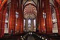
- The largest church in the city and one of the largest hall churches in Thuringia is the Gothic Johanneskirche , the Protestant town church in Saalfeld.
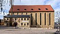
- The Thuringian Museum of Local History is located in the west of the old town in the former Franciscan monastery. It dates from the period between 1490 and 1520 and is built in the Renaissance style. After its abolition in the course of the Reformation (1534) it became a municipal Latin school (until 1914), and from 1904 it was also used as a museum, which continues to this day. Attached is the monastery church from 1293 and 1513, which was given a baroque flat ceiling in 1729.
- The Catholic Church also has its own church in Saalfeld. Your Corpus Christi Church was built in the neo-Romanesque style in 1905/06 and today still largely has the original furnishings from the construction period.
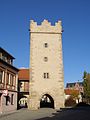
- The city fortifications were first mentioned in a document in 1363. Most of the wall is preserved, the four gates have been completely preserved. The wall was partially razed from 1832. The Blankenburger Tor is the northern exit of the old town and its baroque version dates from 1739. The Darrtor towards the castle is now accessible as a viewing tower and is older than the Blankenburger Tor. The hall gate to the east towards the Saale bridge is similar in design to the Darrtor. The Upper Gate from 1738 forms the southern entrance to the old town.
- The castle is now the district office and came after it was demolished in 1676, the Benedictine monastery. It was built by Christian Wilhelm Gundermann between 1677 and 1679 and was the residence of Sachsen-Saalfeld between 1680 and 1745 . The associated castle chapel was built from 1704 and was consecrated in 1720.
- Wetzelstein Castle , a neo-Romanesque building from 1878 to 1880, once owned by the chocolate manufacturer Hüther
- The Hohe Schwarm , the ruin of a castle from around 1300, looms over the steep bank of the Saale on the eastern edge of the old town. At that time it was built by the Counts of Schwarzburg to control the city and the Saale valley.
- Not far from the castle ruins is the Kitzerstein Castle from 1435. Today the music school is housed there.
- The town hall on the market square was built after the city fire of 1517 between 1529 and 1537 and is considered one of the most important Renaissance town halls in Thuringia.
- The former St. Nikolai Church (Saalfeld / Saale)
- The Gothic St. Martin's Chapel is the oldest building in the city.
Other attractions are
- the city pharmacy , a Renaissance building from 1618/20,
- the market pharmacy , owned by the Arndt family until 1992, in a massive residential tower from 1468,
- the patrician house on Saalstrasse
- the Gertrudiskirche in the Graba district, part of the Saalfeld Königspfalz.

market

Upper street

Johanneskirche
Johanneskirche
Former Franciscan monastery

Brudergasse 17

Hiltmann's house

The hole
Drying gate

Upper gate


Natural monuments

The most important sights are the fairy grottoes , a former alum slate mine , in which nature has created a fascinating marvel of stalactites and multi-colored minerals. The colors and reflections are particularly effective thanks to the subsequent installation of small water basins in the grotto. In the Guinness Book of World Records , they are noted as "the most colorful show caves in the world." The fairy grottoes are also one of the oldest caves in the world that are open to tourists. Guided tours took place here even before the First World War.
In the district of the incorporated district of Obernitz , the Gleitsch protrudes as a pointed spur from the north into the Saale valley and thus changes the course of the Saale to a sharp bend to the south, then west and north. The mountain forms a striking natural point there. There is also the Devil's Bridge with a cave opening to the south. Paleolithic stone drawings were also found here. In addition, finds from the later Bronze Age and the pre-Roman Iron Age were recovered. A rampart with a sacrificial site was located on the summit above this settlement area.
The slope of this mountain towards the Saale forms a 600 meter long and about 120 meter high rock wall, the so-called plank wall . Due to the geological peculiarities of this rock face, on which numerous tectonic , stratigraphic and paleontological peculiarities are visible, the plank wall was added to the list of national geotopes in 2006.
Sports
There is the Saalfeld Athletics Club, which is successful at the state level, the soccer clubs FC Saalfeld and TSG "Bau" Remschütz and, since 2011, the 1st Women's Soccer Club Saalfeld, the sports clubs 1st SSV Saalfeld and MTV 1876 Saalfeld, Saalfeld swimming club, with the Saalfeld Titans an American Football club, the shooting society Saalfeld a. P. 1446 e. V., in the field of martial arts the Judo-Sport Club Saalfeld e. V. (1990) and Budokan Saalfeld e. V. (1996) as well as many other smaller sports clubs.
In 2014, a new football club, FC Saalfeld eV, was founded, which takes up the traditional lines of FC Lok Saalfeld and VFL 06 Saalfeld.
Easter egg tree
An Easter egg tree decorated with 10,000 eggs reaches media attention every year . From 1965 to 2015 it stood on the Kraft family's property. In 2016 the tree was in the city park in front of the district office.

In 2017, a tree in the pedestrian zone in Blankenburger Strasse was selected for this.
music
Choral music
Church music has a long tradition at the Johanneskirche in Saalfeld . Cantor Wilhelm Köhler (1852–1924) laid the foundations on which Walter Schönheit (1927–1985) built and founded the Oratorio Choir Saalfeld on February 28, 1950, the Thuringian Boys' Choir on March 22, 1950 and the Saalfeld Girls Choir on March 25, 1950 March 1950 provided regular church music based on the model of Johann Sebastian Bach. Under this slogan he put the entire choir work at the same time: Soli Deo Gloria - Alone for the glory of God. With the help of these three choirs it was now possible to perform all church music pieces of the present and past.
After Walter Schönheit's early death, his son Michael Schönheit took over the direction of all three choirs from 1985 to 1991. He was followed by church music director Wolfram Otto from 1991 to 2001 and Dietrich Modersohn from 2003 to 2011. Andreas Marquardt, himself a former Thuringian choir boy, cantor and organist at the Johanneskirche in Saalfeld, has been entrusted with the direction of the choirs since January 2013.
From the ranks of the former Thuringian Boys' Choir, ensembles have repeatedly formed that perform in local, national and international areas. Including the men's double quartet Die Saalfelder Vocalisten, which can already look back on concert tours through South Africa and Japan, but also numerous appearances in German-speaking countries.
In addition to the church music at the Johanneskirche in Saalfeld, there are also choirs at other churches and chapels in the Saalfeld area. This is also the case with the chamber choir of the Saalfeld Palace Chapel , which organizes a multi-day concert tour every year and takes part in church services in the Saalfeld Johanneskirche.
Economy and Infrastructure

The Saalfeld economy is dominated by small and medium-sized businesses that cover almost the entire spectrum of industries. The city's largest employer is Samag Saalfelder Werkzeugmaschinen GmbH , a mechanical engineering company with a total of around 740 employees. The second largest company in Saalfeld is Trumpf Medizin Systeme GmbH with around 310 employees, which manufactures medical devices. The Maxhütte Unterwellenborn in the neighboring village of Unterwellenborn is also historically significant , where many people from Saalfeld found and are finding work. Today it operates as Stahlwerke Thuringia and employs around 650 people.
Another well-known company from the GDR era was the chocolate manufacturer Rotstern (including Schlager-Süßtafel ). The brothers Alfred and Felix Mauxion bought the Saalfelder Neumühle in 1901 and opened a modern chocolate factory here. Ernst Hüther took over the company in 1917 and ran Mauxion in its heyday. The company employed up to 1,800 people in the production of cocoa powder, chocolate bars, pralines, desserts, chocolate milk and cocoa drinks. Today the city's confectionery industry is represented by the Feengrotten chocolate factory and a Stollwerck factory , and Scho-Ka-Kola is also produced in Saalfeld. There is also the “ Bürgerliches Brauhaus Saalfeld ” brewery in the city . Wiedemannsche Druckerei has been located in Saalfeld since 1673 .
The city of Saalfeld is a member of a municipal business development working group , which operates a business development agency together with the district of Saalfeld-Rudolstadt and the cities of Rudolstadt and Bad Blankenburg .
traffic


Street
Saalfeld is connected to the federal road network via the federal highways 85 ( Weimar - Kronach ) and 281 ( Eisfeld - Gera ). The B 88 ( Ilmenau - Jena ) and the B 90 to Hof also run near the city . A bypass as an expressway north of the city has been completed. It is part of the expansion of the B 85 / B 281 Rudolstadt – Saalfeld – A 9 Triptis junction. The city is not connected to the motorway network, the construction of a feeder motorway to the A 71 to Arnstadt was discussed, but then rejected again. Instead, the construction of the federal highway 90n Rudolstadt – Stadtilm –A 71 is planned. The A 9 is 35 km to the east, the A 4 runs 40 kilometers north and the A 71 30 kilometers west of Saalfeld.
railroad
Saalfeld is a railway junction. The city has the Saalfeld (Saale) train station as the most important hub in East Thuringia. RegionalExpress trains run from Saalfeld to Arnstadt , Jena, Leipzig, Gera and Nuremberg as well as regional trains to Erfurt , Katzhütte , Naumburg , Gera, Bad Lobenstein - Blankenstein and Lichtenfels . The railway line to Sonneberg via Probstzella was shut down in 1997 and the railway line to Hof was interrupted by the inner-German border in 1945. Today it is only used as far as Blankenstein, but the reconstruction of a five-kilometer section of the Höllentalbahn is under discussion.
In December 2017, Saalfeld lost its ICE stop, since high-speed traffic has since been handled by the new high-speed line from Nuremberg to Erfurt .
Long-distance routes
Saalfeld is located on the Saale cycle path , the Saale-Orla-Weg, the Eisenach – Budapest mountain hiking trail and the Feengrotten-Kyffhäuser-Weg .
media
In Saalfeld, the Ostthüringer Zeitung appears as a daily newspaper with a local edition.
With SRB, Saalfeld has a regional citizen media broadcaster which operates as a pure television broadcaster until May 2009 and from then on as a radio broadcaster with a smaller television share for the entire region. The SRB as an open channel is supported by a registered association. In addition to the program, the sponsoring association is particularly committed to imparting media skills . The sponsoring association of the SRB , the Offene Kanal Saalfeld e. V., is composed predominantly of social and societal service providers. This broadly anchors the idea of citizen media in the region. The city of Saalfeld itself is a member of the sponsoring association. Mathias Moersch has been chairman of the association from the start. According to its status, the open channel Saalfeld is assigned to public broadcasting.
The SRB only operates television for the purpose of training, for the deaf editorial team and for regional events. The main focus is on the radio program on the FM frequency 105.2 MHz and in the regional cable networks.
There is also a regional MDR radio station in Saalfeld .
Another transmitter is the Saale-Info-Kanal (SIK for short). Its program consists of still images and video clips from events as well as classified ads from the city's citizens and companies. According to the Thuringian State Media Act, distribution is limited to the local cable network and thus reaches around 9,000 households in and around Saalfeld.
Public facilities

The Thuringia Clinics are an association of public hospitals with locations in Pößneck, Rudolstadt and Saalfeld.
Saalfeld is the seat of one of the seven police departments of the Thuringian police .
education
There are two grammar schools in Saalfeld, the Heinrich-Böll-Gymnasium and the Erasmus-Reinhold-Gymnasium in Gorndorf. There are also two state schools, three elementary schools and two state support centers with a focus on intellectual development and learning support. The district town is also the location of the SBBS Medical School Saalfeld "Georgius Agricola" as well as several independent schools (primary, regular and vocational schools). In addition, the Saalfeld educational facility of the ver.di union has been located near the keep since 1995 , the only one in the new federal states.
Personalities
Saalfeld was the residence of the dukes of Saxony-Saalfeld .
Friedrich Trinks was an honorary citizen of Saalfeld .
literature
- Luise Grundmann (Ed.): Saalfeld and the Thuringian Slate Mountains. A regional survey in the area of Saalfeld, Leutenberg and Lauenstein (= Landscapes in Germany . Volume 62). Böhlau, Cologne et al. 2001, ISBN 3-412-10800-6 .
- Renate Reuther: Villas & Country Houses in Saalfeld. Culturcon-Medien, Berlin et al. 2010, ISBN 978-3-941092-51-8 .
- Christian Wagner: Wagner's chronicle of the city of Saalfeld in the Duchy of Saxony-Meiningen. After the death of the founder, continued by Ludwig Grobe. Niese, Saalfeld 1867. (digitized version)
- Gerhard Werner among others: Fairy grotto city Saalfeld an der Saale. History - landscape - tips - walks. Grünes Herz, Ilmenau et al. 2008, ISBN 978-3-86636-150-8 .
- City administration Saalfeld (ed.): Saalfeld / Saale: stone chronicle of Thuringia and fairy grotto city. Stadt-Bild-Verlag, Leipzig 2012, ISBN 978-3-942146-36-4 .
- Max Hoffmann: Vogtei and Amt Saalfeld from 1389 to the end of the 15th century , Phil. Dissertation, Leipzig 1924
Web links
- Official website of the city of Saalfeld / Saale
- Official website of the city association "Städtedreieck am Saalebogen" (Saalfeld-Rudolstadt-Bad Blankenburg)
- Link catalog on Saalfeld at curlie.org (formerly DMOZ )
Individual evidence
- ^ Population of the municipalities from the Thuringian State Office for Statistics ( help on this ).
- ↑ a b Main Statute of the City of Saalfeld / Saale (PDF) of October 2, 2018 with the first amendment of March 6, 2019, accessed on September 20, 2019
- ↑ Wolf Gruner: The closed labor deployment of German Jews. On forced labor as an element of persecution 1938–1943 (= Center for Research on Antisemitism at the Technical University of Berlin. Series of documents, texts, materials. 20). Metropol-Verlag, Berlin 1997, ISBN 3-926893-32-X , p. 221.
- ↑ Thuringian Association of the Persecuted of the Nazi Regime - Association of Antifascists and Study Group of German Resistance 1933–1945 (Ed.): Local history guide to sites of resistance and persecution 1933–1945. Volume 8: Thuringia. VAS - Verlag für Akademische Schriften, Frankfurt am Main 2003, ISBN 3-88864-343-0 , p. 242 ff.
- ↑ alemannia-judaica.de
- ^ Rudolf Zießler: Saalfeld. In: Götz Eckardt (Ed.): Fates of German architectural monuments in the Second World War. Volume 2: Districts Halle, Leipzig, Dresden, Karl-Marx-Stadt, Erfurt, Gera, Suhl. Henschel-Verlag, Berlin 1978, p. 522.
- ^ Andrew I. Port: The first workers' uprising of the GDR in Saalfeld 1951 (= Thuringia. Sheets on regional studies. 74). State Center for Civic Education Thuringia, Erfurt 2008, OCLC 254657659 .
- ↑ The information in the info box refers to the territorial status from July 1, 2018.
- ↑ a b City Council Election Saalfeld / Saale 2019. wahlen.thueringen.de, accessed on July 31, 2019 .
- ↑ "Mayor election 2018 in Saalfeld / Saale" Elections in Thuringia. Retrieved September 19, 2018
- ↑ St. John's Church. In: www.saalfeld-tourismus.de. Tourist Information Saalfeld, accessed on August 24, 2019 .
- ↑ Michael Köhler: Pagan sanctuaries. Pre-Christian places of worship and suspected cult sites in Thuringia. Jenzig-Verlag Köhler, Jena 2007, ISBN 978-3-910141-85-8 , pp. 137-138.
- ↑ Bohlen - a national geotope. ( Memento from September 18, 2014 in the Internet Archive ) Website of the city of Saalfeld / Saale, August 24, 2010.
- ↑ Eierbaum Saalfeld - Homepage. In: www.eierbaum-saalfeld.de. Retrieved January 13, 2017 .
- ↑ nadjaM: Kantorat. In: Church music in Saalfeld. Retrieved on May 29, 2020 (German).
- ↑ Saalfeld vocalists. Retrieved May 29, 2020 .
- ↑ Chamber choir of the Schlosskapelle Saalfeld. Retrieved on May 29, 2020 (German).
Altsaalfeld | Arnsgereuth | Beulwitz with Aue am Berg , Beulwitz , Crösten and Wöhlsdorf | Garnsdorf | Gorndorf | Graba | Köditz | Obernitz | Reichmannsdorf with Gösselsdorf and Schlagetal | Remschütz | Saalfeld | Saalfelder Höhe with Bernsdorf , Birkenheide , Braunsdorf , Burkersdorf , Dittersdorf , Dittrichshütte , Eyba , Hoheneiche , Kleingeschwenda , Knobelsdorf , Lositz-Jehmichen , Reschwitz , Unterwirbach , Volkmannsdorf , Wickersdorf , Wittmannsgereuth and Witzendorf | Schmiedefeld with Taubenbach | Wittgendorf

Allendorf | Altenbeuthen | Bad Blankenburg | Bechstedt | Cursdorf | Deesbach | Döschnitz | Drognitz | Graefenthal | Hohenwarte | Katzhütte | Kaulsdorf | Koenigsee | Lehesten | People Mountain | Meura | Probstzella | Rohrbach | Rudolstadt | Saalfeld / Saale | Schwarzatal | Schwarzburg | Sitzendorf | Uhlstädt-Kirchhasel | Unterweißbach | Unterwellenborn