
Bleilochtalsperre
| Bleilochtalsperre | |||||||
|---|---|---|---|---|---|---|---|
 |
|||||||
|
|||||||
|
|||||||
| Coordinates | 50 ° 31 '0 " N , 11 ° 43' 12" E | ||||||
| Data on the structure | |||||||
| Construction time: | 1926-1932 | ||||||
| Height above valley floor: | 55 m | ||||||
| Height above foundation level : | 65 m | ||||||
| Height of the structure crown: | 412 m | ||||||
| Building volume: | 182,000 m³ | ||||||
| Crown length: | 205 m | ||||||
| Crown width: | 7.2 m | ||||||
| Power plant output: | 80 MW | ||||||
| Data on the reservoir | |||||||
| Altitude (at congestion destination ) | 410 m | ||||||
| Water surface | 9.2 km² | ||||||
| Reservoir length | 28 km | ||||||
| Storage space | 215 million m³ | ||||||
| Total storage space : | 217.7 million m³ | ||||||
| Catchment area | 1239.9 km² | ||||||
| Design flood : | 500 m³ / s | ||||||

The Bleilochtalsperre is a dam in Thuringia that dams the water of the Saale . The resulting Bleiloch reservoir has the largest volume of all reservoirs in Germany. The barrier and reservoir are named after the lead holes that were there before the damming and in which lead was extracted. The dam wall is one of the historic landmarks of civil engineering in Germany, as designated by the Federal Chamber of Engineers .
investment
The dam is part of the almost 80-kilometer-long, five-step Saale Cascade . Down the Saale is the Hohenwarte reservoir with the Eichicht compensation basin .
The 65 m high and 205 m long gravity dam built between 1926 and 1932 near Gräfenwarth and Schleiz dams 215 million cubic meters of water in the Saale. The construction took place within the emergency work of the state of Thuringia. For this purpose, unemployed people from all parts of Thuringia and Saxony were employed for six months each in the construction of the barrier. A railway line was specially built for the construction of the dam. It was a branch of the Schleiz – Saalburg railway line and branched off at the Graefenwarth station and led to Graefenwarth Sperrmauer Gbf . The line was in operation for a long time and was operated electrically. Around 700 people were resettled for the reservoir. The 28 kilometer long reservoir has an area of around 9.2 square kilometers, although its size varies slightly depending on the season and the level.
The Bleiloch hydropower plant operated by Vattenfall Europe AG at the foot of the dam has an output of 80 megawatts and is used to provide peak load energy. The grid connection takes place via the Remptendorf switchgear at the 110 kV high voltage level in the power grid of the distribution network operator TEN Thüringer Energienetze . The Bleilochtalsperre limits the upper basin , while the Burgkhammer dam serves as the lower basin (compensation basin) .

Ventilation systems in the storage space (1978) served to improve the quality of the heavily polluted water

View of the power house at the foot of the dam

Substation and inclined elevator to the power house


history
Construction was carried out from 1926 to 1932, initially by AG Obere Saale (founded in 1925), then by Saaletalsperren AG. On the one hand, there was interest in flood protection, primarily triggered by the flood in November 1890. On the other hand, the Carl Zeiss company in Jena was looking for a new source of electricity. The hydropower plant was operated by the Thuringian State Electricity Supply Corporation (Thüringenwerk) until the middle of the 20th century , then by VEB Kraftwerke Saaletalsperren, from 1954 by VEB Energieversorgung Gera, from 1979 by the Gera Energy Combine. After the reunification and peaceful revolution in the GDR , the energy combines were privatized by the Treuhandanstalt (within the framework of the so-called electricity contract ). In 1990, the east German hydropower plants were initially taken over by Vereinigte Kraftwerks AG, after which it merged with Verbundnetz Elektroenergie AG in 1991, when the power plants were transferred to Vereinigte Energiewerke AG (VEAG). In 1994 the Treuhandanstalt sold it to a consortium consisting of PreussenElektra AG, Rheinisch-Westfälische Elektrizitätswerke AG and Bayernwerk AG , and in 2001 the second sale to Hamburgische Electricitäts-Werke AG (HEW), which had recently been taken over by the Swedish energy company Vattenfall. , so that today the power plant belongs to Vattenfall GmbH (previously Vattenfall Europe AG).

Construction installation space

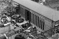
Construction of the dam

Construction of the dam (1931)
Construction of the machine house

tourism

The Bleilochtalsperre is a popular local recreation area that is particularly popular with fans of water sports and hiking. From Saalburg , the most important place directly on the reservoir, whose lower, now flooded districts were relocated as part of the construction work, you can drive on the Bleiloch reservoir with passenger ships.
Driving on the reservoir with motor boats is limited to the period from March 1st to November 30th. A permit is required for boats whose power exceeds 15 hp; this can be obtained from the tourist office in Saalburg-Ebersdorf.
In the area of the reservoir, guided hikes with trained nature guides are offered, e.g. B. in the Saalburg, Sopoten , Bad Lobenstein , Blankenstein , Harra u. a. Information on this is available from the nature guides of the Thuringian Slate Mountains / Obere Saale Nature Park . The slopes of the Bleilochtalsperre are designated as a European bird sanctuary.
Events
Since 1997, the SonneMondSterne festival has been taking place on the east bank on the second weekend in August and now has over 40,000 visitors. From September 12 to 16, 2012, the Bleilochtalsperre was the venue for the Hovercraft World Championship. Since 2005, the Bleilochlauf has been held at the Bleiloch reservoir in April, with runs of 12, 24 and 46 kilometers. In addition, the traditional Thuringian Whitsun regatta in canoe racing always takes place on the Whitsun weekend. The hosting association WSV Rosenthal e. V. welcomes an average of 600 athletes from Germany and Austria on the regatta course in Saaldorf. In June the Bad Lobensteiner rowing regatta, hosted by the Bad Lobensteiner rowing club, takes place.

See also
- List of dams in Germany
- List of the largest reservoirs on earth
- List of bodies of water in Thuringia
literature
- Harald Mitteldorf: The history of the Saale dams (1890–1945) . Jena 2007. ISBN 978-3-939718-03-1
- College of authors: Dams in Thuringia . Thuringian dam administration, 1993
- Vattenfall Europe Mining & Generation (Ed.): Bleiloch pumped storage power plant . 75 years of power generation. Cottbus November 2007 ( online as PDF , 568 KiB [accessed on January 29, 2013] anniversary brochure).
Web links
- All information about activities around the reservoir at a glance
- Historical film about the construction of the Bleilochtalsperre 1930–1932
- The Saale dam at the Kleiner Bleiloch from the civil engineering department of the Potsdam University of Applied Sciences
Individual evidence
- ↑ The Bleilochtalsperre on the Saale on the website of the Landmarks of Civil Engineering, accessed on May 15, 2018.
- ^ Saale-Orla district: Saale-Orla district - protected areas in the Saale-Orla district. Retrieved June 8, 2018 .
- ↑ www.vattenfall.de
- ↑ www.thueringen.de (PDF)
- ^ Federal Network Agency power plant list (nationwide; all network and transformer levels). As of July 2, 2012. ( Microsoft Excel file, 1.6 MiB) Archived from the original on July 22, 2012 ; Retrieved July 21, 2012 .
- ^ Harald Mitteldorf: The history of the Saale dams (1890-1945) . Vopelius, Jena 2007, ISBN 3-939718-03-3 .
- ↑ Jörg Roesler, Dagmar Semmelmann: … nothing works without energy! ”. The East German energy industry from the combines to VEAG (1980-2001) . Ed .: VEAG. Self-published by VEAG, Berlin 2001, ISBN 3-00-009267-6 , p. 192 .
- ↑ Ordinance of the Saale-Orla-Kreis district office of February 1, 2013 for the use of the Bleilochtalsperre
- ↑ festivalguide.de ( Memento from March 22, 2013 in the Internet Archive )
- ↑ Hovercraft WM 2012 ( Memento from August 28, 2012 in the Internet Archive )
- ↑ Lead hole
- ↑ Regatta - LRV1932. Retrieved March 11, 2020 .