Obernitz
|
Obernitz
City of Saalfeld / Saale
Coordinates: 50 ° 37 ′ 39 ″ N , 11 ° 22 ′ 53 ″ E
|
|
|---|---|
| Height : | 220–260 m above sea level NN |
| Incorporation : | July 1, 1950 |
| Postal code : | 07318 |
| Area code : | 03671 |
|
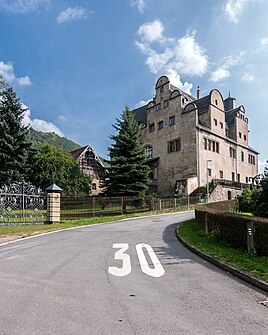
Castle complex
|
|
Obernitz is a district of the city of Saalfeld / Saale in the Saalfeld-Rudolstadt district in Thuringia .
geography
Obernitz is located south of the core town of Saalfeld outside of the former outskirts on the federal highway 85 and on the Saale , which has to overcome a weir at the level of the locality . This is where the stream branches off, which operated the Neumühle in Saalfeld, where the Mauxion chocolate factory was later built. Saalfeld can be reached via a road bridge over the Saale in the north of the village. The place is located in a short side valley of the Saale between the Bohlenberg with the steeply sloping plank wall on the edge of the NSG of the same name in the north and the Pfaffenberg in the south. The historic district around Obernitz is docked , slopes and wooded east of the Saale. In the floodplain there are fertile soils close to the groundwater. On the slopes are plateau-like plains that are used for agriculture. The climate is balanced and mild.
history
Obernitz was first mentioned in a document on June 19, 1258.
To this day, the former village and the current district is characterized by agriculture, forestry and foreign trade. In the corridor of Obernitz, the Gleitsch protrudes as a pointed spur from the north into the Saale valley and thus changes the course of the Saale to a sharp bend to the south, then to the west and north. The mountain forms a striking natural point. There is the Devil's Bridge with a cave opening to the south. Paleolithic stone drawings were also found here. In addition, finds from the later Bronze Age could be recovered. Above this settlement point there was a rampart with a place of sacrifice on the summit. The slope of this mountain towards the Saale forms a long, approximately 120 meter high rock wall, the so-called plank wall . The plank wall is included in the list of national geotopes .
- See Obernitz Castle
- See Evangelical Church
It was incorporated into the city of Saalfeld on July 1, 1950.
Web links
Individual evidence
- ^ Wolfgang Kahl : First mention of Thuringian towns and villages. A manual. 5th, improved and considerably enlarged edition. Rockstuhl, Bad Langensalza 2010, ISBN 978-3-86777-202-0 , p. 208.
- ↑ Michael Köhler: Pagan sanctuaries. Pre-Christian places of worship and suspected cultural sites in Thuringia. Jenzig-Verlag Köhler, Jena 2007, ISBN 978-3-910141-85-8 , pp. 137-138.
- ↑ Message on the website of the city of Saalfeld ( page no longer available , search in web archives ) Info: The link was automatically marked as defective. Please check the link according to the instructions and then remove this notice. Queryed on October 12, 2011
- ↑ Land use plan of the city of Saalfeld, Section 3.2. History (PDF; 6.7 MB) Retrieved on December 22, 2011
