
Uhlstädt-Kirchhasel
| coat of arms | Germany map | |
|---|---|---|

|
Coordinates: 50 ° 44 ' N , 11 ° 25' E |
|
| Basic data | ||
| State : | Thuringia | |
| County : | Saalfeld-Rudolstadt | |
| Height : | 526 m above sea level NHN | |
| Area : | 121.64 km 2 | |
| Residents: | 5729 (Dec. 31, 2019) | |
| Population density : | 47 inhabitants per km 2 | |
| Postal code : | 07407 | |
| Primaries : | 036742, 036743, 03672 | |
| License plate : | SLF, RU | |
| Community key : | 16 0 73 109 | |
| Community structure: | 32 districts | |
| Address of the municipal administration: |
Jenaische Strasse 90 07407 Uhlstädt-Kirchhasel |
|
| Website : | ||
| Mayor : | Toni Huebler | |
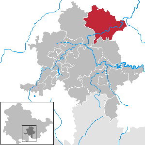
| Location of the community of Uhlstädt-Kirchhasel in the Saalfeld-Rudolstadt district | ||
  |
||


Uhlstädt-Kirchhasel is a municipality in the Saalfeld-Rudolstadt district in Thuringia .
geography
Uhlstädt-Kirchhasel was the largest municipality in terms of area in the Saalfeld-Rudolstadt district until 2018. It occupies the northeastern part of the district. In the south of the municipality lies the Saale valley , in which the districts Catharinau, Kolkwitz, Weißen, Rückersdorf and Niederkrossen (right bank) as well as Kirchhasel, Etzelbach, Uhlstädt and Zeutsch (left bank) are located. All other districts are scattered on the Ilm-Saale-Platte north of the Saale valley. The western districts border on the city of Rudolstadt and are therefore more attractive for residential and commercial space than the other places in the community. The highest mountains in the municipality reach heights of up to 450 meters, while the height in the Saale valley is around 190 meters.
Districts (as of December 31, 2010)


|
|
|
|
In addition, today's Töpfersdorf desert, abandoned in 1850, is located in the community hallway.
history
In Kuhfraß there was an estate belonging to the von Kochberg family . It was taken over in 1825 by James Patrick Parry, Luise von Stein's husband. He had the Hirschhügel hunting lodge built from 1835 to 1838 . In 1892 Count Henckel von Donnersmarck inherited the property. In 1941 a children's home was set up in the “New House”. In 1945 the castle and property were expropriated without compensation. The castle became a retirement home and psychiatric facility, now (2010) it is a retirement home of a social welfare organization. In 1994/1995, the remaining mobile inventory was returned to the Henckel von Donnersmarck family, who concluded a permanent loan agreement with the Weimar Classic Foundation . This included paintings, graphics, art objects, furniture and 39 Goethe drawings.
Incorporations
The community of Uhlstädt-Kirchhasel was created on July 1st, 2002 through the voluntary amalgamation of eleven previously independent communities, all of which, with the exception of Kirchhasel, belonged to the Uhlstädt administrative community. On December 1, 2007, the communities Großkochberg and Heilingen were incorporated, for which Uhlstädt-Kirchhasel was already a fulfilling community.
| Former parish | date | annotation |
|---|---|---|
| Beutelsdorf | July 1, 2002 | |
| Catharinau | April 9, 1994 | Incorporation to Kirchhasel |
| Dorndorf | July 1, 2002 | |
| Engerda | July 1, 2002 | |
| Etzelbach | April 9, 1994 | Incorporation to Kirchhasel |
| Großkochberg | December 1, 2007 | |
| Heilingen | December 1, 2007 | |
| Kirchhasel | July 1, 2002 | |
| Kleinkochberg | April 9, 1994 | Incorporation to Großkochberg |
| Small grains | 1922 | Incorporation to Uhlstädt |
| Kolkwitz | April 9, 1994 | Incorporation to Kirchhasel |
| Cow eating | July 1, 1950 | Incorporation to Kirchhasel |
| Mötzelbach | June 30, 1994 | Incorporation to Kirchhasel |
| Naundorf | January 1, 1957 | Incorporation to Kirchhasel |
| Neusitz | April 9, 1994 | Incorporation to Kirchhasel |
| Niederkrossen | July 1, 2002 | |
| Oberhasel | July 1, 1950 | Incorporation to Kirchhasel |
| Oberkrossen | 1922 | Incorporation to Uhlstädt |
| Partschefeld | 1st December 1972 | Incorporation to Uhlstädt |
| Röbschütz | July 1, 1950 | Incorporation to Heilingen |
| Rödelwitz | July 1, 2002 | |
| Rückersdorf | 1922 | Incorporation to Uhlstädt |
| Schlosskulm | July 1, 2002 | |
| Forge | July 1, 2002 | |
| Pond willows | July 1, 2002 | |
| Uhlstädt | July 1, 2002 | |
| Zeutsch | July 1, 2002 |
Population development
Development of the population (December 31) :
|
|
|
- Data source: Thuringian State Office for Statistics
politics
Municipal council
The 2019 election resulted in the following distribution of seats:
| Party / list | Seats |
|---|---|
| Free voters | 6 (−1) |
| CDU | 4 (−3) |
| LEFT | 4 (+1) |
| BfL 1 | 3 (+3) |
| SPD | 3 (± 0) |
mayor
Toni Hübler (CDU) has been the full-time mayor since 2014. Before that, Peter Schröter had been Mayor of Uhlstädt-Kirchhasel since 2002.
In the mayoral election 2020, Frank Dietzel (Die Linke) prevailed in the runoff election on July 12, 2020 with 50.4% of the valid votes cast; he will take office on October 8, 2020.
coat of arms
Blazon : “Quartered; Field 1: green, field 2 to 4: silver; Field 1 shows a silver owl with outspread wings, fields 2 and 3: three green lilies each, field 4: a green hazelnut bush with six leaves and two fruits on a green background covered with blue wavy bars with silver borders. "
Culture and sights

Kochberg Castle and Weissenburg Castle deserve special mention .
Parts of the village church Uhlstädt date from the 12th century.
In the center of the district Zeutsch recalls in a park near the kindergarten since 1985 a stele to the concentration camp prisoners , the case of a death march from one of the satellite camp of Buchenwald concentration camp were driven through the town.
The Saaleradweg leads through the community, as does the 6 km long Saalleitenweg . The Uhlstädter Heide nature reserve begins in the southeast of the municipality .
Economy and Infrastructure
Uhlstädt-Kirchhasel is a largely agricultural community. This is especially true for the northern districts. Some of those in the Saale Valley also have smaller commercial areas with various industries.
The most important road connections in the municipality are the federal road 88 ( Rudolstadt - Jena ), which runs in the Saale Valley through the districts of Kirchhasel, Etzelbach, Uhlstädt and Zeutsch, and the state road from Teichel in the west to Zeutsch in the east for the northern parts of the municipality. There are also numerous district and municipal roads that open up all districts. Stations of the hall train there in Zeutsch and Uhlstädt Uhlstädt. Since December 2017, the long-distance traffic stops in Jena, Saalfeld and Naumburg have been largely eliminated due to the opening of the high-speed route Ebensfeld- Erfurt, making the next town with regular long-distance traffic Erfurt, which can be reached via Jena-Göschwitz with a change in a good 75 minutes.

The Klinik an der Weißenburg , part of the Swedish health company Capio, is the most important employer in the area.
Personalities
- Christian Sigismund Voigt (18th century), organ builder
- Johanna Isabella Eleonore von Wallenrodt (1740–1819), writer
- Marthe Renate Fischer (1851–1925), writer
- Gerhard Fickel (1920–1990), former chief physician at the Tbc-Heilstätte Weißeneck-Weißenburg-Etzelbach
Web links
Individual evidence
- ^ Population of the municipalities from the Thuringian State Office for Statistics ( help on this ).
- ↑ StBA: Changes in the municipalities in Germany, see 2002
- ↑ StBA Area: changes from 01.01. until December 31, 2007
- ↑ Election of the municipal council Uhlstädt-Kirchhasel 2019. wahlen.thueringen.de, accessed on August 1, 2019 .
- ↑ Election of the municipal council Uhlstädt-Kirchhasel 2014. wahlen.thueringen.de, accessed on August 1, 2019 .
- ^ Thuringian State Office for Statistics: Mayoral elections in Thuringia, community Uhlstädt-Kirchhasel. Retrieved August 8, 2020 .
- ^ Frank Dietzel is the new mayor of Uhlstädt-Kirchhasel. Ostthüringer Zeitung, July 12, 2020, accessed on August 8, 2020 (German).

Allendorf | Altenbeuthen | Bad Blankenburg | Bechstedt | Cursdorf | Deesbach | Döschnitz | Drognitz | Graefenthal | Hohenwarte | Katzhütte | Kaulsdorf | Koenigsee | Lehesten | People Mountain | Meura | Probstzella | Rohrbach | Rudolstadt | Saalfeld / Saale | Schwarzatal | Schwarzburg | Sitzendorf | Uhlstädt-Kirchhasel | Unterweißbach | Unterwellenborn