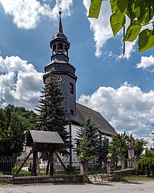
Niederkrossen
|
Niederkrossen
Community Uhlstädt-Kirchhasel
Coordinates: 50 ° 45 ′ 31 ″ N , 11 ° 31 ′ 20 ″ E
|
|
|---|---|
| Height : | 177 (160-186) m above sea level NN |
| Residents : | 231 |
| Incorporation : | July 1, 2002 |
| Postal code : | 07407 |
| Area code : | 036742 |
Niederkrossen is a district of the municipality of Uhlstädt-Kirchhasel in the Saalfeld-Rudolstadt district in Thuringia .
Geography and geology
Niederkrossen is 175 m above sea level to the right of the Saale at the confluence of the Hüttner Bach stream northeast of the district of Zeutsch . The wooded slopes of the Saale-Orlaplatte, lying on red sandstones , begin southeast of Niederkrossen . In the Saaleaue is alluvial Aueboden.
Neighboring places
Neighboring towns are the city of Orlamünde to the north, Freienorla to the northeast , Hütten to the southeast and Zeutsch to the southwest .

history
The village was first mentioned in 1071 as Crozne (possibly derived from Slav. "Krosn": loom, fishing net). In the 13th century people lived from fishing, agriculture and linen weaving. In 1660, six estates cultivated the village's land. In 1985, the castle of the noble family von Eichenberg, who had previously resided in the area, was demolished because it was in disrepair.
From 1991 to 2002 the place belonged to the administrative community Uhlstädt . With the dissolution of this on July 1, 2002, the merger with ten other communities took place to form the new unified community Uhlstädt-Kirchhasel.
The village has 280 inhabitants.
Attractions
The Petruskirche dates from 1408. Here is also the bell of the former church of the deserted Töpfersdorf. The Töpfersdorf ruin on the Heide is a popular excursion destination.
Web links
Individual evidence
- ^ Wolfgang Kahl : First mention of Thuringian towns and villages. A manual. 5th, improved and considerably enlarged edition. Rockstuhl, Bad Langensalza 2010, ISBN 978-3-86777-202-0 , p. 198.
- ↑ a b Niederkrossen on the website of the municipality of Uhlstädt-Kirchhasel . Retrieved August 11, 2017.
- ^ Thuringian State Office for Statistics
