Weißbach (Uhlstädt-Kirchhasel)
|
Weissbach
Community Uhlstädt-Kirchhasel
Coordinates: 50 ° 43 ′ 25 ″ N , 11 ° 27 ′ 4 ″ E
|
||
|---|---|---|
| Height : | 230 m above sea level NN | |
| Residents : | 108 (December 31, 2010) | |
| Incorporation : | July 1, 1950 | |
| Incorporated into: | Whites | |
| Postal code : | 07407 | |
| Area code : | 036742 | |
|
Location of Weißbach in Thuringia |
||
|
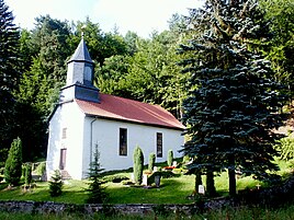
Village church
|
||
Weißbach is a district of the municipality of Uhlstädt-Kirchhasel in the Saalfeld-Rudolstadt district in Thuringia .
location
The village of Weißbach is located on the right of the Saale just after the exit of Weißen about 9 km from Rudolstadt in an elongated side valley of the Saale valley that runs southwards . The street village is surrounded by forests and heather 230 m above sea level . 105 people live in the village with an idyllic church built in 1834. The former field mark of the place is hardly suitable for tractors. The soil is mostly on red sandstone weathering.
Neighboring towns are to the north of Weißen with Oberkrossen , to the west of Etzelbach .
history
It was first mentioned in a document on April 6, 1498.
Son of the village
- Constantin Sorger (1829–1877), Lord Mayor of Gera
Web links
Individual evidence
- ↑ Weißbach on the website of the municipality of Uhlstädt-Kirchhasel.Retrieved on August 17, 2017.
- ^ Wolfgang Kahl : First mention of Thuringian towns and villages. A manual. 5th, improved and considerably enlarged edition. Rockstuhl, Bad Langensalza 2010, ISBN 978-3-86777-202-0 , p. 309.


