
Saale


The Saale or Sächsische Saale , formerly also Thuringian Saale or (more rarely) Vogtland Saale , is a river in Bavaria , Thuringia and Saxony-Anhalt . With a length of 413 kilometers, it is the second longest tributary of the Elbe after the Vltava . With an average discharge of 117 m³ / s, it also takes second place behind the Vltava in the ranking of the tributaries with the most water, just before the Havel . The Saale drains an area of 24,167 square kilometers from the source to the mouth.
Since October 3, 1990, the Saale has been a federal waterway from km 0.0 to 124.2 and is looked after by the waterways and shipping administration of the federal government ( Wasserstraßen- und Schifffahrtsamt Magdeburg ).
The largest cities on the Saale are Halle with approx. 240,000 inhabitants, Jena with approx. 110,000 inhabitants and Hof with almost 50,000 inhabitants.
Surname
The Saale rises in Upper Franconia . To distinguish it from the smaller Franconian Saale in Lower Franconia , which flows into the Main , it is officially called the Saxon Saale in the Bavarian part . However, it does not affect the former kingdom or the Free State of Saxony , but it does flow through the area of the former Upper Saxon Empire to Upper Franconia , which existed from the 16th century to the 19th century, and to Thuringia the former Prussian province of Saxony . The terms Thuringian Saale and Vogtland Saale are less common today. The name means something like river passed by willows and occurs several times in Germany and denotes z. B. also a tributary of the Leine . The Saale was mentioned around 973 by the Arab Ibrahim ibn Yaqub under the name S.lawa . At that time, Slavs were already settling on the banks. The Franconian Saale was first mentioned in 777 under the names Sala and Salu in a Fulda document book. The names with the general meaning as flowing water can already be found in the Greek geographer Strabo (about 63 BC to 23 AD). Its Slavic name Solawa , which is still used in Sorbian literature today, goes back to Old High German sol (sul) salt and awa ( auwa, ouwa , Got. Ahva , ahd. Aha ) water , later wet meadow , floodplain . In the Halle area, the name is also associated with the German brine because of the salt springs there , as is the city of Suhl . Presumably the Slavic meaning goes back to the Germanic name, since not all rivers designated as Saale are associated with salt mining.
In compositions with the river name as a defining word, the ending -e was dropped in classical usage. Examples are Saalfeld , Saalburg , Saalbahn , Saalgärten (Rudolstadt), Saalweg (Jena), Saalwiesen (Schwarzenbach / Saale) or Saalkreis (until 2007). In recent times this has been deviated from more frequently, probably also to avoid references to the noun hall. This is how the collar circle around Halle (Saale) has been called the Saalekreis for several years .
course
source

The Saale rises in the Fichtelgebirge between Zell and Weißenstadt on the northwest slope of the Großer Waldstein . The official source of the Saale is at 707 m above sea level. NN . A syenite plate with the inscription: “Source of the Saale, taken by the cities of Münchberg, Schwarzenbach, Hof, Weißenfels, Halle 1869” is attached to the former mouth hole of a mine tunnel, which is covered with raw granite blocks . The initiative to convert the mouth hole into the official source of the Saale came from the city of Münchberg and the cities mentioned in the inscription contributed to the costs. The entire area is now a protected natural monument . The source of the Saale is the starting point for the 427-kilometer Saale cycle path .
Upper course


Between Zell and Hof , on the Münchberg plateau , the Saale flows relatively slowly. Between the confluence of the Tannbach and the Selbitz , it forms the border between Bavaria and Thuringia, formerly part of the " Iron Curtain ". The river then runs across the Thuringian Slate Mountains . There the Saale is dammed several times, the largest reservoirs in a five-stage cascade are the Hohenwarte - and the Bleiloch reservoir .
The area of the middle Saale begins at Kaulsdorf -Weischwitz with the exit of the river from the Thuringian slate mountains and the breakthrough through the edge plates of the Thuringian basin . The river touches there among others Saalfeld / Saale , Rudolstadt and Jena .
At Naumburg the Saale takes up the Unstrut , which is the second longest tributary of the Saale with 192 km.
Lower course
After leaving the Saale-Unstrut-Triasland Nature Park in Weißenfels, the lower course of the Saale begins in a flat landscape through the cities of Weißenfels , Bad Dürrenberg , Merseburg and Halle (Saale) .
In the Old Pleistocene the Saale flowed from Naumburg in the direction of Zwenkau , divided into the Leipziger and Schkeuditz -Lützener Saalearm at Lützen and took up the White Elster south of Zwenkau . It united with the Mulde north of Leipzig , but did not reach the Leipzig area at the beginning of the Elster Glaciation in the Middle Pleistocene . Since then it has flowed northwards over what is now Weißenfels, while its former river bed is used by the White Elster (Leipziger Saalearm).
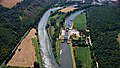
South of Halle is the ecologically valuable Saale-Elster-Aue , in the Halle city area there are several islands and rocks on the shore (Klausberge, Kröllwitzer Felsen with the Saale breakthrough ) and the Giebichenstein with the castle ruins. Below Halle, the Saale passes the steep banks of the Brachwitz Alps, Wettin and the Rothenburg sandstone cliffs from the Oberkarbon and Bernburg (Saale) .
The Saale flows into the Elbe at Barby .
Hydraulic engineering

Reservoirs
The following reservoirs are located on the upper reaches of the Saale in this order :
They form the Saalekaskade , the second largest network of hydropower plants in Germany.
Run-of-river power plants

There are hydropower plants on both the lawn mill weir and the Paradise weir in Jena. They were built on the existing weirs in 1999/2000. Before that, there were locks for rafting at the weirs .
In Halle (Saale) there is a hydropower plant near the Planena district , and two more are to be built at the weirs of Pulverweiden and Trotha.
There are more run-of-river power plants in Unterpreilipp , Uhlstädt , Jena-Burgau , Döbritschen and Camburg as well as in Walsburg , in the old Ziegenrück cardboard factory and in the Ziegenrück hydropower museum.
Tributaries
The river system of the Saale is characterized by three large tributaries, Unstrut , Weisse Elster and Bode . Their tributaries are often more important than most of the direct tributaries of the Saale.
| Surname
|
location | Length in km |
EZG in km² |
MQ in l / s |
Mouth | GKZ |
|---|---|---|---|---|---|---|
| Saxon Saale above the Haidbach | right | 8.5 | 16.7 | northwest of Sparneck | 56-111 | |
| Haidbach | Left | 6.7 | 21.1 | northwest of Sparneck | 56-112 | |
| Pulschnitz | Left | 11.4 | 28.1 | west of Weißdorf- Oppenroth | 56-114 | |
| Ulrichsbach | Left | 6.9 | 17.3 | west of Weißdorf- Oppenroth | 56-116 | |
| Formitz | right | 6.8 | 14.1 |
320 (14.52 km²) |
above Schwarzenbach- Förbau | 56-1176 |
| Lamitz | right | 22.5 | 68.9 |
242 (26.3 km²) |
Fattigau | 56-1192 |
| Schwesnitz | right | 25.2 | 102.6 |
673 (84 km²) |
Oberkotzau | 56-12 |
| Oelsnitz | Left | 14.3 | 37.3 |
325 (36.2 km²) |
court | 56-132 |
| Southern Regnitz | right | 33.8 | 114.8 |
877 (92.5 km²) |
court | 56-14 |
| Krebsbach | right | 6.4 | 11.2 | North courtyard | 56-1518 | |
| Northern Regnitz | right | 7.7 | 41.8 | Hof- Unterkotzau | 56-152 | |
| Goestrabach | Left | 11.8 | 36.2 | above Köditz- Saalenstein | 56-154 | |
| Tannbach | right | 8.7 | 29.0 | above Hirschberg | 56-156 | |
| Ehrlichbach ( Wedenbach ) | right | > 10 | Hirschberg | 56-157? | ||
| Lehestenbach | right | > 10 | above Hirschberg- Sparnberg | 56-158 | ||
| Selbitz | Left | 36.8 | 245.6 |
3000 (213 km²) |
Blankenstein near Bad Lobenstein | 56-16 |
| Lemnitz | Left | 46.7 | below Harras | 56-172 | ||
| Friesau | Left | > 10 | opposite Bad Lobenstein- Saaldorf | 56-173? | ||
| Pößnigsbach | right | > 10 | above Saalburg ( Bleilochtalsperre ) | 56-173? | ||
| Triebisbach | right | > 10 | Saalburg ( Bleilochtalsperre ) | 56-173? | ||
| Wettera | right | 58.2 | Graefenwarth ( Bleilochtalsperre ) | 56-174 | ||
| Retschbach | Left | > 10 | east of Remptendorf ( Bleilochtalsperre ) | 56-176 (?) | ||
| Wisenta | right | 55 | 175.7 |
1240 (158 km²) |
Walsburg near Schleiz ( Walsburg dam ) | 56-18 |
| Plothenbach | right | 39.5 | Ziegenrück | 56-192 | ||
| Debra | right | 31.7 | Ziegenrück | 56-194 | ||
| Otterbach | Left | 54.2 | under. Ziegenrück | 56-196 | ||
| Loop bottom | right | > 10 | north of Altenbeuthen (Behinn Hohenwarte reservoir ) | 56-197? | ||
| Lothrabach | Left | > 10 | above Hohenwartes ( Hohenwarte reservoir ) | 56-197? | ||
| Loquitz | Left | 33.7 | 364.3 |
3830 (362 km²) |
Kaulsdorf | 56-2 |
| Gißrabach | Left | > 10 | Saalfelder Höhe- Reschwitz | 56-311? | ||
| Weira | right | 22.7 | Saalfeld / Saale | 56-312 | ||
| Schwarza | Left | 53 | 507.0 |
4690 (341 km²) |
Rudolstadt- Schwarza | 56-32 |
| Schaalbach | Left | > 10 | Rudolstadt | 56-331? | ||
| Remdaer gutter | Left | 85.4 | Rudolstadt | 56-332 | ||
| Haselbach | Left | > 10 | Uhlstädt-Kirchhasel- Kirchhasel | 56-333? | ||
| Schadebach | right | 19.4 | Uhlstädt-Kirchhasel- Kolkwitz | 56-334 | ||
| Wiedabach | Left | 29.6 | Uhlstädt-Kirchhasel- Zeutsch | 56-336 | ||
| Krebsbach | right | 17.0 | Uhlstädt-Kirchhasel- Niederkrossen | 56-338 | ||
| Hüttener Grund | right | > 10 | Uhlstädt-Kirchhasel- Niederkrossen | 56-339? | ||
| Orla | right | 35 | 258.2 |
1350 (255 km²) |
Outdoor orla | 56-34 |
| Dehnabach | Left | > 10 | Grosseutersdorf | 56-351? | ||
| Leubengrund | right | > 10 | Kleineutersdorf | 56-351? | ||
| Reinstadt Bach | Left | 61.0 | Kahla | 56-352 | ||
| Pürschützer valley | right | > 10 | Schöps- Jägersdorf | 56-353? | ||
| Trout stream ( stream from Altendorf ) | Left | 30.1 | Schöps | 56-354 | ||
| Leutra | Left | > 10 | Jena- Maua | 56-358 (?) | ||
| Roda | right | 34 | 262.3 |
1180 (254 km²) |
Jena- Lobeda | 56-36 |
| Felsbach | Left | <10 | Jena- Burgau | 56-371? | ||
| Pennickenbach | right | <10 | Jena- Wöllnitz | 56-371? | ||
| Ammerbach | Left | > 10 | Jena-South | 56-371? | ||
| Leutra | Left | 37.7 | Jena-West | 56-372 | ||
| Gembdenbach | right | > 10 | Jena- Wenigenjena | 56-373? | ||
| Steinbach | Left | <10 | Jena- Löbstedt | 56-373? | ||
| Gönnerbach | Left | 10 | 19.7 | Neuengönna near Jena | 56-374 | |
| Tracks | right | 19th | 66.4 | Golmsdorf near Jena | 56-376 | |
| Tautenburger valley | right | 23.9 | Dorndorf-Steudnitz | 56-378 | ||
| Tümplingbach | right | > 10 | Camburg- Tümpling | 56-379? | ||
| Ilm | Left | 129 | 1042.7 |
5890 (894.3 km²) |
Big herring near Naumburg | 56-38 |
| Unstrut | Left | 192 | 6364.2 | 30300 (6218 km²) |
Naumburg | 56-4 |
| Wethau | right | 30th | 238.1 |
1010 (205 km²) |
Naumburg | 56-52 |
| Rippach | right | 27 | 171.6 | Dehlitz | 56-54 | |
| Ellerbach | right | 42.2 | Bad Durrenberg | 56-55? | ||
| hostage | Left | 23.3 | 252.4 |
517 (208 km²) |
Merseburg | 56-56 |
| Doll | right | 25th | 158.8 | 54 | Schkopau | 56-58 |
| Laucha | Left | 20.2 | 100.7 | Schkopau | 56-59? | |
| White magpie | right | 257 | 5154.0 | 25100 (4939 km²) |
Hall | 56-6 |
| Rossgraben | Left | 8.4 | Hall | 56-71? | ||
| Suction trenches | Left | 3.0 | Hall | 56-71? | ||
| Hechtgraben | Left | 3.0 | Hall | 56-71? | ||
| Götsche | right | 15.3 | 49.1 | Hall | 56-71? | |
| Salza | Left | 48.2 | 568.0 |
991 (547 km²) |
Salzmünde near Halle | 56-72 |
| Slap | Left | 15th | 111.9 | Friedeburg | 56-74 (?) | |
| Schlackenbach | Left | 33.2 | Alsleben | 56-75? | ||
| Bach from Schackstedt | Left | 20.3 | Friedeburg | 56-75? | ||
| Rocker | Left | 85 | 650 |
2400 (544 km²) |
Bernburg | 56-76 |
| Fuhne | right | 59 | 673.0 | Bernburg | 56-78 (?) | |
| Bode | Left | 169 | 3229 | 12600 (3200 km²) |
Nienburg | 56-8 |
| Watering pit | right | 23.8 | Calbe- Trabitz | 56-9? | ||
| Dove | right | 35 | 414.7 | Barby | 56-9? |
flora
For free development of flora without human intervention would result, according to the Federal Agency for Nature Conservation , a potential vegetation Luzulo and - beech forests on the upper reaches, sessile oak - and hornbeam forests , both on the middle reaches as the linkssaalischen underflow and oaks - and hornbeam forests on rechtssaalischen underflow.
.jpg)
In the Fichtelgebirge, the Saale rises in the middle of extensive forests. These form the habitat for protected plant species such as B. arnica , bush carnation , frog herb , Turk's union and juniper .
In the Thuringian-Franconian low mountain range of flow happens behind Hof (Saale) largely deforested Münchberger plateau with its spruce - monocultures and separated later in the Vogtland , the low in the area cultivated is on the right bank of the Franconian Forest on the left. It is proven that the Franconian Forest was almost completely cleared at the end of the 19th century. Today the spruce, some of which occurs in monocultures, is the most visible representative of the flora.
Spruce and pine trees also characterize the Upper Saale Valley in Thuringia with its wooded valley valleys . The difficulty in agricultural use promoted the development of autochthonous coniferous forests and semi-natural deciduous forests.
In the Slate Mountains Nature Park , pines and spruces dominate the scene. It is over 80% forested. Acid oak , birch and pine mixed forests represent the remaining areas of natural forest cover without a forestry background.
The Middle Saale valley has changed a lot due to human influences. Backwaters and pastures lined with willow only exist in a few places, and the Saale cascade ensures that the Saale flows evenly without regular flooding. Agriculture dominates . Along the Middle Saale, mixed forests with a large number of beech trees characterize the catchment area of the river; this vegetation is the most common natural area in Germany.
Between Saalfeld / Saale and Dornburg-Camburg , especially near Jena , lean , semi-arid and dry lawns that thrive on shell limestone slopes characterize the landscape and extend to the adjacent plateaus. Wild species of orchids and summer avens settle on them in the Jena area. A form of the rattle pots (Rhinanthus) only exists outside of southern Europe at this location. On the southern mountain slopes, the neobiotic black pine is currently driving away the ancestral flora.

In the Saale-Unstrut wine-growing region in southern Saxony-Anhalt , the Müller-Thurgau grape variety is primarily cultivated, followed by the Pinot Blanc and Silvaner varieties . Coming from Austria, the Silvaner arrived in the region around 1670 and dominated local viticulture for a long time .
Field elms and bushes predominate in the Saale-Elster-Aue , including hawthorns , blackthorns and elderberries .
In the region around Halle an der Saale , environmental pollution by dust and ashes from industrial and private sources and the disadvantages of anthropogenic eutrophication as a result of intensive agricultural fertilization collide; in the 20th century, the soils inevitably accumulated excessively lime, sulfur and salt. Nevertheless, the flora is home to some plant species that are rare in Germany, such as the narrow-flowered grape hyacinth , the high violet and the Illyrian buttercup . The most successful invasive plant in the Halle (Saale) urban area is the lilac .

In the Bergholz nature reserve, a low-precipitation loess landscape provides the basis for life for sessile oak, silver birch and winter linden , as well as the usual beech species. The area is affected by oak death and borders on intensively agriculturally used areas. In the floodplain forests between Halle (Saale) and Bernburg (Saale) , wood anemones , yellow anemones , lark spurs and marsh marigolds thrive alongside tree and shrub species . The arid sites are covered by feather grass , pearl grass , spring Adonis , meadow sage and others.
In the Salzland district with the towns of Bernburg, Nienburg (Saale) and Calbe (Saale) , the Saale has areas for flooding and well-tended recreational areas, but the floodplains are very narrow in relation to the potential flood plains that arable farming requires.
Communities along the Saale
From the source to the mouth.
Bavaria
Zell - Sparneck - Weißdorf - Schwarzenbach an der Saale - Oberkotzau - Hof - Köditz - Töpen - Berg (Upper Franconia) - Issigau
Thuringia
Hirschberg - Rosenthal am Rennsteig - Bad Lobenstein - Saalburg-Ebersdorf - Schleiz - Eßbach - Ziegenrück - Drognitz - Hohenwarte - Kaulsdorf - Saalfeld - Rudolstadt - Uhlstädt-Kirchhasel - Orlamünde - Freienorla - Großeutersdorf - Kleineutersdorf - Kahla - Großpürschütz - Schöps - Rothenstein - Jena - Neuengönna - Dornburg-Camburg - large herring
Saxony-Anhalt
.jpg)
Molauer Land - Naumburg - Schönburg - Goseck - Weißenfels - Lützen - Bad Dürrenberg - Leuna - Merseburg - Schkopau - Teutschenthal - Halle - Wettin-Löbejün - Salzatal - Gerbstedt - Könnern - Alsleben - Plötzkau - Bernburg - Nienburg - Calbe - Barby
From the Thuringia / Saxony-Anhalt state border, the Saale flows past the following places:
Sights and buildings


Saale with its tributary Unstrut lies wine region Saale-Unstrut . Along the river passing Fernradweg Saale-cycle path . The cycle path is particularly demanding in terms of cycling tourism in the upper and middle reaches . The Via Regia partly follows the course of the Saale.
With its often towering slopes, the Saale flows, among other things, at Burgk Castle , Heidecksburg near Rudolstadt , Leuchtenburg in Seitenroda , Kunitzburg ( near Jena ), Dornburg castles , Saaleck Castle , Rudelsburg near Bad Kösen , Schönburg Castle , the Castle Goseck , at Schloss Neu-Augustusburg in Weissenfels , at the Burg Giebichenstein on the Saale breakthrough in Halle (Saale) and at Schloss Bernburg over. In Halle (Saale), Moritzburg is also located on the bank of the Mühlgraben, a branch of the river.
The river passes Wettin Castle north of Halle . It is the ancestral seat of the Wettins , who ruled over most of Thuringia ( Ernestines ) between the Thuringian-Hessian War of Succession in 1264 and the end of the monarchy in 1918 , as well as all electors and kings of Saxony from 1423 to 1918 .

The Rudolphstein motorway bridge lies between Thuringia and Bavaria . As a result of the division of Germany, one directional carriageway on the A9 runs along a construction from 1936 and the other on a construction from 1996.
The Saale Valley is an important traffic artery between Saalfeld and Naumburg. Because of the narrowness in the valley, the traffic routes often have to change sides of the river. The federal highway 88 and the Saalbahn railway line , for example, run along this section of the river . The Thuringian Railway alone crosses the river eight times over bridges in the narrow Saale valley.
The pedestrian suspension bridge near Klein- and Großeutersdorf, shortly before Jena, is a special monument. The so-called "swing bridge" (built in 1908) is unique in Europe.
The Bad Kösen Saale bridge from 1892 with its characteristic turrets on the bridge piers is also a tourist attraction.
To the south of Halle, the new Erfurt – Leipzig / Halle railway line spans the Saale. The Saale-Elster viaduct since its completion in 2013, with a length of eight kilometers, the longest bridge in Germany.
Importance as a traffic route
The use of the Saale for goods or passenger transport has been documented since 981. From the mouth of the Unstrut, the river is partially navigable for small passenger ships, from Halle (Saale) continuously. As part of the Elbe / Saale waterway expansion, the total length was shortened by straightening in the years 1933 to 1942 from 427 kilometers to around 413 kilometers. From km 124.16 near Bad Dürrenberg to km 0.00 confluence with the Elbe (at km 290.78) the Saale is a federal waterway for which the Magdeburg Waterways and Shipping Office is responsible.
From Bad Dürrenberg to above the port of Halle-Trotha, the Saale is designated as waterway class I , from there to the Elbe as class IV. In the Federal Transport Infrastructure Plan 2030 , the Saale was assigned to the category "outside the core network" (< 0.6 million t / a). The expansion of the Saale and Saale Canal is not included in the Federal Waterway Expansion Act, which was issued on the basis of the Federal Transport Infrastructure Plan. There has been no freight traffic on the Saale for years. In 2018, the handling of goods to barges in the port of Halle was declared over and since then the port has only been operated as a container terminal for transshipment between road and rail. In Bernburg, Halle, Merseburg and Bad Kösen there are shipping companies that operate small passenger ships, mostly only on individual congestion-controlled sections of the Saale.
The construction of the Elster-Saale Canal , which was intended for river navigation and which was to lead to Leipzig, began in 1933 and was never completed. Its name goes back to a 2.5 km long canal from the Elster that was built in the middle of the 19th century. The eleven-kilometer section in the federal states of Saxony-Anhalt and Saxony, which was completed and flooded in 1939, has been officially called the Saale-Leipzig Canal (SLK) since 1999 and is one of the " other federal waterways ".
Another, incomplete canal project is the central canal near Merseburg.
River expansion
After resistance from environmental groups, construction of a barrage in the lower reaches of the Saale was abandoned; instead, a lock canal at Tornitz , the so-called Saale Canal , is currently being planned.

Criticism of the planned river expansion
The planned Saale Canal is also rejected by environmental groups, in particular the BUND , parts of the Left Party and Alliance 90 / The Greens . A study by the Martin Luther University Halle-Wittenberg comes to the conclusion that “the estimated investment costs of 72.6 million euros (...) are not matched by any adequate benefit expectations”. The environmental research center Leipzig-Halle and the taxpayers' association are calling for the construction project to be canceled.
The estimated costs have risen from the originally expected 72.6 million to now 100 million euros, which is why the Saalekanal has often been criticized in the media. Thousands of people demonstrate against the expansion of the Elbe and the ecological consequential damage every year along the entire Elbe.
The Association for the Elevation of Saale Shipping (VHdS) argues against this with the results of surveys from companies in the region, which assume a possible transport potential of more than two million tons per year. The VHdS also considers the maintenance measures planned by the federal government for the Elbe up to 2010 to guarantee a travel depth from Hamburg to Dresden of 1.60 meters to be urgently necessary for the success of the project.
Bridges and ferries across the Saale


The largest road bridges include the Saale bridge on the A 72 at Hof, the Saale bridge Rudolphstein on the A 9 across the former inner-German border, the Saale valley bridge on Jena on the A 4, the Saale bridge on Schkortleben on the A 38 and the Saale bridge on Beesedau on the A 14.
With the Saale-Elster valley bridge , the largest bridge in Germany and the longest long-distance railway bridge in Europe spans the Saale near Halle (Saale) .
Among the historically valuable bridges, the Alte Saalebrücke Jena-Burgau , the Camsdorfer Brücke , the Kunitzer Hausbrücke , the Carl-Alexander-Brücke in Dorndorf-Steudnitz and the Saalebrücke Bad Kösen are to be highlighted.
The following ferries run across the Saale (downstream):
- the car ferry on the L 1100 between Altenroth and Linkenmühle
- the Gierseilfähre between Brachwitz (Fährstrasse) and Bad Neu Ragoczy (Alte Dorfstrasse)
- the chain ferry at the national road 156 in Wettin
- the Gierseilfähre on Landesstrasse 155/157 in Rothenburg
- the motor ferry unit in Bernburg
- the greed ferry between Calbe (Saale) and Gottesgnaden
- the Gierseilfähre on the district road 1243 in Groß Rosenburg
Locks of the Saale
To ensure the navigability of the Saale, there are numerous locks in the lower reaches: The list of locks in the Saale lists all existing and incomplete locks along the river and in the canal-like branches that carry water from the hall to improve navigation or for hydrological reasons.
Rothenburg lock, aerial view (2017)

Planena lock , in the background the Schkopau power plant
Oeblitzschleuse between Schönburg and Leißling , in the background Goseck Castle
_001,_Schleuse_Rothenburg.jpg)


Inland ports of the Saale
- Halle (Saale) port , Trotha district, no more cargo handling on the ship
- Sophienhafen Halle (Saale), no longer in operation
Tributaries
Over the centuries, tributaries have repeatedly emerged in the entire course of the river. The city of Halle is traversed by the branches Elisabeth-Saale and Wilde Saale .
Flood
For the city of Halle (Saale), the floods between 1559 and 1958 were examined by the Halle geographer Gerhard Zinke. The level rose over ten meters on March 2, 1595 (10.15 m), on 24/25. February 1799 (10.12 m) and on 24./25. November 1890 (10.10 m). The nine-meter mark was exceeded ten times.
In Thuringia, the following floods are considered to be the strongest in recent decades:
- April 1962
- April 1994
- May / June 2013
See also
- Geology of the Middle Saale Valley
- Thuringian Basin
- Ilm-Saale-Platte
- Saale complex (also called Saale Ice Age, Saale Ice Age or Saale Glacial)
literature
- Franz X. Bogner: The Saale from the air. From the source to the mouth . Sutton-Verlag, Erfurt 2014, ISBN 978-3-95400-371-6 .
- Ernst-Otto Luthardt , Reinhard Feldrapp : On the Saale. From the Fichtel Mountains through Thuringia to the Elbe. Weidlich / Flechsig, Würzburg 1990, ISBN 3-8035-1335-9 .
- Hansjörg Küster : The Elbe. Landscape and history. Beck, Munich 2007, ISBN 978-3-406-56209-9 . (Chapter 14: The Saale)
- Wolf Thieme, Markus Altmann (photos): Right in the heart. It rises in Bavaria, crosses Thuringia and flows into the Elbe in Saxony-Anhalt - the Saale is a river that connects everything. And everyone has fun: the athlete, the culture lover, the idler. In: stern . No. 26, June 22, 2006, pp. 84-89. ( Online version ).
- Rudolstadt and the middle Saale valley (= values of the German homeland . Volume 58). 1st edition. Verlag Hermann Böhlaus successor, Weimar 1998, ISBN 3-7400-0934-9 .
- H. Faist: The shipping conditions on the Saale waterway. In: Inland Shipping. Jhrg. 46, No. 22, 1991, pp. 1128-1132, ISSN 0939-1916 .
Web links
- Blue ribbon - information about the Saale in Thuringia and Saxony-Anhalt
- Association for the promotion of shipping on the Saale
- Hall initiative hall
Individual evidence
- ↑ a b c Michael Bergemann: Complete list of flowing waters in the Elbe catchment area . Authority for Environment and Energy, Hamburg July 1, 2015 ( PDF; 802 KB [accessed on November 29, 2015]).
- ^ German Hydrological Yearbook Elbe Region, Part I 2014. (PDF) State Office for Flood Protection and Water Management Saxony-Anhalt, p. 159 , accessed on November 3, 2018 (from: lhw.sachsen-anhalt.de).
- ↑ Hall . In: Meyers Konversationslexikon. quoted from retrobibliothek.de
- ^ Sources in the Fichtel Mountains. ( Memento of the original from January 6, 2014 in the Internet Archive ) Info: The archive link was inserted automatically and has not yet been checked. Please check the original and archive link according to the instructions and then remove this notice. Municipality of Weißenstadt am See
- ↑ p. 55 awa auwa ouwa ahva aha water, meadow
- ^ Lothar Eißmann : The Quaternary of the Leipzig lowland bay and adjacent areas around the Saale and Elbe . Model of a landscape development at the edge of the European continental glaciation. In: Board of the Society for Geological Sciences of the GDR (Hrsg.): Series of publications for geological sciences . Issue 2. Akademie-Verlag, Berlin 1975.
- ^ Otfried Wagenbreth, Walter Steiner: Geologische Streifzüge. German publishing house for basic industry, Leipzig 1982, DNB 821136712 , p. 80.
- ↑ 600 kW hydropower plant lawn mill weir Jena / Saale. In: www.enplan.de. Archived from the original on April 24, 2015 ; accessed on November 28, 2015 .
- ↑ 600 kW hydropower plant Paradieswehr Jena / Saale. In: www.enplan.de. Archived from the original on April 24, 2015 ; accessed on November 28, 2015 .
- ↑ a b www.saalekraftwerke.de
- ↑ www.saale-online.de
- ^ Thuringian state report on the management plans and programs of measures according to the EU Water Framework Directive Thuringian Ministry of Agriculture, Forests, Environment and Nature Conservation; Erfurt, November 2010; Retrieved February 5, 2019; On: thueringen.de (PDF; German; 7.59 MB)
-
↑ The length of the Laucha of 20.2 km was measured in the
Saxony-Anhalt Viewer of the State Office for Surveying and Geoinformation ( notes )
from the source southwest of Schafstädts to the mouth. - ↑ floraweb.de
- ↑ genussregion.oberfranken.de
- ↑ Nature & Landscape - Plants. Fichtelgebirge Nature Park V., accessed on November 29, 2015 .
- ↑ Kulturlandschaft.fh-erfurt.de
- ↑ jena.de ( Memento of the original from March 20, 2015 in the Internet Archive ) Info: The archive link was inserted automatically and not yet checked. Please check the original and archive link according to the instructions and then remove this notice.
- ↑ tlug-jena.de
- ↑ winzervereinigung-freyburg.de ( Memento of the original from March 4, 2016 in the Internet Archive ) Info: The archive link was automatically inserted and not yet checked. Please check the original and archive link according to the instructions and then remove this notice.
- ↑ lvwa-natur.sachsen-anhalt.de ( Memento of the original from April 2, 2015 in the Internet Archive ) Info: The archive link was automatically inserted and not yet checked. Please check the original and archive link according to the instructions and then remove this notice.
- ↑ calbe.de
- ↑ Directory E, Ser. No. 51 of the Chronicle ( Memento of the original from September 16, 2016 in the Internet Archive ) Info: The archive link was inserted automatically and has not yet been checked. Please check the original and archive link according to the instructions and then remove this notice. , Federal Waterways and Shipping Administration
- ↑ a b Lengths of the main shipping lanes of the federal inland waterways ( Memento of the original from January 21, 2016 in the Internet Archive ) Info: The archive link was automatically inserted and not yet checked. Please check the original and archive link according to the instructions and then remove this notice. , Federal Waterways and Shipping Administration
- ↑ Federal Transport Infrastructure Plan 2030 , pdf, 7.3 MB
- ↑ Law on the expansion of federal waterways and amending the Federal Waterways Act of December 23, 2016 , pdf, 46 kB
- ↑ "Hafen Halle" no longer exists . MDR, March 10, 2018
- ↑ Directory F of the Chronicle ( Memento of the original from September 16, 2016 in the Internet Archive ) Info: The archive link was inserted automatically and has not yet been checked. Please check the original and archive link according to the instructions and then remove this notice. , Federal Waterways and Shipping Administration
- ↑ Website www.saaleelsterkanal.de
- ↑ elbeinsel.de
- ↑ Trees. Green Youth of Saxony-Anhalt, archived from the original on July 19, 2011 ; accessed on November 29, 2015 .
- ^ Statement from the Halle-Leipzig Environmental Research Center from May 22, 2003 (PDF; 119 kB)
- ↑ Bernd Hansjürgens: No more wasting taxpayers money - the discussion about the expansion of the Saale and Elbe should finally end . In: Torgauer Zeitung . Torgauer Verlagsgesellschaft, Torgau November 24, 2008 ( online ( memento of September 24, 2011 in the Internet Archive ) [accessed on November 29, 2015]). No more wasting taxpayers money - The discussion about the Saale and Elbe expansion should finally be ended ( memento of the original from September 24, 2011 in the Internet Archive ) Info: The archive link was automatically inserted and not yet checked. Please check the original and archive link according to the instructions and then remove this notice.
- ↑ Stolpe's Spirit Channel . In: Der Spiegel . No. 20 , 2003 ( online ).
- ↑ Robert von Lucius: Urgent need for a useless project . In: Frankfurter Allgemeine Zeitung . July 31, 2008, p. 4 ( online ( memento of July 18, 2011 in the Internet Archive ) [accessed on November 29, 2015]). Urgent need for a useless project ( memento of the original from July 18, 2011 in the Internet Archive ) Info: The archive link was automatically inserted and not yet checked. Please check the original and archive link according to the instructions and then remove this notice.
- ^ Concrete in river landscapes. In: TAZ. June 6, 2008.
- ↑ Regional alliance against the deepening of the Elbe ( Memento of the original of July 18, 2011 in the Internet Archive ) Info: The archive link was automatically inserted and not yet checked. Please check the original and archive link according to the instructions and then remove this notice.
- ↑ ferry. In: bernburger-freizeit.de . Bernburger Freizeit GmbH, accessed on May 6, 2019 .
- ↑ Bodo Müller: Map of the waters of Germany northeast. Edition Maritim, Hamburg 2002, ISBN 3-89225-341-2 .
- ^ Blue ribbon in Saxony-Anhalt Saale locks
- ^ Günther Zinke: The historical development of the hydrographic conditions in the city region of Halle with special consideration of the flood conditions. In: C. Ohlig (Hrsg.): Halle and the Saale - interweaving of the 1200-year-old city with its surrounding area through water management and mining as well as subsequent industries. (= Writings of the German Water History Society. Volume 15). Siegburg 2011, p. 181.
- ↑ jena.de
- ↑ jena.de
- ↑ What natural hazards do Thuringians have to expect? Thuringian Ministry for the Environment, Energy and Nature Conservation, accessed on November 29, 2015 .