
Dehlitz (Saale)
|
Dehlitz
City of Lützen
Coordinates: 51 ° 13 ′ 59 ″ N , 12 ° 1 ′ 0 ″ E
|
|
|---|---|
| Height : | 109 m |
| Area : | 8.78 km² |
| Residents : | 544 (Dec. 31, 2009) |
| Population density : | 62 inhabitants / km² |
| Incorporation : | January 1, 2011 |
| Postal code : | 06686 |
| Area code : | 03443 |
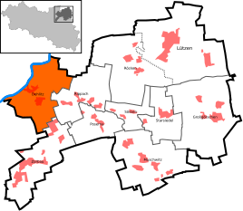  Location of Dehlitz in Lützen
|
|

Dehlitz (Saale) is a district of the city of Lützen in the Burgenland district in Saxony-Anhalt .
geography
Dehlitz is located northeast of Weißenfels , at the confluence of the Rippach and the Saale . Losau and Oeglitzsch are designated as districts.
,_Oeglitzsch_001.jpg)
history


Dehlitz was first mentioned in a document in 993. On May 17, 1684, the rectory was badly damaged by a sudden downpour. In today's district of Lösau, the master builder Hans Manck was convicted in 1771 in an insulting process . He had claimed that part of the taxes the peasants had paid would always go away because it was witch money . He was jailed for six days and made public apologies . A memorial stone in the manor park commemorates the observation point of Frederick the Great in the Battle of Roßbach .
Dehlitz, Oeglitzsch and Lösau belonged to the Electorate of Saxony and the Kingdom of Saxony until 1815 . Dehlitz and Oeglitzsch were subordinate to the Hochstift-Merseburg office of Lützen , which had been under Electoral Saxon sovereignty since 1561 and belonged to the secondary school principality of Saxony-Merseburg between 1656/57 and 1738 . Lösau was on the northern edge of the Electoral Saxon office of Weißenfels ( Burgwerben court seat), which belonged to the Secondogenitur Principality of Saxony-Weißenfels between 1656/57 and 1746 .
As a result of the resolutions of the Congress of Vienna , Dehlitz and Oeglitzsch with the western part of the Lützen office and Lösau with the Weißenfels office came to Prussia in 1815. In 1816 they were assigned to the Merseburg administrative district of the province of Saxony . While Dehlitz and Oeglitzsch were assigned to the Merseburg district, Lösau came to the Weißenfels district .
During the first district reform in the GDR, Dehlitz and Oeglitzsch were reclassified into the Weißenfels district on July 1, 1950 and united with Lösau to form the Dehlitz municipality. During the second district reform in 1952, Dehlitz came to the Weißenfels district in the Halle district , which in 1990 became the Weißenfels district again and was incorporated into the Burgenland district in 2007.
The municipality of Dehlitz was incorporated into the city of Lützen by law on January 1, 2011 and thereby lost its political independence. Until it was dissolved, it belonged to the Lützen-Wiesengrund administrative community , which had its administrative headquarters in the city of Lützen and also ceased to exist on January 1, 2011.
Population development
- 1933: 400 inhabitants
- 1939: 396 inhabitants
- 2009: 544 inhabitants


Sights / tourism
Buildings
The village church, built around 1500, has a large baroque columned altar in the choir head and an epitaph for J. v. Wolffersdorff from 1613, made of alabaster and black marble. In the year 2000 the "Association for the Preservation of the Village Church Dehlitz / Saale eV" was founded. Through the active commitment of the members of the association and the z. The worst damage could be repaired partly free of charge from the local craft businesses. Today the church is used for ecclesiastical and cultural events.
The old manor was built around 1730 by Daniel Bodo Graf von der Schulenburg as a mansion. At the same time he had laid out the park with the famous hanging beech. In 1845, Richter's ancestors bought the property. As part of the land reform, the rulers expropriated the family in 1945. For a long time the building served as a school and later the community took over the house.
At the Mühlgraben, a tributary of the Rippach, east of the village is the historic water mill "Obermühle", which is still operated as a grist mill . A water wheel drives two roller mills there.
Treben (desert)
From the former village only the church from the 12th century, which is located in a well recognizable wall and stands on a hill above the confluence of the Rippach into the Saale, has survived. Some Slavic burial sites made of brown coal quartzite have also been preserved. The fields of the village, abandoned in 1555, were sold to the surrounding towns in 1594.
After Treben were u. a. Kleben, Lösau and Nellschütz parish.
Cycle path
The Saale-Unstrut-Elster-Radacht runs through Dehlitz.
Economy and Infrastructure

traffic
In the immediate vicinity of the village runs the federal highway 87 (L188), as well as the federal highway 91 , which leads from Halle to Zeitz , and the federal highways 9 and 38 .
The Großkorbetha – Deuben railway runs through the village , on which since 1999 only coal trains have been running between Wählitz (just before Hohenmölsen ) and Großkorbetha.
Personalities
Sons and daughters of the village
- Ernst Leberecht Wagner (1829–1888), physician
- Danko von Funcke (1829–1896), member of the Reichstag and district administrator in Cottbus
- Reinhard Hauptmann (* 1947), soccer player
literature
- Sebastian Schulze: The village church Dehlitz an der Saale . Sax-Verlag , Beucha 2007
Web links
- Website of the association for the preservation of the village church Dehlitz / Saale eV
Individual evidence
- ↑ Manfred Wilde : The sorcery and witch trials in Saxony . Böhlau, Cologne / Weimar / Vienna 2003, ISBN 3-412-10602-X , p. 545 ( limited preview in Google Book search).
- ^ Karlheinz Blaschke , Uwe Ulrich Jäschke : Kursächsischer Ämteratlas. Leipzig 2009, ISBN 978-3-937386-14-0 , pp. 84 f.
- ^ Karlheinz Blaschke , Uwe Ulrich Jäschke : Kursächsischer Ämteratlas. Leipzig 2009, ISBN 978-3-937386-14-0 , p. 36 f.
- ^ Johann Ernst Fabri: Geography for all estates. First part, third volume, which contains the resolution of the "Franconian circle", and some sections of the "Upper Saxon circle". Schwickertscher Verlag, Leipzig 1791, p. 378
- ^ The district of Merseburg in the municipal directory 1900
- ^ The district of Weißenfels in the municipality register 1900
- ↑ Dehlitz and its districts on gov.genealogy.net
- ↑ Law on the reorganization of the municipalities in the state of Saxony-Anhalt concerning the district of Burgenlandkreis.
- ↑ StBA: Area changes from January 1st to December 31st, 2011
- ↑ Anka Stolper-Heinike: Rollers squeeze the grain. In: mz-web.de. August 28, 2009. Retrieved July 3, 2018 .
