
Burgenland district
| coat of arms | Germany map |
|---|---|

|

Coordinates: 51 ° 9 ' N , 11 ° 53' E |
| Basic data | |
| State : | Saxony-Anhalt |
| Administrative headquarters : | Naumburg (Saale) |
| Area : | 1,413.67 km 2 |
| Residents: | 178,846 (Dec. 31, 2019) |
| Population density : | 127 inhabitants per km 2 |
| License plate : | BLK, HHM, NEB, NMB, WSF, ZZ |
| Circle key : | 15 0 84 |
| NUTS : | DEE08 |
| Circle structure: | 33 municipalities |
| Address of the district administration: |
Schönburger Strasse 41 06618 Naumburg |
| Website : | |
| District Administrator : | Götz Ulrich ( CDU ) |
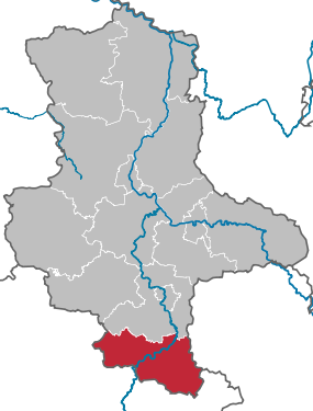
| Location of the Burgenland district in Saxony-Anhalt | |
  |
|

The Burgenlandkreis is a district in Saxony-Anhalt that emerged from the old Burgenlandkreis and the Weißenfels district as part of the second district reform on July 1, 2007 .
geography
The district is located on the southern border of Saxony-Anhalt, it borders on Thuringia in the west and south and on Saxony in the east .
In the north it borders on the Saalekreis , in the northeast on the Saxon district of Leipzig , in the east on the Thuringian district of Altenburger Land , in the south on the Thuringian independent city of Gera and the districts of Greiz , Saale-Holzland-Kreis and Weimarer Land, and in the west the also Thuringian districts of Sömmerda and Kyffhäuserkreis .
The landscape is hilly and is shaped by the Saale , Unstrut and Weißer Elster . Viticulture is practiced in the Saale-Unstrut region.
The Unstrut crosses the border from Thuringia to Saxony-Anhalt in the north-west of the district near Wendelstein and flows into the Saale near Naumburg in the flower base. At Großheringen / Kleinheringen, the Saale crosses the border from Thuringia to Saxony-Anhalt in the south-west and leaves the district in the north-east near Wengelsdorf into the Saalekreis. From the southwest to the northeast flows from Crossen in Thuringia via Zeitz the White Elster, which leaves the district northeast of Profen in the direction of Pegau in Saxony.
history
The Burgenlandkreis came into being as a result of the regional reform of the Landtag of Saxony-Anhalt on July 1st, 2007 . The previously existing Burgenlandkreis merged with the Weißenfels district . The regional administration office had chosen the Burgenland district as the plan name . In the district council meeting on July 16, 2007, however, a majority voted for the old name Burgenlandkreis. The main reason was the cost of the renaming. For the revision of the place name signs and all printed matter for offices and authorities in the former Weißenfels district, August 1, 2007 was determined for the official introduction of the new district name.
On May 25, 2009, the district received the title “ Place of Diversity ” awarded by the federal government .
The district name is an artificial name created in 1994 that alludes to the numerous medieval castles in the district. The Rudelsburg near Bad Kösen is one of the better known .
In 2015 the skeletal remains of an old resident of Karsdorf , which belong to the linear ceramic culture (approx. 5200 BC), were analyzed, and it turned out that they belong to the paternal T1a-M70 lineage and the maternal H1 line .
Population development

Development of the population (territorial status from November 1, 2011 / from 1995 reference date December 31, before October 3) :
- 1990: 245.946
- 1995: 231.315
- 2000: 222.262
- 2005: 207.727
- 2009: 196.422
- 2012: 186.081
According to the 4th regionalized population forecast by the State Statistical Office of Saxony-Anhalt from January 30, 2007, 152,032 inhabitants will still live in the Burgenland district in 2025.
politics
District council
The last local election took place on May 26, 2019 . Based on the election result shown on the right, the distribution of seats in the district council was as follows:
Burgenland District Assembly 2019
- Left : 6
- Greens : 3
- SPD : 7
- We Weißenfelser : 2
- ZLB / BDZ : 1
- BFW / rural communities : 1
- Burgenland district citizen list : 1
- VBL : 1
- FW-BLK : 4
- FDP : 3
- CDU : 15
- AfD : 9
- NPD : 1
- Overview of the results of past district council elections
| Parties and constituencies | Percent 2019 | Seats 2019 | Percent 2014 |
Seats 2014 |
Percent 2007 |
Seats 2007 |
Percent 2004 |
Percent 1999 |
|
|---|---|---|---|---|---|---|---|---|---|
| CDU | Christian Democratic Union of Germany | 28.2 | 15th | 41.3 | 22nd | 38.7 | 23 | 33.2 | 40.3 |
| AfD | Alternative for Germany | 17.3 | 9 | 3.8 | 2 | - | - | - | - |
| SPD | Social Democratic Party of Germany | 12.5 | 7th | 15.0 | 8th | 18.3 | 11 | 24.5 | 28.1 |
| THE LEFT. | THE LEFT. | 11.7 | 6th | 16.0 | 9 | 18.4 | 11 | 23.2 | 18.2 |
| FW-BLK | Burgenland Free Electoral Association | 7.2 | 4th | 2.8 | 2 | - | - | - | - |
| GREEN | Alliance 90 / The Greens | 5.5 | 3 | 6.0 | 3 | 4.2 | 3 | 3.0 | 2.2 |
| FDP | Free Democratic Party | 5.0 | 3 | 3.1 | 2 | 9.0 | 5 | 8.7 | 4.4 |
| WW | We Weißenfelser | 4.2 | 2 | - | - | - | - | - | - |
| NPD | National Democratic Party of Germany | 2.5 | 1 | 4.7 | 3 | 4.7 | 3 | 3.8 | - |
| ZLB / BDZ | Zeitzer List-Citizens Alliance Droißiger-Zeitzer Forest | 1.9 | 1 | 1.0 | 1 | - | - | - | - |
| BFW / rural communities | Citizens for Weißenfels / rural communities | 1.7 | 1 | 3.1 | 2 | - | - | - | - |
| BL BLK | Burgenlandkreis citizens' list | 0.8 | 1 | - | - | - | - | - | - |
| VBL | United list of citizens for Naumburg, Bad Kösen and the associated communities | 0.7 | 1 | - | - | - | - | - | - |
| FWZ / FFW / BIT | Free voters Zeitz / Voluntary Fire Brigade / Citizens' Initiative Theißen | - | - | 1.1 | - | - | - | - | - |
| BV-BLK | Disabled Association eV | - | - | 0.8 | - | 2.3 | 1 | 0.9 | - |
| BLZ-DZF | Citizen List Zeitz / Droißiger-Zeitzer Forest | - | - | 0.5 | - | - | - | - | - |
| WBB | Weißenfelser Bürgerbund - community of voters for a free, safe and democratic Weißenfels | - | - | 0.3 | - | - | - | - | - |
| BBB | Citizens' Alliance of Burgenland | - | - | - | - | 1.2 | 1 | - | - |
| BfW | Citizen for Weißenfels | - | - | - | - | 0.6 | 1 | - | - |
| INSTEAD of party | INSTEAD OF THE PARTY The Independents | - | - | - | - | 0.4 | - | - | - |
| KPD | Communist Party of Germany (1990) | - | - | - | - | 0.2 | - | - | - |
| WASG | Work & Social Justice - The Alternative Choice | - | - | - | - | 0.2 | - | - | - |
| EB | Individual applicants | 0.8 | - | 0.6 | - | 1.9 | 1 | 1.1 | 0.5 |
| Otherwise. | Others | - | - | - | - | - | - | 1.5 | 6.3 |
| total | 100 | 54 | 100 | 54 | 100 | 60 | 100 | 100 | |
| voter turnout | 53.6% | 45.3% | 37.3% | 59.5% | 52.8% | ||||


- EB: Individual applicants 2014: Volker Kohlmann; 2007–2014: Volker Kohlmann; 2004: Volker Kohlmann, 1999: k. A.
- The results from 1999 and 2004 were converted to the 2007 territorial status.
The following parliamentary groups were formed in the district council: CDU / FDP (18 members), AfD (9 members), SPD (incl. ZLB / BDZ, 8 members), DIE LINKE. (6 members), FW / BfW / rural communities (5 members), GRÜNE / VBL (4 members), WW / BL BLK (3 members). One member (NPD) is non-attached.
District Administrator
For the 2014 local elections, the incumbent incumbent, Harri Reiche, no longer stood. Since none of the candidates achieved the required absolute majority in the first ballot on May 25th, there was a runoff election between Götz Ulrich (CDU) and Manuela Hartung (SPD) 3 weeks later, on June 15th . This was won by the CDU candidate Götz Ulrich with 61.4% of the votes cast and a voter turnout of 23%.
coat of arms
The coat of arms was approved on February 19, 2008 by the Ministry of the Interior of Saxony-Anhalt.
Blazon : "In silver a black-grooved red castle, the lowered castle wall occupied by two pinnacle towers abutting at the top and disappearing into the outer edge, between the towers a six-berry (3: 2: 1) blue grape with two green leaves, the castle wall covered with a gold one Sign with a black miner's toe inside. "
The coat of arms was designed by the heraldist Jörg Mantzsch from Magdeburg.
The coats of arms of the administrative communities, cities and municipalities of the district can be found in the list of coats of arms in the Burgenland district .
flag
The flag is red and white (1: 1) striped (horizontal shape: stripes running horizontally, lengthways shape: stripes running vertically) and centered with the district coat of arms.
Economy and Infrastructure
The Burgenland district belongs to the central German economic area Halle-Leipzig-Dessau. The region can fall back on a traditional economic structure with a mix of industries, medium-sized businesses and crafts.
When new investors settled in, especially in the industrial areas on the Federal Motorway 9 (e.g. Zorbau or Oberkaka ), the focus was on logistics . These locations have excellent conditions for the traffic-intensive industries.
In the Future Atlas 2016 , the Burgenlandkreis was ranked 383 out of 402 districts and independent cities in Germany, making it one of the regions with “high future risks”.
Clinics

There are three acute clinics in the district, namely the Asklepios Clinic in Weißenfels and the clinics in Naumburg and Zeitz, which belong to the municipal clinic Burgenlandkreis GmbH. The rehabilitation clinics are concentrated in Bad Kösen: The Burgenlandklinik is an SRH subsidiary, while the three clinics of the Lielje Group (Saale rehabilitation clinic with clinics I and II and the children's rehabilitation clinic) are taken over by the Median clinics .
media
There is a TV station BLK Regional TV in the Burgenland district, which can be received via the local cable network and the Internet. There is also the Internet radio station Burgenland-Welle.
traffic
Rail transport


The main routes Halle – Erfurt , Leipzig – Großkorbetha and Saaleck – Saalfeld run through the district . On the common section Großkorbetha - Saaleck , in which the cities Weißenfels and Naumburg are also located, both passenger and freight traffic are bundled and therefore take place at high frequency.
With the discontinuation of long-distance transport, the state of Saxony-Anhalt ordered an extensive replacement range of accelerated local transport connections, which are operated by Abellio Rail Central Germany and DB Regio . These include the lines RE 16 Halle – Naumburg – Erfurt, RE 17 Naumburg – Erfurt, RE 18 Halle – Naumburg – Jena and RE 42 Leipzig – Naumburg – Jena – Nuremberg as well as RB 20 Leipzig – Naumburg – Erfurt – Eisenach and RB 25 Halle– Naumburg – Jena – Saalfeld. There are also the regional railway lines Unstrutbahn Naumburg – Wangen (Abellio), Weißenfels – Zeitz (DB Regio Südost) and Leipzig – Zeitz – Gera ( Elster-Saale-Bahn ) in the district. Passenger traffic on the Naumburg – Teuchern – Zeitz line was canceled in 2010.
The district belongs, like its predecessors, to the Central German Transport Association (MDV). Since the timetable change on December 13, 2015, the MDV tickets are also valid on the half-hourly trams in the district town of Naumburg .
The high-speed line Erfurt – Leipzig / Halle runs through the west of the district. Since its completion in December 2015 and the subsequent route to Nuremberg in December 2017, only a few long-distance trains have been running in the Saale Valley. The Unstruttal bridge near Karsdorf as part of the new line is the second longest railway bridge in Germany with a length of 2668 m after the Saale-Elster valley bridge .
Road traffic

The federal autobahn 9 leads between Schkeuditzer Kreuz and Hermsdorfer Kreuz in a north-south direction through the east of the district (exits: Weißenfels, Naumburg, Droy says ). At the Rippachtal motorway junction, there is the junction to the federal motorway 38 , which touches the north (exit: Leuna / Weißenfels, Lützen ). There are still good connections to the southern district from the federal motorway 4 (exits: Gera , Apolda ).
The federal highway 180 , an important north-south connection in Saxony-Anhalt, leads from Querfurt through the district from northwest to southeast, crosses the A 9 at Pretzsch and leads to Meuselwitz in Thuringia.
In the southeast of the district, the B 91 coming from the Saalekreis , the B 2 coming from Leipzig in Saxony and going to Gera in Thuringia and the B 180 coming from Naumburg meet in Zeitz .
In the north-east of Weißenfels the federal highway 91 (Halle-Zeitz), the B 87 (Weimar-Leipzig) and the B 176 ( Kölleda / Thuringia- Borna / Saxony) converge.
In Naumburg the federal roads intersect 87 (Weimar-Leipzig) and 180 (Eisleben-Altenburg), also here that begins B 88 (Naumburg-Jena).
Finally, the federal road 250 Querfurt – Nebra – Bad Bibra – Eckartsberga should be mentioned.
air traffic
Air traffic is served from Leipzig / Halle Airport (in Saxony, approx. 30 km from the district border) and the regional airport Leipzig-Altenburg Airport (in Thuringia, approx. 15 km from the district border). There are still the landing sites Laucha (Unstrut) and Sprossen bei Zeitz in the district.
Communities
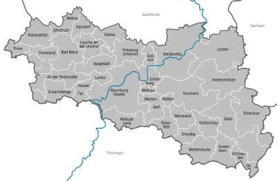

Unified municipalities
(cities arehighlighted in bold )
(* seat of the district)
| coat of arms | local community | Residents | Area in km² |
|---|---|---|---|
|
|
Elsteraue | 8108 | 79.96 |
|
|
Hohenmölsen | 9611 | 75.31 |
|
|
Lützen | 8523 | 96.49 |
|
|
Naumburg (Saale) * | 32,155 | 129.9 |
|
|
Teuchern | 8086 | 81.36 |
|
|
Weissenfels | 40.192 | 113.55 |
|
|
Time | 27.601 | 87.18 |
Association communities with their member communities
(* seat of the association community)
| coat of arms | Member parish | Residents | Area in km² |
|---|---|---|---|
|
|
On Poststrasse | 1689 | 44.45 |
|
|
Bad Bibra * | 2706 | 49.77 |
|
|
Eckartsberga | 2318 | 35.96 |
|
|
fin | 1161 | 25.04 |
|
|
Finneland | 1045 | 29.42 |
|
|
Imperial Palace | 1533 | 41.08 |
|
|
Lanitz-Hassel Valley | 1069 | 31.5 |
| coat of arms | Member parish | Residents | Area in km² |
|---|---|---|---|
|
|
Drunk * | 1969 | 20.32 |
|
|
Gutenborn | 1728 | 33.91 |
|
|
Kretzschau | 2424 | 27.76 |
|
|
Schnaudertal | 917 | 20.72 |
|
|
Weather cap | 1737 | 41.45 |
| coat of arms | Member parish | Residents | Area in km² |
|---|---|---|---|
|
|
Balgstädt | 1112 | 32.58 |
|
|
Freyburg (Unstrut) * | 4571 | 46.55 |
|
|
Gleina | 1199 | 29.58 |
|
|
Goseck | 1009 | 14.56 |
|
|
Karsdorf | 1448 | 19.84 |
|
|
Laucha on the Unstrut | 2831 | 31.14 |
|
|
Nebra (Unstrut) | 3064 | 25.42 |
| coat of arms | Member parish | Residents | Area in km² |
|---|---|---|---|
|
|
My pain | 1032 | 25.25 |
|
|
Mertendorf | 1639 | 32.51 |
|
|
Molau country | 1046 | 33.94 |
|
|
Osterfeld * | 2447 | 27.61 |
|
|
Schönburg | 1050 | 14.6 |
|
|
Bumps | 916 | 7.29 |
|
|
Wethau | 910 | 7.67 |


Territory changes
Changes at the community level
Church planting
- Dissolution of the municipalities of Herrengosserstedt , Klosterhäseler and Wischroda - re-establishment of the municipality of An der Poststraße (July 1, 2009)
- Dissolution of the municipalities of Billroda and Lossa - reestablishment of the municipality of Finne (July 1, 2009)
- Dissolution of the municipalities of Kahlwinkel , Saubach and Steinburg - re-establishment of the municipality of Finneland (July 1, 2009)
- Dissolution of the municipalities of Bucha , Memleben and Wohlmirstedt - re-establishment of the municipality of Kaiserpfalz (July 1, 2009)
- Dissolution of the communities Möllern and Taugwitz - re-establishment of the community Lanitz-Hassel-Tal (July 1, 2009)
- Dissolution of the municipalities Altenroda , Golzen , Thalwinkel and the city of Bad Bibra - re-establishment of the city of Bad Bibra (July 1, 2009)
- Dissolution of the municipalities of Burgholzhausen , Tromsdorf and the city of Eckartsberga - re-establishment of the city of Eckartsberga (July 1, 2009)
- Dissolution of the communities of Abtlöbnitz , Casekirchen , Leislau and Molau - reestablishment of the community of Molauer Land (January 1, 2010)
- Dissolution of the communities of Mertendorf, Görschen and Löbitz - re-establishment of the community of Mertendorf (January 1, 2010)
- Dissolution of the communities of Gieckau and Wethau - re-establishment of the community of Wethau (January 1, 2010)
- Dissolution of the communities of Meineweh , Pretzsch and Unterkaka - re-establishment of the community of Anhalt Süd (January 1, 2010)
- Dissolution of the communities Bergisdorf , Droßdorf , Heuckewalde and Schellbach - reestablishment of the community Gutenborn (January 1, 2010)
- Dissolution of the communities Bröckau and Wittgendorf - reestablishment of the community Schnaudertal (January 1, 2010)
- Dissolution of the municipalities of Breitenbach , Haynsburg and Wetterzeube - reestablishment of the Wetterzeube municipality (January 1, 2010)
- Dissolution of the municipalities of Droyßig and Weißenborn - re-establishment of the municipality of Droyßig (January 1, 2010)
- Dissolution of the municipalities of Grana , Kretzschau and Döschwitz - re-establishment of the municipality of Kretzschau (January 1, 2010)
- Dissolution of the communities Großgörschen , Muschwitz , Poserna , Rippach and Starsiedel - re-establishment of the city of Lützen (January 1, 2010)
- Dissolution of the city of Teuchern and the municipalities of Deuben , Gröben , Gröbitz , Krauschwitz , Nessa , Prittitz and Trebnitz - re-establishment of the city of Teuchern (January 1, 2011)
Incorporations

- Dissolution of the municipality of Röcken - incorporation into Lützen (July 1, 2009)
- Dissolution of the municipalities of Döbris , Geußnitz , Kayna , Nonnewitz and Würchwitz - incorporation according to Zeitz (July 1, 2009)
- Dissolution of the municipalities of Burkersroda , Großernitz and Hirschroda - incorporation into Balgstädt (July 1, 2009)
- Dissolution of the communities of Pödelist , Schleberoda , Weischütz and Zeuchfeld - incorporation into Freyburg (Unstrut) (July 1, 2009)
- Dissolution of the municipalities Baumersroda and Ebersroda - incorporation into Gleina (July 1, 2009)
- Dissolution of the municipalities Burgscheidungen and Kirchscheidungen - incorporation into the city of Laucha an der Unstrut (July 1, 2009)
- Dissolution of the municipalities of Wangen (Unstrut) - incorporation into the city of Nebra (Unstrut) (July 1, 2009)
- Dissolution of the municipalities of Granschütz and Taucha - incorporation into the city of Hohenmölsen (January 1, 2010)
- Dissolution of the communities of Langendorf , Markwerben and Uichteritz - incorporation into the city of Weißenfels (January 1, 2010)
- Dissolution of the communities Goldschau , Heidegrund and Waldau - incorporation into the city of Osterfeld (January 1, 2010)
- Dissolution of the communities of Crölpa-Löbschütz , Janisroda , Prießnitz and the city of Bad Kösen - incorporation into the city of Naumburg (Saale) (January 1, 2010)
- Dissolution of the municipalities of Luckenau and Theißen - incorporation into the city of Zeitz (January 1, 2010)
- Dissolution of the municipalities of Burgwerben , Großkorbetha , Leißling , Reichardtswerbe , Schkortleben , Storkau , Tagewerbe and Wengelsdorf - incorporation into the town of Weißenfels (September 1, 2010)
- Dissolution of the municipality of Reinsdorf - incorporation into the city of Nebra (Unstrut) (September 1, 2010)
- Dissolution of the municipalities of Dehlitz (Saale) , Sössen and Zorbau - incorporation into the city of Lützen (January 1, 2011)
Changes in administrative communities
- Dissolution of the administrative community An der Finne - formation of the Verbandsgemeinde An der Finne (July 1, 2009)
- Dissolution of the administrative community Wethautal - re-establishment of the Wethautal community (January 1, 2010)
- Dissolution of the administrative community Droyßiger-Zeitzer Forst - re-establishment of the association community Droyßiger-Zeitzer Forst (January 1st, 2010)
- Dissolution of the Unstruttal administrative community - re-establishment of the Unstruttal community (January 1, 2010)
- Dissolution of the Zeitzer Land administrative community (January 1, 2010)
- Dissolution of the Saale Valley administrative community (September 1, 2010)
- Dissolution of the Weißenfelser Land administrative association (September 1, 2010)
- Dissolution of the administrative community Lützen-Wiesengrund (January 1, 2011)
- Dissolution of the administrative community Vier Berge-Teucherner Land (January 1, 2011)
Protected areas
There are 15 designated nature reserves in the district (as of February 2017).
License Plate
On July 1, 2007, the district was assigned the BLK distinguishing mark, which was introduced in the previous Burgenland district on July 1, 1994 .
As a result of the license plate liberalization , the distinguishing marks HHM (Hohenmölsen), NEB (Nebra (Unstrut)), NMB (Naumburg (Saale)), WSF (Weißenfels) and ZZ (Zeitz) have also been available since November 29, 2012 .
See also
List of destinations and sights in the Burgenland district
Web links
Individual evidence
- ↑ State Statistical Office Saxony-Anhalt, population of the municipalities - as of December 31, 2019 (PDF) (update) ( help ).
- ^ Burgenlandkreis - the district administrator
- ↑ Our Far Forebears (Y-DNA haplogroups)
- ↑ Massive migration from the steppe is a source for Indo-European languages in Europe
- ↑ census database
- ↑ burgenlandkreis.de data & facts
- ↑ https://wahlresults.sachsen-anhalt.de/wahlen/kw19/index.html
- ^ Result of the district election 2014 ( Memento from March 4, 2016 in the Internet Archive )
- ↑ Results of the district council elections 1999–2007 ( Memento from September 8, 2014 in the Internet Archive )
- ^ Result of the district council election BLK 2019. In: Statistisches Landesamt Sachsen-Anhalt. Saxony-Anhalt State Statistical Office, accessed on June 7, 2019 .
- ↑ a b Official Journal of the State Administration Office of Saxony-Anhalt No. 5/2008 page 63 ( Memento from January 16, 2016 in the Internet Archive ) (PDF; 163 kB)
- ↑ Future Atlas 2016. (No longer available online.) Archived from the original on October 2, 2017 ; accessed on March 23, 2018 .
- ↑ Press release of December 18, 2015
- ↑ a b c d e State Statistical Office Saxony-Anhalt, population of the municipalities - as of December 31, 2019 (PDF) (update) ( help ).
- ↑ a b c d e regionalstatistik.de Regional database of the Federal Statistical Office (as of December 31, 2016)
Altmarkkreis Salzwedel | Anhalt-Bitterfeld | Börde | Burgenland District | Dessau-Roßlau | Halle (Saale) | Resin | Jerichower Land | Magdeburg | Mansfeld-Südharz | Saalekreis | Salzlandkreis | Stendal | Wittenberg
Cities: Bad Bibra | Eckartsberga | Freyburg (Unstrut) | Laucha on the Unstrut | Lützen | Naumburg (Saale) | Nebra (Unstrut) | Osterfeld | Weißenfels | Zeitz . Municipalities: An der Poststraße | Balgstädt | Droyziger | Elsteraue | Fin | Finneland | Gleina | Goseck | Gutenborn | Hohenmölsen | Imperial Palace | Karsdorf | Kretzschau | Lanitz-Hassel Valley | My pain | Mertendorf | Molau Country | Schnaudertal | Schönburg | Bumps | Teuchern | Wethau | Weather cap .