
Anhalt-Bitterfeld district
| coat of arms | Germany map |
|---|---|

|

Coordinates: 51 ° 46 ' N , 12 ° 4' E |
| Basic data | |
| State : | Saxony-Anhalt |
| Administrative headquarters : | Koethen (Anhalt) |
| Area : | 1,453.52 km 2 |
| Residents: | 158,486 (Dec. 31, 2019) |
| Population density : | 109 inhabitants per km 2 |
| License plate : | ABI, AZE, BTF, KÖT, ZE |
| Circle key : | 15 0 82 |
| NUTS : | DEE05 |
| Circle structure: | 10 municipalities |
| Address of the district administration: |
Am Flugplatz 1 06366 Koethen (Anhalt) |
| Website : | |
| District Administrator : | Uwe Schulze ( CDU ) |
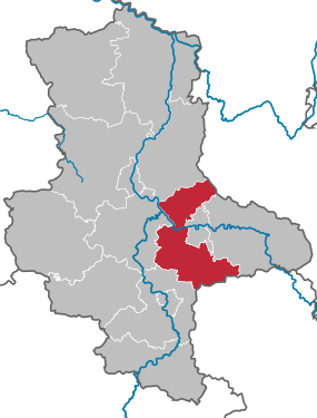
| Location of the district of Anhalt-Bitterfeld in Saxony-Anhalt | |
  |
|
The district of Anhalt-Bitterfeld is a regional authority in the state of Saxony-Anhalt . It was formed in the course of a regional reform on July 1, 2007 from the former districts of Bitterfeld and Köthen and from parts of the previous district of Anhalt-Zerbst .
geography

The sickle-shaped area of the district extends over 1453 km². There is a distance of 59 kilometers from the northernmost town of Nedlitz to the southernmost town of Brehna-Torna, while the westernmost town of Köthen-Dohndorf is 48 kilometers away from the easternmost town of Schwemsal . At its narrowest point at the height of Aken , however, the district is only seven kilometers wide. The landscape is largely agricultural. There are large chemical plants in the Bitterfeld-Wolfen area and, recently, the Solar Valley in Thalheim with photovoltaic operations. In the south, disused lignite opencast mines form a lake landscape, in the north the district extends to the wooded ridge of Fläming , where the 136 meter high vineyard is also the highest point. At Aken, the Elbe in the Middle Elbe Biosphere Reserve divides the district into a northern and a southern half, the south-eastern part is traversed by the Mulde .
Historical development
The name of the district is historically correct only to a limited extent. In the past, the name combination with Anhalt only existed in territories that were actually related to the Principality or Duchy of Anhalt , for example Anhalt-Köthen and Anhalt-Zerbst . The eponymous Bitterfeld , however, never belonged to a Anhalt duchy. However, Bitterfeld belonged to the Electorate of Saxony , which, like Anhalt, was founded by the Ascanians. In the Electorate of Saxony, however, their rule ended in 1423, in Anhalt not until 1918.
In fact, the majority of the district is located in areas that previously belonged to Anhalt, namely the Anhalt-Köthen that was created in 1252 and the Anhalt-Zerbst that split off in 1382. While Anhalt-Zerbst was only independent until the division of Zerbst in 1793, Anhalt-Köthen existed until 1847, from 1807 as a duchy. Both territories became part of the Free State of Anhalt in 1918. The southern area of the district around the cities of Bitterfeld-Wolfen and Brehna belonged from the middle of the 11th century to 1815 to the County of Brehna , which had belonged to the Wettin area since 1423 .

As a result of the Congress of Vienna , the area of the former county with further northern parts of Saxony came to the Prussian province of Saxony and in 1816 was added to the newly formed district of Bitterfeld in the administrative district of Merseburg. In 1918, after the establishment of the Free State of Anhalt, the remaining area became part of the Dessau-Köthen and Zerbst districts.
After the Second World War, all three districts belonged to the state of Saxony-Anhalt. After the GDR territorial reform of 1952, the Köthen and Bitterfeld districts were assigned to the Halle district and the Zerbst district to the Magdeburg district. All three districts continued to exist even after the state of Saxony-Anhalt was re-established in 1990. The second district reform in the state of Saxony-Anhalt in 2007 originally only provided for the merging of the Bitterfeld and Köthen districts. However, through a referendum, the residents of Zerbst and 21 other communities that were originally supposed to go to the district of Jerichower Land , forced an assignment to the district of Anhalt-Bitterfeld. Because of its central location, Köthen was designated as the seat of the district administration.
politics
Anhalt-Bitterfeld district assembly 2019
- THE LEFT. : 7
- GREEN : 3
- SPD : 6
- FWG ABI : 4
- Pro Wolfen : 2
- FFZ : 2
- FWG Anhalt : 1
- Per Muldestausee : 1
- IG BfKAU : 1
- FDP : 3
- CDU : 14
- AfD : 10
On September 23, 2008 the district received the title “ Place of Diversity ” awarded by the Federal Government .
District Administrator
On May 6, 2007, the previous district administrator of the Bitterfeld district, Uwe Schulze, was elected as the new district administrator for Anhalt-Bitterfeld in a run-off election with 70.1 percent of the valid votes and a turnout of 22.0%.
District council
(Result of the local elections on May 26, 2019)
| Parties and constituencies | Percent 2019 |
Seats 2019 |
Percent 2014 |
Seats 2014 |
Percent 2007 |
Seats 2007 |
Percent 2004 |
Percent 1999 |
|
|---|---|---|---|---|---|---|---|---|---|
| CDU | Christian Democratic Union of Germany | 25.9 | 14th | 32.98 | 18th | 30.2 | 16 | 37.2 | 38.4 |
| AfD | Alternative for Germany | 18.7 | 10 | 5.75 | 3 | - | - | - | - |
| THE LEFT. | THE LEFT. | 13.9 | 7th | 21.60 | 12 | 19.8 | 11 | 21.7 | 17.5 |
| SPD | Social Democratic Party of Germany | 11.5 | 6th | 15.29 | 8th | 19.2 | 11 | 20.6 | 29.9 |
| FWG ABI | Free voter community Anhalt-Bitterfeld | 6.5 | 4th | - | - | - | - | - | - |
| FDP | Free Democratic Party | 5.9 | 3 | 4.02 | 2 | 7.9 | 4th | 7.6 | 5.6 |
| GREEN | Alliance 90 / The Greens | 4.9 | 3 | 2.82 | 2 | 3.5 | 2 | 2.5 | 2.5 |
| Pro Wolfen | Pro Wolfen | 3.5 | 2 | 1.61 | 1 | 2.0 | 1 | - | - |
| FFZ | FREE FACTION DESCRIBED | 2.9 | 2 | 2.30 | 1 | - | - | - | - |
| FWG Muldestausee | Free voter community Muldestausee | 2.0 | 1 | 1.08 | 1 | - | - | - | - |
| FW Anhalt | Free voter community Anhalt | 1.7 | 1 | 1.31 | 1 | - | - | - | - |
| IG BfKAU | Interest group citizens for Köthen (Anhalt) and the surrounding area - independent electoral alliance | 1.2 | 1 | - | - | - | - | - | - |
| BI AK / WLS | Citizens' Initiative Anhalt-Köthen / Voter List Sport | 1.0 | - | - | - | - | - | - | - |
| NPD | National Democratic Party of Germany | 0.5 | - | 1.89 | 1 | 3.2 | 2 | - | - |
| WLS | Voters list Sport LK Anhalt Bitterfeld | - | - | 8.53 | 4th | 8.2 | 4th | 4.2 | 2.6 |
| IFW | Initiative of free voters for Bitterfeld-Wolfen | - | - | 0.91 | - | 2.7 | 2 | 2.3 | 1.6 |
| WKA | Voting community Kommunal-Aktiv Anhalt-Bitterfeld | - | - | - | - | 2.4 | 1 | 1.2 | - |
| BIsK Anhalt-Bitterfeld | Citizens' initiative for social communal taxes Anhalt-Bitterfeld | - | - | - | - | 0.7 | - | 0.9 | 0.9 |
| EB | Individual applicants | - | - | - | - | 0.2 | - | 0.2 | 0.3 |
| Others | Others | - | - | - | - | - | - | 1.5 | 0.8 |
| total | 100 | 54 | 100 | 54 | 100 | 54 | 100 | 100 | |
| Turnout in percent | 49.0 | 42.50 | 34.9 | 43.5 | 51.4 | ||||
- EB: Individual applicants 2007: Camilla Nater; 2004 and 1999: k. A.
- The results from 1999 and 2004 were converted to the 2007 territorial status.
The following parliamentary groups have formed in the district assembly: CDU / FDP (17 members), AfD (11 members, including IG BfKAU), FREE VOTERS (10 members, including FWG ABI, Pro Wolfen, FFZ, FWG Muldestausee, FWG Anhalt), SPD / GRÜNE (9 members), DIE LINKE. (7 members).
Coat of arms, flag and official seal


The coat of arms was approved on August 31, 2007 by the Ministry of the Interior of Saxony-Anhalt.
- Description of coat of arms
- "The coat of arms of the district shows in the first field in silver a black bear walking to the left on a red battlement wall, in the second field in gold a red armored, three-toed, black lion with a knocked out tongue, in the third field in silver three red sea leaves and in the fourth field in Red a growing silver palm with fruits. "
Heraldist Jörg Mantzsch was commissioned with the development and scientific documentation of a new coat of arms and the flag .
It was the wish of the decision-makers of the territories - the three district councilors and later the parliamentary group chairmen of all parties - and then the decision of the constituent district assembly to include certain elements in the new coat of arms with which the regions identify from previous coats of arms. These are symbols of Anhalt , of Saxony , the county of Brehna and in the narrower sense of the district of Köthen .
So a fourth shield was decided.
Field 1 shows, on a silver background, a black bear walking to the left on a red battlement wall. The bear symbolizes the Ascanian / Anhalt national emblem, while the wall is known to express the reference to a city. In their title, the Princes of Anhalt included the names Herr zu Bernburg, Zerbst and Gröbzig , which they incorporated elements (in the sense of pars pro toto = a part for the whole) of the city coat of arms (bear on wall) in their national coat of arms expressed. The bear on the wall in the Anhalt-Bitterfeld district coat of arms takes up the meaning of this symbolism by viewing itself as the administrative body representing all cities and municipalities in the district. A breakthrough (gate) in the wall was dispensed with because it was better to hide the circumvention of the Tingist rule, metal must not come into contact with metal . In addition, no direct reference to the state coat of arms should be made. For the latter reason, the bear also walks left, has one more claw than in the state coat of arms, a slightly rounded rear and is without a fold in the back.
Field 2 shows the Saxon-Wettin insignia of the black lion on a gold background. There were hardly any changes here compared to the representation in the previous coat of arms of the Bitterfeld district, whose coat of arms was also quartered.
Field 3 expresses the direct reference to the county of Brehna with the three red sea leaves on a silver background. The historical significance of the Counts of Brehna , who joined the Wettin line and of which larger parts of the country fell to Anhalt, others to Saxony in the later Bitterfeld district, is closely linked to both Anhalt and Saxon history. This can be seen not least in the occurrence of the sea leaves in several city coats of arms in the region.
Field 4 corresponds to the request of the former district of Köthen to incorporate the palm, which has been used in the coat of arms from 1991, into the new district coat of arms. Here, the direct reference to the emblem of the fruit-bearing society (1617–1680), from which the palm tree originates, is not decisive, but rather the reference to the associated motto Everything to Benefit , to which the district council professed. Following the basic rules of tinging , the palm had to be metallic on a colored background (i.e. silver or gold), whereby silver was chosen in order not to make the coat of arms unnecessarily colorful .
The arrangement of the graphic elements in the four-part shield is not random, but in the order of priority, whereby Anhalt (bear) is not to be rated before Saxony (lion), but is in front of the district name and so also in the coat of arms.
The graphic representation of animals, for example in coats of arms, partly corresponds to centuries-old customs. Heraldic images are symbols, not images of reality. They are shown in heraldic style in their graphics. This means that objects or living beings are not reflected in their architectural or anatomical accuracy, but in a heraldic way. A lion, for example, is not depicted in the way an anatomist would draw a lion, but in the way it has been heraldically handed down and codified. It is also important to reflect the concrete lion of the symbol of rule, because there are many lions in coats of arms and they must not be confused, which is why everyone has certain attributes. If we speak of the Wettin lion here and not of the Kur-Saxon or Meißner lion , it is because these terms refer to an identical coat of arms. The House of Wettin provided bishops, the margraves of Meissen and later kings of Saxony, who adorned their coats of arms with the Wettin lion and transferred this symbol to the coat of arms of the cities as a claim to power.
As far as the sea leaves are concerned, they are a coat of arms. Heraldists and laypeople have been arguing about their origin, meaning and appearance as well as their correct designation for centuries. Even the protagonist in terms of heraldic art, Johann Siebmacher , regrets in his book of arms, which first appeared in 1605, that there are almost as many views as representations of sea leaves and that these are always confused. In the meantime, the scientific heraldry of modern times has found formulations and graphic patterns for this. A sea leaf is a water lily leaf similar in its original and actual shape to the linden leaf with an ornamental opening that opens the upper part. The actual origin and meaning of the sea leaves is unknown, as the coats of arms depictions of sea leaves date well before the introduction of heraldic terminology.
Symbolism is also expressed with the palm ( coconut palm ). It was considered a perfectly useful plant, the elements of which were used from the roots as fuel to the trunk, leaves and fruits to the fibers on the coconut, from which mats were woven. In this sense we find it in the emblem of the Fruitful Society.
On July 12, 2007, the new district council decided at its constituent meeting to use the coat of arms created by the Magdeburg local heraldist Jörg Mantzsch and the corresponding flag.
The coats of arms of the administrative communities, cities and municipalities of the district can be found in the list of coats of arms in the Anhalt-Bitterfeld district .
- Flag description
- "The flag is black and yellow (1: 1) striped lengthways and centered with the county coat of arms."
With the lengthwise format the stripes are vertical, with the landscape format they run horizontally.
- Official seal
The district has an official seal that corresponds to the official seal attached to the main statute. The signature reads: "Landkreis Anhalt-Bitterfeld".
Infrastructure
.jpg)

traffic
A dense network of federal highways runs through the district, of which the B 184 Leipzig - Magdeburg and the B 185 Harzgerode - Dessau are of the greatest importance. The A 9 Berlin - Munich motorway runs through the south. The direct route from the Zerbst region to the district town of Köthen is via federal road 187a, which can only be crossed by ferry at Aken via the Elbe.
The railway lines Magdeburg – Leipzig , Dessau – Köthen and Köthen – Aschersleben meet at Köthen station . The Berlin – Halle and Biederitz – Leipzig lines cross at the Bitterfeld railway junction . The latter also opens up the northern district via Zerbst to Magdeburg. Most of the local trains are operated by DB Regio Südost and Abellio Rail Mitteldeutschland . The Mitteldeutscher Verkehrsverbund (MDV) tariff has applied to these companies since December 2019 .
Access to the North Sea ports as well as to southern and eastern Europe is guaranteed via the public inland port of Aken on the Elbe federal waterway.
economy
The south of the district is not only home to the industrial focus of the region, but also to the entire state of Saxony-Anhalt. Chemistry (Bitterfeld-Wolfen Chemical Park), metal processing and solar cell production determine the traditional economic region of Bitterfeld-Wolfen. Together with the Anhalt University of Applied Sciences, Köthen forms the scientific center of the district, while the north is predominantly agricultural.
In the future atlas 2016 , the district of Anhalt-Bitterfeld was ranked 386 out of 402 districts, municipal associations and independent cities in Germany and is therefore one of the regions with "high future risks".
colonization
There is a clear south-north divide in settlement density. In the administrative community of Bitterfeld-Wolfen to the south and the neighboring communities of Sandersdorf and Zörbig alone, 42 percent of the district's population live on around 130 km² (9% of the total area). The northernmost administrative community Elbe-Ehle-Nuthe with 21 municipalities and the city of Zerbst only have 13 percent of the population at around 480 km² (33% area share).
Healthcare
In May 2008 there were 111 general practitioners in Anhalt-Bitterfeld, five percent were between 60 and 64 years old.
Communities

Unified municipalities
(cities arehighlighted in bold )
(* seat of the district)
| coat of arms | local community | Residents | Area in km² |
|---|---|---|---|
|
|
Aken (Elbe) | 7494 | 59.91 |
|
|
Bitterfeld-Wolfen | 38,159 | 86.96 |
|
|
Koethen (Anhalt) * | 25,641 | 78.44 |
|
|
Mulde reservoir | 11,558 | 137.52 |
|
|
Osterienburger Land | 8498 | 138.73 |
|
|
Raguhn-Jeßnitz | 8909 | 97.13 |
|
|
Sandersdorf-Brehna | 14,310 | 81.84 |
|
|
Southern Anhalt | 13,275 | 191.54 |
|
|
Zerbst / Anhalt | 21,470 | 467.77 |
|
|
Zörbig | 9172 | 113.68 |
Territory changes


In the years since 1990, extensive changes have taken place in the area of what is now the Anhalt-Bitterfeld district, as in the entire state of Saxony-Anhalt.
From the original 17 administrative communities in the area of today's district, none exist since January 1st, 2010. The number of municipalities decreased from 118 to 13.
Administrative communities (VG)
- Dissolution of VG Köthen-Arensdorf-Baasdorf - incorporation of the communities into the city of Köthen (Anhalt) (January 1, 2004)
- Dissolution of the VG Ziethetal - incorporation of the communities Dohndorf , Löbnitz an der Linde and Wülknitz into the city of Köthen (Anhalt); Integration of the municipality of Wörbzig into the city of Gröbzig in the VG Fuhneaue; Integration of the remaining four communities into the VG Osternienburg (January 1, 2004)
- Dissolution of VG Sandersdorf - incorporation of the municipalities into the municipality of Sandersdorf (July 1, 2004)
- Dissolution of the VGs Anhalt-Süd , Fuhneaue and Oberes Ziethetal - formation of the VG Südliches Anhalt from 22 municipalities of the dissolved VGs (January 1, 2005)
- Resolution of the VGs Muldestausee and pain Bach - Formation of VG Muldestausee pain Bach from ten municipalities of the dissolved Vgen (1 January 2005)
- Dissolution of VG Am Strengbach - formation of VG Bitterfeld from the municipalities of the dissolved VG Am Strengbach, the city of Bitterfeld , the municipality of Holzweißig and two municipalities from the dissolved VG Muldestausee (January 1, 2005)
- Dissolution of VG Jeßnitz-Bobbau - incorporation of the municipality Jeßnitz (Anhalt) into VG Raguhn ; Incorporation of the municipalities of Greppin and Bobbau into the Wolfen administrative community (January 1, 2005)
- Dissolution of the VGs Loburg , Vorfläming and Zerbster Land - formation of the Elbe-Ehle-Nuthe administrative community from 21 municipalities of the dissolved VGs (January 1, 2005)
- Dissolution of the VG Zörbig - formation of the Zörbig unitary community from the member communities (January 1, 2005)
- Dissolution of the VGs Bitterfeld and Wolfen - formation of the VG Bitterfeld-Wolfen from seven municipalities of the dissolved VGs and the newly formed city of Bitterfeld-Wolfen (July 1, 2007)
- Dissolution of the VG Osternienburg - amalgamation of the member municipalities to form the new municipality of Osternienburger Land (January 1, 2010)
- Dissolution of the VG Elbe-Ehle-Nuthe - integration of the member communities after Zerbst / Anhalt (January 1, 2010)
- Dissolution of the VG Südliches Anhalt - merger of the member communities except Görzig , Gröbzig and Piethen to form the new town of Südliches Anhalt (January 1st, 2010)
- Dissolution of the VG Muldestausee-PAINBACH - merger of the member communities with the communities Friedersdorf and Mühlbeck from the dissolved VG Bitterfeld-Wolfen to the new community Muldestausee (January 1, 2010)
- Dissolution of VG Raguhn - amalgamation of the member communities to form the new town of Raguhn-Jeßnitz (January 1st, 2010)
Incorporations
- Dissolution of the Reuden community - incorporation into Wolfen (February 4, 1994)
- Dissolution of the community of Kleinzerbst - incorporation into Aken (March 18, 1993)
- Dissolution of the Merzien community - incorporation into Köthen (Anhalt) (August 8, 1994)
- Dissolution of the municipality of Pulspforde - incorporation into Zerbst (April 1, 2002)
- Dissolution of the municipalities Arensdorf , Baasdorf , Dohndorf , Löbnitz an der Linde and Wülknitz - incorporation into Köthen (Anhalt) (January 1, 2004)
- Dissolution of the municipality of Wörbzig - incorporation into Gröbzig (January 1, 2004)
- Dissolution of the communities of Göttnitz , Löberitz , Salzfurtkapelle , Schrenz , Spören and Stumsdorf - incorporation into Zörbig (March 1, 2004)
- Dissolution of the community Großzöberitz - incorporation into Zörbig (March 13, 2004)
- Dissolution of the Rödgen community - incorporation into Wolfen (March 15, 2004)
- Dissolution of the communities of Heideloh , Ramsin , Renneritz and Zscherndorf - incorporation into Sandersdorf (July 1, 2004)
- Dissolution of the community of Gnetsch - incorporation into Weißandt-Gölzau (January 1, 2005)
- Dissolution of the municipality of Cosa - incorporation into Prosigk (January 1, 2005)
- Dissolution of the communities of Cösitz and Quetzdölsdorf - incorporation into Zörbig (January 1, 2005)
- Dissolution of the municipalities of Luso and Bias - incorporation after Zerbst (January 1, 2005)
- Merger of the cities of Bitterfeld and Wolfen and the communities of Greppin , Holzweißig and Thalheim to form the newly formed city of Bitterfeld-Wolfen (July 1, 2007)
- Dissolution of the community of Schortewitz - incorporation into Zörbig (March 1, 2009)
- Dissolution of the communities of Glebitzsch Petersroda and Roitzsch and the city of Brehna - incorporation into Sandersdorf (July 1, 2009)
- Dissolution of the Bobbau community - incorporation into Bitterfeld-Wolfen (September 1, 2009)
- Dissolution of the city of Gröbzig and the communities of Görzig and Piethen - incorporation into southern Anhalt (September 1, 2010)
Name changes
- from Köthen (Anh.) to Köthen (Anhalt) (January 1, 1998)
- from Jeßnitz to Jeßnitz (Anhalt) (April 16, 2002)
- from Zerbst to Zerbst / Anhalt (July 1st, 2006)
- from Reuden to Reuden / Anhalt (December 6, 2008)
- from Sandersdorf to Sandersdorf-Brehna with simultaneous award of city rights (July 1, 2009)
Protected areas
There are 20 designated nature reserves in the district (as of February 2017).
License Plate
On July 1, 2007, the district was assigned the distinctive ABI . Since November 29, 2012, the license plate liberalization has also made the distinguishing marks AZE (Anhalt-Zerbst), BTF (Bitterfeld), KÖT (Köthen) and ZE (Zerbst) available.
Web links
Individual evidence
- ↑ State Statistical Office Saxony-Anhalt, population of the municipalities - as of December 31, 2019 (PDF) (update) ( help ).
- ↑ census database
- ↑ Regional database of the Federal Statistical Office
- ↑ https://wahlresults.sachsen-anhalt.de/wahlen/kw19/erg/kreis/kw.15082.ergtab.frametab.html
- ^ Result of the district election 2014 ( Memento from September 12, 2014 in the Internet Archive )
- ↑ Results of the district council elections 1999–2007 ( Memento from September 8, 2014 in the Internet Archive )
- ↑ a b c § 2 of the main statute of the district of Anhalt-Bitterfeld main statute of the district of Anhalt-Bitterfeld
- ↑ Future Atlas 2016. (No longer available online.) Archived from the original on October 2, 2017 ; accessed on March 23, 2018 .
- ↑ Mitteldeutsche Zeitung - Köthener Zeitung, “Doctors' shortage thematized”, June 11, 2008
- ↑ State Statistical Office Saxony-Anhalt, population of the municipalities - as of December 31, 2019 (PDF) (update) ( help ).
- ↑ regionalstatistik.de Regional database of the Federal Statistical Office (as of December 31, 2016)
- ↑ State Statistical Office Saxony-Anhalt
Altmarkkreis Salzwedel | Anhalt-Bitterfeld | Börde | Burgenland District | Dessau-Roßlau | Halle (Saale) | Resin | Jerichower Land | Magdeburg | Mansfeld-Südharz | Saalekreis | Salzlandkreis | Stendal | Wittenberg