
Mansfeld-Südharz district
| coat of arms | Germany map |
|---|---|

|

Coordinates: 51 ° 32 ' N , 11 ° 22' E |
| Basic data | |
| State : | Saxony-Anhalt |
| Administrative headquarters : | Sangerhausen |
| Area : | 1,448.84 km 2 |
| Residents: | 134,942 (Dec. 31, 2019) |
| Population density : | 93 inhabitants per km 2 |
| License plate : | MSH, EIL, HET, ML, SGH |
| Circle key : | 15 0 87 |
| NUTS : | DEE0A |
| Circle structure: | 22 municipalities |
| Address of the district administration: |
Rudolf-Breitscheid-Strasse 20/22 06526 Sangerhausen |
| Website : | |
| District Administrator : | Angelika Klein ( left ) |
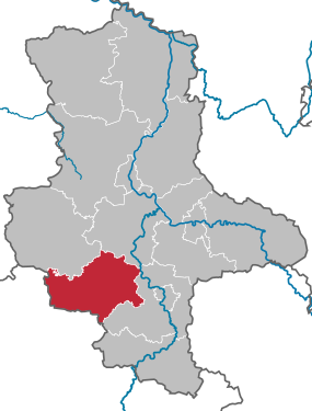
| Location of the district of Mansfeld-Südharz in Saxony-Anhalt | |
  |
|

The district of Mansfeld-Südharz is a regional authority in the southwest of the state of Saxony-Anhalt . It was formed in the course of the district reform on July 1, 2007 by merging the former districts of Mansfelder Land and Sangerhausen .
geography

The north of the district is determined by the Mansfelder Bergland, the easternmost part of the Harz Mountains . At Ulzigerode , the area with the 291 meter high Mahnberg reaches its highest point. To the east, the Harz foreland joins with its almost woodless, flat undulating and varied landscape. In the west, parts of the southern Harz belong to the district, and here, the 580 meter high Großer Auerberg, is the highest point in the district. In the southwest the district closes with the Goldene Aue .
The six square kilometer Kelbra reservoir is located in that fertile lowland area . In the opposite direction on the eastern border of the district, seven kilometers east of Eisleben, there is the three-square-kilometer sweet lake, the second largest body of water in the district. Two rivers cross the district from west to east, the Wipper in the north and the Helme in the south . In the far east of the district, the Saale touches the district area.
Cities and municipalities with the largest population
- Sangerhausen (25,963)
- Lutherstadt Eisleben (23.003)
- Mansfeld Grund-Helbra (14,544)
- Hettstedt (13,885)
- Golden floodplain (9401)
- South Harz (9307)
- Mansfelder Land lake area (8880)
- Mansfeld (8649)
As of December 31, 2019.
Adjacent counties
The district of Mansfeld-Südharz borders in the north on the district of Harz and the Salzland district , in the east on the Saale district , in the south on the Thuringian Kyffhäuserkreis and in the west on the district of Nordhausen .
raw materials
Probably the best known raw material in the district of Mansfeld-Südharz is the copper and silver containing copper slate . This occurs underground in the Mansfelder Mulde and around Sangerhausen and was dismantled on a large scale in the past (see Mansfeld (company) ). After the less deep-lying areas were first excavated in smaller pits, the pits enlarged the more they penetrated into the deeper areas. After the end of the GDR, copper slate mining in the district had to be stopped due to inefficiency.
In the southeastern areas of the district there are larger bodies of salt in the subsoil, the leaching of which once led to the deepening of the Sweet Lake and the Salty Lake . Not far from the district border to Mansfeld Südharz there was a salt mine in Teutschenthal in the Saalekreis for decades that mined these bodies. Recently, however, residues have been filled into the mining cavities in order to prevent underground rockfalls.
What is less well known is that limestone was also mined in some pits in the copper slate area . Limestone occurs sporadically in the district.
At the Hornburger Sattel there are smaller uranium deposits that were explored in the early years of the GDR by the SDAG Wismut . However, due to the insufficient amount of uranium of a few hundred tons, mining was not worthwhile.
Near Amsdorf in the extreme southeast of the district there are lignite deposits containing montan wax. These are mined by the Romonta company in the Amsdorf opencast mine .
A wide distribution of fertile black earth soils in the Mansfeld region is very favorable for agriculture. There are also larger forest areas in the Harz Mountains.
ecology

The southern Harz karst landscape is unique in the world and of great importance for nature conservation and sustainable regional development. It is therefore partially designated as a biosphere reserve.
Protected areas
There are 27 designated nature reserves in the district (as of February 2017).
Historical development

In the course of the Middle Ages, several systems of rule were established in the area of the district. The county of Mansfeld had the largest share, including the cities of Hettstedt , Lutherstadt Eisleben and Gerbstedt . The county existed until the family died out in 1780 and then became part of Electoral Saxony or Prussia, in 1807/1808 for the most part to the Kingdom of Westphalia ( Saale Department ) and in 1815 to Prussia . Another family of counts ruled the west of the district from 1210, the Counts of Stolberg . The area of today's municipality of Südharz belonged to the county of Stolberg , as well as further south, together with the Counts of Schwarzburg, the places Kelbra and Tilleda . In 1738/1740 the county of Stolberg came under the rule of the Electorate of Saxony , which was replaced by Prussia in 1815.
In the far north, Sandersleben belonged to the Anhalt principalities, from 1918 to 1945 to the Free State of Anhalt. The cities of Sangerhausen and Allstedt were subject to changing rulers . Sangerhausen has belonged to the Brandenburg margraves since 1291 , became the property of the Duchy of Braunschweig in 1340 and came under the Wettin-Saxon rule in 1372 . The Saxon period, between 1656 and 1748 Duchy of Saxony-Weißenfels , ended in 1815 with the takeover by Prussia.
Allstedt was mentioned in 1299 as the bailiwick of the county of Beichlingen. In 1320 Allstedt was given as an imperial fiefdom to various mansions, including Mansfeld, Anhalt and Saxony. It was not until 1575 that the Ernestines exercised unrestricted rule over the Allstedt office . From 1815 to 1945 the area around Allstedt was a Thuringian exclave in Prussia (1815–1920: Sachsen-Weimar-Eisenach ). The rest of today's district, with the exception of Sandersleben and Tilkerode, had been in Prussian hands since 1815 as a result of the Congress of Vienna .
Of the Prussian districts that were newly established up to 1818, the Mansfeld Mountain District , the Mansfeld Lake District and the District of Sangerhausen formed the current district area. This division essentially remained in place until 1994, with parts of the Mansfeld districts and the Eisleben district , which had existed since 1908, forming the Eisleben district in 1950 , which was divided into the Hettstedt and Eisleben districts in 1952 . During the first district reform in Saxony-Anhalt in 1994, the districts of Hettstedt and Eisleben were merged to form the district of Mansfelder Land.
Population development


The State Statistical Office of Saxony-Anhalt published figures on the population development of the regional units in the district. The population figures for different years were calculated for the respective territorial status from 2014. In the data, a different development of the individual cities and municipalities can be seen. The towns of Sangerhausen and Hettstedt grew until the fall of the Berlin Wall, with the construction of new blocks at the same time. After the collapse of the GDR, however, they lost about a third of the population. The city of Lutherstadt Eisleben, on the other hand, has experienced a population decline since at least the 1960s. She lost about half of the population. In the unified communities in the former old district of Mansfelder Land there is a development analogous to Lutherstadt Eisleben: The number of inhabitants has decreased by around half since the 1960s. In the large unified communities of the old district of Sangerhausen, the population has also been shrinking since the 1960s, albeit less sharply than in the Mansfeld region.
| year | Sangerhausen | Eisleben | Hettstedt |
|---|---|---|---|
| 1964 | 38,640 | 44,773 | 19,957 |
| 1989 | 43,823 | 35,374 | 22,559 |
| 2000 | 35,167 | 29,526 | 18,976 |
| 2010 | 29,679 | 25,489 | 15,343 |
| 2017 | 26,798 | 23,651 | 14,265 |
economy
The district of Mansfeld-Südharz is one of the economically weakest regions in the state of Saxony-Anhalt. The unemployment rate in the district is above average in a national comparison of 8.7% (as of 10/2019). However, it has been falling for a few years. In October 2016 it was still 11.2%.
After the decline of copper mining and aluminum smelting in the Mansfeld area, new branches of industry developed: at Klemme AG in Eisleben and in Hettstedt at the Mansfeld copper and brass works (KME Mansfeld GmbH) , a successor company to the traditional VEB Mansfeld , jobs were created to a certain extent . Another traditional company, the MIFA Mitteldeutsche Fahrradwerke in Sangerhausen, had to file for bankruptcy in 2014 and again in 2017 after years of losses. At Amsdorf there is still the Amsdorf opencast mine ; Romonta GmbH's montan wax factory there covers 80% of the world's montan wax demand . In the wooded western region of the district, forestry is practiced, in the eastern half, however, predominantly agriculture. The Harz regions and the Luther cities of Eisleben and Mansfeld are increasingly benefiting from tourism . Location Marketing Mansfeld-Südharz GmbH acts as a contact for investors and settlements in the district of Mansfeld-Südharz.
Due to the mild climate for these latitudes, grapes are grown on the Süßen See for wines belonging to the Saale-Unstrut region ( Mansfeld Lakes area ). The main growing area of this region is, however, further southeast in the neighboring counties. Furthermore, beer is brewed in a brewery in Wippra in the Harz Mountains ( Wippraer ).
Future Atlas 2016 ranked the district of Mansfeld-Südharz 400th out of 402 districts, municipal associations and independent cities in Germany and is therefore one of the regions with "very high future risks".
Traffic routes
Motorway connections
,_Autobahn,_Blick_nach_Einsdorf.jpg)
The district of Mansfeld-Südharz is connected to the Kassel / Göttingen regions in the west and the Halle / Leipzig region in the east via the A 38 motorway . It runs for approx. 46 km through the district area. There is also a connection from Sangerhausen with the A 71 to Erfurt in the south, which runs for approx. 4.9 km over the district area. The Plötzkau junction on the A 14 is not far from the district border in the north-east , via which, in addition to Halle and Leipzig, the Saxony-Anhalt state capital Magdeburg can be reached. Finally, the A 36 leads past the northern edge of the district near Aschersleben . In addition to the northern Harz region, the cities of Braunschweig and Hanover in Lower Saxony can also be reached via these .
Federal highways
The following federal highways run in the district:
- B 80 for approx. 13 km
- B 85 for about 6.3 km
- B 86 for approx. 36 km
- B 180 for approx. 40 km
- B 242 (Harzhochstraße) for approx. 25 km
Railway lines

The remaining railways are of regional importance:
- Railway line Halle – Hann. Münden for almost 65 km
- Railway line Berlin – Blankenheim for approx. 26 km
- Sangerhausen – Erfurt railway line for just under 5 km
- Halle – Vienenburg railway line for just under 4.5 km
The larger railway lines touch at two junctions. At the train station in Sangerhausen there are connections with the regional express to Erfurt and Magdeburg on one route and Halle (Saale), Eisleben, Nordhausen and Kassel on another. The Sandersleben train station is also on the railway line, which enables rail connections with the regional express to Erfurt and Magdeburg. From there there are other railway lines to Halle and in the northern Harz to Aschersleben, Quedlinburg , Halberstadt and Goslar .
The narrow-gauge Mansfeld mining railway and the Klostermansfeld – Wippra (“Wipperliese”) railway are also used purely for tourism . Both routes are served by historic vehicles.
Hospitals
In the district of Mansfeld-Südharz there are Helios clinics in Hettstedt, Lutherstadt Eisleben and Sangerhausen. All three clinics are basic providers .
education
In the district of Mansfeld-Südharz there are 39 primary schools, nine secondary schools, four grammar schools, one vocational school and six special schools. In Eisleben there used to be a university (1798 to 1968 Bergschule Eisleben , 1968 to 1993 Engineering School Eisleben ), but it was closed in the early 1990s.
politics
Mansfeld-Südharzer Kreisag 2019
- Left : 8
- SPD : 7
- Greens : 2
- WG fire department Mansfeld-Südharz: 1
- FDP : 3
- Regional : 1
- FBM : 4
- FWG Goldene Aue : 1
- FFw Mansfelder Land: 1
- CDU : 9
- Farmers' Union : 2
- AfD : 9
District Administrator
The first district administrator was Dirk Schatz , who won a runoff election on May 6, 2007 with 52.89% to 47.11% of the votes against his competitor Frank Bayer (SPD).
Schatz was replaced on July 16, 2014 by Angelika Klein (left). A month earlier she had received 80.6% of the vote in a runoff election against the incumbent.
District council
(Result of the local elections on May 26, 2019)
| Parties and constituencies | Percent 2019 |
Seats 2019 |
Percent 2014 |
Seats 2014 |
Percent 2007 |
Seats 2007 |
Percent 2004 |
Percent 1999 |
|
|---|---|---|---|---|---|---|---|---|---|
| AfD | Alternative for Germany | 19.3 | 9 | - | - | - | - | - | - |
| CDU | Christian Democratic Union of Germany | 19.0 | 9 | 28.3 | 14th | 30.7 | 17th | 35.9 | 37.1 |
| left | The left | 15.9 | 8th | 27.0 | 13 | 22.0 | 12 | 22.3 | 18.6 |
| SPD | Social Democratic Party of Germany | 14.4 | 7th | 16.6 | 8th | 21.3 | 12 | 19.0 | 26.5 |
| FBM | Free citizens of Central Germany | 9.3 | 4th | 5.2 | 3 | - | - | - | - |
| FDP | Free Democratic Party | 5.1 | 3 | 6.0 | 3 | 9.8 | 5 | 10.5 | 5.9 |
| Farmers association | Farmers' Association Mansfeld-Südharz | 3.9 | 2 | 3.5 | 2 | 2.6 | 1 | 2.0 | 2.0 |
| Green | Alliance 90 / The Greens | 3.3 | 2 | 2.9 | 1 | 1.6 | 1 | 1.0 | 1.8 |
| Regional | The regional Mansfeld-Südharz | 2.5 | 1 | 1.3 | 1 | - | - | - | - |
| FFw ML | Mansfelder Land volunteer fire department | 2.4 | 1 | - | - | - | - | - | - |
| WG GA | Free voter community Goldene Aue | 2.0 | 1 | - | - | - | - | - | - |
| WGF | Voting community fire brigade Mansfeld-Südharz | 1.2 | 1 | 0.8 | 0 | - | - | - | - |
| Flat share FLE | Lutherstadt Eisleben Fire Brigade voter community | 0.8 | 0 | - | - | - | - | - | - |
| FWG MSH | Free voter community Mansfeld-Südharz | 0.3 | 0 | 6.9 | 3 | - | - | - | - |
| HKV | Heimat- und Kulturverein Hedersleben e. V. | - | - | 0.6 | 0 | - | - | - | - |
| NPD | National Democratic Party of Germany | - | - | - | - | 4.2 | 2 | - | - |
| FWJS | Free electorate, youth and sport | - | - | - | - | 3.7 | 2 | 5.1 | 2.3 |
| VS MS | People's solidarity Mansfeld-Südharz | - | - | - | - | 1.2 | 1 | - | - |
| VS Sgh | People's solidarity Sangerhausen | - | - | - | - | 0.9 | 1 | 1.0 | 1.2 |
| WASG | Elective alternative social justice | - | - | - | - | 0.5 | 0 | - | - |
| EB | Individual applicants | 0.6 | 0 | - | - | 1.6 | 0 | 0.3 | 0.8 |
| Otherwise. | Others | - | - | - | - | - | - | 2.9 | 3.9 |
| total | 100 | 48 | 100 | 48 | 100 | 54 | 100 | 100 | |
| Turnout in percent | 45.6 | 34.7 | 43.9 | 53.6 | |||||
- EB: Individual applicants 2007: Gerald Kästner (0.7%), Horst Tetzel (0.5%), Hartmut Reinicke (0.4%); 2004: Hartmut Reinicke; 1999: k. A.
- The results from 1999 and 2004 were converted to the 2007 territorial status.
The following parliamentary groups were formed in the district council (as of May 1, 2020): CDU parliamentary group (9 members), parliamentary group FB (9 members), parliamentary group SPD / The Greens (9 members), AfD parliamentary group (8 members), parliamentary group DIE LINKE (8 members), FDP parliamentary group (4 members). Non-attached: 1 member.
coat of arms
The coat of arms was approved on March 17, 2008 by the Ministry of the Interior of Saxony-Anhalt.
Blazon : “Half split and divided; front of the top quartered, field 1 and 4: six times silver divided over red; Field 2 and 3: in silver six (3: 3) red diamonds; at the top in silver a stylized natural red rose; at the bottom a silver triangle in green, covered with a diagonally crossed black tooth (miner's tooth). "
The coats of arms of the administrative communities, cities and municipalities of the district are in the list of coats of arms in the district of Mansfeld-Südharz .
flag
The flag is green and white (1: 1) striped (horizontal shape: stripes running horizontally, lengthways shape: stripes running vertically) and in the middle with the district coat of arms.
Award
On May 25, 2009, the district received the title “ Place of Diversity ” awarded by the federal government .
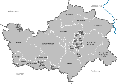
Communities


Unified municipalities
(cities arehighlighted in bold )
(* seat of the district)
| coat of arms | local community | Residents | Area in km² |
|---|---|---|---|
|
|
Allstedt | 7685 | 149.81 |
|
|
Arnstein | 6553 | 121.69 |
|
|
Gerbstedt | 7072 | 102.31 |
|
|
Hettstedt | 13,885 | 36.93 |
|
|
Lutherstadt Eisleben | 23.003 | 143.87 |
|
|
Mansfeld | 8649 | 143.79 |
|
|
Sangerhausen * | 25,963 | 207.66 |
|
|
Mansfelder Land lake area | 8880 | 107.92 |
|
|
South Harz | 9307 | 236.38 |
Association communities with their member communities
(* seat of the association community)
| coat of arms | Member parish | Residents | Area in km² |
|---|---|---|---|
|
|
Berga | 1658 | 25.67 |
|
|
Bridge chopping puddles | 982 | 16.65 |
|
|
Edersleben | 960 | 9.06 |
|
|
Kelbra (Kyffhäuser) * | 3335 | 40.55 |
|
|
Wallhausen | 2466 | 35.34 |
| coat of arms | Member parish | Residents | Area in km² |
|---|---|---|---|
|
|
Ahlsdorf | 1561 | 5.09 |
|
|
Benndorf | 2033 | 5.77 |
|
|
Blankenheim | 1159 | 14.86 |
|
|
Bornstedt | 793 | 9.31 |
|
|
Helbra * | 3986 | 9.26 |
|
|
Hergisdorf | 1580 | 9.54 |
|
|
Klostermansfeld | 2306 | 8.82 |
|
|
Wimmelburg | 1126 | 8.56 |
Territory changes
Changes at the community level
Church planting
- Dissolution of the communities of Brücken (Helme) and Hackpfüffel - re-establishment of the community of Brücken-Hackpfüffel (January 1, 2009)
- Dissolution of the municipalities of Amsdorf , Aseleben , Erdeborn , Hornburg , Lüttchendorf , Neehausen , Röblingen am See , Seeburg , Stedten and Wansleben am See - re-establishment of the municipality of Seegebiet Mansfelder Land (January 1, 2010)
- Dissolution of the municipalities of the city of Gerbstedt, Augsdorf , Friedeburgerhütte , Hübitz , Ihlewitz , Rottelsdorf , Siersleben , Welfesholz and Zabenstedt - the city of Gerbstedt is re-established (January 1, 2010)
- Dissolution of the municipalities City of Sandersleben (Anhalt) , Alterode , Bräunrode , Greifenhagen , Harkerode , Quenstedt , Stangerode , Sylda , Ulzigerode and Welbsleben - re-establishment of the City of Arnstein (January 1, 2010)
- Dissolution of the municipalities Bennungen , Breitenstein , Breitungen , Dietersdorf , Drebsdorf , Hainrode , Hayn (Harz) , Kleinleinungen , Questenberg , Roßla , Rottleberode , Schwenda and Uftrungen - reestablishment of the southern Harz municipality (January 1, 2010)
Incorporations
- Dissolution of the municipality of Wippra - incorporation into Sangerhausen (January 1, 2008)
- Dissolution of the communities of Bischofrode , Osterhausen and Schmalzerode - incorporation into Lutherstadt Eisleben (January 1, 2009)
- Dissolution of the communities of Abberode , Braunschwende , Friesdorf , Hermerode , Molmerswende and Ritzgerode - incorporation into Mansfeld (March 6, 2009)
- Dissolution of the municipality of Tilleda - incorporation into Kelbra (July 1, 2009)
- Dissolution of the communities Martinsrieth and Riethnordhausen - incorporation into Wallhausen (July 1, 2009)
- Dissolution of the communities of Burgsdorf and Hedersleben - incorporation into the city of Lutherstadt Eisleben (January 1, 2010)
- Dissolution of the municipalities of Beyernaumburg , Emseloh , Holdenstedt , Katharinenrieth , Liedersdorf , Mittelhausen , Niederröblingen (Helme) , Nienstedt , Pölsfeld , Sotterhausen and Wolferstedt - incorporation into the city of Allstedt (January 1, 2010)
- Dissolution of the communities of Freist , Friedeburg (Saale) and Heiligenthal - incorporation into Gerbstedt (January 24, 2010)
- Dissolution of the communities of Arnstedt and Wiederstedt - incorporation into Arnstein (September 1, 2010)
- Dissolution of the municipality of Dederstedt - incorporation into the Mansfelder Land lake area (September 1, 2010)
- Dissolution of the communities of Ritterode and Walbeck - incorporation into Hettstedt (September 1, 2010)
- Dissolution of the city of Stolberg (Harz) and the municipality of Wickerode - incorporation into the southern Harz (September 1, 2010)
- Dissolution of the Winkel municipality - incorporation into Allstedt (September 1, 2010)
Changes in administrative communities and association communities
- Dissolution of the administrative community Allstedt-Kaltenborn (January 1, 2010)
- Dissolution of the administrative community Mansfelder Grund-Helbra (January 1, 2010)
- Re-establishment of the association community Mansfelder Grund-Helbra (January 1, 2010)
- Dissolution of the administrative association Goldene Aue
- Re-establishment of the association community Goldene Aue (January 1, 2010)
- Dissolution of the administrative community Seegebiet Mansfelder Land (January 1, 2010)
- Dissolution of the Gerbstedt administrative community (January 1, 2010)
- Dissolution of the administrative community Wipper-Eine (January 1, 2010)
- Dissolution of the administrative community Roßla-Südharz (January 1, 2010)
- Dissolution of the administrative community Hettstedt (September 1, 2010)
License Plate
On October 1, 2007, the district was assigned the distinctive sign MSH . Until then the identifiers ML (Mansfelder Land) and SGH (Sangerhausen) were used. These and the distinctive signs EIL (Eisleben) and HET (Hettstedt) have been available (again) since November 29, 2012.
Web links
- Website of the district of Mansfeld-Südharz
- Location marketing Mansfeld Südharz GmbH
- The Biosphere Reserve Karstlandschaft Südharz in the Mansfeld-Südharz district
- The southern Harz karst hiking trail
Individual evidence
- ↑ State Statistical Office Saxony-Anhalt, population of the municipalities - as of December 31, 2019 (PDF) (update) ( help ).
- ^ Martin Spilker: 800 years of copper slate mining in Mansfeld. Text for the 12th Südharz Symposium on March 6, 2010 in Wettelrode ( online ), accessed on November 22, 2019.
- ↑ State Office for Archeology and Monument Preservation Saxony-Anhalt: August: The Mansfeld Haldenlandschaft online , accessed on November 22, 2019.
- ↑ State Office for Geology and Mining Saxony-Anhalt: Geological surface map 1: 400,000 without Quaternary ( online ), accessed on November 22, 2019.
- ↑ Dr. Rudolf Mirsch: The secret of activities on the Hohenthalschacht in 1949/1950. In: Article by VMBH eV in Mansfeld-Echo, 2000 - 2 to 4. Also available online at https://www.kupferspuren.eu/ , accessed on November 22, 2019.
- ↑ State Office for Geology and Mining Saxony-Anhalt: Geological surface map 1: 400,000 ( online ), accessed on November 22, 2019.
- ↑ census database
- ↑ StaLA DE-ST: Population development of the lake area Mansfelder Land
- ↑ Stala DE-ST: Population development of Mansfeld
- ↑ Stala DE-ST: Population development of Gerbstedt
- ↑ Stala DE-ST: Population development of Arnstein
- ↑ Stala DE-ST: Population development of Südharz
- ↑ Stala DE-ST: Population development of Allstedt
- ↑ Stala DE-ST: Population development of Sangerhausen
- ↑ Stala DE-ST: Population development of Eisleben
- ↑ Stala DE-ST: Population development of Hettstedt
- ↑ Federal Employment Agency: Statistics , for the district of Mansfeld-Südharz, accessed on November 16, 2019.
- ↑ Website of the community Seegebiet Mansfelder Land : Wineries in the Seegebiet, accessed on November 21, 2019.
- ↑ Future Atlas 2016. (No longer available online.) Archived from the original on October 2, 2017 ; accessed on March 23, 2018 .
- ↑ Local transport company Saxony-Anhalt (nasa): Route network map 2019 (pdf, online) , 1.7 MB, accessed on November 21, 2019.
- ↑ https://www.mansfeldsuedharz.de : Schools and school transport in general, accessed on November 21, 2019.
- ↑ Official final result on Wahlresults.sachsen-anhalt.de
- ↑ Official final result on Wahlresults.sachsen-anhalt.de
- ↑ statistik.sachsen-anhalt.de ( Memento from March 4, 2016 in the Internet Archive ) Result of the 2014 district election.
- ↑ statistik.sachsen-anhalt.de ( Memento from September 8, 2014 in the Internet Archive ) Results of the district council elections 1999–2007.
- ↑ a b State Administration Office of Saxony-Anhalt (Ed.): Official Journal . 5th year, no. 8 . Halle (Saale) May 15, 2008, p. 137 ( lvwa.sachsen-anhalt.de [PDF; 235 kB ; accessed on December 1, 2015]). Official Journal ( Memento of December 8, 2015 in the Internet Archive )
- ↑ a b c State Statistical Office Saxony-Anhalt, population of the municipalities - as of December 31, 2019 (PDF) (update) ( help on this ).
- ↑ a b c regionalstatistik.de Regional database of the Federal Statistical Office (as of December 31, 2016)
Altmarkkreis Salzwedel | Anhalt-Bitterfeld | Börde | Burgenland District | Dessau-Roßlau | Halle (Saale) | Resin | Jerichower Land | Magdeburg | Mansfeld-Südharz | Saalekreis | Salzlandkreis | Stendal | Wittenberg