
Hayn (Harz)
|
Hayn (Harz)
South Harz municipality
Coordinates: 51 ° 34 ′ 10 ″ N , 11 ° 4 ′ 32 ″ E
|
|
|---|---|
| Height : | 438 m above sea level NHN |
| Area : | 20.04 km² |
| Residents : | 557 (2010) |
| Population density : | 28 inhabitants / km² |
| Incorporation : | January 1, 2010 |
| Postal code : | 06536 |
| Area code : | 034658 |
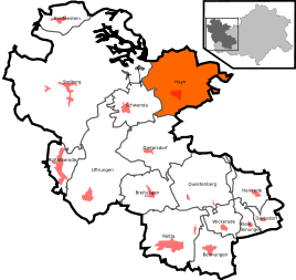  Location of Hayn (Harz) in the southern Harz
|
|
 View of Hayn from the Josephskreuz
|
|
Hayn (Harz) is a district of the municipality of Südharz in the district of Mansfeld-Südharz in Saxony-Anhalt .
Geographical location
Hayn is located in the southern Harz on the country road that leads from Harzgerode in a southerly direction through the mountains to Roßla .
history
.jpg)
Hayn belonged to the estate of the Counts of Stolberg and was the seat of its own office in the County of Stolberg-Stolberg . Until 1815 Hayn belonged to the Electorate of Saxony and then came to the Merseburg administrative district of the Prussian province of Saxony .
From 1952 to 1990 Hayn was part of the GDR district of Halle .
On January 1, 2010 the communities Hayn (Harz), Breitenstein , Breitungen , Dietersdorf , Drebsdorf , Hainrode , Bennungen , Kleinleinungen , Questenberg , Roßla , Rottleberode , Schwenda and Uftrungen merged to form the new community Südharz. At the same time, the Roßla-Südharz administrative community , to which Hayn (Harz) belonged, was dissolved.
Sons and daughters of the place
- Eustasius Friedrich Schütze (1688–1758), Protestant theologian
- Emil Baumecker (1866–1947), Evangelical Lutheran pastor in Leopoldshall and member of the state parliament of the Free State of Anhalt
- Wolfgang Bartels (1890–1971), socialist politician and journalist
Web links
- Description of the village on gemeinde-suedharz.de