Huebitz
|
Huebitz
City of Gerbstedt
Coordinates: 51 ° 35 ′ 49 ″ N , 11 ° 33 ′ 15 ″ E
|
|
|---|---|
| Height : | 216 m above sea level NHN |
| Area : | 3.83 km² |
| Residents : | 336 (Dec. 31, 2009) |
| Population density : | 88 inhabitants / km² |
| Incorporation : | January 1, 2010 |
| Postal code : | 06347 |
| Area code : | 03476 |
|
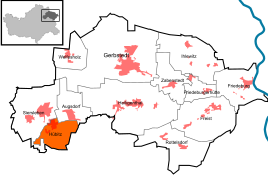
Location of Hübitz in Gerbstedt
|
|
Hübitz is a district of the city of Gerbstedt in the district of Mansfeld-Südharz in Saxony-Anhalt .
geography
The place is about eight kilometers north of Lutherstadt Eisleben and six kilometers south of Hettstedt on both slopes of a hollow in the Mansfelder Platte landscape . The Grift stream begins in the village pond in the center of the village . This then runs underground through the sewer system and only emerges in the east of the village at the intersection of Breite Straße and Griftweg . From here it flows on through a several meters deep indentation stretching to Augsdorf in the east, in which there used to be many orchards. Originally, there was the so-called. Apple Born a headwaters of Grifts, the west flowing not from farther from the direction of the business park apple Born. Its trench usually no longer has any water. The large copper slate dump of the former Ernst-Thälmann-Schacht, which can be seen as a landmark from a great distance, is in the southern Hübitz district.
Hübitz, together with Siersleben , Thondorf and Augsdorf are also referred to as the Griftdörfer or as the villages on the Griftbach . The village's landmark is the St. Matthias Church, consecrated in 887 and recently partially renovated, with a restored clock tower.
history
Like Siersleben, Hübitz used to be a Rundling, which presumably extended around the village pond.
According to old records, there were also two Hübitzes in the past.
On January 1, 2010 the communities of Hübitz, Augsdorf , Friedeburgerhütte , Ihlewitz , Rottelsdorf , Siersleben , Welfesholz and Zabenstedt merged with the city of Gerbstedt to form the new city of Gerbstedt . The Gerbstedt administrative community , to which Hübitz belonged, was dissolved.
After the incorporation to Gerbstedt, some streets were renamed. The aim of the renaming was the abolition of duplicate street names in various localities in the new city of Gerbstedt. Old names, some of which date back to the time before the reunification, such as the street of DSF (German-Soviet friendship) were replaced by newer ones.
traffic
To the federal highway 180 which connects Eisleben and Hettstedt , it is approx. 1 km to the west.
The closest train station is in Hettstedt.
The next motorway exit is on the A 14 near Plötzkau .
education
The nearby primary school in Siersleben is repeatedly threatened with closure due to a just barely reached minimum number of students prescribed by the state. A comprehensive school is located in Benndorf , the next high school is in Hettstedt.
literature
- Erich Neuss : "Hikes through the County of Mansfeld"; Volume 3, In the Heart of the County Fly Head Verlag, Halle (Saale), 2001
Web links
- Hübitz on the website of the unified municipality of the city of Gerbstedt
- Website of the former administrative association
- www.huebitz.de
Individual evidence
- ↑ State Office for Surveying and Geoinformation Saxony-Anhalt: Saxony-Anhalt Viewer . Can be found online at: https://lvermgeo.sachsen-anhalt.de , accessed on: April 23, 2019.
- ^ Website of the Evangelical Church District Eisleben-Sömmerda (online) , accessed on April 23, 2019.
- ↑ StBA: Area changes from January 01 to December 31, 2010
- ^ City of Gerbstedt: Official Gazette . Edition 6/2010. Available online in the municipal gazette archive.
- ↑ Wolfram Bahn: Primary schools in Mansfeld-Südharz Verbund is the magic word . Published online at https://mz-web.de on April 28, 2014.
- ^ Felix Fahnert: Primary school Siersleben, closure after petition averted for the time being . Published online at https://mz-web.de on March 26, 2019.


