
Augsdorf (Gerbstedt)
|
Augsdorf
City of Gerbstedt
Coordinates: 51 ° 36 ′ 0 ″ N , 11 ° 34 ′ 0 ″ E
|
|
|---|---|
| Height : | 188 m above sea level NHN |
| Area : | 4.51 km² |
| Residents : | 573 (Dec. 31, 2009) |
| Population density : | 127 inhabitants / km² |
| Incorporation : | January 1, 2010 |
| Postal code : | 06347 |
| Area code : | 03476 |
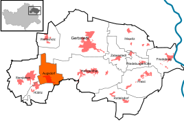  Location of Augsdorf in Gerbstedt
|
|


Augsdorf is a district of the city of Gerbstedt in the district of Mansfeld-Südharz in Saxony-Anhalt . Augsdorf, Thondorf , Hübitz and Siersleben are also referred to as the Griftdörfer (villages on the Griftbach ).
geography
Augsdorf is located on an undulating low mountain plateau , the so-called Mansfelder Platte , approx. 6 km southeast of Hettstedt . In the local area there are two valley cuts in this slab, that of the Rüsterbach from Siersleben , which begins west of the village as a small valley and only becomes deeper in the locality, and that of the Grift from Hübitz , which comes from the west as a deeper valley. The former valley turns south in the village center of Augsdorf and flows into the latter at the outdoor pool. Both valleys border a hill on three sides, on this hill is the village church, to the north and east of the village church is the old street village center of Augsdorf, from here a newer residential area extends almost to the Griftbach. The streets here are laid out in a grid. South of Augdorf is the Pollebener Cave , which is used as a sledge mountain in winter , the edge of the basin at the outdoor pool is interrupted here by a small sine cut through which the agricultural path leads to the road from Hübitz to Polleben . There are also some small ponds in this poorly built-up basin. The valley of the Rüsterbach leads out of the basin; it leaves Augsdorf towards the east after the Grift flows into it. Then it leads to the large heap of the Otto Brosowski shaft . The Augsdorf district ends here. North of the village the landscape is not so varied, it is dominated by fields and is flat except for the valley of the Sohlbach. The Nienstedt village village is located in this valley .
Augsdorf is not very well connected to the traffic, a state road, the L154 ( Siersleben - Könnern ) leads north past the place.
climate
The annual precipitation is 498 mm. The rainfall is extremely low. They are in the lower twentieth of the values recorded in Germany. Lower values are registered at 3% of the measuring stations of the German Weather Service . The driest month is October, with the most rainfall in June. In June there is 1.9 times more rainfall than in October. Precipitation hardly varies and is evenly distributed over the year. Lower seasonal fluctuations are recorded at only 16% of the measuring stations .
history
- Settlement of the area around Augsdorf in prehistoric times is documented by the prince grave of Helmsdorf .
- The village of Augsdorf was probably created around 850 during the Franconian colonization.
- the place was originally a street village on the old road between Siersleben and Helmsdorf. Today this old road only exists west of Augsdorf as a connection route to Siersleben.
- The chronicler Spangenberg believes in 1570 that the inhabitants of Augsdorf were still called citizens around 1300 and enjoyed civil liberties, which means that Augsdorf was much more important then than it is today.
On January 1, 2010, the communities of Augsdorf, Friedeburgerhütte , Hübitz , Ihlewitz , Rottelsdorf , Siersleben , Welfesholz and Zabenstedt merged with the city of Gerbstedt to form the new city of Gerbstedt . The Gerbstedt administrative community , to which Augsdorf belonged, was dissolved.
After the incorporation, a few streets were renamed from the new town of Gerbstedt to Augsdorf, so that there were no double street names in different localities.
Culture and sights
Historical monuments
- Grave stone on the local cemetery for an individual known Polish forced laborers , who as a prisoner from the nearby Paul Schacht had in 1943 and was forced labor killed
Economy and Infrastructure
traffic
To the federal highway 180 which connects Querfurt and Hettstedt, it is about two kilometers to the west. The closest train station is in Hettstedt.
Individual evidence
- ↑ State Office for Surveying and Geoinformation Saxony-Anhalt: Saxony-Anhalt Viewer. Can be found online at: https://lvermgeo.sachsen-anhalt.de , accessed on: April 22, 2019.
- ↑ StBA: Area changes from January 01 to December 31, 2010
- ^ City of Gerbstedt: Official Gazette . Edition 6/2010. Available online in the municipal gazette archive.
literature
- Erich Neuss: "Walks through the County of Mansfeld"; Volume 3, In the Heart of the County . fly head publishing house, Halle (Saale), 2001
Web links
- https://stadt-gerbstedt.de/ - Augsdorf on the website of the unified municipality of the city of Gerbstedt.
- http://augsdorf-online.de/ - Infoportal about the village Augsdorf - current and local history.

Locations: Augsdorf | Free | Friedeburg (Saale) | Friedeburgerhütte | Gerbstedt (village) | Heiligenthal | Hübitz | Ihlewitz | Rottelsdorf | Siersleben | Welfesholz | Zabenstedt
Districts: Adendorf | Bösenburg | Elves | Helmsdorf | Lochwitz | Oeste | Pfeiffhausen | Strausshof | Thaldorf | Thondorf | Zabitz