Mansfeld plate
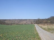
The Mansfelder Platte is a landscape in the district of Mansfeld-Südharz in southern Saxony-Anhalt . It is named after the small town of Mansfeld , which lies on the western edge of the plate.
geography
Similar to the larger Querfurter Platte in the south, it is a plateau around 200 m high and is bounded by the Saale - and the Salzatal in the east, the Riss , or the Eisleben lowland in the south and the Mansfelder Grund , the Regenbeck (the valley the creek Alte Wipper , which flows from Klostermansfeld in the south to Hettstedt in the north) and the valley of the Wipper from Hettstedt to Sandersleben in the west.
In terms of natural space , it is assigned to the main unit of the Eastern Harz foreland according to the handbook of the natural spatial structure of Germany .
Mountains and elevations

The most important mountains and elevations are on the Mansfelder Platte:
- nameless mountain (255.4 m), east of Klostermansfeld
- nameless mountain (228.3 m), northwest of Siersleben
- Schalkberg (226.2 m), between Hedersleben and Wormsleben
- nameless knoll (190.9 m), east of Rottelsdorf
- Langer Hu (190.7 m), east of Gerbstedt
The highest point in the landscape is an artificially created spoil dump west of Polleben with a height of around 350 meters.
nature
The undulating Mansfelder Platte flattens out somewhat to the north and east. It is mainly used for agriculture. Several streams arise on it, which have springs rich in water (e.g. the Rotewelle near Welfesholz) or arise directly on the plateau (e.g. the Lobach near Gerbstedt ). One cause could be the nearby Harz Mountains , from which water appears to be drawn here through underground layers. Otherwise, the landscape is mostly drained in an easterly direction ( Laweke , Schlenze with the Fleischbach and the Lohbach ) to the Saale.
Special
- In the past, copper slate was mined near Volkstedt , Polleben and Augsdorf , and several large spoil heaps are still in the landscape today.
- It is named after the city of Mansfeld , which, however, was not on the plate itself.
- An administrative community called itself after the Mansfelder Platte, the Verwaltungsgemeinschaft Mansfelder Platte , which was dissolved in 2005.
Individual evidence
- ^ E. Meynen and J. Schmithüsen : Handbook of the natural spatial structure of Germany (6th delivery 1959) - Federal Institute for Regional Studies, Remagen / Bad Godesberg 1953–1962 (9 deliveries in 8 books, updated map 1: 1,000,000 with main units 1960)
- ↑ Map services of the Federal Agency for Nature Conservation ( information )

