Slap
| Slap | ||
|
Course of the Schlenze (from left to right) |
||
| Data | ||
| location | between Polleben and Friedeburg in the district of Mansfeld-Südharz | |
| River system | Saale | |
| Drain over | Saale → Elbe → North Sea | |
| source | Rulsdorf desert 51 ° 34 ′ 27 ″ N , 11 ° 35 ′ 29 ″ E |
|
| muzzle |
Saale bei Friedeburg Coordinates: 51 ° 37 '16 " N , 11 ° 44' 54" E 51 ° 37 '16 " N , 11 ° 44' 54" E |
|
| Height difference | 120 m | |
| Bottom slope | 8th ‰ | |
| length | 15 km | |
| Left tributaries | Lobach , Ristebach | |
| Right tributaries | Fleischbach | |
| Communities | Eisleben , Gerbstedt | |
| Navigable | not at all | |
|
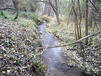
The Schlenze in the forest near Helmsdorf |
||
The Schlenze is a 15 km long stream in the district of Mansfeld-Südharz . It arises south of Polleben near the Rulsdorf desert and flows into the Saale near Friedeburg , to whose river system it belongs.
Origin of name
There are two theories about the origin of the name. One relates to unspecified documentary evidence as Silenza . This is derived from the Silingi , which indicates a settlement of this tribe in Mansfeld . The same river names in Silesia would indicate this. The second theory is based on the fact that corresponding rivers are not comparable with the Schlenze. Therefore, the name could have originated from the z in Schlen z e through Zetazism from the k in the Low German Schlen k e (curvature of a stream).
course
Places on the stream
- Polleben 0 km
- Helmsdorf 4.2 km
- Heiligenthal 5.3 km
- Lochwitz 6.5 km
- Zabenstedt 8.3 km
- Friedeburgerhütte 9.2 km
- Adendorf 10.9 km
- Friedeburg 14.7 km
Tributaries
The largest tributaries are the Ristebach from Siersleben near Helmsdorf , the Sohlbach from the Nienstedt desert near Heiligenthal , the Lobach from Gerbstedt near Zabenstedt and the Fleischbach from Bösenburg at the Freist sewage treatment plant . In addition, a few rivulets flow into the Schlenze: in Polleben the Danube, one near Heiligenthal, one near Zabenstedt, a larger one from Ihlewitz near Friedeburgerhütte , a smaller one near Adendorf and one near Friedeburg .
history
- Around 1400 the water is called Slenz . The name is believed to be of Slavic origin.
- Cyriacus Spangenberg called the arm of the Lobach estuary near Zabenstedt coming from Heiligenthal as Schleinitz .
particularities
- The source of the Schlenze is today an artesian well about one meter high . This stands next to a dried up ditch and the discharge from the well flows into the ditch.
- Two railway lines crossed the course of the Schlenze. On the one hand, the Halle Klaustor – Hettstedt railway line at Polleben . The section on which the Schlenzebrücke was located was closed on March 11, 1968. There was also the Gerbstedt – Friedeburg branch line , built in 1899/1900 , which bridged the Schlenze in Zabenstedt and from there ran parallel to the brook to Friedeburg. It was shut down in 1962 and dismantled in 1974.
- The current course of the stream was not always completely considered a Schlenze, at different times different streams were known as the upper course of the river. These were, for example, the Sohlbach and the Lobach. This is due to the fact that these streams, now rivulets, used to carry considerably more water. It is unclear which part of these waters was the true upper reaches of the Schlenze. The Pollebener Mühlenbach , as today's upper course of the Schlenze is also called, can rightly be called the upper course of the Schlenze today, because it carries significantly more water than Lobach and Sohlbach.
- At km 12 the heavy metal-containing drainage from the key tunnel flows into the Schlenze.
- The Lochwitz sea holes, three deep ponds, two large and one smaller, which were connected to one another underground (see Lochwitz ) , were located near Lochwitz .
- The Schlenze can rise very quickly in heavy rain; The reason is the basin of Polleben on the Mansfelder Platte .
literature
- Erich Neuss: walks through the county of Mansfeld. Volume 3. In the heart of the county. fly head publishing house, Halle (Saale) 2001, ISBN 3-930195-34-8 .
Web links
Individual evidence
- ↑ Elfriede Ulbricht: The river basin of the Thuringian Saale . 1st edition. Max Niemeyer, Halle (Saale) 1957.
- ↑ Heavy metal accumulation in biofilms of a water body influenced by mining. (No longer available online.) Formerly in the original ; Retrieved December 5, 2010 . ( Page no longer available , search in web archives ) Info: The link was automatically marked as defective. Please check the link according to the instructions and then remove this notice.
- ↑ The village of Polleben. Retrieved May 19, 2011 .


