Stop
|
||||||||||||||||||||||||||||||||||||||||||
Anhalt is a region of central Germany that was a member of the German Empire (most recently as the Free State of Anhalt ) and has belonged to the state of Saxony-Anhalt since 1947 .
history
Principality of Anhalt

The principality of Anhalt developed in 1212 through divisions of the Ascanians . Prince Heinrich I von Anhalt had chosen this name for his line to distinguish it from other Ascanian lines. The name Anhalt goes back to the Ascanian family castle, Burg Anhalt near Harzgerode ; the name Askanier refers to their residence in Aschersleben (Latin: Ascaria ). The principality thus developed from the Schwabengau and the Gau Serimunt as property of the Askanians and was part of the Holy Roman Empire . Over the course of time, the country has been split up several times through the division of inheritance , including in Anhalt-Aschersleben , Anhalt-Bernburg , Anhalt-Dessau , Anhalt-Köthen , Anhalt-Zerbst and others.
The reunified Principality of Anhalt was established in 1570. As early as 1603, however, it was again divided into the small states of Anhalt-Bernburg, Anhalt-Dessau, Anhalt-Köthen, Anhalt-Zerbst (and in 1611 Anhalt-Plötzkau by dividing the Principality of Anhalt-Bernburg). In 1665 the Anhalt-Plötzkau princely line took over their principality after the Anhalt-Koethenians died out. The Anhalt-Plötzkau partial principality fell back to Anhalt-Bernburg at the same time.
In 1797, after the Zerbst prince line died out, Anhalt-Zerbst was divided among the other Anhalt principalities . In 1806 the Prince of Anhalt-Bernburg received the right to call himself "Duke" from the last Emperor of the Holy Roman Empire , Franz II. In 1807, Napoleon I raised the two remaining states of Anhalt-Dessau and Anhalt-Köthen to duchies and joined the Rhine Confederation on April 18, 1807 . After the wars of liberation they became members of the German Confederation .
Duchy of Anhalt 1863–1918
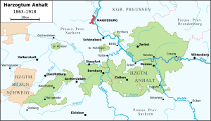
After the lines in Köthen (1847) and Bernburg (1863) were extinguished, the three duchies merged to form a unified duchy of Anhalt with Dessau as the capital . In 1867, Anhalt joined the North German Confederation , which was established under Prussian leadership, as a federal state, and in 1871 it joined the German Empire . It had a voice in the Bundesrat in Berlin, as it did in the Bundestag in Frankfurt am Main.
Free State of Anhalt 1918–1934, since 1934 State of Anhalt
In the course of the November Revolution in 1918, workers 'and soldiers' councils were also formed in Anhalt . They worked more pragmatically and made no radical demands. On November 12th, Prince Regent Aribert, on behalf of the underage Duke Joachim Ernst, announced the abdication and the renunciation of the throne for the ruling family of the Ascanians. Anhalt became a free state in the Weimar Republic . In the state elections in April 1932, the NSDAP was the strongest parliamentary group with 15 seats (6 were from Dessau).
Anhalt after 1945
After the Second World War , the former Prussian province of Saxony merged to form the state of Saxony-Anhalt in the Soviet zone of occupation . However, this state only existed for a short time: During the administrative reform of 1952 , the state of Saxony-Anhalt was divided, and the former part of Anhalt then belonged to the districts of Halle and Magdeburg in the GDR .
With reunification in 1990, the state of Saxony-Anhalt was rebuilt within slightly different boundaries, including all of the Anhalt areas. In the period between the district reforms of 1994 and 2007 there was a district of Anhalt-Zerbst , which since July 1, 2007 has merged into the newly formed district of Anhalt-Bitterfeld ; the historical name “Anhalt” lives on in the state and district name. The area of the Evangelical Church of Anhalt still corresponds to the former Duchy or Free State.
"Anhalt" is also in the name of the Anhalter Bahnhof in Berlin , which was the northern end of the Berlin-Anhalt railway line ( Berlin – Halle line ) and is now just an S-Bahn station .
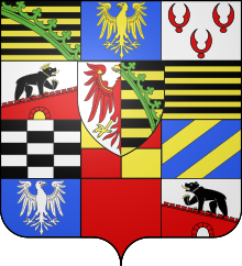
coat of arms
Blazon : The coat of arms is divided three times and split twice with a central shield in the fifth field. In the fields:
- Heart shield (field 5): Split, on the right in silver a red eagle bursting out at the crack, on the left divided nine times by black and gold, covered with a slanted green diamond wreath . (Ancestral coat of arms of the Askanians and small national coat of arms of the Duchy of Anhalt with the Brandenburg eagle and the Saxon diamond coat of arms)
- Field 1: Divided nine times by black and gold. ( Duchy of Saxony , claim coat of arms)
- Field 2: A crowned golden eagle in blue. ( Palatine County of Saxony , claim coat of arms)
- Field 3: In silver three red sea leaves (2: 1). ( Duchy of Engern , claim coat of arms )
- Field 4: In silver, a slant-left red battlement wall with a closed golden gate, on which a black bear with a golden crown and a silver collar is walking to the left. (Family of the Beringer and Duchy of Bernburg)
- Field 6: Divided nine times by black and gold. (Lordship of Ballenstedt in the district of the same name)
- Field 7: Split twice and split three times by black and silver (County of Aschersleben or Askanien )
- Field 8: Divided and split by gold and red. ( Waldersee (noble family) ) reinterpreted as County Waldersee)
- Field 9: In blue two golden oblique left bars. (Alleged county Warmsdorf in the district of Bernburg , the "Goschaft" (lower court) Warmsdorf .
- Field 10: In blue a silver eagle turned left. ( County of Mühlingen )
- Field 11 red. Regalienfeld
- Field 12: In silver, a sloping red battlement wall with an open gate, on it a striding, black bear with a silver collar. (Lordship of Bernburg )
Normative definition of the coat of arms in the ducal coat of arms from 1887.
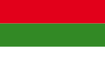
The national colors were red-green-white, sometimes only green-white.
politics
Heads of state
The heads of state were the Dukes of Anhalt until the revolution in 1918 ( see also: Askanier ):
- 1863 to 1871: Leopold IV. (* 1794, † 1871)
- 1871 to 1904: Friedrich I (* 1831, † 1904)
- 1904 to April 21, 1918: Friedrich II. (* 1856, † 1918)
- April 22 to September 13, 1918: Eduard (* 1861, † 1918)
- September 14 to November 12, 1918: Joachim Ernst (* 1901, † 1947) under the tutelage of the regent Aribert
Minister of State
The chairmen of the Ducal-Anhalt State Ministry or State Minister were:
- 1863 to 1868: Carl Friedrich Ferdinand Sintenis (1804–1868)
- 1868 to 1875: Alfred von Larisch (1819–1897)
- 1875 to 1892: Anton von Krosigk (1820–1892)
- 1892 to 1903: Kurt von Koseritz (1838–1916)
- 1903 to 1909: Johann (Hans) Nikolaus Michael Louis von Dallwitz (1855–1919)
- 1910 to 1918: Ernst von Laue
- 1918: Max Gutknecht (1876–1935)
Administrative division of Anhalt until 1932
Data
- National colors : red - green - white
- Population: 193,046 (1864), 431,422 (1939)
- Cities: Ballenstedt , Gernrode , Gröbzig , Harzgerode , Hoym
Bernburg (Saale) , Güntersberge , Güsten , Hecklingen , Leopoldshall , Nienburg , Sandersleben
Dessau , Radegast , Jeßnitz (Anhalt) , Raguhn , Roßlau , Köthen , Zerbst , Coswig - Exclaves: Großalsleben , Gödnitz , Groß- and Klein-Mühlingen, Dornburg , Tilkerode
- Prussian enclaves: Löbnitz ad Linde, Repau, Pösigk, Priorau
In 1942 the Prussian communities of Löbnitz ad Linde, Repau, Pösigk, Schierau , Priorau, Möst and Goltewitz were incorporated into the state of Anhalt and the communities of Tilkerode , Unterwiederstedt and Wadendorf were spun off into the province of Saxony in the state of Prussia.
Population and area
Development of the population
75,523 residents; 2299 km² (1871)
100,702 inhabitants; 2299 km² (1910)
351,045 inhabitants; 2299 km² (1925)
436,213 inhabitants; 2314 km² (May 1939)
Biggest Cities 1939
- Dessau (with Roßlau ): 117,110 inhabitants
- Bernburg : 40,732 inhabitants
- Koethen : 32,037 inhabitants
- Zerbst : 22,149 inhabitants
- Coswig : 12,645 inhabitants
- Jeßnitz : 11,817 inhabitants
- Leopoldshall : 7,485 inhabitants
- Ballenstedt : 6,729 inhabitants
- Raguhn : 6,038 inhabitants
- Güsten : 5,997 inhabitants
- Nienburg : 5,961 inhabitants
- Hecklingen : 5,183 inhabitants
- Kochstedt : 5,173 inhabitants
literature
- Johann Christoph Beckmann : History of the Principality of Anhalt. 2 vols. Zimmermann, Zerbst 1710; Erg.-Bd. Accessiones. Zerbst 1716 (reprint: Dessau 1995, DNB 947263349 )
- Walther Eggert: Anhalt Mosaic: Landscape and cultural images from the former state of Anhalt. Weidlich, Frankfurt am Main 1971, ISBN 3-8035-0555-0 .
- Bernd Feicke (Ed.): 800 Years Anhalt 1212-2012 (= Harz-Zs. 64, Berlin and Wernigerode 2012), ISBN 978-3-86732-137-2 .
- Werner Freitag, Michael Hecht (ed.): The princes of Anhalt. Symbolism of rule, dynastic reason and political concepts in the late Middle Ages and early modern times. Halle (Saale) 2009, ISBN 978-3-89812-199-6 .
- Otto von Heinemann : Codex diplomaticus Anhaltinus 6 parts. 1867–1883.
- Johannes Jansson: The Principality of Anhalt and the Archdiocese of Magdeburg - 1647. (Historical map: Principatus Anhaldinus et Magdeburgensis Archiepiscopatu). (Reprint: Rockstuhl, Bad Langensalza 2003, ISBN 3-932554-92-2 )
- Wilhelm van Kempen: Palaces and manors in the province of Saxony and in Anhalt . Weidlich, Frankfurt am Main 1961.
- Gottlieb Krause (Ed.): Documents, files and letters on the history of the Anhalt region. 7 parts in 5 volumes, Leipzig 1861–1866.
- Heinrich Lindner: History and description of the state of Anhalt. Dessau 1833.
- Hermann Lorenz: The history of Anhalt in words and pictures. Publishing house by Otto Schulze, Cöthen 1900.
- Colonel a. D. Ferdinand von Losch: Memorandum of the Herzoglich Anhaltischen Jägerbrigade 1810-1910 , Dessau (Dünnhaupt) 1910.
- Norbert Michels (Ed.): Anhalt in old views: landscape, architecture, living worlds. Mitteldeutscher Verlag, Halle 2006, ISBN 3-89812-350-2 .
- Ralf Regener (Ed.): 800 years of Anhalt. Exhibition font. Exhibition from January 16 to December 17, 2012 in the Magdeburg University Library Magdeburg 2016.
- Ralf Regener: The year of the three-dukes in Anhalt, 1918 , in: Saxony-Anhalt. Journal für Natur- und Heimatfreunde 25 (2015), H. 1, S. 19-21.
- Ralf Regener: The fall of the Ascanians in Anhalt in 1918. Conditions, course and aftermath of the fall of a small German monarchy , 2nd edition Dessau-Roßlau 2014; doi : 10.25673 / 13730
- Friedrich Winfried Schubart : The bells in the Duchy of Anhalt - a contribution to the history and antiquity of Anhalt and to general bells . With three hundred illustrations drawn by W. Peters, Dessau: Baumann, 1896
- Reinhold Specht: Bibliography on the history of Anhalt. 1930/1935
- Studium Hallense eV (Hrsg.): History of Anhalt in data . Mitteldeutscher Verlag, Halle (Saale) 2014, ISBN 978-3-95462-229-0 .
- Justus H. Ulbricht (Ed.): Anhalt's way into the "Age of Extreme" 1871-1945. Mitteldeutscher Verlag, Halle (Saale) 2013, ISBN 978-3-95462-111-8
- Hermann Laundry : Anhalt history. 3 volumes, Cöthen 1912/1913
- Manfred Wilde : Witch trials in the Anhalt principalities. In: On the way to a story of Anhalt. Announcements from the Verein für Anhaltische Landeskunde. 21st year 2012, special volume (conference proceedings). Köthen 2012, pp. 133–157.
- J. Wütschke: Territorial development of Anhalt. (Atlas of the Saale and central Elbe region) 1958.
Web links
- The history of Anhalt ( Memento from February 9, 2010 in the Internet Archive )
- The castle ruins of Anhalt
- Duchy of Anhalt
- Duchy of Anhalt (districts and municipalities) 1910
- History of the country
- Anhalt map at the end of the 18th century
Individual evidence
- ↑ Ralf Regener: The fall of the Askanians in 1918 in Anhalt. In: Justus H. Ulbricht (Ed.): Anhalt's way into the “Age of Extremes” 1871–1945. Halle (Saale) 2014, pp. 29–49.

