
Schoenburg dominions
Schönburg rulers denote the property of the House of Schönburg in the west of today's Free State of Saxony . On the one hand, it refers to the five imperial-free dominions of Waldenburg , Glauchau , Lichtenstein , Hartenstein and Stein , which gradually became part of the Saxon state after the recession with the Saxon elector in 1740 as the Schönburg recession . On the other hand, the term denotes the electoral offices of Remse , Penig , Rochsburg and Wechselburg , which were lent to the Schönburgers ( Schönburg feudal lords ).
Geographical expansion
Until the sale of the upper county of Hartenstein in 1559, the area of the Schönburg rule consisted of three, then two separate areas. The five recess rulers and the state rulership of Remse formed the core of the Schönburg possessions. It reached from the Erzgebirge near Hartenstein to the Erzgebirge foothills. The Zwickauer Mulde flowed through the area near Hartenstein and from Glauchau to Wechselburg . The corridors of Wolkenburg-Kaufungen separated the territory of the Rezessherrschaft from the territories of Penig, Rochsburg and Wechselburg. Tributaries of the Zwickauer Mulde in the Schönburg area were the Lößnitzbach , the Mülsenbach in the Mülsengrund , the Lungwitzbach , the Chursbachtal and the lower valley of the Chemnitz from Taura to the confluence with the Zwickauer Mulde.
The upper county of Hartenstein was separated from the lower county by the Saxon office of Grünhain . It was located in the ridge area of the Fichtelberg and included the Crottendorfer Forest and the upper reaches of the rivers Große Mittweida , Zschopau , Sehma and Pöhlbach . Another important mountain in the area is the Scheibenberg (Ore Mountains) . The southern border of the office also formed the national border to Bohemia .
The territory of the Rezessherrschaft is today in the north and east of the district of Zwickau . The area of the lower county of Hartenstein is mainly in the east of this district, the sovereign rulers are now in the west of the central Saxony district .
Adjacent administrative units
The information relates to the Schönburg rulers with the five recess rulers, the four regional rulers and the residence city of Glauchau. The boundaries of the upper county of Hartenstein and the exclave of the Borna district , which divided the rulers, are neglected here.
.svg)
history
Creation of the Schoenburg dominions, which were immediately part of the empire
The noble family of Schönburgs was first mentioned in 1130 on the Schönburg near Naumburg . Originally it owned an imperial area from 1182 in the area of Geringswalde near Mittweida , which was ceded to the Electorate of Saxony ( Rochlitz Office ) in 1590 . The Schönburg house came into possession of the Glauchau area around 1170 . From there they formed the imperial dominions Glauchau (since 1256), Lichtenstein (since 1286) and Waldenburg (since 1378). By lending these areas to the Bohemian king, which lasted until 1779, state sovereignty was guaranteed against the Electorate of Saxony . In 1493, the Meerane dominion , which had been lent to the Schönburgers by the Bohemian king in the 13th century, was combined with the Glauchau dominion. Around 1300 the town of Crimmitschau passed into the possession of the Schönburger, but in 1413 it came to the Wettins .
In 1406, the county of Hartenstein , which was also part of the imperial empire, was pledged by the Meissnian burgrave Heinrich I von Hartenstein to the Schönburg family. Burgrave Heinrich I von Hartenstein, however, exempted the Wildenfels lordship, which had previously belonged to Hartenstein, from this pledge and remained its liege lord, whereby this area was finally separated from Hartenstein after 1440. With the Preßburger power ruling in 1439, the Saxon Wettins were indirectly feudal lords of the county of Hartenstein, which in 1456/57 by Emperor Friedrich III. was confirmed again. Since the partition of Leipzig in 1485, the Schoenburg dominions lay between the territories of the Albertine Duchy of Saxony in the east and the Ernestine Electorate of Saxony in the west and north. Since then, until the defeat of the Ernestines in the Schmalkaldic War in 1547, they separated the Electoral Saxon Ernestine area in the west with the city of Zwickau from the ducal Saxon Albertine Saxony in the east with the city of Chemnitz . Since the county of Hartenstein, in contrast to the other lordships, was an Electoral Saxon Reichsafter fief , the Reformation was introduced in the county as early as 1539/40 and thus three years earlier than in the then Bohemian Reich afterfiefs of Lichtenstein, Glauchau and Waldenburg. At the Reichstag , the Schoenburgers were partly represented by the Wetterau Count Association .
Territorial changes
In 1488 the Tirschheim manor with two villages and two village parts came from the Remse monastery to the Lords of Schönberg. Since the four scattered places were fiefs from the Electorate of Saxony, the administration took over its own thing chair , which had the competence of a Saxon vassal court . The jurisdiction, however, lay with the Lords of Schönburg.
In the year 1524 the "general house" Schönburg with the seat of government Glauchau was set up in order to prevent the disintegration of the Schönburg rule in the event of future partitions and to have a uniform representation to the outside world.
In exchange for the Schönburg offices of Hohnstein , Lohmen , Wehlen in Saxon Switzerland and the rule of Kriebstein near Mittweida , the Schönburgers received the Albertine offices of Remse , Penig , Wechselburg (all 1543) and Rochsburg (1548) as fiefdoms. In 1559 the upper part of the county of Hartenstein was sold by the Schönburgers to the Wettins and was re-established as the Electoral Saxon office of Crottendorf . In 1681 the rule of Glauchau was divided into the partial dominions of Fordglauchau and Hinterglauchau . From 1683 to 1763 was Forderglauchau in turn divided into a Penigschen and a Wechselburger share. With the death of Otto Ludwig von Schönburg in 1701 and the inheritance contract of his four sons entitled to inheritance, the Stein rule was formed in 1702 from part of the Hartenstein county.
Loss of imperial immediacy and gradual integration into the Saxon state

In 1740, the Wettins concluded a recess with the Lords of Schönburg, through which the Schönburgers had to recognize the sovereignty of the Saxon ruling house over the domains of Waldenburg, Glauchau, Lichtenstein, Hartenstein (the lower county) and Stein, which had previously been imperial. The feudal rule of the Bohemian king over the now "Rezessherrschaft" areas of Waldenburg, Glauchau and Lichtenstein ended in 1779. With the transition of these dominions to Saxon fiefdoms, the gradual integration into the Saxon state took place.
Since 1835 the feudal lordship of Remse with the lordship of Tirschheim and Ziegelheim was administratively administered by the royal Saxon office of Zwickau . The other three feudal lords, Penig , Wechselburg and Rochsburg , which were territorially separated from the recess rulers by a small exclave of the Borna district ( Cloud Castle ), fell under the administration of the Rochlitz royal Saxon district in 1835 .
The five Rezessherrschaft remained under Schönburg sovereignty until 1878. After that they were fully integrated into the Kingdom of Saxony . The Glauchau administration was formed in 1880 from the dominions of Waldenburg, Glauchau and Lichtenstein and the Remse office . The lordship of Stein and the lower county of Hartenstein (excluding the judicial district of Lößnitz ) came to the Zwickau administration . The Hartstein judicial district of Lößnitz was assigned to the Schwarzenberg administration . Thereafter, the Schönburg House only had private property in independent management until it was expropriated in 1945 by the land reform carried out in the Soviet occupation zone .
Schoenburg rulers
The Schoenburg dominions belonged to the following lines:
-
the princely line Schönburg-Waldenburg:
- the rule of Waldenburg (until 1779 the Bohemian Reichsafterlehen, then the Saxon Reichsafterlehen)
- the rule of Lichtenstein (until 1779 the Bohemian Reichsafterlehen, then the Saxon Reichsafterlehen)
- the rule of Hartenstein (from 1559 only the lower county) (since 1439 Saxon Reichsafterlehen)
- the rule of Stein (since the separation from Hartenstein in 1701 own Saxon Reichsafterlehen)
- the dominion of Remse (Remissa) (since 1543 Electoral Saxon fiefdom)
-
the count's line to Rochsburg and Hinterglauchau:
- the rulership of Rochsburg (fiefdom of the Electorate of Saxony since 1548)
- the rulership of Hinterglauchau (until 1779 a Bohemian fiefdom, then a Saxon imperial fiefdom)
-
the count's line to Penig-Penig:
- the rule of Penig (since 1543 an Electoral Saxon fiefdom)
- the rulership of Wechselburg (fiefdom of the Electorate of Saxony since 1543)
- the rule of Fordglauchau (until 1779 Bohemian Reichsafterlehen, then Saxon Reichsafterlehen)
After the recess of May 4, 1740, in which the Schönburgers recognized the sovereignty of the Saxon ruling house of the Wettins over their territories, the five imperial dominions were Waldenburg, Glauchau (front and rear portion), Lichtenstein, Hartenstein (lower county) and Stein referred to as the recess rule. The four Electoral Saxon feudal offices Remse (Remissa), Penig, Rochsburg and Wechselburg were designated as territorial lords .
History of the written offices before the transfer to the House of Schönburg
The offices of Penig and Rochsburg were given to the Burgraves of Altenburg by the Wettins in the 13th century . After the male line of the Altenburg Burgraves died out, the two offices were conferred on the Burgraves of Leisnig , who were related to them, in the 15th century . In 1543 and 1548 they were exchanged for the Schönburg family. Electoral Saxony retained supremacy over both areas. They belonged to the Albertine line of the Wettins since the division of Leipzig in 1485 . The offices of Wechselburg and Remse have their origins in clergy. The office of Wechselburg was owned by the Canons' Monastery, consecrated in 1168, and handed over to the Teutonic Order in 1278 . After the introduction of the Reformation , the office was secularized in 1541 and handed over to the Schönburgers as an electoral fief. The Remse office was owned by the Remse Monastery under Schönburg sovereignty. In 1533 it fell to the Ernestine Elector and in 1543 it became the office of Schönburg under Electoral Saxon sovereignty.
Dominions and associated places
Schönburg recess rulers (immediately imperial until 1740)
Remarks:
- After the sale to the Saxon elector, the electoral office of Crottendorf was formed from the upper county of Hartenstein .
- Since 1681 the Glauchau rulership consisted of the two sublords of front and Hinterglauchau, whose possessions are mentioned here together.
| place | current location | associated recess rule | Period of the Schönburg ownership | Remarks |
|---|---|---|---|---|
| Alt Wiesenthal ( Unterwiesenthal ) | City of Oberwiesenthal health resort | upper county of Hartenstein | 1406-1559 | after 1559 to the office of Crottendorf |
| Neustadt Wiesenthal (City of Oberwiesenthal ) | City of Oberwiesenthal health resort | upper county of Hartenstein | 1406-1559 | Founded in 1530; after 1559 Amt Crottendorf |
| Kretscham-Rothensehma | community Sehmatal | upper county of Hartenstein | 1406-1559 | after 1559 to the office of Crottendorf |
| Neudorf | community Sehmatal | upper county of Hartenstein | 1406-1559 | after 1559 to the office of Crottendorf |
| Crottendorf | municipality Crottendorf | upper county of Hartenstein | 1406-1559 | after 1559 to the office of Crottendorf |
| Mountain town of Scheibenberg | City of Scheibenberg | upper county of Hartenstein | 1406-1559 | Founded in 1522; after 1559 to the office of Crottendorf |
| Top pane | City of Scheibenberg | upper county of Hartenstein | 1406-1559 | after 1559 to the office of Crottendorf |
| Mittweida | Community Raschau marker Bach | upper county of Hartenstein | 1406-1559 | after 1559 to the office of Crottendorf |
| Obermittweida | Community Raschau marker Bach | upper county of Hartenstein | 1406-1559 | after 1559 to the office of Crottendorf |
| City of Elterlein with Brünlas and Burgstädtel | City of Elterlein | upper county of Hartenstein | 1406-1559 | after 1559 to the office of Crottendorf |
| Großpöhla | City of Schwarzenberg / Erzgeb. | upper county of Hartenstein | 1406-1559 | after 1559 to the office of Crottendorf |
| Bergstadt Lößnitz with Dreihansen | City of Loessnitz | lower county of Hartenstein | 1406-1878 | Capital of the county of Hartenstein |
| Niederlößnitz , Grüna , Ober- and Niederaffalter , Streitwald | City of Loessnitz | lower county of Hartenstein | 1406-1878 | Grüna mentioned for the first time in 1528, Streitwald only emerged in the 17th century. |
| Alberoda | City of Aue | lower county of Hartenstein | 1406-1878 | with the Edelhof |
| Low pan handle | City of Aue | lower county of Hartenstein | 1406-1878 | was not created until the 17th century |
| Oberpfannenstiel | City of Lauter-Bernsbach | lower county of Hartenstein | 1406-1878 | was not created until the 17th century |
| Lenkersdorf (Hartstein part) | City of Zwönitz | lower county of Hartenstein | 1406-1878 | |
| Deserted villages Kempfersgrün , Sebottendorf and High Brno | lower county of Hartenstein | 1406-1878 | Abandoned settlements Kempfersgrün (between Gablenz, Beutha and Gruena) Sebottendorf (between Loessnitz, space and Gruena) and High Brno (between Loessnitz and Gruenhain) | |
| Bagha | City of Stollberg / Erzgeb. | lower county of Hartenstein | 1406-1878 | |
| room | City of Stollberg / Erzgeb. | lower county of Hartenstein | 1406-1878 | was not created until the 17th century. In his vicinity was the master workshop, which was the executioner's office for the county of Hartenstein. |
| Hartenstein Castle and Hartenstein City | City of Hartenstein | lower county of Hartenstein | 1406-1878 | the city was first mentioned in 1378 |
| Thierfeld , Zschocken (Hartenstein part) | City of Hartenstein | lower county of Hartenstein | 1406-1878 | |
| Stein Castle and Stein | City of Hartenstein | lower county of Hartenstein , from 1701 rule of Stein | 1406-1878 | since 1701 residence of the office of Stein |
| Torrent | Bad Schlema municipality | lower county of Hartenstein , from 1701 rule of Stein | 1406-1878 | with the Isenburg destroyed in 1320 |
| Langenbach | Langenweißbach municipality | lower county of Hartenstein , from 1701 rule of Stein | 1406-1878 | the district of Fährbrücke was not built until the 19th century. |
| Deserts Nieder- and Ober- Opritz between Stein and Langenbach | City of Hartenstein | lower county of Hartenstein , from 1701 rule of Stein | 1406-1878 | |
| Schönau (Hartenstein part) | City of Wildenfels | lower county of Hartenstein | 1406-1878 | after the separation from the dominion of Wildenfels, the Hartenstein exclave (from 1440) |
| Oberhaßlau , Niederhaßlau , Rosenthal | City of Wilkau-Haßlau | lower county of Hartenstein | 1406-1878 | after the separation from the dominion of Wildenfels, the Hartenstein exclave (from 1440); as "Haßlau" belongs to Vielau (Hartensteiner part) |
| Vielau (Hartenstein part) with a knight's seat | Community Reinsdorf | lower county of Hartenstein | 1406-1878 | after the separation from the dominion of Wildenfels, the Hartenstein exclave (from 1440) |
| Reinsdorf (Hartensteiner part) with the manor | Community Reinsdorf | lower county of Hartenstein | 1406-1878 | small amount |
| Härtensdorf (Hartenstein part) | City of Wildenfels | lower county of Hartenstein | 1406-1878 | smaller proportion |
| Oelsnitz / Erzgeb. (Hartenstein share) | City of Oelsnitz / Erzgeb. | lower county of Hartenstein | 1406-1878 | |
| Ortmannsdorf (Hartensteiner part) with the manor and Neudörfel (from 1923: Neuschönburg) | Mülsen municipality | lower county of Hartenstein | 1406-1878 | |
| Ortmannsdorf (Lichtensteiner part) with the manor and Neudörfel (from 1923: Neuschönburg) | Mülsen municipality | Lordship of Lichtenstein | 1286-1888 | |
| Mülsen St. Niclas, Mülsen St. Jacob | Mülsen municipality | lower county of Hartenstein | 1406-1878 | |
| Mülsen St. Micheln, Stangendorf, Thurm | Mülsen municipality | Lordship of Lichtenstein | 1286-1888 | |
| Niedermülsen, Berthelsdorf and Wulm | Mülsen municipality | Lordship of Glauchau | 1256-1878 | |
| City of Lichtenstein with the Lichtenstein Castle | City of Lichtenstein | Lordship of Lichtenstein | 1286-1888 | Residence of the Lichtenstein rule |
| Rödlitz , Callnberg (founded in 1708) | City of Lichtenstein | Lordship of Lichtenstein | 1286-1888 | |
| Hohndorf | Municipality of Hohndorf near Stollberg / Erzgeb. | Lordship of Lichtenstein | 1286-1888 | |
| Gersdorf | Community of Gersdorf | Lordship of Lichtenstein | 1286-1888 | |
| Bernsdorf , Rüsdorf | Commune Bernsdorf | Lordship of Lichtenstein | 1286-1888 | |
| Oberlungwitz | City of Oberlungwitz | Lordship of Lichtenstein | 1286-1888 | City since 1936 |
| Cow snappers | St. Egidien parish | Lordship of Lichtenstein | 1286-1888 | |
| St. Egidien , Lobsdorf | St. Egidien parish | Lordship of Glauchau | 1256-1878 | |
| City of Glauchau with the two castles, Castle Fordglauchau and Castle Hinterglauchau | City of Glauchau | Lordship of Glauchau | 1256-1878 | Residence of the lords of Ford and Hinterglauchau |
| Albertsthal, Gesau, Höckendorf, Hölzel, Jerisau, Kleinbernsdorf, Lipprandis, Niederlungwitz , Reinholdshain , Rothenbach, Schönbörnchen, Voigtlaide, Wernsdorf | City of Glauchau | Lordship of Glauchau | 1256-1878 | |
| Oberrothenbach (without Helmsdorf), Schlunzig, Jüdenhain, Mosel (Schönburg part) | City of Zwickau | Lordship of Glauchau | 1256-1878 | |
| Dennheritz (Schönburg part), Niederschindmaas (Schönburg part), Oberschindmaas | community Dennheritz | Lordship of Glauchau | 1256-1878 | |
| City of Meerane | City of Meerane | Lordship of Glauchau | 1256-1878 | |
| Seiferitz (Schönburg part), Waldsachsen (Saxon part) | City of Meerane | Lordship of Glauchau | 1256-1878 | |
| Kauritz (Saxon share) (exclave) | City of Gößnitz (Thuringia) | Lordship of Glauchau | 1256-1878 | |
| Schönberg (Glauchau share), Pfaffroda (Glauchau share) | Community of Schönberg | Lordship of Glauchau | 1256-1878 | |
| Schönberg (Waldenburg share), Pfaffroda (Waldenburg share) | Community of Schönberg | Reign of Waldenburg | 1378-1878 | |
| Bergstadt Hohenstein (founded in 1490) (Glauchau part), city of Ernstthal (founded 1680) (Glauchau part) | City of Hohenstein-Ernstthal | Lordship of Glauchau | 1256-1878 | |
| Bergstadt Hohenstein (founded 1490) (Waldenburg part), town Ernstthal (founded 1680) (Waldenburg part) | City of Hohenstein-Ernstthal | Reign of Waldenburg | 1378-1878 | |
| City of Waldenburg with the Waldenburg Castle | Waldenburg | Reign of Waldenburg | 1378-1878 | Residence of the Waldenburg rule |
| Dürrenuhlsdorf, Franconia, Niederwinkel, Swabia (Waldenburg share) | City of Waldenburg | Reign of Waldenburg | 1378-1878 | |
| Hermsdorf | Commune Bernsdorf | Reign of Waldenburg | 1378-1878 | |
| Callenberg , Grumbach , Reichenbach (Waldenburger share), Obercallenberg , Falken , Langenberg , Langenchursdorf and Meinsdorf | Municipality Callenberg | Reign of Waldenburg | 1378-1878 | |
| Oberwiera (Waldenburg share), Wickersdorf (Saxon share) | Municipality of Oberwiera | Reign of Waldenburg | 1378-1878 | |
| Ziegelheim , Thiergarten, Uhlmannsdorf , Gähsnitz , Niederarnsdorf , Heiersdorf (Saxon share) | Municipality of Ziegelheim (Thuringia) | Reign of Waldenburg | 1378-1878 | |
| Frohnsdorf (Saxon share) | Community Frohnsdorf (Thuringia) | Reign of Waldenburg | 1378-1878 |
Schönburg regional lordships (Electoral Saxon offices under the suzerainty of the House of Schönburg)
| place | current location | associated sovereignty | Period of the Schönburg ownership | Remarks |
|---|---|---|---|---|
| Remse with the Benedictine nunnery Rother Stock | Remse municipality | Office Remse | 1543-1835 | Main town of the Remse district |
| Oertelshain, Kertzsch, Kleinchursdorf , Weidensdorf | Remse municipality | Office Remse | 1543-1835 | |
| Upper angle | City of Waldenburg | Office Remse | 1543-1835 | |
| Oberwiera (Remser part), Harthau (Saxon part), Neukirchen (Saxon part) | Municipality of Oberwiera | Office Remse | 1543-1835 | |
| Breitenbach, Tettau, Oberdorf, Wünschendorf | Community of Schönberg | Office Remse | 1543-1835 | |
| Ebersbach | City of Glauchau | Office Remse | 1543-1835 | |
| Oberlungwitz Abbey (exclave) | City of Oberlungwitz | Office Remse | 1764-1835 | before 1764 to the office of Grünhain |
| Tirschheim (exclave) | St. Egidien parish | Office Penig | 1543-1835 | |
| Swabia (Peniger share) (exclave) | City of Waldenburg | Office Penig | 1543-1835 | |
| Bräunsdorf (part of Schönburg), KÄNDER (part of manor) | City of Limbach-Oberfrohna | Office Penig | 1543-1835 | |
| Reichenbach (Peniger share) (exclave) | Municipality Callenberg | Office Penig | 1543-1835 | |
| City of Penig | City of Penig | Office Penig | 1543-1835 | Main town of the Penig office |
| Altpenig, Chursdorf (Peniger share), Markersdorf , Tauscha, Zinnberg with the castle Zinnberg , Obersteinbach (Saxon share), Niedersteinbach (official share of the Saxon share) and Wernsdorf (Peniger share) | City of Penig | Office Penig | 1543-1835 | |
| Hartmannsdorf , Kühnhaide | Community Hartmannsdorf | Office Penig | 1543-1835 | |
| Murschnitz | City of Chemnitz , Wittgensdorf district | Office Penig | 1543-1835 | 1843 to the office of Chemnitz |
| Mühlau (Peniger share) | commune Mühlau | Office Penig | 1543-1835 | |
| Mühlau (Rochsburg share) | commune Mühlau | Rochsburg Office | 1548-1835 | |
| Taura , Reitzenhain | Taura municipality | Office Penig | 1543-1835 | |
| Göppersdorf with Herrenhaide | City of Burgstädt | Office Penig | 1543-1835 | |
| City of Burgstädt | City of Burgstädt | Rochsburg Office | 1548-1835 | |
| Burkersdorf with Heiersdorf, Helsdorf, Mohsdorf with Schweizerthal | City of Burgstädt | Rochsburg Office | 1548-1835 | |
| Arnsdorf , Dittmannsdorf , Thierbach (exclave in the Penig district ), Chursdorf (Rochsburg share) and Wernsdorf (Rochsburg share) | City of Penig | Rochsburg Office | 1548-1835 | |
| City of Lunzenau | City of Lunzenau | Rochsburg Office | 1548-1835 | |
| Rochsburg with Rochsburg Castle | City of Lunzenau | Rochsburg Office | 1548-1835 | Capital of the Rochsburg district |
| Himmelhartha , Berthelsdorf, Schlaisdorf, Elsdorf | City of Lunzenau | Rochsburg Office | 1548-1835 | |
| Cossen, Göritzhain, Hohenkirchen | City of Lunzenau | Wechselburg Office | 1543-1835 | |
| Wechselburg with the former Augustinian canons of Zschillen | Community Wechselburg | Wechselburg Office | 1543-1835 | Main town of the Wechselburg district |
| Altzschillen, Corba, Göhren, Göppersdorf, Hartha, Seitenhain | Community Wechselburg | Wechselburg Office | 1543-1835 | |
| Claußnitz , Diethensdorf, Markersdorf / Chemnitztal, Röllingshain | community Claußnitz | Wechselburg Office | 1543-1835 | |
| Königshain, Wiederau, Stein im Chemnitztal, Topfseifersdorf | Municipality Königshain-Wiederau | Wechselburg Office | 1543-1835 | |
| Angles | community Seelitz | Wechselburg Office | 1543-1835 | |
| Nauenhain (exclave) | City of Geithain | Wechselburg Office | 1543-1835 |
Buildings worth seeing
The Schönburg family built (or took over) a number of castles and palaces in the Schönburg dominions, but also in other parts of Saxony and in Bohemia. (A list can be found under: Schönburg castles and palaces ). These include the following buildings in the former Schönburg dominions (of which the Stein Castle in Hartenstein and the Old Castle in Penig are again owned by the Schönburg-Hartenstein family):
- Fordglauchau Castle and Hinterglauchau Castle , residences of the Glauchau lords
- Waldenburg Castle , former royal residence
- Hartenstein Castle , residence of the Hartenstein County , now in ruins
- Stein Castle near Hartenstein, residence of the Stein rule
- Lichtenstein Castle , residence of the Lichtenstein rule
- Rochsburg Castle near Lunzenau , seat of the Rochsburg Office
- Augustinian Canons Monastery of Zschillen in Wechselburg , later the seat of the Wechselburg rulership
- Isenburg ruins near Wildbach
- Zinnberg Castle near Penig , the seat of the Penig District, now in ruins
- Edelhof Alberoda
- Former Benedictine nunnery in Rother Stock in Remse , seat of the rulership of Remse
- Grünefelder Park near Waldenburg with several buildings and the Grünefelder Schlösschen (tea house)
- Formerly the Princely Waldenburg "Naturalienkabinett" (collection of curiosities) with a local museum in Waldenburg

preserved outer bailey of Hartenstein Castle

Wechselburg Castle
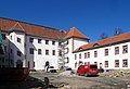
Old Penig Castle

New Penig Castle

former Crimmitschau Castle, today Schweinsburg Castle


.jpg)


.jpg)

Historical maps
From the 18th century at the latest, the Schönburg rulers were drawn on maps by various engravers , publishers and cartographers. This applies in particular to maps by the Leipzig cartographer and copper engraver Johann Georg (e) Schreiber and his descendants or widow.
- 1567: the cartographer Johannes Criginger recorded the Schönburg areas on a map published in Prague in 1568.
- Late 17th / early 18th century: Map "Dynastiae Comitat Schoenburgici Penig, Remissa, Rochsburg, Wechselburg, in Clientela Elect: Saxon Glaucha, Hartenstein, Lichtenstein, Waldenburg ..." by Matthaeo Seutero and geographer Caesar Aug. Vindel
- before 1750: Map by JG Schreiber: The offices of Borna, Pegau and Coldi (t) z located in the Leipzig Creiße…. undated, 18th century, Schoenburg dominions marked therein.
- After 1750: JG Schreiber's widow made the map Die Graeflich Schoenburgischen Herrschafften and Aemter Glauchau, Waldenburg, Lichtenstein, Hartenstein, Stein, Remisssen, Rochsburg, Penig, Wechßelburg, Oelsnitz and Ziegelheim by JGSchreybers seel. Wittbe published after 1750.
- 1760: in Amsterdam the map Accurate Geographische Delineation der Reichs-Gräfl. Schönburgischen Herrschaft und Aemter ... published by Peter Schenk (apparently Peter Schenk the Younger ). (Lords of Glauchau, Waldenburg, Lichtenstein, Hartenstein, Stein, Wechselburg, Penig, Rochsburg, Remissa)
- 1760: Map by Johann Paul Trenckmann, the son of Paul Trenckmann : "Comitatvs Schonburgensis .... Hartenstein et Dynastia Stein ... Remissau, Rochsburg, Penig, Wechselburg, Oelsnitz, Ziegelheim ..."
Web links
- Office directory - the Schönburg offices in the historical register of Saxony.
- The Schönburg rulers in the Saxon State Archives in Chemnitz
- Glauchau rule in history - ANA
- History of Stein Castle
literature
- Karlheinz Blaschke , Uwe Ulrich Jäschke : Kursächsischer Ämteratlas 1790 , Chemnitz 2009, ISBN 978-3-937386-14-0 .
- Leo Bönhoff : The original extent of the county of Hartenstein. In: New Archive for Saxon History, 27 (1906), pp. 209–278.
- Walter Schlesinger : The sovereignty of the Lords of Schönburg. A study on the history of the state in Germany (sources and studies on the constitutional history of the German Empire in the Middle Ages and Modern Times, 9.1), Münster and Cologne 1954.
- Lothar Wendler: Castles in the Western Ore Mountains - on the Mulde, Schwarzwasser and Zschopau. from the series Unser Heimat , Rockstroh's illustrated sheets on the history of the Western Ore Mountains, printer & publisher Mike Rockstroh, Aue, 2004.
- Wolf-Dieter Röber , Steffen Winkler: Geringswalde Monastery. In: Series of publications, issue 6, Museum and Art Collection Schloss Hinterglauchau, City of Glauchau, 1986, GDR, pp. 35–39 (on the history of the rule and castle Geringswalde, as well as the monastery and state school under the Lords of Schönburg until it was sold to the Wettiner).
- Saxony's Church Gallery, 13th section: The Schönburg Recession Rulers , Dresden, around 1840.
- Portfolio Die Schoenburgschen Schloesser , Wilhelm Gebhardt , around 1867 (contemporary images of the castles).
- Wolf-Dieter Röber : Schönburg castles and palaces in the valley of the Zwickauer Mulde , Sax-Verlag Beucha, 1999, ISBN 978-3-930076-77-2 .
- Fritz Resch: Measure and weight of the former Schönburgische Land up to the 19th century. In: Schönburgische Heimatbücher, No. 9, Glauchau 1936.
- Walter Schlesinger : The Schönburgisches Amt Glauchau in the 16th century (Glauchau, 1937), reprint in: Walter Schlesinger, edited by Thomas Lang: Contributions to the history of the city of Glauchau. Edited by Enno Bünz. Thelem Verlag, Dresden 2010, ISBN 978-3-939888-59-8 .
- Reconstructed map of the lordship (s) Penig (with Rochsburg and Burg Zinnberg) in 1436 when the rulership was transferred from the Altenburg burgraves to the burgraves of Leisnig due to marriage (this double rule corresponds to the older Drachenfels rule and came after the burgraves of Leisnig ultimately to the gentlemen of Schönburg), In: Horst Schwabe: Mein Burgstädt. Riedel-Verlag Röhrsdorf, 1993, without ISBN, p. 9.
- Carl Heinrich Pinther: "Topography of Schönburg, with various Beylagen", Halle / Saale, 1802 (on the Schönburg dominions and their history)
Individual evidence
- ↑ Book “Das Schönburgische Amt Hartenstein 1702–1878”, p. 148.
- ↑ Bernd Borchardt u. a .: Crimmitschau - history of a city . tape 1 . Geiger, Horb am Neckar 2013, ISBN 978-3-86595-504-3 , p. 33 .
- ↑ The places of Patrimonialgerichts Tirschheim under the administration of the rule Penig in the book "Geography for all levels", page 904 and 899 (Schwaben)
- ↑ The patrimonial Tirschheim under the administration of Justice Office Remse in the "Handbook of geography," S. 410th
- ↑ Description of the district of the Zwickau district directorate from p. 192.
- ↑ Incorporation of the Remse rule with the Tirschheim and Ziegelheim dinghies in the Zwickau district directorate, “Handbook of the royal Saxon legislation of January 28 and 30, 1835”, p. 132.
- ^ The Zwickau Office in the Archives of the Free State of Saxony
- ^ The rule of Penig in the archive of the Free State of Saxony
- ^ The rule of Rochsburg in the archive of the Free State of Saxony
- ^ The rule of Wechselburg in the archive of the Free State of Saxony
- ↑ Reiner Groß: Schönburgische Geschichte, Ein Zeittafel. Editors: Britta Günther, Michael Wetzel, Tommy Schmucker, Chemnitz 2005, entry "1567" on p. 17.
- ↑ Reiner Groß: Schönburgische Geschichte, Ein Zeittafel. Editors: Britta Günther, Michael Wetzel, Tommy Schmucker, Chemnitz 2005, reduced map on the back
- ↑ Reiner Groß: Schönburgische Geschichte, Ein Zeittafel. Editors: Britta Günther, Michael Wetzel, Tommy Schmucker, Chemnitz 2005, Peter Schenk's card is mentioned on p. 27.
Electorates: Electorate of Saxony | Electorate of Brandenburg
Spiritual principalities: Diocese of Cammin
Imperial prelatures: Quedlinburg Abbey | Gernrode Abbey | Walkenried Abbey
Secular principalities: Principality of Anhalt | Saxony-Altenburg | Saxe-Coburg | Saxe-Coburg-Eisenach | Saxony-Coburg-Saalfeld | Saxony-Eisenberg | Saxony-Eisenach | Saxe-Gotha | Saxe-Gotha-Altenburg | Saxony-Hildburghausen | Saxony-Jena | Saxony-Saalfeld | Saxe-Weimar | Duchy of Saxony-Weissenfels-Querfurt | Duchy of Western Pomerania | Duchy of Western Pomerania | Principality of Reuss | Principality of Schwarzburg-Rudolstadt | Principality of Schwarzburg-Sondershausen
Imperial counties and imperial lords: Barby | Principality of Hatzfeld | County of Hohnstein | County of Lohra | County of Klettenberg | Mansfeld County | Schoenburg dominions | County of Stolberg | County of Wernigerode