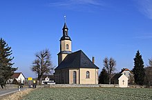
Grumbach (Callenberg)
|
Grumbach
Municipality Callenberg
Coordinates: 50 ° 49 ′ 51 ″ N , 12 ° 37 ′ 53 ″ E
|
||
|---|---|---|
| Area : | 4.37 km² | |
| Residents : | 329 | |
| Population density : | 75 inhabitants / km² | |
| Incorporation : | March 1, 1974 | |
| Postal code : | 09337 | |
| Area code : | 037608 | |
|
Location of Grumbach in Saxony |
||
Grumbach is a district of the municipality of Callenberg in the district of Zwickau (Free State of Saxony ). The place was incorporated into Callenberg on March 1, 1974.
geography
Geographical location and traffic
Grumbach is located in the southwest of the municipality of Callenberg am Kiefernberg. The Callenberger Bach, a tributary of the Zwickauer Mulde, flows through the village . The Oberwald reservoir is located east of Grumbach.
To the south of the village lies the federal highway 4 , to the east of Grumbach the federal highway 180 passes. Both meet at the “Hohenstein-Ernstthal” junction. The Hintergrumbach settlement is located directly south of the A4 on "Lobsdorfer Straße". Between 1960 and 1990, the now disused and dismantled line of the industrial railway of the St. Egidien nickel smelter ran through the southern part of Grumbach . The Grumbach Viaduct has been preserved to this day.
Neighboring places
| Upper angle | Callenberg | |
| Reinholdshain |

|
Reichenbach |
| Lobsdorf | Tirschheim | Obercallenberg |
history
The Waldhufendorf Grumbach was first mentioned in 1390 as "Grumbach" or "Grunbach". The settlement of the place took place as early as the 12th century, probably at the instigation of the Remse monastery , to whose domain the village belonged until 1495. In the run-up to the change of rule over Grumbach, a document from 1488 between the abbot of Remse Monastery and the Lords of Schönburg stipulated that the place would remain in the possession of the monastery, but that the hunting would be taken over by the Lords of Schönburg. In 1495, Grumbach was finally ceded to the Schönburger.
With regard to the basic rule then belonged Grumbach until the 19th century as office Village for nice burg rule Waldenburg . The district Hintergrumbach south of the "Cold Field" and today's A4 was probably not built until the 18th century. At the beginning of the 20th century, a manor developed from the Vorwerk that existed at that time . The Grumbach Church, dating from 1208, was demolished in 1816 and 1817 due to its dilapidation and the present day church was built in its place. Inside is a larger than life crucifix by Peter Breuer . After an administrative reform was carried out in the area of the Schönburg recession in 1878, Grumbach came to the newly founded Saxon governorate of Glauchau in 1880 .
Grumbach was under American occupation between mid-April and June 1945. As a result of the second district reform in the GDR , the municipality of Grumbach came to the Hohenstein-Ernstthal district in the Chemnitz district in 1952 (renamed the Karl-Marx-Stadt district in 1953 ). After the Grumbach School was closed in 1953, all of the town's students attended the Callenberg Central School. Until it was incorporated into Grumbach on March 1, 1974, the Grumbach school building was then used as a community administration. Between 1959/60 and 1990 the industrial railway of the St. Egidien nickel smelter was in operation and crossed the upper part of the village on a road bridge that is still visible today. It connected the St. Egidien nickel smelter with the nickel mine in the Callenberg area. The Callenberg Süd I opencast mine east of Grumbach was opened in 1982 as the Oberwald reservoir after its closure in 1977 . As a district of the municipality of Callenberg, Grumbach came to the Saxon district of Hohenstein-Ernstthal in 1990 , which was added to the district of Chemnitzer Land in 1994 and in 2008 to the district of Zwickau.
Web links
- Grumbach in the Digital Historical Directory of Saxony
- Grumbach on the website of the municipality of Callenberg
Individual evidence
- ↑ Grumbach on the website of the community of Callenberg
- ↑ Handbook of Geography, p. 503
- ↑ Grumbach in the book "Geography for all Stands", p. 899
- ^ Karlheinz Blaschke , Uwe Ulrich Jäschke : Kursächsischer Ämteratlas. Leipzig 2009, ISBN 978-3-937386-14-0 ; P. 92 f.
- ↑ Handbook of Geography, p. 503
- ↑ The Grumbach Manor at www.sachsens-schlösser.de
- ↑ The Glauchau administrative authority in the municipal register 1900
- ↑ Grumbach on gov.genealogy.net


