
Callenberg
| coat of arms | Germany map | |
|---|---|---|

|
Coordinates: 50 ° 51 ' N , 12 ° 38' E |
|
| Basic data | ||
| State : | Saxony | |
| County : | Zwickau | |
| Height : | 310 m above sea level NHN | |
| Area : | 39.86 km 2 | |
| Residents: | 4928 (Dec. 31, 2019) | |
| Population density : | 124 inhabitants per km 2 | |
| Postal code : | 09337 | |
| Primaries : | 03722; 03723 and 037608 | |
| License plate : | Z, GC, HOT, WDA | |
| Community key : | 14 5 24 020 | |
| Community structure: | 7 districts | |
| Address of the municipal administration: |
Rathausstraße 40, district Falken 09337 Callenberg |
|
| Website : | ||
| Mayor : | Daniel Röthig ( CDU ) | |
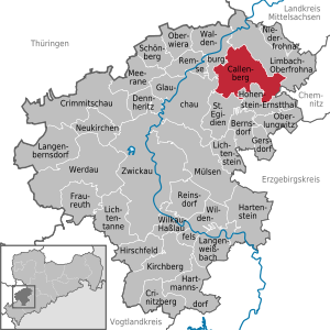
| Location of the community of Callenberg in the district of Zwickau | ||
  |
||

Callenberg is a municipality in the northeast of the Zwickau district . The seat of the administration is in the district Falken .
geography
Geographical location and traffic
Callenberg is on the B 180 (Altenburg-Stollberg) between the two towns of Limbach-Oberfrohna and Glauchau . Both cities are approx. 13 km away. 4 km south running A 4 . This can be reached via the Hohenstein-Ernstthal connection . The industrial railway of the St. Egidien nickel smelter ran through the municipality .
Neighboring communities
Adjacent communities are St. Egidien , the cities of Glauchau , Hohenstein-Ernstthal , Limbach-Oberfrohna and Waldenburg in the district of Zwickau and the independent city of Chemnitz .
Community structure
The community consists of the districts Callenberg, Grumbach , Reichenbach , Obercallenberg , Falken , Langenberg , Langenchursdorf and Meinsdorf . The corridor of the repopulated deserted Spielsdorf lies in the districts of Callenberg and Langenchursdorf.
geology


The largest nickel ore deposit in Central Europe is located near Callenberg. Ores were being mined in the vicinity of Callenberg as early as the end of the 14th century . Nickel iron stone has been mined in the Oberwald itself since the 17th century. However, mining came to a standstill in the 18th century. Another dismantling was planned after the First World War , but did not materialize. When the bismuth was looking for pitchblende here after the Second World War , a large nickel deposit was discovered instead. Since the 1950s, was in the room Callenberg nickel ore in the open pit mined and in the nickel refinery St. Egidien processed. This was built around 1960 north of the St. Egidien train station . It was connected to the mines around Callenberg by a narrow-gauge ore railway . After the ore mining was stopped, the ore railway was stopped after 1990 and the line was completely dismantled. The remaining holes in the opencast mines were rehabilitated after 1990. One of them is today's Oberwald reservoir . In 1977 the very rare mineral crocoite or red lead ore (a lead (II) chromate ) was found in the Callenberg North I nickel mine .
history


.jpg)
.jpg)
.jpg)
All seven districts of today's Callenberg community were founded in the 12th to 13th centuries as part of the expansion of the Waldenburg rule . The eponymous main town of Callenberg was first mentioned in 1244 as Kallenberc . The name means something like place on the bald mountain , which is derived from the hill in the lower village that was not forested until around 1840. As early as 1150, a knight's seat was probably built on the Böhmischer Steig , an old trade route on which salt was transported from the Pleißengau from Altenburg to Bohemia . The noble knights of Callenberg owned the knight's seat until around 1300. After Berthold von Cahlenberg, the last representative of this family, had retired to the clergy, the von Kaufungen family took control of Callenberg. Although they were dependent on the lords of Waldenburg , they exercised the manorial rule and jurisdiction over Callenberg and the following villages : Obercallenberg , Langenchursdorf (one third), Falken (manor share), Langenberg , Oberwinkel (only the Glänzelmühle), Niederlungwitz (some Houses) and Mühlau (patrimonial court portion). The residents of Mühlau belonging to the manor Callenberg were subject to their own patrimonial court , which was subordinate to the manor Callenberg. According to tradition, Kunz von Kauffungen , leader of the Altenburg prince robbery on July 8, 1455, is said to have used a rope ladder for the robbery from Altenburg Castle , which came from the knight seat in Callenberg, which at the time belonged to his cousin Dietrich von Kauffungen. The fountain figure "Kunz von Kaufungen" and two information boards at the original location of the manor in the center of Callenberg reminds of this today. Dietrich von Kauffungen is believed to have been executed in Altenburg later because of his complicity. The knight's seat in Callenberg has been known as a manor since 1551 . After the “Jungker von Kauffungen” died out in 1582, the lords of Schönburg -Waldenburg became the owners of the manor. In 1617 it was lent to Jakob Bellyn, then to the von Dobenck family and until 1714 to the von der Planitz family . After the fire in 1799, the manor was rebuilt further north on Waldenburger Strasse. The old manor house was used as an inn from then until its demolition in 1996. The Fronfeste was used as a school between 1848 and 1887. Today it bears the name of the restaurant "Zur alten Schule".
Regarding the manorial rule , Callenberg belonged to the manor Callenberg until the 19th century, which in turn stood as a vassal court under the administration of the Schönburg rule of Waldenburg . After an administrative reform was carried out in the area of the Schönburg recession in 1878, Callenberg came to the newly founded Saxon governorate of Glauchau in 1880 . As early as the beginning of the 19th century, a strong textile industry developed in the village, especially hosiery. Industrialization of the place began in the second half of the 19th century. Between 1886 and 1909 seven round chair knitting workshops were built. Another big line of business for the Callenbergers was the textile industry. In this branch there are still three small companies based in town today. Between 1856 and 1859 Callenberg received the newly built “St. Katharinenkirche ”and in 1924 a new town hall. In the course of the land reform in the Soviet occupation zone from 1945 , the gentlemen of Schönburg-Waldenburg were expropriated. The grounds of the Callenberg manor were divided into 19 new farmer sites .
As a result of the second district reform in the GDR , the Callenberg community came to the Hohenstein-Ernstthal district in the Chemnitz district in 1952 (renamed the Karl-Marx-Stadt district in 1953 ). The community association Callenberg was formed in 1973 from the communities Callenberg, Grumbach, Reichenbach, Langenchursdorf, Falken and Meinsdorf. Just one year later, on March 1, 1974, the community of Grumbach was incorporated. The schools in the surrounding towns of Grumbach and Reichenbach were dissolved in favor of the central school in Callenberg. In 1952, the open cast nickel mine Callenberg Süd I , which was opened in 1982 as the Oberwald reservoir after its closure in 1977, took place in the corridors of the dissolved Bochmann estate in Obercallenberg . The first drilling has been carried out in the Reichenbach area since 1950. Between 1959/60 and 1990 the industrial railway of the St. Egidien nickel smelter was in operation, the mine station of which was located at the crossing between Reichenbach and Obercallenberg. In the continuation, the industrial line ran through the southern part of Reichenbach and east of Callenberg vobei to the opencast mines Callenberg North I (1973–1988), Ore Body 7 (1984–1988) and Callenberg North II (1978–1990) northeast of Callenberg. On the southeast edge of Reichenbach, the Callenberg Süd II was still in operation between 1980 and 1990 . The rare ore crocoite was found in the Callenberg Nord I opencast mine . After nickel mining was discontinued, a parking lot for the Oberwald reservoir was built on the site of the Obercallenberg mine station in 1990. As a relic of the ore railway, two wagons were left standing near the dam of the Oberwald reservoir. The embankment together with some of the foundations of the overhead line masts, bridge piers and signal remnants are evidence of the industrial railway in the districts of Grumbach, Obercallenberg, Reichenbach, Callenberg and Spielsdorf to this day. The remaining open pit holes were rehabilitated after 1990.
The community of Callenberg came to the Saxon district of Hohenstein-Ernstthal in 1990 , which was added to the district of Chemnitzer Land in 1994 and in 2008 to the district of Zwickau. The community of Reichenbach was incorporated on March 1, 1994. On January 1, 1999, the Chursbachtal community was incorporated into the Callenberg community. It arose on January 1, 1994 from the previously independent communities of Falken , Langenberg (with Meinsdorf , which was incorporated on March 1, 1974 ) and Langenchursdorf . In the summer of 2012, the first negotiations between the district of Meinsdorf and the neighboring town of Limbach-Oberfrohna about incorporation into this took place. The reason for this is the close cultural ties to the city and the expectation that Callenberg could merge with Hohenstein-Ernstthal in the future. On September 1, 2007, the Langenberg Middle School was converted into a primary school. In this context, the primary schools in Callenberg and Langenchursdorf were closed.
Population development
On October 3, 1990, Callenberg had 5501 inhabitants. The following population figures refer to December 31 of the previous year:
|
1998 to 2002
|
2003 to 2007
|
2008 to 2013
|
since 2014
|
- Data source: State Statistical Office of the Free State of Saxony
Incorporations
| Former parish | date | annotation |
|---|---|---|
| Chursbach valley | January 1, 1999 | |
| Hawks | January 1, 1994 | Incorporation to Chursbachtal |
| Grumbach | March 1, 1974 | |
| Langenberg | January 1, 1994 | Incorporation to Chursbachtal |
| Langenchursdorf | January 1, 1994 | Incorporation to Chursbachtal |
| Meinsdorf | March 1, 1974 | Incorporation to Langenberg |
| Obercallenberg | ? | is in the district of Callenberg |
| Reichenbach | March 1, 1994 | |
| Play village | ? | lies in the districts of Callenberg and Langenchursdorf |
politics
Municipal council
Since the municipal council election on May 25, 2014 , the 16 seats of the municipal council have been distributed among the individual groups as follows:
- CDU : 5 seats
- Independent Citizens' Community (UBG): 4 seats
- Callenberg Free Citizens Movement (FBB C): 3 seats
- FWV: 2 seats
- LEFT : 2 seats
mayor
In March 2013 Daniel Röthig was elected as the new mayor.
Attractions
.jpg)
Sights in the community of Callenberg

- Muldental protected landscape areas
- Oberwald reservoir
- Wedding chapel Callenberg in Reichenbach
- Langenchursdorf mill
- School museum in the “Zur Alten Schule” café in Callenberg
- Reichenbach cultural meeting place with an exhibition on nickel mining in the Callenberg area
Sights in the area
- Sachsenring car racing track
- Karl May Cave
- Wolkenburg sawmill
Personalities
Sons and daughters of the church
- Wilhelm Gottlieb Becker (born November 4, 1753 in Obercallenberg; † June 3, 1813 in Dresden), fiction writer and art writer
- Carl Ferdinand Wilhelm Walther (born October 25, 1811 in Langenchursdorf, † May 7, 1887 in St. Louis , Missouri , USA ), German-American Lutheran theologian
Personalities associated with the community
- Friedrich Naumann , pastor in Langenberg from 1886–1889
- Uwe Grüning (* 1942), writer and politician (CDU, Member of the Bundestag 1990–2004, Media Council from 2004), lived in Callenberg from 1944–1951
Web links
- Homepage of the community
- Chronicle of Callenberg
- Callenberg in the Digital Historical Directory of Saxony
Individual evidence
- ↑ Population of the Free State of Saxony by municipalities on December 31, 2019 ( help on this ).
- ^ The lordship of Callenberg in the State Archives of the Free State of Saxony
- ^ The Mühlau Patrimonial Court in the State Archives of the Free State of Saxony
- ↑ The Callenberg Manor at www.sachsens-schlösser.de
- ↑ Handbook of Geography, p. 501
- ^ Karlheinz Blaschke , Uwe Ulrich Jäschke : Kursächsischer Ämteratlas. Leipzig 2009, ISBN 978-3-937386-14-0 ; P. 92 f.
- ↑ The Glauchau administrative authority in the municipal register 1900
- ↑ Grumbach on gov.genealogy.net
- ^ Reichenbach on gov.genealogy.net
- ↑ StBA: Changes in the municipalities in Germany, see 1999
- ↑ Municipalities 1994 and their changes since January 1, 1948 in the new federal states , Metzler-Poeschel publishing house, Stuttgart, 1995, ISBN 3-8246-0321-7 , publisher: Federal Statistical Office
- ↑ Meinsdorfers flirt with their neighbors
- ↑ Results of the 2014 municipal council elections
- ↑ https://www.freipresse.de/LOKALES/ZWICKAU/HOHENSTEIN-ERNSTTHAL/Daniel-Roethig-neuer-Callenberger-Buergermeister-artikel8309679.php#
- ^ The Reichenbach cultural meeting place on the website of the municipality of Callenberg
Callenberg | Hawks | Grumbach | Langenberg | Langenchursdorf | Meinsdorf | Obercallenberg | Reichenbach | Play village