
Light fir
| coat of arms | Germany map | |
|---|---|---|

|
Coordinates: 50 ° 42 ′ N , 12 ° 25 ′ E |
|
| Basic data | ||
| State : | Saxony | |
| County : | Zwickau | |
| Height : | 329 m above sea level NHN | |
| Area : | 27.32 km 2 | |
| Residents: | 6329 (Dec. 31, 2019) | |
| Population density : | 232 inhabitants per km 2 | |
| Postal code : | 08115 | |
| Primaries : | 0375, 037600, 037607 | |
| License plate : | Z, GC, HOT, WDA | |
| Community key : | 14 5 24 170 | |
| Community structure: | 4 districts | |
| Address of the municipal administration: |
Hauptstrasse 69 08115 Lichtentanne |
|
| Website : | ||
| Mayor : | Tino fruit | |
| Location of the community of Lichtentanne in the district of Zwickau | ||
  |
||

Lichtentanne is a municipality in the Zwickau district in Saxony . It is located in the upper valley of the Pleiße .
geography
.jpg)
The area of the municipality of Lichtentanne is located southwest of the city of Zwickau in the natural area of the Ore Mountains Basin (Upper Pleißeland). Lichtentanne is located in the Pleiße valley , the source of which is in the Ebersbrunn district.
Neighboring communities are Fraureuth , Hirschfeld , the cities of Werdau and Zwickau in the district of Zwickau, Heinsdorfergrund and Neumark in the Vogtland district .
Community structure
|
history
12th to 19th centuries
The upper Pleißental was settled by Franconian and Thuringian farmers in the first half of the 12th century. The place Lichtentanne was probably founded between 1100 and 1200, but the first documentary mention does not take place until 1369. As early as 1150 the church of St. Barbara was built. The individual property Brand in the eastern corridor of Lichtentanne was first mentioned in 1527. The church of Lichtentanne became independent in 1546 when it was cleared from Schönfels . The basic rule over Lichtentanne was in the 16th century to the manors Lichtentanne, Thanhof , Alt-Schönfels and Leubnitz . In the 18th century only Lichtentanne, Thanhof and Alt-Schönfels were mentioned. The Lichtentanne manor was first mentioned in 1551. Between the end of the 17th century and the middle of the 19th century, there were two manors, the Heckel and Ehrler manors, in parallel. After their reunification, only one manor was mentioned again in 1875. In 1831 a school was built next to the church. Three years later the “Zur lichten Tanne” inn opened. With the opening of the Crimmitschau - Werdau section of the Leipzig – Hof railway line and the branch line to Zwickau , tracks crossed the Lichtentanne corridor for the first time. The local train station was not opened until April 1, 1885 on the Dresden – Werdau railway line.
Until 1856, light fir belonged to the Electoral Saxon or Royal Saxon Office of Zwickau . In 1856 Lichtentanne was affiliated to the Zwickau court office and in 1875 to the Zwickau administration . In 1888 the new school (today's town hall) was inaugurated, which was replaced by a third school building in 1900. The Lichtentanne volunteer fire brigade was founded in 1895.
20th century to the present
At the turn of the 20th century, in the course of industrialization , numerous companies were founded in Lichtentanne. That were u. a. the worsted Carl Schmelzer spinning mill (1890), the König-Albert-Werk ironworks with the Maxhütte settlement (1898) and Emil Möckel's clothes, apron and lingerie factory (1904). In 1907 the foundation stone was laid for the new church.
In 1920 Lichtentanne was assigned to the Werdau administration . In 1922, the Thanhof and Lichtentanne school districts merged. On April 1, 1923, the communities Lichtentanne and Thanhof (without the independent manor district Thanhof) merged under the name "Lichtentanne" to form one community. In 1930 the König Albert plant was finally shut down. With the dissolution of the Werdau administration, the municipality of Lichtentanne came back to the Zwickau administration in 1933, which from 1939 on was called the Zwickau district. In 1939 the Brand and Maxhütte settlements with the area of the Zwickau airfield were reclassified to Zwickau. An American bombing on May 12, 1944 claimed six lives. In the course of the land reform in the Soviet occupation zone , the Thanhof manor was expropriated and the area was distributed to new farmers and farmers with little land. This went hand in hand with the encirclement of the 137 hectare corridors of the Thanhof estate from Gospersgrün to Lichtentanne on February 18, 1949.
As a result of the second district reform in the GDR , the municipality of Lichtentanne came to the Zwickau-Land district in the Chemnitz district (renamed the Karl-Marx-Stadt district in 1953 ), which was continued as the Saxon district of Zwickau from 1990 and in 1994 in the Zwickauer Land district rose. This in turn came to the newly founded Zwickau district in 2008. On January 1, 1996, the communities of Stenn, Schönfels (with Altrottmannsdorf) and Lichtentanne (with Thanhof) merged to form the unified community of Lichtentanne, followed a year later by Ebersbrunn (with Hüttelsgrün). On January 1, 1999, the freedom settlement in the Lichtentanne corridor and the Hüttelsgrün settlement that had previously belonged to Ebersbrunn were reclassified to Zwickau.
Incorporations
| Former parish | date | annotation |
|---|---|---|
| Altrottmannsdorf | January 1, 1949 | Incorporation to Schönfels |
| Ebersbrunn | January 1, 1997 | |
| Schönfels | January 1, 1996 | |
| Stenn | January 1, 1996 | |
| Thanhof | April 1, 1923 | Thanhof manor district incorporated into Gospersgrün on April 1, 1923 , reclassified to Lichtentanne on February 18, 1949 |
The districts of Brand and Maxhütte were relocated from Lichtentanne to Zwickau on April 1, 1939, the freedom settlement on January 1, 1999. Also on January 1, 1999, the Hüttelsgrün settlement, which once belonged to Ebersbrunn, was relocated to Zwickau.
Population development

Development of the population (December 31) :
|
|
|
|
- Data source: Saxony State Statistical Office
politics
Municipal council
Since the municipal council election on May 26, 2019 , the 16 seats of the municipal council have been distributed among the individual groups as follows:
mayor
In March 2017, Tino Obst was elected to succeed Inge Krauss in the second ballot.
Community partnerships
Since 1990 Lichtentanne has had community partnerships with Roßdorf (near Darmstadt) and Babenhausen in the Hessian district of Darmstadt-Dieburg and with Geiselwind in the Bavarian district of Kitzingen.
Culture and sights

- Manor house of the Lichtentanne manor
- The oldest church in the parish is St. Barbara's Church , where concerts are also given. Other churches in the community are the Christ Church in Lichtentanne, the Church of the Resurrection in Stenn, the Church of St. Martin in Schönfels and the Church of the Cross in Ebersbrunn.
- Schönfels Castle is located in the Schönfels district .
- In the district of Ebersbrunn was the abandoned Ebersbrunn moated castle ; there the Pleißenquelle rises in a small park area.
Memorials
- Memorial wall in the cemetery for five female Jewish prisoners who perished in a death march from the subcamps of the Flossenbürg concentration camp in the spring of 1945.
- War memorial in Schönfels, to commemorate those who fell in the First World War.
- Memorial in light fir, to commemorate the fallen of the two world wars.
- Memorial in Stenn.
Economy and Infrastructure
In Lichtentanne there are more than 500 small and medium-sized companies in the fields of agriculture, craft and production, service and trade, research and development. These are located in the industrial areas in Stenn and Schönfels and in the Lichtentanne industrial park. Stenn is famous for its "sugar cone factory", the Roth GmbH in the industrial area in Stenn. The Business Innovation Center, or BIC for short, in the Stenn district is the first address for research and business in the district.
Lichtentanne has in regional traffic and the train central Germany served breakpoint at the Saxon-Franconian trunk line ( Dresden-Werdau railway ). The districts of Stenn and Ebersbrunn have stops on the Zwickau – Falkenstein railway , which the Vogtlandbahn runs on . The “Zwickau Reichenbacher Straße” stop, which is now in the Zwickau urban area and was in operation between 1949 and 1985, was also located at this point. The parcel came to the city of Zwickau through a reclassification in 1999.
Between 1938 and 1977 the community of Lichtentanne was also served by the Zwickau trolleybus .

Lichtentanne station, track entry from Zwickau (2016)

Lichtentanne station from above (2016)
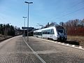
S-Bahn in Lichtentanne (2016)

Lichtentanne, old reception building (2016)

.JPG)
.JPG)

Personalities
- Friedrich August Barth (1816–1879), farmer in Stenn and conservative politician, member of the state parliament in the Kingdom of Saxony
- Ernst Sünderhauf (1908–1974), politician (SPD), head of the Berlin Senate Chancellery
- Christoph Schmelzer (1908–2001), nuclear physicist
- Horst Gärtner (1911–2001), hygienist
Web links
- Lichtentanne in the Digital Historical Directory of Saxony
- Official website
Individual evidence
- ↑ Population of the Free State of Saxony by municipalities on December 31, 2019 ( help on this ).
- ↑ The Lichtentanne manor at www.sachsens-schlösser.de
- ↑ The Thanhof Manor at www.sachsens-schlösser.de
- ↑ Schönfels Castle at www.sachsens-schlösser.de
- ↑ Leubnitz Castle at www.sachsens-schlösser.de
- ↑ Lichtentanne in the "Handbuch der Geographie", p. 134
- ^ Karlheinz Blaschke , Uwe Ulrich Jäschke : Kursächsischer Ämteratlas. Leipzig 2009, ISBN 978-3-937386-14-0 ; P. 64 f.
- ↑ The Zwickau administrative authority in the municipal register 1900
- ^ Michael Rademacher: German administrative history from the unification of the empire in 1871 to reunification in 1990. City and district of Zwickau. (Administrative structure in the Zwickau area around 1939; online material for the dissertation, Osnabrück 2006).
- ↑ Thanhof on gov.genealogy.net
- ^ Brand on gov.genealogy.net
- ↑ Maxhütte and Brand on the website of the community of Lichtentanne
- ^ Norbert Peschke: Bombs on Zwickau and Planitz . Sutton 2003
- ^ Community of Lichtentanne: Community of Lichtentanne. Retrieved July 24, 2017 .
- ↑ Municipalities 1994 and their changes since January 1, 1948 in the new federal states , Metzler-Poeschel publishing house, Stuttgart, 1995, ISBN 3-8246-0321-7 , publisher: Federal Statistical Office
- ↑ Directories of the municipalities incorporated since May 1945 and evidence of the breakdown of the independent manor districts and state forest districts, 1952, publisher: Ministry of the Interior of Saxony
- ↑ a b c State Statistical Office of the Free State of Saxony: Area changes
- ↑ "% 23tab seat distribution"% 3A1% 7D
- ↑ http://www.freipresse.de/LOKALES/ZWICKAU/ZWICKAU/Lichtentanne-Tino-Obst-gewinnt-die-Wahl-zum-Buergermeister-artikel9850320.php
- ↑ Municipality of Lichtentanne - partner municipalities , accessed on May 13, 2018