
Crinitzberg
| coat of arms | Germany map | |
|---|---|---|

|
Coordinates: 50 ° 34 ' N , 12 ° 30' E |
|
| Basic data | ||
| State : | Saxony | |
| County : | Zwickau | |
| Management Community : | Kirchberg | |
| Height : | 460 m above sea level NHN | |
| Area : | 18.81 km 2 | |
| Residents: | 1874 (Dec. 31, 2019) | |
| Population density : | 100 inhabitants per km 2 | |
| Postal code : | 08147 | |
| Area code : | 037462 | |
| License plate : | Z, GC, HOT, WDA | |
| Community key : | 14 5 24 040 | |
| Community structure: | 3 districts | |
| Address of the municipal administration: |
Auerbacher Strasse 51 08147 Crinitzberg |
|
| Website : | ||
| Mayor : | Steffen Pachan (WV / BÜKO) | |
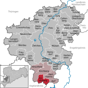
| Location of the municipality of Crinitzberg in the district of Zwickau | ||
  |
||

The municipality of Crinitzberg with its districts of Bärenwalde , Lauterhofen and Obercrinitz is located in the Saxon district of Zwickau . It belongs to the administrative community of Kirchberg .
geography
Geographical location
Bärenwalde is located in the Rödelbachtal . Obercrinitz and Lauterhofen are in the neighboring Crinitztal . Between Obercrinitz and Bärenwalde there is the eponymous Crinitzberg ( 573 m above sea level ), which separates the two valleys. The places are in the Kirchberg granite area at an altitude of 400 to 610 m above sea level. NN . Schneeberg is 10 km northeast, Reichenbach 16 km west and Zwickau 19 km north.
Neighboring places
Adjacent cities and towns are
- in the district of Zwickau: Kirchberg and Hartmannsdorf near Kirchberg
- in the Erzgebirge district: Stützengrün
- in the Vogtlandkreis: Steinberg
| Wolfersgrün | Giegengrün | Hartmannsdorf near Kirchberg |
| Pole green |
.svg)
|
Felt pond |
| Wildenau | Rothenkirchen | Lichtenau |
Community structure
Crinitzberg consists of three districts:
- Bear forest
- Obercrinitz with Herlagrün
- Lauterhofen with Lauterholz
history
Incorporations
In 1912 Lauterholz was reassigned from Hirschfeld to Lauterhofen. In 1950 Herlagrün was changed from Wildenau to Obercrinitz . In 1970 Lauterhofen was incorporated into Obercrinitz. In 1994 Obercrinitz and Bärenwalde merged to form the new municipality of Crinitzberg, with Lauterhofen regaining its district status.
politics
Municipal council
Since the municipal council election on May 25, 2014 , the 14 seats of the municipal council have been distributed among the individual groups as follows:
- Free voters Crinitzberg (BÜKO): 11 seats
- CDU : 3 seats
mayor
Mayor of Crinitzberg is Steffen Pachan.
Local partnerships
A partnership with Alsbach-Hähnlein in Hesse has existed since September 1991 . The Hähnlein and Obercrinitz volunteer fire brigades have also had partnerships since 1992. The Bärenwalder volunteer fire brigade, however, is in contact with the Modautal community , which, like Alsbach-Hähnlein, is also in the Darmstadt-Dieburg district .
Religions
The ev.-luth. Parish Bärenwalde and the neighboring town of Lichtenau in the Erzgebirge district belong to a parish with the parish in Hartmannsdorf near Kirchberg in the parish of Zwickau. The Ev.-Luth. The parish of St. Johannis in Obercrinitz with Lauterhofen forms a sister church relationship with the neighboring parishes in Wildenau and Stangengrün within the Ephorie Zwickau. In Obercrinitz there is still a regional church community and a brother community.
Public facilities
The municipality of Crinitzberg is located in the Bärenwalde district. There has also been a branch of the city of Kirchberg there since 2004 , with which Crinitzberg has an administrative community.
education
There is a privately owned primary school in Bärenwalde. The Obercrinitz Middle School was closed in the middle of the first decade of the 21st century.
traffic
Bärenwalde is located in the Rödelbachtal on the road from Kirchberg to Rothenkirchen . Obercrinitz and Lauterhofen are in the neighboring Crinitztal. Since 1893, Bärenwalde and Obercrinitz had a station each with a connection to the Wilkau-Haßlau-Carlsfeld narrow-gauge railway . The line was closed on the section between Saupersdorf bei Kirchberg and Rothenkirchen in 1970.
Economy and Infrastructure
There is an industrial park in the municipality of Crinitzberg.
Personalities
Sons and daughters of the church
- Rudolf Dittrich (* 1855 in Bärenwalde, † 1929 in Leipzig ), politician, Lord Mayor of Plauen (1893 to 1900) and Leipzig (1908 to 1917)
- Gertrud Drechsler (* 1896 in Bärenwalde, † 1984 in Kirchberg), dialect poet of the western Ore Mountains .
- Gottfried K. Wehner (* 1910 in Bärenwalde, † 1996 in Gauting), physicist
- Frank Bretschneider (* 1956 in Obercrinitz), musician and video artist
See also
Web links
- Website of the municipality of Crinitzberg [1]
- Crinitzberg in the Digital Historical Directory of Saxony
- Bärenwalde in the Digital Historical Directory of Saxony
- Obercrinitz in the Digital Historical Directory of Saxony
- Herlagrün in the Digital Historical Directory of Saxony
- Lauterhofen in the Digital Historical Directory of Saxony
- Lauterholz in the Digital Historical Directory of Saxony
Individual evidence
- ↑ Population of the Free State of Saxony by municipalities on December 31, 2019 ( help on this ).
- ↑ Lauterholz in the index of places. In: Digital Historical Directory of Saxony. 2006, accessed November 21, 2011 .
- ↑ Results of the 2014 municipal council elections