Rödelbach (Zwickauer Mulde)
| Rödelbach | ||
|
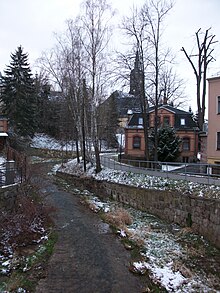
Rödelbach with the former narrow-gauge railway bridge in Kirchberg |
||
| Data | ||
| Water code | EN : 5414 | |
| location | Saxony , Germany | |
| River system | Elbe | |
| Drain over | Zwickauer Mulde → Mulde → Elbe → North Sea | |
| source | East of Rothenkirchen 50 ° 32 ′ 5 ″ N , 12 ° 30 ′ 33 ″ E |
|
| Source height | 620 m above sea level NN | |
| muzzle | In Wilkau in the Zwickauer Mulde coordinates: 50 ° 40 '32 " N , 12 ° 30' 58" E 50 ° 40 '32 " N , 12 ° 30' 58" E |
|
| Mouth height | approx. 280 m | |
| Height difference | approx. 340 m | |
| Bottom slope | approx. 15 ‰ | |
| length | approx. 22 km | |
| Left tributaries | Kuhbach, Giegengrüner Bach, Crinitzer Wasser , Plotzschbach | |
| Right tributaries | Friedrichsbach, Burkersdorfer Bach | |
| Flowing lakes | Herrenteich near Stangengrün , Filzteich near Niedercrinitz (at tributaries) | |
| Reservoirs flowed through | Wolfersgrün Dam (on the Crinitzer Wasser) | |
The Rödelbach is an approximately 22 km long left tributary of the Zwickauer Mulde on the edge of the Western Ore Mountains in the Free State of Saxony .
course
The Rödelbach with its valley separates the Kirchberg granite area on the left bank from the Hartmannsdorfer Forst on the right bank. Like its tributaries, the Giegengrüner Bach and the Crinitzer Wasser, located in the Kirchberg granite area, it runs from south to north.
The source of the Rödelbach is located in the Steinberg district of Rothenkirchen on the eastern edge of the Vogtland . First it flows to the northeast and takes on the Rosentalbach near Stützengrün (in the Western Ore Mountains ) . Then the Rödelbach touches the town of Rothenkirchen, is dammed to the Rabensteinteich and at the lower end of the town takes up the Kuhbach flowing through Rothenkirchen . After the confluence, the stream reaches the border of the Zwickau district . It crosses the Crinitzberg district of Bärenwalde , takes on the Friedrichsbach at the lower end of the village and continues through Hartmannsdorf and the Kirchberg districts of Saupersdorf , Kirchberg and Cunersdorf . In Kirchberg the Burkersdorfer and the Giegengrüner Bach flow , in Cunersdorf the Crinitzer Wasser into the Rödelbach. After Cunersdorf the brook flows briefly through a floodplain and reaches the row of houses " Siedlung am Hochwald ", which belongs to the Wilkau-Haßlauer district of Culitzsch . After taking up the Plotzschbach , the Rödelbach flows into the Zwickauer Mulde in the Wilkau district near the train station .
Tributaries
The Rödelbach is characterized by numerous tributaries. While the right tributaries arise in the Hartmannsdorfer Forst , most of the left tributaries and their numerous tributaries are located in the Kirchberg granite area .
Right tributaries
- Friedrichsbach (GKZ: DE / 54142) : The Friedrichsbach rises in the Stützengrün district of Lichtenau on the edge of the Hartmannsdorfer Forest and flows into the Rödelbach at the border of Bärenwalde and Hartmannsdorf .
- Burkersdorfer Bach: The Burkersdorfer Bach rises in the Kirchberg district of Burkersdorf on the edge of the Hartmannsdorfer forest , flows through the lower district of Burkersdorf and flows into the Rödelbach in Kirchberg .
Left tributaries
- Kuhbach : The Kuhbach rises near the former train station in Rothenkirchen , flows through the entire village and flows into the Rödelbach at the local border with Bärenwalde .
- Giegengrüner Bach (GKZ: DE / 54144) : The Giegengrüner Bach has its source in the Hartmannsdorf district of Giegengrün in the Kirchberg granite area and is fed by several ponds. It flows in a parallel valley between Crinitzer Wasser in the west and Rödelbach in the east. It passes the Kirchberg district of Leutersbach and flows into the Rödelbach in the center of Kirchberg .
- Crinitzer Wasser (GKZ: DE / 54146) : The Crinitzer Wasser rises in the forest north of Rothenkirchen and flows further through the Crinitztal, which runs parallel to the Rödelbach. It passes the Crinitzberg districts of Herlagrün , Obercrinitz , Lauterhofen and the Kirchberg district of Wolfersgrün . To the north of Wolfersgrün, the stream isdammedin the mouth of the Hirschfelder Water to form the Wolfersgrün dam. Then it flows through the Hirschfeld district of Niedercrinitz and flows into the Rödelbachin the Kirchberg district of Cunersdorf .
Larger tributaries of the Crinitzer water are next to the Hirschfelder Wasser with its source rivers Irfersgrüner and Stangengrüner Bach , the Burkertsbach with the Herrenteich, the Voigtsbach and the Niedercrinitzer Lohbach with the Filzteich near Niedercrinitz.
- Plotzschbach (GKZ: DE / 54148) : The Plotzschbach rises west of the Zwickau district of Rottmannsdorf and flows north of the Autobahn 72 to Wilkau-Haßlau after crossing the town , where it flows into the Rödelbach near the motorway bridge in the Wilkau district. The only notable tributary is the Culitzschbach west of the Wilkau-Haßlauer district of Culitzsch .
history
From 1881, the lower part of the Wilkau-Haßlau-Carlsfeld narrow-gauge railway ran through the Rödelbachtal . The construction of the railway line was closely linked with the flourishing textile industry and the management of the quarries in the Rödelbachtal. The railway line was closed in 1967 for the Kirchberg-Saupersdorf section. In 1970 the Saupersdorf Rothenkirchen section was canceled and in 1973 the last section in the Rödelbachtal between Kirchberg and Wilkau-Haßlau.
In order to improve the drinking water supply in the Zwickau area, plans were made in the 1940s to dam the Crinitz water above the Quarksteine between Wolfersgrün and Niedercrinitz to form a dam. Of the plans, however, only one preliminary barrier was implemented, today's Wolfersgrün dam .
See also: List of waters in Saxony


