Culitzsch
Culitzsch has been part of Wilkau-Haßlau in the district of Zwickau in Saxony since the municipal reform of January 1, 1999 .
geography
Geographical location
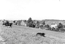
The village is located at the foot of the Ore Mountains on the old road connecting Wilkau and Kirchberg near the border with the Vogtland .
The highest point is 396 m above sea level. NN located Pompersberg in the south of the place. The Plotzschgrund, a local recreation area for the people of Zwickau and their surroundings, extends to the west .
Since the late thirties, the A 72 has cut through the town and crossed the Niederdorf with a bridge.
geology
Located between the Kirchberger and Planitz granite plinths, slate forms the subsoil for the mountain ridge of Bauersberg and Pompersberg .
Neighboring communities
Neighboring places are in the north Wilkau-Haßlau, in the west Cainsdorf and Rottmannsdorf (today both incorporated into Zwickau ) in the south Niedercrinitz (today part of Hirschfeld ) and in the east Cunersdorf (now Kirchberg / Sa. Added).
structure
The village consists of the low settlement with the settlement on Plotzschgrund , the upper village and settlement on the Hochwald , on the valley road in Rödelbachtal , the new connection between Wilkau-Haßlau and Kirchberg, at the earlier of the breakpoint Culitzsch the narrow-gauge railway Wilkau-Haßlau-Carlsfeld was .
history
Culitzsch is of Slavic origin, which can already be deduced from its name. The hypothesis of a spring trough settlement is unclear, because the west side of the place is more reminiscent of a Waldhufendorf . A Slavic settlement is said to have been at the current location of the church.
The place was settled around 1250 . He was first mentioned in 1288 under the name of Culicz . In 1463 and 1544 the name of the place was written as Gulitzsch , which hardly differs from today's spelling in the pronunciation of the locals. It was not until 1610 that the place name can be found in the spelling used today. Culitzsch means "place of Clojek" (Clojek is the name of a Slavic settler).
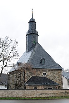
Around 1300 Pope Clemens V founded a pilgrimage church in Culitzsch. This church probably stood in the middle of the village. It was destroyed by fire and demolished in 1770 . On May 29, 1770 the foundation stone was laid for the Laurentiuskirche. It was built by the Schneeberg master builder August Siegert and consecrated in 1773 . It is a massive quarry stone building covered with slate
In 1560 the first school house was built and it was destroyed in a fire. The communities of Culitzsch and Wilkau jointly built a new school in 1671, which also burned down. The school building, built in 1771 , has been preserved to the present day. In 1899 a new school building was built and inaugurated in 1900 . It is currently no longer used as a school. An association founded specifically for the purpose is actively trying to restore the building to a functional use.
Culitzsch has been a farming village since it was founded. After the start of industrial coal mining in Zwickau and the boom in the iron industry through the Queen Marienhütte in neighboring Cainsdorf, there was also an upturn in employment in Culitzsch in the 19th century. Workers settled in the place. In 1899 Paul Kiesel from Wilkau an der Plotzsch built a factory in which knitting machines were installed. The later owners were Heinz and Riedel. The Ernst Kästner company produced until 1956 , later it was part of the VEB Plauener Spitze . In 1991 production was stopped.
On January 1, 1999, Culitzsch was incorporated into the city of Wilkau-Haßlau.
Population development
Culitzsch had the largest population after the Second World War with almost 1500 inhabitants. There are currently around 500.
Sports, culture and sights
Culture and sights
- Laurentiuskirche with an altar by Peter Breuer
- the Plotzschbach in the Grund of the same name with the Schauersbrünnl (also known as the Jägerbrünnlein), the water of which flows over the Rödelbach into the Zwickauer Mulde
- extensive hiking opportunities around the frog pond in the Plotzschgrund nature reserve
- Monument commemorating the victims of the world wars
- Bridge of the A72 motorway over the local area of Culitzsch
- Culitzsch Oldtimer Museum
Sports
- Motocross track of MC Culitzsch, which has its origins in the community of motor sports enthusiasts in the region and has found its domicile in the village thanks to the track created
- the Wilkau-Haßlauer Herbertbad on the local border with Culitzsch
literature
- Hugo Leitpoldt: History of the Culitzsch parish with Niedercrinitz 1300-1900 . Kandel, Kirchberg 1900 ( digitized version )
- Werner Leichsenring: Family book for the parish of Culitzsch (with Niedercrinitz and Wilkau) 1599-1799 based on a card index from around 1970. Copy of the family cards . Leipzig: German Central Office for Genealogy 1994; 929 families
Web links
- Website of the city of Wilkau-Haßlau
- Culitzsch in the Digital Historical Directory of Saxony
Individual evidence
- ↑ Georg Dehio et al .: Handbook of German Art Monuments. Saxony II. Administrative districts Leipzig and Chemnitz . Deutscher Kunstverlag, Munich 1998, pp. 170–171
- ↑ StBA: Changes in the municipalities in Germany, see 1999
- ↑ http://www.htc-ev.de/Historische_Technik_Culitzsch.html
Coordinates: 50 ° 39 ′ 31 ″ N , 12 ° 30 ′ 34 ″ E


