
Zwickauer Mulde

.jpg)
The Zwickauer Mulde is a river in the south-west of Saxony with a general north-east flow direction. It arises from two source rivers near Schöneck / Vogtland and forms the combined Mulde near Colditz together with the Freiberger Mulde flowing in from the southeast . The Zwick Auer well is 167 kilometers of the longer of the two source fluxes, but less with a water flow of 26.4 m³ / s as the Freiberger trough.
Geography and hydrology
course


The Zwickauer Mulde is formed from two source streams, the Rote Mulde and the White Mulde , both in the area of the town of Schöneck in Vogtland at 770 m above sea level. NHN . The Rote Mulde is the main source river. Both flow into the Muldenberg dam , which is also fed by the Saubach. From the confluence of these three brooks, the Zwickauer Mulde flows mainly in a north-easterly direction through a wooded area and through the towns of Muldenberg , Hammerbrücke and Morgenröthe-Rautenkranz .
In the upper catchment area there is an average gradient of 8.8 ‰.
After the river has crossed in a narrow valley into the Western Ore Mountains, it is dammed over a large area at the Eibenstock dam.
At Aue the Zwickauer Mulde absorbs the black water and turns to the northwest. The Mulde then passes Hartenstein , Fährbrücke and Wiesenburg with the former waterworks of the city of Zwickau. From Silberstraße the federal highway 93 follows the valley of the Mulde. In Wilkau-Haßlau the A 72 crosses the valley with a 718 m long and 50 m high bridge.
Before the Mulde flows east around the city center of its namesake Zwickau , it forms rapids in the district of Cainsdorf , formerly the scene of international kayak slalom competitions , today protected as a geotope because coal seams come to light here . In the district of Schedewitz the river crosses the flint line , which shows the southern edge of the Elster glaciation.
After the Mulde has left the Ore Mountains near Zwickau, the valley becomes wide with wide retention areas in meadows and fields. This is where the VW Mosel plant and the city of Glauchau , where the Lungwitzbach flows, are located. The valley, which is now becoming narrower and rocky again, is occupied by numerous castles and continues to be densely populated with the towns of Waldenburg , Penig , Rochsburg , Lunzenau and Rochlitz . The A 72 crosses the Mulde near Penig ; the bridge was inaugurated in 2011. In the vicinity of Wechselburg the river takes by far its largest tributary, the Chemnitz . Near the Wechselburg district of Göhren , the Leipzig-Chemnitz railway line crosses the valley at a height of 68 meters in the two-story Göhren viaduct .
After 167 kilometers of running, the Zwickauer Mulde joins the Freiberg Mulde to form the Mulde on the outskirts of the Colditz district of Sermuth . A route of the Muldentalradwanderweg runs along the river .
Catchment area
The 2,352 km² catchment area of the Zwickauer Mulde includes large parts of the western Ore Mountains and the Vogtland. It is elongated, so that the Zwickauer Mulde is the longer source river of the Mulde, but the Freiberger Mulde is the richer one because of its wider catchment area.
Discharge regime and dam system

.jpg)
The Zwickauer Mulde with its tributaries was hardly regulated until the first half of the 20th century and repeatedly caused devastating floods. In 1954 cities and villages were ravaged by a flood disaster. In the course of the 20th century, a dam system was created that is of great importance for the drinking water supply and flood protection of the Western Ore Mountains: After the construction of the Muldenberg dam in 1925, the Carlsfeld dam in 1929, which dammed the Wilzsch , the Sosa dam was created in 1952 , which dams the water of the Große Bockau , and finally the large Eibenstock dam (28 kilometers below Muldenberg) with the Schönheiderhammer dam and the Rähmerbach basin , which were completed in 1982. The damage caused by the flood of the century in 2002 was therefore still limited on the Zwickauer Mulde. The Eibenstocker dam lowered the peak discharge during this flood from 180 m³ / s to 55 m³ / s. The Eibenstock dam overflowed for the first time since its trial damming during commissioning, which also happened again during the 2013 flood .
It has been handed down from centuries past that the river bed dried up at least twice during periods of extreme drought. The Eibenstock dam now ensures the ecologically required minimum discharge of 0.50 m³ / s.
history
Natural development
.jpg)
The Mulde flows through the central part to about Rochlitz the Mittelsächsische mountains and hills with rocks that far ahead of the Variscan orogeny emerged ( Granulitgebirge ) . Below Wechselburg rises on the left bank of the 353 m above sea level. NHN high Rochlitzer Berg , a remnant of a stratovolcano from the rock unit of the Rotliegend known for its porphyry tuff . The area has been land-based since the Mesozoic .
During the uplift and tipping of the Ore Mountains to the northwest in the manner of a rock clod in the course of the Saxon clod tectonics , today's north-facing drainage system developed, occasionally with marked changes of direction to the north-west. The valley line of the Zwickauer Mulde above the north-west bend near Aue continues further north in the Zwönitz valley. These changes of direction are partly attributed to the damming margins of Scandinavian inland ice during older ice ages . Glacial deposits from the Elster glaciation are only preserved in remnants. More than 25 m thick, flint-bearing sands and gravels near Wechselburg are seen as cold-time deposits from an old Muldelauf. The widespread loess , the cause of the region's fertile soils , originates from the Vistula glacial period , which ended around 10,000 years ago . Thereafter, river gravel and sand as well as alluvial clay settled in the valley floor.
Cultural landscape development
The valleys in the catchment area of the Mulde have probably been used as access points into the Ore Mountains, which are covered by dense primeval forests, since the end of the last glacial period, as evidenced by the remains of settlements of Paleolithic hunters, as well as Bronze and Iron Age finds as far as the Upper Ore Mountains.
Later the Western Ore Mountains belonged to the area of Germanic and Slavic tribes. Paths, trade routes and military roads connected the old settlement areas around Leipzig and Altenburg with Bohemia. The mule tracks, however, avoided the rivers in favor of the ridges. At inevitable river crossings ( fords , later with ferries and bridges) and at crossroads, castles, villages and monasteries developed. Some of the medieval castles were expanded into palaces in later epochs. The historical chain of castles includes (in the direction of the current from south to north):


- Schwarzenberg Castle (on the Schwarzwasser near its confluence with the Zwickauer Mulde)
- Isenburg
- Hartenstein Castle
- Stein Castle
- Wiesenburg
- Osterstein Castle (Zwickau)
- Fordglauchau Castle and Hinterglauchau Castle
- Remse monastery
- Waldenburg Castle
- Wolkenburg Castle
- Old Penig Castle
- Rochsburg Castle
- Wechselburg castle stable (together with the monastery and later the baroque castle Wechselburg )
- Rochlitz Castle
- Colditz Castle
From Hartenstein to Wechselburg, all of these castles - with the exception of Wiesenburg, Zwickau and Wolkenburg - belonged to the Schönburg rulers . Wildenfels Castle was built in a side valley above a stream that flows into the Zwickauer Mulde near Wiesenburg . From the confluence with the Freiberg Mulde , which - like the Zschopau that flows into it - is accompanied by a comparable chain of castles, the chain continues along the Mulde to the confluence with the Elbe at Roßlau Castle .
When the abundant silver deposits became known in the late Middle Ages, the development of the source streams in the upper Ore Mountains and the development of the mining towns began .
Origin of name
Albrecht Greule sees the two rivers that combine to form the Mulde, Freiberger Mulde and Zwickauer Mulde, originally two river names in accordance with the geographical conditions. The Old High German word "Milda / Milta" (meaning water-rich) as probably for the Freiberger Mulde and the also Old High German "Mold-aha" for the Zwickauer Mulde. "Mold-aha" is a compound with the basic word "aha", which comes from Old High German, meaning flowing water and the Germanic term "muldo" for dust, earth. This word would exist in Gothic as “mulda”, in Old West Nordic as “mold”, in Old English as “molde” and in Old High German as “molta”. The word component Mel with reference to grinding is sometimes associated with the large number of mills that used to be operated on the river, disregarding the fact that river names represent the oldest, often pre-Germanic, geographical layer of names.
The distinctive addition to the name refers to the city of Zwickau as the largest settlement along the river. The Zwickauer Mulde was formerly called Schneebergische or Schneeberger Mulde, for example by Christian Lehmann in 1699 and still in 1819 in Latest News from the Kingdom of Saxony .
environment
Water structure

The river is hardly obstructed over long stretches of the upper and middle reaches. In near-natural floodplains, the trough flows with changing flow speeds in an initially block-rich, later gravel to sandy river bed. (The river sand, like that of the Göltzsch, has a low gold content .) The river is canalised in a few sections. In populated areas it is often accompanied by flood protection dikes , such as in the entire urban area of Zwickau, where the historic city center is now deeper than the river bed due to mountain subsidence . Flood events (especially in August 2002) cause natural changes in the water structure with bank breaks and sediment deposits.
Water quality
For over two centuries until the 1990s, the Zwickauer Mulde was so heavily polluted, especially in the lower sections, by the discharge of increasing amounts of poorly or unclarified wastewater , some of which contained heavy metals , that the fish fauna was almost extinct. The water quality has improved considerably after the reunification of Germany due to the shutdown of numerous industrial plants , so that today the water quality class II-III (critically polluted) is characteristic. The Zwickauer Mulde drains the metal processing and mining areas of the western Ore Mountains, as well as the industrial regions around Chemnitz and Zwickau. The pit water that is now escaping after most of the mines have been flooded is particularly problematic. Below Bad Schlema, the river absorbs a large part of its load of uranium , arsenic and other dissolved heavy metals through seepage water from the spoil heaps of the former bismuth shaft 371 .
Sights and buildings
- Eibenstock dam
- Prinzenhöhle in the valley slope in the Poppenwald below Bad Schlema, hiding place of Prince Ernst of Saxony during the Altenburg prince robbery
- Stein Castle
- Annual rafting in the Muldenberger raft ditch system
- Above Zwickau, in Cainsdorf , the Mulde cuts the soot-coal seam . This is the only continuously exposed outcrop of a coal seam in Saxony and an outcrop of three geological ages ( Silurian , Devonian Upper Carboniferous ), which is rare in Central Europe , and is protected as a geotope and geological natural monument.
- Osterstein Castle in Zwickau
- Crossing of the road bridge (formerly B95) over the Zwickauer Mulde, the railway bridge ( Glauchau – Wurzen railway line ) and the motorway bridge over the Zwickauer Mulde ( federal motorway 72 ) in three levels between Thierbach and Penig
bridges
Röhrensteg in Zwickau, oldest of the three historic wooden bridges in Saxony (approx. 1535, since 1790 in its current form)

Bridge of the former B 95 near Penig

Bridge of the A 72 near Penig

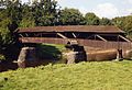
The Göhrener Viaduct over the valley of the Zwickauer Mulde (built in 1871)

Porphyry bridge over the Zwickauer Mulde near Wechselburg

Last bridge of the Zwickauer Mulde before the confluence with mushroom in the coat of arms

.jpg)


economy
_2006-10-30.jpg)
The water of the Mulde and its tributaries has been used technically since the late Middle Ages . It served the mining industry for many centuries as a supplement water for driving conveyors, Erzhämmern and Pochwerken and for Erzwäschen .
rafting
The wood hits , the rafting, is documented for the first time in 1275 and took place during times of higher water flow not only on the river, but also on the historical raft ditches, some of which are still recognizable, some of which are even functional like the raft ditch at Schlema or the Muldenberger raft ditch system. The raft ditch at Schlema between Albernau and Schlema was built as early as 1556–1560 and was used exclusively for rafting wood. It got its water from the hollow and ran parallel to the river. The rafted trunks were salvaged from the river near Zwickau with the help of rakes and stacked on the so-called Holzanger. Grundig and Klotzsch report in 1771 under the heading Zwickauische Muldenflüsse : “Such is one of the oldest in the country, of which one has news, and it is owned by the local council because of the privileges to be had. Utility and fuel wood is rafted on it and brought to the benefit of the city of Zwickau. ” Time and again, aristocratic neighbors have denied the Zwickau privileges - sometimes for years - by collecting customs for rafting through their territory and rafting by installing Tried to avoid obstacles entirely. The city of Zwickau had to overcome these difficulties by paying cash. In 1486, Elector Friedrich the Wise confirmed the Zwickau privileges. The city of Zwickau had created several storage ponds ( “three very large raft ponds” ) in the Vogtland to ensure rafting when the water level in the river is low by draining water from these reservoirs .
The town of Schneeberg had had rafting rights in the Mulde area from 1539 at least from the mouth of the Wilzsch to the Aue . The removal of tree trunks from areas in the area of the Wilz estuary and drainage by the city of Schneeberg in 1641 led to legal disputes.
Theft of wood that was rafted on the Mulde prompted Elector August the Strong to issue special regulations to combat thieves. On April 10, 1710, the “Mandate against the Holzdeuben on the Wilzsch and Mulden streams” was issued . Later there was the raft inspection of the Saxon elector for the Wilzsch and Mulden rafts with an electoral Saxon head supervisor and an electoral Saxon raft master , which was already included in the first court and state calendar of Saxony of 1728 Names are listed. In 1839 Albert Schiffner reported on the use of the trough for rafting.
Fishing, energy and drinking water production
Numerous families were able to live from the abundance of fish in the river. With increasing water pollution in the course of industrialization in the 19th and 20th centuries, fishing came to a standstill. Today the water quality has improved significantly. However, the large number of barrages makes it difficult to reintroduce the natural fauna. In the summer months of the last few years, some systems repeatedly fell below the minimum residual water levels and even individual river sections fell dry.
Even today, numerous weirs are in operation, most of which are used to generate electricity.
The Muldentalsperren in the Ore Mountains supply the Chemnitz-Zwickau agglomeration with drinking water today .
See also
- Muldentalbahn
- Chemnitz – Adorf railway line
- List of bodies of water in Saxony
- Floods and natural disasters in Saxony
literature
- Hermann Grimm: The picturesque and romantic Mulden highlands or hikes through the valleys of both Mulden and their tributaries. Secondary title: The Saxon Ore Mountains in a picturesque, historical and artistic way. A guide for mountain friends and art lovers. Digitized with 50 steel engravings based on original drawings by CJ Leypold and Carl Heinrich Beichling and 1 card, published by HH Grimm, Dresden 1847
- Albert Schiffner : The leader in the Muldenthale, from the Voigtland heights to the union of the two hollows . In 16 deliveries, containing 37 views, taken from nature by Gustav Täubert, lithographed by J. Riedel, Verlag von Gustav Täubert, Dresden (no year, 1848) ( digitized in the Leipzig University Library )
- Between Zwickauer Mulde and Geyerschem Wald (= values of our homeland . Volume 31). 1st edition. Akademie Verlag, Berlin 1978.
- Thomas Böttger: The Mulde: A journey through pictures along the fastest river in Europe . Bildverlag Böttger, Witzschdorf 2009
- International Commission for the Protection of the Elbe: The Elbe and its catchment area - a geographical, hydrological and water management overview , Chapter 4.6 - The Mulde, no year, published after 2002 in digital form
Web links
Individual evidence
- ↑ Topographic map 1: 25,000
- ↑ Report of the independent commission of the Saxon state government flood catastrophe 2002 ( Memento of the original from August 16, 2010 in the Internet Archive ) Info: The archive link was automatically inserted and not yet checked. Please check the original and archive link according to the instructions and then remove this notice. (PDF; 903 kB)
- ^ German Hydrological Yearbook Elbe Region, Part I 2014. (PDF) State Office for Flood Protection and Water Management Saxony-Anhalt, p. 134 , accessed on November 3, 2018 (from: lhw.sachsen-anhalt.de).
- ↑ The mean discharge of the Zwickauer Mulde estuary is determined from the values of the level Wechselburg 1 (Zwickauer Mulde) and indirectly Golzern 1 (Mulde) and Erlln (Freiberg Mulde). For the intermediate catchment area below Wechselburg, the area discharge was determined from the water level data and multiplied by the catchment area of the Zwickau Mulde below the Wechselburg 1 water level.
- ↑ a b c d International Commission for the Protection of the Elbe: The Elbe and its catchment area - a geographic, hydrological and water management overview , Chapter 4.6 - The Mulde, n.d., published after 2002, p. 115 digitized version ( Memento des original from May 6, 2016 in the Internet Archive ) Info: The archive link was inserted automatically and has not yet been checked. Please check the original and archive link according to the instructions and then remove this notice.
- ↑ a b International Commission for the Protection of the Elbe: The Elbe and its catchment area - a geographic, hydrological and water management overview , Chapter 4.6 - The Mulde, n.d., published after 2002, p. 116 digitized version ( Memento des original from 6. May 2016 in the Internet Archive ) Info: The archive link was inserted automatically and has not yet been checked. Please check the original and archive link according to the instructions and then remove this notice.
- ^ Albrecht Greule : German water names book . Etymology of the names of waters and the associated area, settlement and field names, Verlag Walter de Gruyter, Berlin 2014, ISBN 978-3-11-033859-1 , p. 363 ( digitized version ), s. also Albrecht Greule: From Memoria to Cognitive Notepad. Name types and memoria . In: Nomen et Fraternitas: Festschrift for Dieter Gruenich for his 65th birthday . Berlin 2008, ISBN 978-3-11-020238-0 , p. 201
- ↑ [1] Christian Lehmann: Natur-Chronik, published as: Historical scene of their natural peculiarities in the Meißnischen Ober-Ertzgebirge, Leipzig 1699, published as digital copy by the Bayerische Staatsbibliothek, accessed on January 14, 2014
- ↑ Latest regional and ethnographic studies: A geographical reader for all classes. Latest news from the Kingdom of Saxony, edited from good sources . In the publishing house of the GHS privil. State industrial comptoirs. Weimar 1819, page 38, digitized , accessed on January 6, 2015
- ↑ Ordinance of the district-free city of Zwickau for the establishment of the geological natural monument (# 5) coal outcrop (soot coal seam) on the Muldenufer at the Cainsdorfer Bridge of January 27, 2000 (according to § 21 of the Saxon Nature Conservation Act (SächsNatSchG) )
- ^ Council of the community of Bockau : FDGB vacation resort Bockau / Erzgeb. Hiking guide for Bockau / Erzgeb. und Umgebung, Bockau o. J. (1964), p. 28
- ^ H. Wilsdorf, W. Herrmann, K. Löffler: Mining - Forest - Floats . Freiberg research books, D28. Berlin 1960.
- ↑ a b c Gottfried Immanuel Grundig and Johann Friedrich Klotzsch : Collection of mixed news on Saxon history , Volume 6, bey Johann Christoph Stößel, Chemnitz 1771 p. 251 f. Digitized version , accessed on August 23, 2015
- ↑ Thank God Immanuel Merkel: Earth description of Electoral Saxony and the countries belonging to it . Third volume. Third, improved and increased edition. Edited by Karl August Engelhardt, member of the electoral prince. Saxon. Upper Lusatian Society of Sciences. Dresden-Friedrichstadt from the author and Leipzig from Barth, 1804, p. 61 digitized , accessed on 23 August 2015
- ^ Ernst Flath: Local history and history of Schönheide, Schönheiderhammer and Neuheide , Schönheide o. J. (1909), p. 273 Digitized in the Dresden State and University Library
- ^ Ernst Flath: Local history and history of Schönheide, Schönheiderhammer and Neuheide , Schönheide o. J. (1909), p. 272 Digitized in the Dresden State and University Library
- ^ Karl Gotthold Merbeth: Chronological register of both in the Codex Augusteus and in the collection of laws for the Kingdom of Saxony , Verlag von Johann Ambrosius Barth, Leipzig 1834, p. 79 digitized , accessed on August 24, 2015
- ↑ Royal. Polish and Elector Saxon. Hoff and Staats calendar to the year 1728 . To be found in Weidmannische Buchladen, Leipzig 1728, unpag. ( Digitized version of the relevant page in the digital collections of the Duchess Anna Amalia Library in Weimar )
- ^ Albert Schiffner: Handbook of geography, statistics and topography of the Kingdom of Saxony . First delivery, containing the Zwickau directions district, from Friedrich Fleischer Leipzig 1839, p. 409 digital copy , accessed on August 22, 2015