
Chemnitz – Adorf railway line
| Chemnitz central station - Adorf (Vogtl) | |||||||||||||||||||||||||||||||||||||||||||||||||||||||||||||||||||||||||||||||||||||||||||||||||||||||||||||||||||||||||||||||||||||||||||||||||||||||||||||||||||||||||||||||||||||||||||||||||||||||||||||||||||||||||||||||||||||||||||||||||||||||||||||||||||||||||||||||||||||||||||||||||||||||||||||||||||||||||||||||||||||||||||||||||||||||||||||||||||||||||||||||||||||||||||||||||||||||||||||||||||||||||||||||||||||||||||||||||||||||||||||||||||||||||||||||||||||||||||||
|---|---|---|---|---|---|---|---|---|---|---|---|---|---|---|---|---|---|---|---|---|---|---|---|---|---|---|---|---|---|---|---|---|---|---|---|---|---|---|---|---|---|---|---|---|---|---|---|---|---|---|---|---|---|---|---|---|---|---|---|---|---|---|---|---|---|---|---|---|---|---|---|---|---|---|---|---|---|---|---|---|---|---|---|---|---|---|---|---|---|---|---|---|---|---|---|---|---|---|---|---|---|---|---|---|---|---|---|---|---|---|---|---|---|---|---|---|---|---|---|---|---|---|---|---|---|---|---|---|---|---|---|---|---|---|---|---|---|---|---|---|---|---|---|---|---|---|---|---|---|---|---|---|---|---|---|---|---|---|---|---|---|---|---|---|---|---|---|---|---|---|---|---|---|---|---|---|---|---|---|---|---|---|---|---|---|---|---|---|---|---|---|---|---|---|---|---|---|---|---|---|---|---|---|---|---|---|---|---|---|---|---|---|---|---|---|---|---|---|---|---|---|---|---|---|---|---|---|---|---|---|---|---|---|---|---|---|---|---|---|---|---|---|---|---|---|---|---|---|---|---|---|---|---|---|---|---|---|---|---|---|---|---|---|---|---|---|---|---|---|---|---|---|---|---|---|---|---|---|---|---|---|---|---|---|---|---|---|---|---|---|---|---|---|---|---|---|---|---|---|---|---|---|---|---|---|---|---|---|---|---|---|---|---|---|---|---|---|---|---|---|---|---|---|---|---|---|---|---|---|---|---|---|---|---|---|---|---|---|---|---|---|---|---|---|---|---|---|---|---|---|---|---|---|---|---|---|---|---|---|---|---|---|---|---|---|---|---|---|---|---|---|---|---|---|---|---|---|---|---|---|---|---|---|---|---|---|---|---|---|---|---|---|---|---|---|---|---|---|---|---|---|---|---|---|---|---|---|---|---|---|---|---|---|---|---|---|---|---|---|---|---|---|---|---|---|---|---|---|---|---|---|---|---|---|---|---|---|---|---|---|---|---|---|---|---|---|---|---|---|---|---|---|---|---|---|---|---|---|---|---|---|---|---|---|---|---|---|---|---|---|---|---|---|---|---|---|---|
.png&filetimestamp=20110819132905&) Section of the route map of Saxony 1902
| |||||||||||||||||||||||||||||||||||||||||||||||||||||||||||||||||||||||||||||||||||||||||||||||||||||||||||||||||||||||||||||||||||||||||||||||||||||||||||||||||||||||||||||||||||||||||||||||||||||||||||||||||||||||||||||||||||||||||||||||||||||||||||||||||||||||||||||||||||||||||||||||||||||||||||||||||||||||||||||||||||||||||||||||||||||||||||||||||||||||||||||||||||||||||||||||||||||||||||||||||||||||||||||||||||||||||||||||||||||||||||||||||||||||||||||||||||||||||||||
| Route number (DB) : | 6645/6663; sä. CA | ||||||||||||||||||||||||||||||||||||||||||||||||||||||||||||||||||||||||||||||||||||||||||||||||||||||||||||||||||||||||||||||||||||||||||||||||||||||||||||||||||||||||||||||||||||||||||||||||||||||||||||||||||||||||||||||||||||||||||||||||||||||||||||||||||||||||||||||||||||||||||||||||||||||||||||||||||||||||||||||||||||||||||||||||||||||||||||||||||||||||||||||||||||||||||||||||||||||||||||||||||||||||||||||||||||||||||||||||||||||||||||||||||||||||||||||||||||||||||||
| Course book section (DB) : | 524, 539 | ||||||||||||||||||||||||||||||||||||||||||||||||||||||||||||||||||||||||||||||||||||||||||||||||||||||||||||||||||||||||||||||||||||||||||||||||||||||||||||||||||||||||||||||||||||||||||||||||||||||||||||||||||||||||||||||||||||||||||||||||||||||||||||||||||||||||||||||||||||||||||||||||||||||||||||||||||||||||||||||||||||||||||||||||||||||||||||||||||||||||||||||||||||||||||||||||||||||||||||||||||||||||||||||||||||||||||||||||||||||||||||||||||||||||||||||||||||||||||||
| Course book range : | 440 (1990/91) | ||||||||||||||||||||||||||||||||||||||||||||||||||||||||||||||||||||||||||||||||||||||||||||||||||||||||||||||||||||||||||||||||||||||||||||||||||||||||||||||||||||||||||||||||||||||||||||||||||||||||||||||||||||||||||||||||||||||||||||||||||||||||||||||||||||||||||||||||||||||||||||||||||||||||||||||||||||||||||||||||||||||||||||||||||||||||||||||||||||||||||||||||||||||||||||||||||||||||||||||||||||||||||||||||||||||||||||||||||||||||||||||||||||||||||||||||||||||||||||
| Route length: | 114.363 km | ||||||||||||||||||||||||||||||||||||||||||||||||||||||||||||||||||||||||||||||||||||||||||||||||||||||||||||||||||||||||||||||||||||||||||||||||||||||||||||||||||||||||||||||||||||||||||||||||||||||||||||||||||||||||||||||||||||||||||||||||||||||||||||||||||||||||||||||||||||||||||||||||||||||||||||||||||||||||||||||||||||||||||||||||||||||||||||||||||||||||||||||||||||||||||||||||||||||||||||||||||||||||||||||||||||||||||||||||||||||||||||||||||||||||||||||||||||||||||||
| Gauge : | 1435 mm ( standard gauge ) | ||||||||||||||||||||||||||||||||||||||||||||||||||||||||||||||||||||||||||||||||||||||||||||||||||||||||||||||||||||||||||||||||||||||||||||||||||||||||||||||||||||||||||||||||||||||||||||||||||||||||||||||||||||||||||||||||||||||||||||||||||||||||||||||||||||||||||||||||||||||||||||||||||||||||||||||||||||||||||||||||||||||||||||||||||||||||||||||||||||||||||||||||||||||||||||||||||||||||||||||||||||||||||||||||||||||||||||||||||||||||||||||||||||||||||||||||||||||||||||
| Route class : | CE (Chemnitz – Aue) CM4 (Muldenberg – Adorf) |
||||||||||||||||||||||||||||||||||||||||||||||||||||||||||||||||||||||||||||||||||||||||||||||||||||||||||||||||||||||||||||||||||||||||||||||||||||||||||||||||||||||||||||||||||||||||||||||||||||||||||||||||||||||||||||||||||||||||||||||||||||||||||||||||||||||||||||||||||||||||||||||||||||||||||||||||||||||||||||||||||||||||||||||||||||||||||||||||||||||||||||||||||||||||||||||||||||||||||||||||||||||||||||||||||||||||||||||||||||||||||||||||||||||||||||||||||||||||||||
| Maximum slope : | 26 ‰ | ||||||||||||||||||||||||||||||||||||||||||||||||||||||||||||||||||||||||||||||||||||||||||||||||||||||||||||||||||||||||||||||||||||||||||||||||||||||||||||||||||||||||||||||||||||||||||||||||||||||||||||||||||||||||||||||||||||||||||||||||||||||||||||||||||||||||||||||||||||||||||||||||||||||||||||||||||||||||||||||||||||||||||||||||||||||||||||||||||||||||||||||||||||||||||||||||||||||||||||||||||||||||||||||||||||||||||||||||||||||||||||||||||||||||||||||||||||||||||||
| Minimum radius : | 193 m | ||||||||||||||||||||||||||||||||||||||||||||||||||||||||||||||||||||||||||||||||||||||||||||||||||||||||||||||||||||||||||||||||||||||||||||||||||||||||||||||||||||||||||||||||||||||||||||||||||||||||||||||||||||||||||||||||||||||||||||||||||||||||||||||||||||||||||||||||||||||||||||||||||||||||||||||||||||||||||||||||||||||||||||||||||||||||||||||||||||||||||||||||||||||||||||||||||||||||||||||||||||||||||||||||||||||||||||||||||||||||||||||||||||||||||||||||||||||||||||
| Top speed: | 80 km / h | ||||||||||||||||||||||||||||||||||||||||||||||||||||||||||||||||||||||||||||||||||||||||||||||||||||||||||||||||||||||||||||||||||||||||||||||||||||||||||||||||||||||||||||||||||||||||||||||||||||||||||||||||||||||||||||||||||||||||||||||||||||||||||||||||||||||||||||||||||||||||||||||||||||||||||||||||||||||||||||||||||||||||||||||||||||||||||||||||||||||||||||||||||||||||||||||||||||||||||||||||||||||||||||||||||||||||||||||||||||||||||||||||||||||||||||||||||||||||||||
|
|||||||||||||||||||||||||||||||||||||||||||||||||||||||||||||||||||||||||||||||||||||||||||||||||||||||||||||||||||||||||||||||||||||||||||||||||||||||||||||||||||||||||||||||||||||||||||||||||||||||||||||||||||||||||||||||||||||||||||||||||||||||||||||||||||||||||||||||||||||||||||||||||||||||||||||||||||||||||||||||||||||||||||||||||||||||||||||||||||||||||||||||||||||||||||||||||||||||||||||||||||||||||||||||||||||||||||||||||||||||||||||||||||||||||||||||||||||||||||||
The Chemnitz – Adorf railway line is a branch line in Saxony that was once built and operated by the Chemnitz-Aue -Adorf Railway Company (CAAE). The 115 km long route led from Chemnitz in a south-westerly direction in the Zwönitztal up towards Aue , then along the Zwickauer Mulde to Muldenberg and on via Schöneck to Adorf in Vogtland . As a result of the construction of the Eibenstock dam , part of it has been interrupted since 1975.
history
Prehistory and construction
A number of publications dealt with the connection and development of the Ore Mountains by rail in particular around the middle of the 19th century. The large number of inhabitants, the ore deposits, the industrial production and the wood from the forests were asserted for the necessity and the profitability. The royal Saxon chief miner Friedrich Constantin von Beust also published several works on the railroad issue, for example in 1852, 1854 and 1855.
Already at the beginning of the 1850s the construction of a railway line through the upper Mulden valley was desired, which should run from Aue in the Mulden valley and in Falkenstein should flow into the line of the Voigtland state railway . In 1857, the Kottenheid forest inspector Emil Roch had published a memorandum in which he described a railway line from Aue up in the Muldental valley that this line was for the industry in this area, for the transport of wood from the state forests and for the large population there Advantages. At the end of the 1850s, there were initial considerations for a connection to the Aues from the north, where numerous different routes were required. In the 1860s, the Saxon government examined the project, and as a result, a continuous route from Chemnitz via Aue to Adorf was preferred. It was still unclear whether the route through the Würschnitz or the Zwönitztal should be built. From 1868, a private railway was to build the line, previously the line was planned as a state railway. Since not enough capital could be raised to found a private railway, nothing happened for the time being, even the "railway king " Bethel Strousberg did not want to support the project. It was only when the Kingdom of Saxony began preliminary work in the upper Muldental after the Franco-Prussian War that people were interested in a private railway company again.
The Chemnitz-Aue-Adorfer Eisenbahn-Gesellschaft (CAAE) was founded on July 2, 1872 , and on December 7, 1872, it received the concession to build and operate the railway line from Chemnitz via Aue and Schöneck to Adorf . Since the city of Markneukirchen had brought 150,000 marks into the CAAE, the Ebersbachtal was now chosen for the route instead of the previously planned Eisenbachtal. The last variant would have been shorter, but the first led closer to Markneukirchen. The railway line was no longer built via Falkenstein as planned in the first projects, but a much shorter route was used between Hammerbrücke and Schöneck. In addition, the CAAE received the concession for two branch lines - one from Zwönitz to Lugau with a connection to the Lugau coal railway , the other from Zwota to Klingenthal .
The Saxon Railway Construction Company received the order to build the lines. However, due to the founders' squabble, it ran into financial difficulties, so that the Chemnitz – Aue – Adorfer railway company finally carried out the construction itself from 1874 onwards. Despite the difficult topography of the route, construction was completed on November 15, 1875. The section Aue - Eibenstock - Schöneck / Vogtl running in the valley of the Zwickauer Mulde . opened on September 7, 1875. In addition, the 8 km long branch line from Zwotental to the state border near Klingenthal was added on December 24, 1875 , where the connection to the Falkenau – Graslitz (border) of the Buschtěhrad Railway was established. The construction of the second branch line was canceled.
Since the revenues fell short of expectations in the first year of operation, the company sold its railway to the Saxon state on July 15, 1876.
In operation from 1876
.jpg&filetimestamp=20111019174713&)
The Royal Saxon State Railways operated the route from then on under the route designation CA (for the first letters of the terminal stations). A further construction to Hof, which was planned from the 1880s, was not carried out, and a direct railway line from the line to Stollberg was not yet available, as the CAAE line to Stollberg, which was already under construction, was not completed after the bankruptcy of the Saxon Railway Company. Since there was therefore no direct connection to the Lugau-Oelsnitz coalfield , no significant volume of traffic - purchase of pit wood and removal of coal - would be expected. Last efforts to continue building to Hof failed in the 1930s despite the now existing connection between Zwönitz and Stollberg . Even after the distinction between the main line and the branch line was made in 1878 , the railway line initially received the status of a main line. In 1884 the section from Tannenbergsthal to Adorf was downgraded to a branch line, but as early as 1892 the Muldenberg – Zwota section and in 1893 the Tannenbergsthal – Muldenberg section were re-classified as the main line. The reason was the increased traffic volume after the opening of the Falkenstein – Muldenberg railway line . Before the turn of the century, the platform lock was introduced at the train stations .
In connection with the branch line Siebenbrunn – Markneukirchen, which is currently under construction, the Siebenbrunn – Adorf section was expanded to two tracks in 1908/09. In 1917 under the management of the Royal Saxon State Railways, the operating length of the entire line, which was then consistently classified as the main line, comprised 114.56 km, of which 100.37 km were single-track and 14.19 km were double-track. This included the Chemnitz – Einsiedel and Siebenbrunn – Adorf sections.
At the end of the Second World War , the lower section of the route was badly destroyed by Allied air raids, the upper section remained almost undamaged , apart from an air raid on Zwotental station . After the Second World War, express trains from Chemnitz to Adorf also ran on the route for a few years, in which through coaches from Dresden were also carried.
On March 1, 1967, the previous main line was downgraded to the branch line. The cause was the electrification between Karl-Marx-Stadt and Zwickau and the relocation of through freight traffic via Zwickau.
In September 1975 there was a festival week on the occasion of the 100th year of the opening. Since the interruption of the route by the construction of the dam had already been decided, the company anniversary could only be celebrated for the section Karl-Marx-Stadt-Aue; that the route continued to Adorf was not an issue. In addition to several special trains, a vehicle exhibition was organized in the Zwönitz station - which was the center of the celebrations. Over 40,000 people took part in the festival week, in addition to a brochure, a report was also produced for the current camera .
Interruption due to dam construction in 1975 and the resulting cessation of operations
In 1975 the route had to be interrupted for the construction of the Eibenstock dam between Wolfsgrün and Schönheide Ost, which had been planned in the 1880s ; an initially planned route relocation was not implemented. On September 27, 1975, continuous passenger trains ran between Karl-Marx-Stadt and Adorf for the last time, and traffic on the steep stretch to Eibenstock ob Bf was also suspended. From then on, passenger trains only ran between Karl-Marx-Stadt and Blauenthal and between Schönheide Ost and Adorf; the Blauenthal – Wolfsgrün section was converted into a siding line for the Blauenthal station. On January 1, 1979 the passenger train service also ended between Schönheide Ost and Schönheide Süd, and on May 23, 1982 the entire section to Muldenberg followed. Subsequently, the section between Schönheide Süd and Schönheide Ost was converted into a route siding of the Schönheide Süd station.
Development from the 1990s
On December 31, 1993 the freight traffic between Schönheide Ost and Schönheide Süd ended, the goods traffic Aue – Wolfsgrün and Schönheide Süd – Muldenberg was stopped on December 31, 1994. In the end, however, the service trips were only carried out when required. In 1995, individual freight trains with material for the Schönheide / Carlsfeld museum railway to Schönheide ran again. Passenger traffic from Aue to Blauenthal had already been terminated in December 1990, but due to a procedural error, passenger traffic had to be offered again from June 1991. Because of a damaged retaining wall, these journeys were made from September 22, 1995 in replacement rail services until the final suspension of traffic on May 31, 1996. The official line shutdown for the Aue – Blauenthal section took place on December 31, 1997 and for Schönheide Süd – Muldenberg on February 28, 1998.
Section renovations

From November 23, 1997, Vogtlandbahn trains ran in the section between Muldenberg and Adorf . As a model project for the revitalization of a branch line in Saxony that is in danger of being closed, this section of the line was expanded from 1996 to a maximum speed of 80 km / h.
The section from Chemnitz to Aue has been operated by DB RegioNetz (Erzgebirgsbahn) since 2002 . In 2003, extensive renovation measures began to increase the line speed to 80 km / h on this section as well. Since 2005, the entire route from Chemnitz to Aue has been in operation again. However, the construction work also extended to the following years, especially on individual level crossings. Since September 2018, the route between Chemnitz and Aue has been further expanded to integrate the route into the Chemnitz model .
Continued operation of Zwotental – Adorf under changed conditions
On December 8, 2012, the scheduled passenger train service between Zwotental and Adorf, which last only took place on weekends, ended with the timetable change.
On December 16, 2016, the Federal Railway Authority approved the closure of the Zwotental – Adorf section on December 9, 2017, requested by DB Netz. This was justified with the inadequate income (900 euros in 2015) that DB Netz AG generated annually Costs of 26,000 euros per year for maintaining the route were in conflict. In addition, there are necessary investments in culverts and a new replacement for a bridge amounting to 3.7 million euros. In response to the invitation to tender for the transfer of the infrastructure to third parties in 2013, the only interested party was the Deutsche Regionalisenbahn , which withdrew its offer on January 28, 2016 after negotiations with DB Netz.
On July 1, 2017, the Friends of the Obervogtländische Eisenbahn e.V. was founded. V. based in Schöneck, who fought for the continuation of the route section with various campaigns. On the day before the announced closure, December 9, 2017, farewell trips were organized in cooperation with the Pressnitz Valley Railway . Since January 2018, the Regio Infra Service Sachsen (RISS), based in Chemnitz, has leased the railway infrastructure between Zwotental and Adorf. The RISS operates the 11.514 km long section between the entry signals of the Zwotental and Adorf stations with a maximum line speed of 60 km / h as a public railway infrastructure.
Reactivation efforts Schönheide Ost – Muldenberg
On October 6, 2007, the 2.8 kilometer section between Schönheide Süd and Rautenkranz was put back into operation. The Förderverein Historische Westsächsische Eisenbahnen (FHWE) started a tourist train service there with the Wernesgrüner Eisenbahn -Express . This is carried out with a motorized trolley that was converted from an SKL 24 with a trailer. On April 14, 2008 this traffic was extended by a further 8.1 km to Hammerbrücke. The Museumsbahn Schönheide eV and its railway company (EVU) are responsible for the management of this section.
In 2009 the tourism project Schönheide / Carlsfeld and the surrounding area was presented, with the aim of re-using the section between Schönheide and Muldenberg for tourist passenger traffic. In Schönheide, a connection to the Wilkau-Haßlau-Carlsfeld narrow-gauge railway is to be established. To support this initiative, the Förderverein Via Wilzschhaus e. V. After the participating municipalities declared in January 2014 that the project would not be continued, the association was dissolved again.
DB Netz AG put the Schönheide Ost – Muldenberg section up for sale in 2016. In addition to various recycling companies, the FHWE also took part in the bidding process and was finally awarded the contract in February 2017. With the entry into force of the purchase agreement, the FHWE has been the owner of the railway infrastructure between Schönheide Ost and Muldenberg since August 1, 2017.
outlook

With level 2 of the Chemnitz model , the Dittersdorf, Meinersdorf (Erzgeb) and Zwönitz sites are to be expanded again to become junction stations. In addition, four additional breakpoints are to be set up (two of them in Chemnitz-Einsiedel and one each in Chemnitz-Erfenschlag and Thalheim) and the one in Einsiedel Gymnasium to be relocated. In the area of the Chemnitz Süd train station, a double-track, approximately 400-meter-long link to the Chemnitz tram network is to be built near the Wolkensteiner Straße pedestrian bridge and the railway line is to be expanded to double-track again as it continues to the Chemnitz-Reichenhain stop. In addition, the entire route to Aue will be equipped with the latest control and safety technology ( ESTW ), engineering structures are to be renovated or renewed and level crossing systems are also to be modernized. The associated planning approval procedure began in February 2017 and should originally be completed in the second half of 2018. Rail replacement services have existed since September 15, 2018 . The construction work finally began in July 2019. The completion originally planned for the timetable change in December 2019 will probably be postponed to December 2020 because the building permit was late. According to information from May 2020, the main construction work alone will extend until "probably early 2021". The cost of tunnel support are given in May 2020 at 65 million euros, of which are based on the Municipal Transport Financing Law , the Federal Republic of Germany 60 percent, the Free State of Saxony 30 percent and the municipal Transport Federation Central Saxony take over 10 percent. Once the construction work has been completed, the range of transport from Chemnitz to Thalheim will be reduced to half-hourly intervals Monday through Friday between 5 a.m. and 7 p.m. and Saturdays between 9 a.m. and 3 p.m., and then to Aue at hourly intervals.
Route description
_Anlage_des_zweiten_Gleises.JPG)
The envisaged continuous double-track expansion - all bridge abutments and the two tunnels were prepared for this - was never carried out, only the sections Chemnitz – Einsiedel (approx. 10 km) and Siebenbrunn – Adorf (approx. 4 km) had a second track in the meantime. In view of the difficult topography of the route with long gradients and tight radii near Lößnitz and Schöneck , no heavy freight trains could be transported in through traffic anyway. On the short stretch between Aue and Zwönitz alone , this section of the route is also called Sächsischer Semmering , the railway has to overcome a height difference of 255 m, at kilometer point 37.148 (large incision) its highest point is 552 m above sea level. HN .
course


The railway line leaves the Chemnitz main station together with the tracks of the Dresden – Werdau railway line westwards. At Chemnitz Süd station, the track branches off southwards. After the branch of the railway line to Stollberg, the railway reaches the Zwönitztal, which gives the lower section its name. At the former Zwönitz station, where the Zwönitz – Scheibenberg line crossed, the line crosses the watershed to the Zwickauer Mulde . The track now leads in an artificial length development in the Lößnitz valley down to Aue. The Aue (Sachs) Station was once the largest and most important railway station on the former railway line. Today the Aue (Sachs) station is mainly characterized by the railcars of the Erzgebirgsbahn, freight traffic hardly takes place anymore. In Aue there is a connection to the trains on the Zwickau – Johanngeorgenstadt line .
The further line to Muldenberg has been closed since 1997/98. After the Aue (Sachs) station, the track made a right curve around the city center and then led up again in the Muldetal. Shortly before Bockau is one of the two tunnels on the route. The Eibenstock dam, completed in 1982, is located shortly after the former Wolfsgrün train station. In the valley floor of today's reservoir was the Eibenstock railway station until 1975, which was the starting point of the former steep stretch to Eibenstock above railway station . In the further course of the route was the second tunnel, which is also in the water today. The track is available again from Schönheide Ost train station. In Wilzschhaus (from 1950 Schönheide Süd) there was a connection to the Wilkau-Haßlau-Carlsfeld narrow-gauge railway .
In Muldenberg, the route takes up the route from Falkenstein, which is now served by the Vogtlandbahn, and reaches the ridge of the Ore Mountains at Schöneck . The Schöneck (Vogtl) train station is 768 m above sea level. HN to the highest standard gauge railway stations in Germany. From there a steady downward gradient begins again up to the Zwotental train station , where the junction to Klingenthal begins. Descending further over the Ebersbachtal, the route finally reaches Adorf im Elstertal , where it connects to the Plauen – Cheb line , the former Vogtland state railway Herlasgrün – Eger.
Operating points
Chemnitz Hbf ( 50 ° 50 ′ 25 ″ N, 12 ° 55 ′ 50 ″ E )

The station was put into operation in 1852 together with the Riesa – Chemnitz section of the Niedererzgebirgische Staatsbahn . In 1858 the line to Zwickau was extended. The connection to Dresden was continuously passable in 1869.
After the nationalization, a separate platform and two tracks were built for the line to Adorf, which ended at a turning angle . The current route with the level-free route to Chemnitz Süd was only created between 1903 and 1907. Originally six tracks led to Chemnitz Süd (two for the main Dresden – Werdau line , two for the line to Aue), today there are only three, two of them for the main line.
Platform tracks 15 and 16 outside the station concourse, which previously served mainly for trains in the direction of Aue and Stollberg, were also not built until the station was renovated after 1900. When the main station was rebuilt in 2011/12, the tracks were removed, and trains to Aue now also run in the station concourse from.
Chemnitz Süd ( 50 ° 49 ′ 25 ″ N, 12 ° 55 ′ 37 ″ E )

The station Chemnitz South arose only with the construction of the railway line Chemnitz-Aue-Adorf; on the Chemnitz – Zwickau section of the continuous connection from Dresden to Werdau, which was opened in 1858, no station had yet been set up. Since the CAAE was not allowed to run its railway line into the Chemnitz station, a separate station was created. A connecting track was set up for freight traffic; travelers had to walk the distance of around two kilometers to Chemnitz train station. Only after the nationalization of the CAAE in the summer of 1876 were the passenger trains continued to Chemnitz station.
The Stollberg – Chemnitz section of the Zwönitz – Chemnitz Süd railway line, opened in 1895, was also integrated into the station. On December 16, 2002, the Stollberg – Zwönitzbrücke section was opened as a pilot line (level 0) of the Chemnitz model for electric city-surrounding rail operations. Since then, the trains from Chemnitz main station to Stollberg no longer run via tracks 3 and 4 of Chemnitz Süd station, but in the inner-city tram network via the central stop and Annaberger Straße to the Altchemnitz stop and only then go into the rail network. In May 2016, the platform roof on platforms 3 and 4 was demolished. Since this is a monument, the roof was stored. As part of the implementation of stage 2 of the Chemnitz model by 2020, a new tram line was built in 2017 from Stadlerplatz near the Chemnitz Süd train station along Reichenhainer Strasse through the Chemnitz University of Technology to Technopark Chemnitz, via which trains in the future will be In the direction of Aue, bypassing the Chemnitz Süd station. As a preparatory measure for the integration of this new route into the existing railway line to Aue, the Chemnitz – Aue railway line between the Chemnitz Süd and Aue (Sachs) operating points was closed from September 15, 2018 and rail replacement services are expected to be set up until the timetable change in December 2019. Since then, the entrances to platforms 3 and 4 in the reception building of Chemnitz Süd station have been blocked.
Chemnitz Süd Gbf ( 50 ° 48 ′ 59 ″ N, 12 ° 55 ′ 22 ″ E )

This operating point was created on June 1, 1920 when the freight facility was outsourced from the Chemnitz Süd station, as the station's transport services continued to increase. After 40 years of operation, the two offices were merged again on June 1, 1960 to form Karl-Marx-Stadt Süd.
Chemnitz-Reichenhain ( 50 ° 47 ′ 42 ″ N, 12 ° 56 ′ 9 ″ E )
.JPG)
The halt was opened to traffic on October 1, 1877 under the name Erfenschlag halt . In 1888 a waiting hall was built. From 1905, the facilities were expanded to commence double-track operations, and by 1907 a new waiting hall and an underpass were built next to a second platform. When the previous Erfenschlag loading point was upgraded to a train station in 1908, the stop was given the name Reichenhain ; In the immediate vicinity, the Barberina was expanded as a train station restaurant. With the incorporation of Reichenhain into Chemnitz at the end of the 1920s, the station was accordingly renamed Chemnitz-Reichenhain . Between 1953 and 1990 it was called Karl-Marx-Stadt-Reichenhain . A new massive station building was opened in 1954. At the end of the 1980s, a small waiting hall was built to replace the closed station building; the previous station building is now used by a company.
Chemnitz-Erfenschlag ( 50 ° 47 ′ 15 ″ N, 12 ° 57 ′ 1 ″ E )
.JPG)
The opening took place on November 1, 1905 as the Erfenschlag loading point exclusively for goods traffic, from 1908 passenger traffic was started at this station. When it was incorporated into Chemnitz in 1950, the name was changed to Chemnitz-Erfenschlag ; It has had this name again since 1990, after it had also been changed in 1953 when Chemnitz was renamed “Karl-Marx-Stadt”. The original location of the stop was at 7.36 kilometers; after the relocation it is at 7.440 km.
Einsiedel Hp ( 50 ° 47 ′ 3 ″ N, 12 ° 57 ′ 49 ″ E )
.jpg)
This station was established in 1972 as a Einsiedel company vocational school for non-public traffic . In 1994 the name was changed to Einsiedel Hp , at the same time the stop was also approved for public transport. In 2003 the stop was replaced by the Einsiedel Gymnasium stop in the south and therefore closer to the town . Einsiedel Hp was on the border between Erfenschlag and Einsiedel on “Erfenschlager Straße” / “Kurt-Franke-Straße”. After relocating the stop, a pedestrian crossing remained at the point. In the course of the introduction of the Chemnitz model (level 2), the newly built Chemnitz-Erfenschlag Ost stop will be located at a similar location from 2019 ; a temporary working title was Chemnitz Kurt-Franke-Straße .
Einsiedel Gymnasium ( 50 ° 46 ′ 59 ″ N, 12 ° 58 ′ 14 ″ E )
.JPG)
The Einsiedel Gymnasium stop was opened in autumn 2003 as a replacement for the previous Einsiedel Hp stop ; the construction costs amounted to 50,000 euros. As part of the introduction of the Chemnitz model (level 2), the new Einsiedel Gymnasium stop will be located 300 meters south of the road bridge over the Zwönitz (junction with Kurt-Franke-Straße) from 2019 .
Einsiedel ( 50 ° 46 ′ 24 ″ N, 12 ° 58 ′ 19 ″ E )
Einsiedel station was already there when the line opened in 1875. Extensions were necessary in 1891 and 1912. During the Second World War, the station as well as the village was destroyed by bombing. The reconstruction lasted until the mid-1950s. The newly built station building with attached goods shed could not be opened until 1956.
In 2004 the station, which still serves as a crossing station, was completely rebuilt, with the previous island platform being demolished and replaced by two outer platforms. The tracks were also completely redesigned with two platform tracks and a siding. As part of the introduction of the Chemnitz model (level 2), a new passenger crossing will be built at Einsiedel train station by 2019 .

Reception building, street side (2016)

Station building, track side (2016)

Einsiedel station (2016)
.JPG)
.JPG)
.JPG)
Einsiedel August-Bebel-Platz ( 50 ° 46 ′ 3 ″ N, 12 ° 58 ′ 27 ″ E )
The Einsiedel August-Bebel-Platz stop will be built in 2019 at kilometer 11.100 as part of the introduction of the Chemnitz model (level 2) on Schrebergartenweg in the Chemnitz district of Einsiedel. He will receive a platform with a weather protection house.
Einsiedel Brewery ( 50 ° 45 ′ 55 ″ N, 12 ° 58 ′ 32 ″ E )
The Einsiedel Brewery stop will be built in 2019 at kilometer 11,400 as part of the introduction of the Chemnitz model (level 2) at the Einsiedler brewery in the Einsiedel district of Chemnitz. He will receive a platform with a weather protection house. At the future location, a makeshift platform for celebrations in the Einsiedler Brauhaus was built in 2006.
Dittersdorf (b Chemnitz) ( 50 ° 45 ′ 5 ″ N, 12 ° 58 ′ 44 ″ E )
_mit_Erzgebirgsbahn_(3).JPG)
The Dittersdorf stop was opened on November 15, 1875 and upgraded to the station in 1905. The station had the following names:
- until 1890: Dittersdorf
- until 1911: Dittersdorf near Chemnitz
- until 1933: Dittersdorf b Chemnitz
- since 1933: Dittersdorf (b Chemnitz)
With the modernization of the line in the 2000s, all tracks were dismantled except for the continuous main track and the station was downgraded to the stop. The former station building with attached goods shed is now used as a residential building. The station is located in the west of the village in the Zwönitz valley at the exit to Einsiedel. As part of the introduction of the Chemnitz model (level 2), the station will be expanded again as a train station from 2019 and equipped with a second track and platform for train crossings.
Kemtau ( 50 ° 44 ′ 35 ″ N, 12 ° 57 ′ 14 ″ E )
The station was opened on May 1, 1905 or May 1, 1908 as Eibenberg-Kemtau , in October 1939 the name was changed to Kemtau . The waiting hall was demolished in 1995 and replaced by a simple storage facility. The stop is in the Zwönitz valley between Neu- Eibenberg in the north and Kemtau in the south.

Kemtau stop (2016)

Kemtau stop, general view (2016)

Building at the Kemtau stop with historical station designation
.JPG)
.JPG)
.jpg)
Burkhardtsdorf ( 50 ° 44 ′ 0 ″ N, 12 ° 55 ′ 57 ″ E )
The station that was already in place when the line was opened still serves as a crossing station today.

Burkhardtsdorf station (2016)

Burkhardtsdorf station (2016)

Burkhardtsdorf station, reception building (2016)
.jpg)
.jpg)
.jpg)
Burkhardtsdorf center ( 50 ° 43 ′ 58 ″ N, 12 ° 54 ′ 59 ″ E )
.jpg)
Construction of the new stopping point began in autumn 2004, and the station was opened on August 27, 2005 after the route was renovated.
Meinersdorf (Erzgeb) ( 50 ° 43 ′ 23 ″ N, 12 ° 53 ′ 20 ″ E )
Initially, the Meinersdorf stop was set up in 1880 , but the station only gained importance with the construction of the narrow-gauge railway to Thum, which opened in 1911 . In addition to the excursion traffic on the narrow-gauge railway, which was shut down in 1975, the station gained a certain importance due to extensive freight traffic. In addition to a siding to the local rural trading cooperative, there were also two connecting lines to the station. At the station, which was downgraded to a stop in 1999, only the continuous main track is now on a newly built platform. The former station building was demolished in 2018. As part of the introduction of the Chemnitz model (level 2), the station will be expanded again as a train station from 2019 and equipped with a second track and platform for train crossings.

View of Meinersdorf around 1911, in the background on the left the station is being built
Hp Meinersdorf (Erzgeb) with former reception building (right) (2016)
Meinersdorf (Erzgeb) station, former reception building (2016)

Meinersdorf (Erzgeb) stop, location of the reception building demolished in 2018 (2018)

_mit_ehem._Empfangsgeb%C3%A4ude.JPG)
_Empfangsgeb%C3%A4ude_(1).JPG)
,_Standort_des_2018_abgerissenen_Empfangsgeb%C3%A4udes_(2).jpg)
Thalheim (Erzgeb) Mitte ( 50 ° 42 ′ 5 ″ N, 12 ° 51 ′ 16 ″ E )
The Thalheim (Erzgeb) Mitte stop will be built in 2019 at kilometer 26,600 as part of the introduction of the Chemnitz model (level 2) at the Salzstraße level crossing in Thalheim. He will receive a platform with a weather protection house. Thalheim Nord was a temporary working title .
Thalheim (Erzgeb) ( 50 ° 41 ′ 48 ″ N, 12 ° 50 ′ 58 ″ E )
The Thalheim (Erzgeb) train station (until 1901: Thalheim train station ; 1901–1911: Thalheim i Erzgeb train station ) is now the largest intermediate station between Chemnitz and Aue. The amplifier trains to Chemnitz have started here since the 1960s. After 1994, this was the last station in the lower section of the route where goods traffic was still carried out; the station was last served in 1996. In the course of the introduction of the Chemnitz model (level 2), the station will receive a new passenger crossing with traffic lights in 2019. After completion of the Chemnitz model level 2, the Thalheim (Erzgeb) train station will now be served every 30 minutes instead of the previous hour, and in the direction of Aue every hour instead of the previous 2 hours.

Thalheim train station around 1910

Thalheim train station (Erzgeb), reception building (2016)
Thalheim (Erzgeb) station as a stop for the Erzgebirgsbahn (2016)

Thalheim train station (Erzgeb) (2016)
Thalheim (Erzgeb) train station, change from bus to train before the renovation (2016)

Thalheim (Erzgeb) train station, tracks in the direction of Aue before the renovation (2016)

_(8).jpg)
_(6).jpg)
_(11).jpg)
_(7).jpg)
_(1).jpg)
Dorfchemnitz (b Zwönitz) ( 50 ° 39 ′ 53 ″ N, 12 ° 50 ′ 21 ″ E )
The Dorfchemnitz station (b Zwönitz) was downgraded to a stop before 1985. Today only the continuous main track is left here. The dilapidated reception building was demolished in 2016. The modern stop was moved a few meters in the direction of Thalheim. To distinguish the station Dorfchemnitz (b Sayda) of the narrow-gauge railway Mulda – Sayda (1897–1966), the station carried the addition b Zwönitz for a long time . It only disappeared when the stop was modernized in 2000.

Dorfchemnitz stop (2016)
Dorfchemnitz stop shortly after the reception building was demolished (2016)
.jpg)
.jpg)
Niederzwönitz ( 50 ° 38 ′ 45 ″ N, 12 ° 49 ′ 25 ″ E )
.jpg)
Niederzwönitz has wanted a train station since the 1880s . The town, which was incorporated into Zwönitz in 1934, only received a stop when the railway line was renovated. Although the construction work had already been completed in 2005, the Niederzwönitz stop could only be opened in 2006, as changes to the contact system of a nearby level crossing were necessary beforehand.
Zwönitz ( 50 ° 37 ′ 51 ″ N, 12 ° 47 ′ 47 ″ E )
The Zwönitz station developed into a local railway junction in the 1890s, the railway to Stollberg was opened in 1889 and the railway to Scheibenberg in 1900 .
After both railway lines were dismantled in 1947 as a reparation payment, the importance of the station declined. Although the line to Stollberg was rebuilt two years later, the transport volume remained low, so that the line was finally closed in 1967. When the line was renovated in the 2000s, most of the track systems in the former island train station were removed. As part of the introduction of the Chemnitz model (level 2), the station will be expanded again as a train station from 2019 and equipped with a second track and platform for train crossings.

Zwönitz station around 1910

Hp Zwönitz, in the background the old service building (2016)

Hp Zwönitz (2016)

Hp Zwönitz (2016)


.jpg)
.jpg)
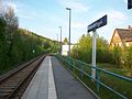
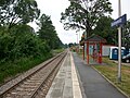
Lößnitz ob Bf ( 50 ° 37 ′ 29 ″ N, 12 ° 44 ′ 59 ″ E )
Initially opened as Lößnitz , the name was changed to Lößnitz Bahnhof in 1899 . From 1911 the station was officially named Lößnitz ob Bf . At that time, two platform tracks were used for passenger traffic, and there were also two side tracks. A reception building as well as a farm building, a goods shed and a combined head and side loading ramp were present on the high-rise buildings. In the station there was a siding to the local farming trade cooperative . It was last used in 1991.

Lößnitz ob Bf stop (2016)

Lößnitz ob Bf stop (2016)
Lößnitz ob Bf, former station building (2016)
Lößnitz ob Bf, former station building, street side (2016)
.JPG)
.JPG)
.JPG)
.JPG)
Lößnitz unt Bf ( 50 ° 36 ′ 40 ″ N, 12 ° 43 ′ 28 ″ E )
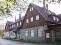
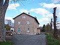
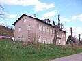
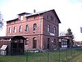
The station was opened in 1885 as Niederlößnitz stop for passenger traffic at route kilometers 46.25. Since Niederlößnitz and Lößnitz had petitioned for an opening to goods traffic in 1895, it was finally decided in 1898 to build a new station. In November 1899, this station, equipped with a reception building, farm building, goods shed and a head and side loading ramp, was opened at route kilometers 46.63. Since Niederlößnitz was incorporated into Lößnitz in 1898, the station was named Lößnitz stop since October 1898 . In 1911 the name was changed to Lößnitz unt Bf . Because of the steep incline of the station tracks, a guard track was installed in 1958. The reception building is the domicile of the model railway club "Bahnhof Lößnitz" eV

Lößnitz und Bf (2016)
Lößnitz unt Bf, reception building (2016)

Reception building (side view 2011)

Lößnitz und Bf (2016)

Lößnitz unt Bf, goods handling (2016)
.JPG)
.JPG)

.JPG)

Aue (Sachs) Erzgebirgsstadion ( 50 ° 35 ′ 48 ″ N, 12 ° 42 ′ 32 ″ E )
.JPG)
The Aue (Sachs) Erzgebirgsstadion stop in the immediate vicinity of the Erzgebirgsstadion was only created during the renovation. In spring 2005 the station, whose 80 m long platform lies in an inclined track curve, was opened.
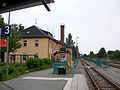
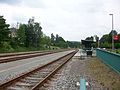
Aue (Sachs) ( 50 ° 35 ′ 30 ″ N, 12 ° 41 ′ 54 ″ E )
Since the CAAE was not allowed to use the existing facilities of the state railway, the railway company built its own facilities west of the state railway. The Chemnitz – Aue – Adorf line also crossed the Schwarzenberg – Zwickau line without any elevation. Due to the growing traffic, the station had to be expanded again and again, the absolute heyday came from 1946 through the bismuth mining and the associated station extensions. Even after the decline in mining, the station retained its importance as a local transport hub. The last major change took place from 2002 to 2004, when most of the facilities were dismantled. Due to the renovation in 2016, the platforms are at ground level, i.e. barrier-free . The access tunnel under the tracks was buried in parallel.

Aue (Sachs) station, still with the now demolished station building

Aue station after demolition of the reception building, view from Heidelsberg (2010)

Aue (Sachs) station with Aue-cell underpass and Erzgebirgsbahn train (2014)
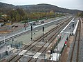
Aue (Sachs) station with redesigned entrance (2016)


_Unterf%C3%BChrung_Aue-Zelle.JPG)
_mit_neu_gestaltetem_Zugang_(3).jpg)
Auerhammer loading point ( 50 ° 34 ′ 50 ″ N, 12 ° 41 ′ 31 ″ E )
.jpg)
The gasworks of the city of Aue in Auerhammer , which was built at the end of the 19th century , also received a siding; due to public interest, the track system had been used as a loading point since August 1, 1900. After the Second World War, the station name was Aue Süd . On January 1, 1975 the loading point was closed and converted into a connecting railway. The corresponding bridge is still preserved at the former location.

Bockau (Erzgeb) Ost ( 50 ° 32 ′ 55 ″ N, 12 ° 40 ′ 13 ″ E )
The Bockau (Erzgeb) Ost stop was set up in the spring of 1954 for SDAG miners . At the stop, which was closed again in November 1954, there were no other buildings other than a platform.
Bockau (Erzgeb) ( 50 ° 32 ′ 31 ″ N, 12 ° 39 ′ 35 ″ E )
The Bockau (Erzgeb) train station was equipped with three continuous main tracks and a stump track. In addition to two platforms for passenger traffic, there was a goods shed, a wooden loading ramp and a short loading lane for goods traffic. The track systems were reduced as early as the 1950s, and the freight shed track was completely eliminated. A second demolition took place in the 1970s, and the station was now classified as an unoccupied stop with a junction. When the station was opened it was called Bockau and was renamed Bockau (Erzgeb) on May 15, 1933.

Bockau station, street view (2016)

Bockau station with Muldental cycle path (2016)
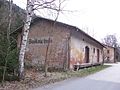
Annex building of Bockau train station (2016)
.JPG)
.JPG)
.JPG)
Blauenthal ( 50 ° 30 ′ 57 ″ N, 12 ° 37 ′ 34 ″ E )
The Blauenthal station initially consisted of four tracks, one of which was dismantled after the Second World War. When the line was interrupted by the construction of the dam in 1975, the importance of the station as the end point for passenger trains from Aue increased again, so the dismantled track was rebuilt. Initially, the station was still an independent office, later Blauenthal was subordinated to the Aue (Sachs) station.

Blauenthal station in 1992, still in operation

Blauenthal station after closure and track dismantling
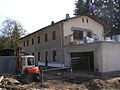
2011: The station building under construction

2013: Large new factory building on the railway site

Reception building with Muldental Cycle Path 2013


Wolf green ( 50 ° 31 ′ 16 ″ N, 12 ° 36 ′ 35 ″ E )

Initially an independent office, Wolfsgrün was subordinate to Bockau station from 1966, and in autumn 1968 the station was converted into a stop with a junction. With the division of the route in 1975, Wolfsgrün lost further importance, so the original three tracks were dismantled to two. A tank loading ramp built in the late 1980s for a military site in Schneeberg - Wolfgangmaßen was no longer used because of the fall of 1989/90. After the reception building was demolished in 2000, all track systems were removed in spring 2003.
Eibenstock unt Bf ( 50 ° 30 ′ 45 ″ N, 12 ° 34 ′ 56 ″ E )
.jpg)
At first the station was only referred to as Eibenstock station. Since the train station was far away from the town of Eibenstock in the Muldental, the line to Eibenstock above Bf was opened in 1905 and at the same time the train station was renamed Eibenstock und Bf. With the construction of the Eibenstock dam , the station was shut down and demolished on October 5, 1975. The station area is today in the reservoir of the Eibenstock dam.
Schönheide Ost ( 50 ° 30 ′ 15 ″ N, 12 ° 33 ′ 18 ″ E )


The station has had four different names so far, in detail these were:
- until January 31, 1892: Schönheide
- until May 20, 1910: Schönheider Hammer
- until 1950: Schönheiderhammer
- since 1950: Schönheide Ost
When the station opened, the station had three tracks. As early as 1878, the goods shed, which was too small, was relocated to Rautenkranz and replaced by a larger new building; the tracks have been expanded a bit. After the turn of the century, two more loading tracks were built due to the increased freight traffic.
At the end of the 1970s, the station area was completely rebuilt. The Zwickauer Mulde was relocated in a new canal south of the station, so that a bridge was omitted at the two station heads. The goods shed had to be demolished for the canal. Of the previously existing eight tracks, only five remained after the renovation.
The station also had a connection to the nearby ironworks, the later eponymous Schönheider Hammer . This connection, which was operated until the 1990s, has now been completely dismantled.
Schönheide Süd ( 50 ° 28 ′ 33 ″ N, 12 ° 30 ′ 51 ″ E )

The station Schönheide Süd (to 1950: Station Wilzschhaus ) is the lane change station for narrow-gauge railway Wilkau-Haßlau-Carl field . It is located in the Mulde valley without reference to the village of Schönheide, only the small, eponymous Schönheide district of Wilzschhaus is nearby. After the closure of the narrow-gauge railway, the narrow-gauge section of the station was dismantled in 1979. The standard gauge systems, on the other hand, were used until 1995 and were then spared from being dismantled.
Recently, the Förderverein Historische Westsächsische Eisenbahnen e. V. (FHWE) about a museum-friendly reconstruction of the entire system. In this context, part of the narrow-gauge tracks was also rebuilt. The normal-gauge section is the starting point for trolley trips on the “Wernesgrüner Eisenbahnexpress” to Hammerbrücke.
Diamond ring ( 50 ° 27 ′ 50 ″ N, 12 ° 29 ′ 36 ″ E )
Just three years after opening, the station was expanded by the State Railways in 1878, and the dismantled goods shed from Schönheide was also rebuilt here. In 1969 the station was downgraded to a stopping point and completely closed with the cessation of passenger traffic in 1982. Since the first German in space , Sigmund Jähn , came from the town, the reception building housed the “ German Space Exhibition ” museum until 2007 , which was then moved to a newly opened exhibition hall nearby. In 2018, the entrance building, which has been vacant for ten years, will be expanded into a guesthouse with a bistro, which is to be named "Rautenkranz Space Station". At present, the station is the stop for the motor trolleys of the “Wernesgrüner Eisenbahnexpress”.

Reception building of the Rautenkranz train station with Sigmund Jähn's MiG21-F13 at the old location (2007)
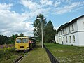
Rautenkranz station with the Wernesgrüner Eisenbahnexpress (2012)


Tannenbergsthal (Vogtl) ( 50 ° 27 ′ 0 ″ N, 12 ° 28 ′ 20 ″ E )
The station was opened as Jägersgrün station with three tracks. The locomotives took water here from the very beginning. In 1877 the station was extended for the first time by a track with a wooden loading ramp. With the downgrading of the section from Jägersgrün to Adorf to the branch line, the station was expanded to include a two-hour boiler house. After the incorporation of Jägersgrün , the station was renamed the Tannenbergsthal (Vogtl) station on May 15, 1935 . The boiler house was demolished in the 1950s.
On June 22, 1998, the station building and the water tower were damaged by a severe storm which also covered the locomotive shed of the former Falkenstein depot . The station building was then torn down. Today there are only two tracks left in the station. At present, the station is the stop for the motor trolleys of the “Wernesgrüner Eisenbahnexpress”.
Jägersgrün station around 1910, similar station buildings are also in Bockau (Erzgeb), Blauenthal, Wolfsgrün, Schönheide Ost and Rautenkranz

Tannenbergsthal (Vogtl) station with the Wernesgrüner rail express (2016)

Wernesgrüner Rail Express at Tannenbergsthal (Vogtl) station (2016)

.jpg)
.jpg)
Hammerbrücke ( 50 ° 26 ′ 6 ″ N, 12 ° 24 ′ 29 ″ E )
The small intermediate station Hammerbrücke was at route kilometers 87.7, one platform was enough for the modest tourist traffic. In freight traffic, a siding to a sawmill contributed significantly to the volume of traffic. Since the 1990s, Hammerbrücke has only had the continuous main track. At present, the station is the end point of the motor trolleys of the “Wernesgrüner Eisenbahnexpress”.

Hammerbrücke station, track view (2016)

Hammerbrücke station, street view (2016)

Hammerbrücke station, Wernesgrüner Eisenbahnexpress board (2016)
.jpg)
.jpg)
.jpg)
Muldenberg ( 50 ° 25 ′ 31 ″ N, 12 ° 23 ′ 50 ″ E )

With the construction of the Falkenstein – Muldenberg railway line , a separation station was built in Muldenberg . The station, opened in 1892, is located about two kilometers from the eponymous village of Muldenberg in the middle of the forest. Today the station still serves as a crossing station, the switch to Schönheide Ost has been expanded since 1997.
After the Muldenberg station had been canceled as a stop by the ZVV , the main platform and the passenger crossing were dismantled. The station can still be used for train crossings. There are plans at the municipal level to build a new, inexpensive platform in a different location.
Muldenberg Floßplatz ( 50 ° 24 ′ 58 ″ N, 12 ° 23 ′ 55 ″ E )
The Muldenberg Floßplatz stop in the center of Muldenberg was put into operation in November 2001. Trains only stop here when needed.
Muldenberg Floßplatz stop (2016)

Muldenberg Floßplatz stop, waiting hall (2016)
.jpg)
.jpg)
Schöneck (Vogtl) ( 50 ° 23 ′ 45 ″ N, 12 ° 20 ′ 37 ″ E )
The Schöneck (Vogtl) station was one of the larger intermediate stations with five tracks from the start. In addition to two platforms, a station building, a farm building, a goods shed and a timber loading ramp, there was also a siding to the station. A small locomotive had been stationed in Schöneck since the 1930s, and the vehicle - for which a separate small locomotive shed had been built - had to be handed over to the Eastern Front in 1942 for use in the war . The freight shed of the station, which was independent until 1989, was demolished at the end of the 1990s. Since 1997 there is only one continuous track and the station area has been partially built over with the B 283 .

Schöneck (Vogtl) station, direction Muldenberg (2016)

Schöneck (Vogtl) station, direction Zwotental (2016)
_(3).jpg)
_(1).jpg)
Schöneck (Vogtl) holiday park ( 50 ° 23 ′ 24 ″ N, 12 ° 20 ′ 50 ″ E )

The demand stop near the IFA holiday park was only set up in 2000.
Zwotental ( 50 ° 21 ′ 44 ″ N, 12 ° 21 ′ 49 ″ E )
Initially called Zwota , the station was renamed Zwota Bahnhof in 1902 and finally Zwotental in 1909 . Although the railway to Klingenthal branched off here, the station only became an important traffic junction with the opening of the Klingenthal – Untergraslitz border connection in 1886 and the Falkenstein – Muldenberg railway in 1892. Today the former Inselbahnhof still fulfills the branch function towards Klingenthal, the track systems were reduced to two tracks at the end of the 1990s.

Reception building of the Zwotental train station

Zwotental station (2016)

Zwotental station, reception building (2016)

.jpg)
.jpg)
Gunzen ( 50 ° 21 ′ 5 ″ N, 12 ° 19 ′ 59 ″ E )
.jpg)
The breakpoint was opened on November 1, 1908. The only structure at the stop is a wooden waiting hall.
Siebenbrunn ( 50 ° 18 ′ 30 ″ N, 12 ° 18 ′ 7 ″ E )

Since the city of Markneukirchen contributed financially to the construction of the railway, the station was initially called Markneukirchen, although it was in the area of the municipality of Siebenbrunn . Only after the opening of the branch line to Markneukirchen , which was integrated in the station and which was later extended to Erlbach , was the station name changed.
Today there is only the continuous main track in the station, which has been downgraded to the breakpoint.
Adorf stop ( 50 ° 18 ′ 59 ″ N, 12 ° 16 ′ 11 ″ E )
,_Standort_des_abgerissenen_Empfangsgeb%C3%A4udes_(1).jpg)
As in Chemnitz, the CAAE had its own train station in Adorf with the Adorf stop . Freight wagons could be exchanged with the state railway via a transfer track, travelers had to walk to the state railway station, which is about a kilometer away. With the nationalization of the CAAE, the freight trains were initially led directly to the state train station. After the passenger trains also ended at the state train station a year later, the existing systems were removed except for the station building. In autumn 2012 the reception building was also demolished.
Adorf (Vogtl) ( 50 ° 19 ′ 28 ″ N, 12 ° 15 ′ 38 ″ E )

The station had already been opened with the Voigtland State Railway in 1865. With the integration of the Chemnitz – Aue – Adorf line and the Asch – Adorf line, Adorf developed into a regional rail hub, and the trains on the Erlbach / Markneukirchen line also ended in Adorf.
In addition, Adorf was also important as a locomotive station and later as an independent railway depot . These systems are used today by the Vogtland Railway Association in Adorf .
Civil engineering
Dittersdorf Bridge ( 50 ° 37 ′ 4 ″ N, 12 ° 45 ′ 54 ″ E )
The only viaduct on the Chemnitz – Aue section is at route km 43.5. The stone arch bridge, 47.6 m long with four arches, is followed by a longer stretch of route secured by a large retaining wall. The bridge is located in the Lößnitz district of Dittersdorf .

Large railway viaduct in Dittersdorf (Lößnitz) with the Erzgebirge Railway (2)

Large railway viaduct in Dittersdorf (Lößnitz) (2016)

Small railway viaduct in Dittersdorf (Lößnitz) (2016)
_mit_Erzgebirgsbahn_(2).JPG)
_(9).JPG)
_(6).JPG)
Bockauer Tunnel ( 50 ° 33 ′ 24 ″ N, 12 ° 40 ′ 56 ″ E )

Construction of the Bockau Tunnel at kilometer 56.2 began on April 5, 1873. The 308 m long tunnel was blasted through the rock by around 300 workers, several workers were killed in accidents. The tunnel, which cost around 400,000 marks, was breached in March 1874. The tunnel, like the bridge abutments, was already prepared for double-track expansion.
Schönheider Tunnel ( 50 ° 30 ′ 20 ″ N, 12 ° 34 ′ 6 ″ E )
The 103 m long tunnel at route km 70.3, like the Bockau tunnel, had a sufficient tunnel profile for double-track expansion. Since the tunnel lies below the water level of the Eibenstock dam, some renovation work was carried out after the line was closed and the tunnel portals closed with grids.

A train of the Chemnitz – Aue – Adorfer Railway with a leader leaves the tunnel east of Schönheiderhammer, with the Zwickauer Mulde in the foreground.
Tunnel portal Schönheider Tunnel, portal under water of the Eibenstock dam (2018)


Locomotive use

The CAAE initially procured machines of the types H IIIT and H VII . After the nationalization, class IIIb locomotives were also used. Later both the types IV T (series 71.3) and V T (series 89.2) were in use. The freight trains were hauled with classes V (class 53.82) and V V (class 53.6-7).
The class XIV HT (class 75.5) will soon replace the weaker class IV T in passenger train service, and class XI HT (class 94.20-21) was used in freight train service quite early . Even before the First World War, machines of type XII H2 (series 38.2–3) were also put on the line.
From the 1930s, the 86 series took over some of the services, the series formed together with the 38.2–3, 71.3 (only until the 1940s), 75.5 and 94.20–21 series remained the defining locomotive types until the 1960s on the route. Since the maximum permissible meter load was too low, no machines of the class XIII H (class 58.4) could be used, only from the Second World War these locomotives drove together with other identical vehicles of the class 58.2-5 / 10-21 primarily the section of Karl -Marx-Stadt to Aue. The 58.30 series - the reconstructed variant of the 58.2–5 / 10–21 - was also used here.

In 1967, with the series V 60 , V 100 and V 180.2–4, mainline diesel locomotives were used for the first time; As a result, the majority of the series 38.2–3, 75.5 and 94.20–21 vehicles were soon pushed out of service by the diesel locomotives and taken out of service. In the mid-1970s, after the stationing of more diesel locomotives, most of the remaining steam locomotives of the classes 58.2–5 / 10–21, 58.30 and 86 became superfluous. The series 94.20-21 was no longer required since the shutdown of the steep Eibenstock line - where service was almost exclusively carried out with this series until the end.
Occasionally in the 1960s, steam locomotives of the series 50.0–31 and series 52.0–77 were already used on the lower section of the route ; the series 50.0–31 and 50.35–37 only came as planned in the 1980s due to the oil shortage on the lower section of the route for use. The traction change was completed in December 1987 , after which, until the 1990s, steam locomotives only ran on the line as part of scheduled steam events .
From the 1980s, the 120 and 130 series were also allowed to drive on the route. The 120 series, however, was not used as planned, and the 130 series was only used for individual services. From the beginning of the 1990s, the 219 series was used in the Chemnitz – Blauenthal section of the route, completely displacing the 228 series (the earlier V 180) by 1994.
Between 1966 and 1973, railcars of the VT 2.09 series were already running between Muldenberg and Klingenthal , which did not prove themselves due to their inadequate motorization. The Vogtlandbahn has been using RegioSprinter since 1997 . Passenger train traffic between Chemnitz and Aue was initially taken over in 1998 by vehicles of the 628/928 series , which were replaced by class 642 railcars by 2003 .

Railcar of the Erzgebirgsbahn ( class 642 ) in Chemnitz

Chemnitz central station, Erzgebirgsbahn to Aue (Sachs) (2016)
Railcar of the Vogtlandbahn in Muldenberg (2017)

_(2).jpg)
_und_Klingenthal_(5).jpg)
Aue – Wolfsgrün cycle path
The disused section between Aue and Wolfsgrün was expanded to a cycle path and opened on May 3, 2013. The 11 kilometer long path is paved throughout and passes a tunnel. It runs along the Zwickauer Mulde valley and has been part of the Mulderadweg since it opened . A partially re-routed cycle path along the Mulde from Schönheiderhammer to Wilzschhaus and on to Muldenhammer is being planned. It is intended to complement the existing cycle path between Aue and Blauenthal on the former railway line, which is to be continued as far as Schönheiderhammer. The former station building of the Schönheide Ost train station is to be expanded into a rest and service station on the Muldental cycle path. The application for approval of the modifications has already been submitted. The community of Schönheide supports the project.

Muldental-Bahnradweg in Bockau (2016)

Muldental-Bahnradweg in Bockau (2016)

Muldental-Bahnradweg near Wolfsgrün (2013)
.JPG)
.JPG)

.jpg&filetimestamp=20111019174713)
literature
- General
- Siegfried Bergelt: In the footsteps of the old West Saxony main line - the Chemnitz – Aue – Adorf railway line. Bildverlag Böttger, Witzschdorf 2004, ISBN 3-9808250-7-8 .
- Jürgen Viehweger: The Zwönitztalbahn Chemnitz – Aue. Verlag Jacobi, Fraureuth 2006, ISBN 3-937228-09-8 .
- Holger Drosdeck, Wilfried Rettig: The Aue – Adorf railway line and the narrow-gauge Wilzschtalbahn Schönheide Süd – Carlsfeld. Fraureuth 2009, ISBN 978-3-937228-00-6 .
- Wilfried Rettig: The railways in Vogtland - Volume 1: Development, main lines, vehicles, depot and buildings. EK-Verlag, Freiburg 2001, ISBN 3-88255-686-2 .
- Stefan Schneider: The Zwönitz station and its three railway lines. Self-published, Zwönitz 1996.
- To the history of origin
- Friedrich Constantin von Beust : The railway connection between Zwickau and the Upper Ore Mountains as a means against the decline of the iron industry , Verlag Engelhardt, Freiberg 1852 ( digitized version )
- Friedrich Constantin von Beust: The Upper Ore Mountains Railway , Engelhardt Verlag, Freiberg 1854 ( digital copy )
- Friedrich Constantin von Beust: The Upper Ore Mountains and the Railways , Engelhardt Verlag, Freiberg 1855 ( digitized version )
- Emil Roch: Memorandum on the construction of a railway from Aue in Saxony through Mulden- and Zwotenthal to Falkenau in Böhmen , printed by BG Teubner, Dresden 1857, 31 pages report in the Leipziger Zeitung
Web links
- Homepage of the Wernesgrüner Rail Express
- Friends of Historic Westsächsische Eisenbahnen eV
- Pictures of the abandoned Bockau tunnel
- Pictures of the flooded Schönheiderhammer tunnel
Individual evidence
- ^ Friedrich Constantin Freiherr von Beust : The Upper Erzgebirge Railway , published by JG Engelhardt, Freiberg 1854 digitized
- ^ Emil Roch: Memorandum on the construction of a railway from Aue in Saxony through Mulden- and Zwotenthal to Falkenau in Böhmen , printed by BG Teubner, Dresden 1857, 31 pages report in the Leipziger Zeitung
- ↑ Wilfried Rettig: The railways in Vogtland - Volume 1: Development, main lines, vehicles, depot and buildings. P. 85.
- ^ Wilfried Rettig: The railways in Vogtland - Volume 2 , EK-Verlag, Freiburg, 2002; ISBN 3-88255-687-0 , p. 68
- ↑ Erich Preuß , Reiner Preuß : Saxon State Railways . 1st edition. transpress Verlagsgesellschaft mbH, Berlin 1991, ISBN 3-344-70700-0 , p. 134 .
- ↑ a b Erich Preuß , Reiner Preuß : Saxon State Railways . 1st edition. transpress Verlagsgesellschaft mbH, Berlin 1991, ISBN 3-344-70700-0 , p. 294 and third cover page .
- ↑ Anke Heiser and Ralf Sudbrack: 25 years of drinking water from the Eibenstock dam - a constant challenge in: 15 years of state dam administration - colloquium on April 5, 2007, p. 19 [1]
- ^ Disused routes in Saxony. (XLSX; 16 KB) In: eba.bund.de. Federal Railway Office, September 11, 2017, accessed on April 16, 2018 .
- ↑ Decommissioning notice of the Federal Railway Authority of December 16, 2016 ( Memento of January 1, 2017 in the Internet Archive )
- ↑ Railway line saved. In: oveb.de. Förderverein Obervogtländische Eisenbahn (OVEB) eV, January 13, 2018, archived from the original on February 3, 2018 ; accessed on April 16, 2018 .
- ↑ Zwotental - Adorf route. (PDF; 255 kB) Regio Infra Service Sachsen GmbH , accessed on March 12, 2020 .
- ↑ Homepage of the Museumsbahn Schönheide eV ( Memento from August 24, 2017 in the Internet Archive )
- ↑ Friends of the Via Wilzschhaus e. V. ( Memento from August 22, 2014 in the Internet Archive )
- ^ Declaration on the Via Wilzschhaus tourism project. (PDF) Förderverein Via Wilzschhaus e. V. and Via Wilzschhaus GmbH, January 14, 2014, archived from the original on February 3, 2014 ; Retrieved January 19, 2014 .
- ↑ News on fhwe.de
- ^ Rail replacement service Chemnitz - Aue. (No longer available online.) Verkehrsverbund Mittelachsen , August 20, 2018, formerly in the original ; accessed on September 8, 2018 . ( Page no longer available , search in web archives )
- ↑ STRABAG commissioned with the 2nd expansion stage of the Chemnitz - Aue railway line. STRABAG AG, Cologne, August 19, 2019, accessed on April 18, 2020 .
- ↑ Chemnitz model: start delayed. In: Free Press. February 21, 2019, accessed March 12, 2019 .
- ↑ Level 2: Railway section. Current status. Central Saxony transport association , accessed on May 7, 2020 .
- ↑ Level 2: Railway section. Financing. Central Saxony transport association , accessed on May 7, 2020 .
- ↑ Jürgen Werner: Chemnitzer Model: What is changing in the south of the city. In: Free Press. October 26, 2018, accessed November 13, 2018 .
- ↑ Chemnitz model stage 2: Expansion of Chemnitz - Aue. (No longer available online.) Verkehrsverbund Central Saxony , formerly in the original ; Retrieved November 19, 2017 . ( Page no longer available , search in web archives )
- ↑ Kurt Kaiß, Matthias Hengst: Chemnitz railway junction - rail network of an industrial region. Salba-Verlag, Düsseldorf 1996, p. 112.
- ^ Rail replacement service Chemnitz - Aue. Central Saxony transport association , August 20, 2018, accessed on September 8, 2018 .
- ^ Jürgen Viehweger: The Zwönitztalbahn Chemnitz – Aue. P. 42.
- ↑ Plan drawing of the Chemnitz-Erfenschlag Ost stop
- ↑ Plan drawing of the new stop at Einsiedel Gymnasium
- ↑ Tracks in service facilities (as of July 1, 2008) ( Memento from June 2, 2016 in the Internet Archive ) (PDF; 277 kB)
- ^ History of the Einsiedeln train station and the stops
- ↑ Plan drawing of Einsiedel station
- ↑ Plan drawing of the future Chemnitz-Einsiedel August-Bebel-Platz stop
- ↑ Plan drawing of the future Chemnitz-Einsiedel brewery stop
- ↑ History of the Einsiedler Brewery
- ↑ Plan drawing of the Dittersdorf train station (near Chemnitz)
- ↑ a b Siegfried Bergelt: In the footsteps of the old West Saxony mainline - the Chemnitz – Aue – Adorf railway line. P.56.
- ^ Jürgen Viehweger: The Zwönitztalbahn Chemnitz – Aue. P. 60.
- ↑ Plan drawing of Meinersdorf train station (Erzgeb)
- ↑ Plan drawing of the future Thalheim (Erzgeb) Nord stop
- ↑ Plan drawing of the train station Thalheim (Erzgeb)
- ↑ The reception building of Dorfchemnitz before the demolition on www.sachsenschiene.net
- ↑ The Dorfchemnitz station with pictures of the demolished reception building on WWW.sachsenschiene.net
- ↑ Plan drawing of the Zwönitz train station
- ^ Jürgen Viehweger: The Zwönitztalbahn Chemnitz – Aue. P. 97.
- ^ Jürgen Viehweger: The Zwönitztalbahn Chemnitz – Aue. P. 154.
- ^ Website of the model railway club "Bahnhof Lößnitz" eV
- ↑ Reconstruction of the Auer train station , In: Freie Presse , Aue local edition, April 12, 2016.
- ↑ a b c d Siegfried Bergelt: In the footsteps of the old West Saxony main line - the Chemnitz – Aue – Adorf railway line. P. 57.
- ↑ Historical table sheet from Aue with the Auerhammer loading point
- ↑ Website of the Wernesgrüner Rail Express
- ↑ Article in the "Freie Presse" dated June 10, 2016, accessed on September 15, 2018
- ^ Website of the museum "German Space Exhibition"
- ↑ Article in the "Freie Presse" from July 28, 2018, accessed on September 15, 2018
- ^ Wilfried Rettig: Zwickau (Sachs) –Falkenstein (Vogtl) - yesterday and today of the ZF line. Verlacg Jacobi, Fraureuth 2007, p. 151.
- ^ Chemnitzer Verlag und Druck GmbH & Co. KG: Vogtlandbahn - Muldenberg loses a stop. In: Freiepresse.de. Retrieved October 19, 2016 .
- ^ Chemnitzer Verlag und Druck GmbH & Co. KG: Plans for an affordable platform. In: Freiepresse.de. Retrieved October 19, 2016 .
- ↑ Lothar Brill Webmaster: Route 6663: Railway tunnels and tunnel portals, information from Lothar Brill. Retrieved January 12, 2020 .
- ↑ Gunter Niehus: The cycle path from Aue to Wolfsgrün is finally ready. In: www.freipresse.de. May 3, 2013, accessed July 21, 2013 .
- ↑ Schönheider Wochenblatt No. 10/2015 of March 6, 2015, p. 1
- ↑ Schönheider Wochenblatt No. 49/2015 of December 4, 2015, p. 6