Eibenstock dam
| Eibenstock dam | |||||||||
|---|---|---|---|---|---|---|---|---|---|
|
|||||||||
|
|
|||||||||
| Coordinates | 50 ° 31 '24 " N , 12 ° 35' 21" E | ||||||||
| Data on the structure | |||||||||
| Construction time: | 1974-1987 | ||||||||
| Height above valley floor: | 57 m | ||||||||
| Height above foundation level : | 65.50 m | ||||||||
| Height of the structure crown: | 543.00 m above sea level NN | ||||||||
| Building volume: | 273,000 m³ | ||||||||
| Crown length: | 307.5 m | ||||||||
| Crown width: | 7.7 m | ||||||||
| Power plant output: | 1.7 MW | ||||||||
| Data on the reservoir | |||||||||
| Altitude (at congestion destination ) | 539.60 m | ||||||||
| Water surface | 3.7 km² | ||||||||
| Storage space | 74.65 million m³ | ||||||||
| Total storage space : | 82.9 million m³ | ||||||||
| Catchment area | 200 km² | ||||||||
| Design flood : | 206 m³ / s | ||||||||
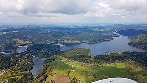
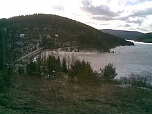
The Eibenstock dam is the largest dam in the Free State of Saxony , both in terms of its capacity and the height of the barrier structure . The water of the Zwickauer Mulde is dammed near Eibenstock east of Schönheiderhammer .
Geographical location
According to the natural map of Saxony , the Eibenstock dam is located in the microgeochore "Eibenstocker Talsperrengebiet", which belongs to the mesogeochore "Eibenstocker Bergrücken".
purpose
The dam serves to supply around 600,000 people with drinking water in the Chemnitz and Zwickau area , to protect against floods , to increase the low water level during periods of low rainfall and - to a lesser extent - to generate electricity from hydropower . With its dimensions, it is the second largest drinking water reservoir in the new federal states . The raw water runs from the dam in a 19.5 km long tunnel to the Burkersdorf waterworks.
Water quality
The water hardness is 1.75 degrees dH - soft starts at a value below 7 degrees dH. It ranks fifth among the Saxon dams. The annual mean depth of view is 450 centimeters. Swimming and recreational sports in and on the reservoir are not possible to protect the drinking water. Humic substances that arise in the moors and forests are carried along by the streams and rivers that strive towards the Zwickauer Mulde. This is especially true for those in the bog Big Kranichsee springing Wilzsch , one of the major tributaries of the trough. Under certain circumstances - with heavy precipitation and during the snowmelt - the humic content increases sharply. Since the 1990s, the concentration at Wilzsch has increased. The Saxon dam administration does not consider this pollution to be harmful to health and describes it as natural inputs that discolor the water. However, these could "lead to quality problems and have to be laboriously removed in the waterworks". The brown color of the water is also caused by the humic pollution. In order to stabilize the raw water quality at the Carlsfeld dam and to be able to absorb the peaks of humic matter in the water feeding the dam, the possibility of the polluted was created in 2010 through various hydraulic structures such as the creation of a fore basin, a dam, a diversion ditch and a pipeline To lead water through the dam. In the event of a high load of humic substances, the water flowing into the dam is routed via a distribution structure into a retention basin, from where it flows via the pipeline through the reservoir and the dam and back into the Wilzsch below the dam. According to the state dam administration, there was already a significant reduction in the amount of humic matter during the first damming after the construction of the new facilities. The 1,100-meter-long pipeline used to divert the humid-contaminated water is to be extended so that this water can flow as far as the Glashüttenbach and then flow over this creek and the Große Bockau to the Zwickauer Mulde and thus not pollute the Eibenstock dam. The planning approval decision of the Chemnitz regional directorate for this project is expected in 2016.
To ensure water quality, a tunnel almost five kilometers long was put into operation in 2000, through which the wastewater from Eibenstock, Schönheide and Stützengrün around the dam is led directly into the Wolfsgrün sewage treatment plant.
history
As early as 1890 there had been plans for a dam for the valley of the Zwickauer Mulde in the area of the present-day barrier, which were thickened in 1908. That is why in 1905 plans to expand the Neidhardtsthal paper mill were given up. In September 1915 it was announced in the Schönheider Wochenblatt by the Schwarzenberg authorities that preliminary work was being carried out for the dams on the Zwickauer Mulde near Eibenstock and on the Kleine Bockau near Sosa . The corridors Neidhardtsthal, Muldenhammer, Hundshübel, Eibenstock, Schönheide, Schönheiderhammer, Unterstützengrün, Sosa, Blauenthal and Wildenthal are affected by the work. In 1919, however, the Saxon government announced that the dam project would be abandoned. It was not until the growing population in Zwickau and Chemnitz in the 1960s that the reason to revisit the old plan considerations.
construction
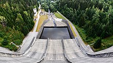
The dam of the Eibenstock dam is a straight gravity dam made of concrete. The dam was built from 1974 to 1984; Completion was in 1987, commissioning in 1982. The first partial damming took place in 1980. The dam has the pre- dam Schönheiderhammer and the four pre- basins Rähmerbach , Geidenbach, Weißbach, Rohrbach. The Filzbach (called Schönheider Bach and Dorfbach Schönheide in maps and official publications by the state of Saxony since the 2000s - with the water code 54115732 -), which formerly flowed into the Mulde in Schönheiderhammer, now flows directly into the water of the Schönheiderhammer pre-dam.
Protection of drinking water
Above the dam there was, during the construction of the dam, not only the pollution of the water from road traffic with polycyclic hydrocarbons, heavy metals and oils, but also the pollution from the nearby settlements of Eibenstock, Schönheide and Stützengrün with a large number of inhabitants (around 16,000 in 1990) and nonexistent to poorly functioning treatment of municipal wastewater. There was also the iron foundry and fiberboard factory in Schönheiderhammer, the artificial leather factory in Tannenbergsthal, the uranium ore processing plant in Tannenbergsthal-Schneckenstein, the specialist hospitals in Bad Reiboldsgrün , Carolagrün and Albertsberg and the LPG "Vorwärts" with heifers in Schönheide. These industrial and agricultural risks for the water from pathogens, water-endangering and health-endangering substances, nutrients (phosphorus, nitrogen and carbon compounds) required special precautions in the design of the dam. Although its catchment area with 81% forest, around 8% agricultural areas, 6% settlement and road areas and 4% water bodies is not unfavorable, a multi-barrier principle was nevertheless designed:
- Many successive stations of the water have to be designed in such a way that it reaches the tap with the best possible quality. This starts with the rehabilitation of the catchment area and the definition of a water protection area, goes through the construction of pre-dams and fore basins and the monitoring of the water in the inflows and the reservoirs to the management of the dam in accordance with the officially established water management plan and depending on the current situation.
A “water quality management and rehabilitation program” aimed to “shift the phosphorus pollution of the dam from the highly eutrophic to the mesotrophic range”. The wastewater - its purification and its discharge while bypassing the dam - was the focus of efforts. Since 1981 the wastewater from the fiberboard factory and foundry Schönheiderhammer and part of the communities Eibenstock and Schönheide has been piped past the dam with a pressure pipe. In 2000, a 4.9 km tunnel was drilled around the dam to discharge the Schönheide sewage. A pressure pipeline system of 1.15 km was installed from the Stützengrün pumping station and a combined pressure and pressure system from the Hundshübel pumping station. Freefall pipeline 4.50 km in length created. This wastewater is fed directly into the Wolfsgrün sewage treatment plant, which was built between 1988 and 1993. It has a capacity of 16,500 population equivalents. In addition to the closure of the fiberboard factory and the artificial leather factory, the renovation of the animal production facilities, the reduction of sulfur and fly ash pollution through other heating systems than before, the wastewater treatment and diversion in particular have led to a positive development in water quality. The removal of the wastewater from the Hundshübel area in particular had a positive effect: Although less than half a percent of the inflow volume, this water accounted for more than half of the phosphorus pollution. After the pumping station went into operation, it was reduced to almost zero in this inflow area.
Flood protection
The rise in water prices after the elimination of water price subsidies and the decline in industrial production from 1990 onwards led to a significant drop in water consumption and the demand for service water. The discharge of raw water from the reservoirs in the Central Ore Mountains, including the Eibenstock reservoir, fell by 40% from 1888 to 2000. This made it possible to reserve part of the storage space of the dam for flood protection. After the flood of August 2002 , the flood reserve capacity of the Eibenstock dam was increased by 4.22 million m³. During the flood in 2002, the dam lowered the peak discharge from 180 m³ / s to 55 m³ / s. The Eibenstock dam overflowed for the first time since its trial damming during commissioning. This happened again during the floods in 2013 .
Consequences of the dam
For the dam, the residents of Muldenhammer , whose former corridor is located in the flooding area of the dam, had to be relocated. Many of them moved into multi-family houses that were newly built in Eibenstock. Furthermore, the Chemnitz – Aue – Adorfer railway between Wolfsgrün and Schönheide Ost station in Schönheiderhammer was interrupted. The tunnel in this section of the route was flooded. When the water level is low, the former portals of the tunnel can still be seen. The line branching off from Eibenstock lower station to Eibenstock upper station also had to be shut down. This route was once known as the steep Eibenstock route , as it was the only standard gauge railway in Saxony that had to cope with a gradient of 1:20.
Tourist aspects
A marked hiking trail leads around the dam. You can see the reservoir from a vantage point above the dam. Views of the dammed water are possible from numerous places. The dam near Neidhardtsthal has been accessible to everyone since 2014. In August 2012 the artist Klaus Dauven created reverse graffiti on the entire dam wall with the title "Fish Empire". It shows two trout. In 2014, the state dam administration together with the state enterprise for geographic base information published a hiking map with paths and information about the Eibenstock dam, which can be downloaded from the dam administration's website.
literature
- Anke Heiser and Ralf Sudbrack: 25 years of drinking water from the Eibenstock dam - a constant challenge in: 15 years of the state dam administration - colloquium on April 5, 2007, pp. 19-26 Digitized of the proceedings
See also
Web links
- Eibenstock dam on www.talsperren.net
- Information about the dam from the Saxon state dam administration
- Article of the state dam administration : "Fish Empire" - a temporary work of art at the Eibenstock dam
Individual evidence
- ↑ Natural space map service of the Landschaftsforschungszentrum eV Dresden ( information )
- ↑ a b Anke Heiser and Ralf Sudbrack: 25 years of drinking water from the Eibenstock dam - a constant challenge in: 15 years of the state dam administration - colloquium on April 5, 2007, p. 19 [1]
- ↑ a b International Commission for the Protection of the Elbe: The Elbe and its catchment area - a geographic, hydrological and water management overview , Chapter 4.6 - The Mulde, n.d., published after 2002, p. 116 digitized version ( Memento des original from 6. May 2016 in the Internet Archive ) Info: The archive link was inserted automatically and has not yet been checked. Please check the original and archive link according to the instructions and then remove this notice.
- ^ Annual report of the Saxon state dam administration for 2005, p. 40
- ↑ a b c d e Press release of the State Dam Administration Saxony 57/2010 of December 9, 2010 [2] , accessed on October 4, 2015
- ^ Annual report of the Saxon state dam administration for 2005, p. 6
- ↑ Flyer of the Saxon state dam administration from August 2013 [3]
- ↑ Presentation of the construction company [ Archived copy ( memento of the original from October 4, 2015 in the Internet Archive ) Info: The archive link was inserted automatically and has not yet been checked. Please check the original and archive link according to the instructions and then remove this notice. ], accessed October 3, 2015
- ^ Annual report of the Saxon state dam administration for 2011, p. 7
- ↑ Mail information dated October 7, 2015 from the Zwickauer Mulde / Obere Weisse Elster plant of the Saxon state dam administration
- ^ Website of the Westerzgebirge waterworks , accessed on December 22, 2017
- ^ Hermann Heinz Wille: Erzgebirge , series Our beautiful homeland, Sachsenverlag Dresden 1962, p. 13
- ↑ Gerhard Ebisch: Old production sites of the wood pulp, cardboard and paper industry in the valleys of the Zwickauer Mulde, the Schwarzwassers and the Mittweida and their tributaries. Schwarzenberg 2001, p. 76.
- ↑ Schönheider Wochenblatt of September 14, 1915, p. 1.
- ↑ Gerhard Ebisch: Old production sites of the wood pulp, cardboard and paper industry in the valleys of the Zwickauer Mulde, the Schwarzwassers and the Mittweida and their tributaries. Schwarzenberg 2001, p. 77.
- ↑ Sächsisches Landesamt für Umwelt und Geologie (Ed.): Water quality report 2003. Biological findings of the water quality of Saxon rivers with water quality map , Dresden 2004, page 34 digitized , accessed on September 2, 2017
- ↑ Wasserhaushaltsportal Sachsen , accessed on September 2, 2017. Call up the map by clicking on "Gewässername" and "Dorfbach Schönheide 54115732"
- ↑ Anke Heiser and Ralf Sudbrack: 25 years of drinking water from the Eibenstock dam - a constant challenge in: 15 years of the state dam administration - colloquium on April 5, 2007, p. 20 [4]
- ↑ a b c d Anke Heiser and Ralf Sudbrack: 25 years of drinking water from the Eibenstock dam - a constant challenge in: 15 years of the state dam administration - colloquium on April 5, 2007, p. 21 [5]
- ↑ a b Internet site of the Westerzgebirge waterworks association archive link ( memento of the original from August 1, 2015 in the Internet archive ) Info: The archive link was automatically inserted and not yet checked. Please check the original and archive link according to the instructions and then remove this notice. , accessed November 2, 2015
- ↑ Anke Heiser and Ralf Sudbrack: 25 years of drinking water from the Eibenstock dam - a constant challenge in: 15 years of the state dam administration - colloquium on April 5, 2007, p. 22 [6]
- ↑ International Commission for the Protection of the Elbe: The Elbe and its catchment area - a geographical, hydrological and water management overview , Chapter 4.6 - The Mulde, no year, published after 2002, p. 117 digitized version ( Memento des original from May 6, 2016 in the Internet Archive ) Info: The archive link was inserted automatically and has not yet been checked. Please check the original and archive link according to the instructions and then remove this notice.
- ↑ Information and pictures about the tunnels on route 6663 on eisenbahn-tunnelportale.de by Lothar Brill
- ↑ Free press online edition , accessed on October 13, 2014
- ↑ a b website [7] , accessed on November 4, 2015
- ↑ Download page [8] , accessed on November 4, 2015


