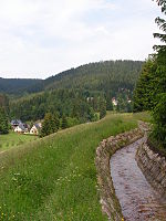
Great Bockau
| Great Bockau | ||
|
Great Bockau in Wildenthal |
||
| Data | ||
| Water code | DE : 54116 | |
| location | Saxony , Germany | |
| River system | Elbe | |
| Drain over | Zwickauer Mulde → Mulde → Elbe → North Sea | |
| source | At Johanngeorgenstadt 50 ° 25 '6 " N , 12 ° 39' 38" E |
|
| Source height | 930 m above sea level NN | |
| muzzle | At Blauenthal in the Zwickauer Mulde Coordinates: 50 ° 30 '55 " N , 12 ° 37' 32" E 50 ° 30 '55 " N , 12 ° 37' 32" E |
|
| Mouth height | approx. 466 m | |
| Height difference | approx. 464 m | |
| Bottom slope | approx. 33 ‰ | |
| length | 14 km | |
| Right tributaries | Little Bockau | |
The Große Bockau is an approximately 14 km long, right or southern tributary of the Zwickauer Mulde in the Western Ore Mountains in the Free State of Saxony . According to the natural map of Saxony, the “valley area of the Große Bockau” represents its own microgeochore and is part of the “Eibenstocker Bergrücken” mesogeochore.
Surname
The name is derived from the Old Sorbian Bukova for beech water . In the Saxon miles sheets of 1791 the river is still called "the great Buckau". There is the village of Bockau in the Ore Mountains to the northeast in another valley .


course
The Große Bockau rises south of the Buchkamm not far from the Czech border at an altitude of about 930 m above sea level. NN and flows in a northerly direction at the foot of the Auersberg past Oberwildenthal and Wildenthal . South of Zimmeracher, the Große Bockau takes on the Kleine Bockau coming from the right , before it flows into the Zwickauer Mulde at a height of about 480 m at the former Blauenthal train station .
history
The Große Bockau used to serve as a feeder to the Zwickauer Mulde for timber rafting. The hammer mill Wildenthal u. a. over the Grüner Graben built in 1555 . North of Oberwildenthal, water from the Große Bockau is diverted into a ditch (slope ditch) and led to the Sosa dam .
natural reserve
To the north of Wildenthal, to the left of the Große Bockau, is the Bockautal nature reserve and to the east is the Auersberg nature reserve . The entire valley of the Große Bockau with an area of 410 hectares is of European importance as a Natura 2000 area for nature conservation. This Natura 2000 area with the EU registration no. 5441-304 is called "Valley of the Great Bockau". The Saxon State Office for the Environment, Agriculture and Geology describes the need for protection as follows: “Valuable stands of mixed woodland and mixed beech forests as well as well-developed, species-rich mountain hay meadows, occurrence of highly endangered plant species such as arnica, wood lice and broad-leaved orchid, aspects of coherence”. The aim of the protection is the "preservation of a notched valley with predominantly wooded steep slopes with mixed beech forest, rocks, alluvial forest remnants and grassland areas on slopes that are characterized as species-rich mountain hay meadows."
additional
In the past, the name "Große Bockau" was also used for the tributary of the Flöha , known today as the "Schwarze Pockau" .
literature
- Hydrological manual. (PDF; 115 kB) Part 2 - Area Codes. Free State of Saxony - State Office for Environment and Geology, p. 12 , accessed on December 25, 2017 .
- The mining landscape of Schneeberg and Eibenstock (= values of the German homeland . Volume 11). 1st edition. Akademie Verlag, Berlin 1967, p. 143ff.
Web links
- Management plan for the Natura 2000 area Tal der Große Bockau
- " Die Große Buckau" on sheet 221 of the Meilen Blätter von Sachsen - Berlin copy from 1791 ( link to the digitized version in the Dresden State and University Library )
- Upper course of the Große Bockau in the equidistant rate 145 - Section Eibenstock - from 1875
- Upper course of the Große Bockau in the equidistant map 145 - Section Eibenstock - from 1897
- Große Bockau in the upper course in the topographic map 145 - Eibenstock - from 1904
Individual evidence
- ↑ Research map of the Landscape Research Center Dresden (LfZ) Link to the research map
- ↑ Sheet 221 of the Sächsische Meilenblätter (Berlin copy) from 1791 Link to the map in the Saxon State and University Library in Dresden
- ↑ Communications from the Statistical Association for the Kingdom of Saxony , 3rd delivery, articles on the topography and climatic conditions of the Kingdom of Saxony, from Christian Wilhelm Vogel, Leipzig 1833, p. 4 digitized version , accessed on April 29, 2015.
- ↑ a b Topographic map 1: 25,000, edition with hiking trails, sheet 15 Westerzgebirge Eibenstock, Johanngeorgenstadt, Sächsischer Staatsbetrieb Geobasisinformation und Vermessung, 2nd edition, Dresden 2010, ISBN 978-3-86170-717-2
- ↑ Area profile at the Federal Agency for Nature Conservation
- ↑ Description of protecting at Umwelt.Sachsen.de
- ↑ Ordinance of the Chemnitz Regional Directorate of January 31, 2011 to determine the area of community importance "Valley of the Great Bockau" (EU registration no. 5441-304, state no. 282) Description at Umwelt.Sachsen.de
- ↑ Karl von Weber (Ed.): Archive for the Saxon History , Volume 5, Bernhard Tauchnitz Verlag, Leipzig 1867, p. 250 digitized
