Auersberg
| Auersberg | ||
|---|---|---|
|
Observation tower |
||
| height | 1018.2 m above sea level NHN | |
| location | Free State of Saxony , Germany | |
| Mountains | Ore Mountains | |
| Dominance | 11.1 km → Blatenský vrch | |
| Notch height | 155 m ↓ swamp | |
| Coordinates | 50 ° 27 '22 " N , 12 ° 38' 49" E | |
|
|
||
| rock | granite | |
| particularities | Auersbergturm ( AT ), radar station | |
The Auersberg is 1018.2 m above sea level. NHN high mountain in the Ore Mountains . It is located in the Wildenthal district in the Saxon Erzgebirge district not far from the Czech border, southeast of Eibenstock and northwest of Johanngeorgenstadt .
Location and geology
Administratively, the Auersberg belongs to Wildenthal , which has been part of Eibenstock since 1994. To the north of the Auersberg lies the Sosa dam . There is a parking lot below the summit . On the ascent to Auersberg, the Johanngeorgenstadt district of Sauschwemme is crossed.
The main type of rock is medium-grain granite, in which tourmaline is included. The summit and part of the eastern slope are covered with andalusite mica in an 80-meter-thick clod. The granite also contains silver, tin and iron compounds that were already mined in the 16th century. At the height of mining activity there were up to 300 pits on the Auersberg. This included the Churhaus Sachsen treasure trove . In addition to the rocks mentioned, quartz and slate have also been detected, which occur in corridors on the summit.
Flora of the Auersberg
Mainly spruce and mountain ash grow up the slopes. Up to almost the summit they form a closed stand, which also owes its preservation to the fact that the forests have been under nature protection since the 1960s. The mountain is the location of the Auersberg beech .
History of the observation tower on the mountain
The Auersberg area was a preferred hunting ground for Saxon electors, who particularly hunted the red deer and capercaillie here.
Pastor Christian Gottlob Wild reported that around 1800 climbing the Auersberg was still considered an adventure. A wooden scaffolding with several sheds on the tower , which was built under Elector Johann Georg I of Saxony in the 17th century because of the view, survived only a few decades and was no longer present in 1791. From a report from 1726, however, it emerges that the wooden tower was not about the beautiful view, but about observation purposes in war runs
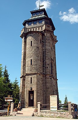
In 1860 the royal Saxon forest administration decided to bring granite stones up the mountain and took over the costs for the construction of a stone tower. The first observation tower in the Ore Mountains was inaugurated in 1860 and is therefore the oldest stone observation tower in the Ore Mountains. The tower was primarily used to monitor forest fires and as a station for the royal Saxon triangulation . In 1901 it was structurally thoroughly changed and raised to its current height of 18 m. In 1940 the viewing platform was finally given a wooden hood as protection.
An advertisement at the beginning of the 20th century stated: “The tower is open on Sundays and weekdays during travel time. Entry 20 pfennigs. Tower keeper Heidel in Wildenthal. “ This tower attracted many hikers who were provided with food and drinks, on weekdays by the Heidel family and on Sundays and holidays by the Schneidbach family. They carried up the food in a carrying basket. The remains were kept in an expanded and secret pit.
On November 9th, 1907, the press read: "Surrendered invitation to the consecration of the Auersberghaus, Sunday, November 10th, from 11 am onwards, combined with a concert." The opening of a mountain hotel was initiated by the Erzgebirgsverein . The first mountain innkeeper was Albert Heinz, followed by Max Teller from Johanngeorgenstadt and then Karl Kiesbauer.
On July 3, 1908, King Friedrich August III also returned to the lodging house on the Auersberg . from Saxony. "The view from the tower was splendid ... 'The wonderful forest!' He exclaimed when he saw the dark green sea in front of him," reported the announcement sheet on August 5, 1908. Just like him, many hikers and friends of home climbed in this time the mountain, so that the popularity was greater than expected.
The accommodation house was expanded as early as 1914, perhaps also because the king, who was staying in Wildenthal on August 24, 1912, was angry about the limited space available in the house.
During the Second World War there was a flak position on the mountain. To better protect the airspace observation post from adverse weather conditions, the tower's viewing platform was given a wooden sheathing.
Until the mid-1950s , the Ernst Schneller youth hostel was located in the accommodation house , which had been moved here from Johanngeorgenstadt after the end of the war due to uranium mining . In the 1960s, the Berggasthof was managed by the HO , which ran it as a mountain hotel.
From August 1983 the Ministry for State Security of the GDR had a radar station ( A tower ) built a little below the summit . The construction of the complex lasted until November 1985 and from then on was popularly referred to as the "Stasi Mosque" due to the dome. When, after German reunification, plans by the community of Wildenthal to convert it into a Stasi museum or a youth hostel failed, DFS ( German Air Traffic Control ) had the building converted in the 1990s and has been using it for the Auersberg SREM radar system ever since . Each of the six systems nationwide has a detection radius of around 145 NM ( nautical miles corresponds to 270 km).
In the years 1992–1994 the tower and the Auersberghaus were extensively and stylishly renovated by the Wildenthal community with extensive funding from the Free State of Saxony. The Berggasthof Auersberg , which has been owned by the mountain town of Eibenstock since the incorporation of Wildenthal, was briefly considered the highest hotel in Saxony until 1999 after the Fichtelberghaus was closed .
After the Berggasthof was sold to Peter Simmel by the city of Eibenstock in March 2018 , it has been open again since May 10, 2018.
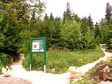
On July 13, 2011, the bilingual (German-Czech) educational trail “Bergwaldgarten Auersberg” was opened in the presence of the District Administrator of the Erzgebirge.
At the eastern foot of the mountain Auer who were up to a fire in the late 19th century Auersberger houses .
Paths to the summit
The shortest ascent from Wildenthal to the Auersberg summit is popularly called The Schlangenweg and leads up in six serpentines and along the toboggan run. Another option is to use the country road towards Oberwildenthal , then past the cemetery and over the central wing to the summit. The third option is called the zigzag path and leads from the center of the village to the Schlangenweg.
Only the parking lot below the summit can be reached by car.
literature
- Reinhart Heppner , Jörg Brückner , Helmut Schmidt: Saxon-Bohemian panoramic mountains of the western Ore Mountains in words and pictures with tourist information , Horb am Neckar, 2000, pp. 30–32.
- Auersberg. In: The mining landscape of Schneeberg and Eibenstock (= values of the German homeland . Volume 11). 1st edition. Akademie Verlag, Berlin 1967.
Web links
Individual evidence
- ↑ a b Map services of the Federal Agency for Nature Conservation ( information )
- ^ A b c Manfred Blechschmidt , Klaus Walther : Berglandmosaik. A book from the Erzgebirge. Greifenverlag zu Rudolstadt 1969, p. 44ff
- ↑ a b Manfred Blechschmidt, Klaus Walther: Silbernes Erzgebirge . Chemnitzer Verlag 1998; P. 130
- ^ Report from the judges and councilors to Eibenstock from August 10, 1726
- ^ Claudia Hinz: History of the Fichtelberghaus in text and images. Retrieved March 20, 2017 .


