
Sosa dam
| Sosa dam | |||||||||
|---|---|---|---|---|---|---|---|---|---|
 |
|||||||||
|
|||||||||
|
|||||||||
| Coordinates | 50 ° 29 '17 " N , 12 ° 38' 59" E | ||||||||
| Data on the structure | |||||||||
| Construction time: | 1949-1952 | ||||||||
| Height above valley floor: | 49.10 m | ||||||||
| Height above foundation level : |
58.40 m |
||||||||
| Building volume: | 101,000 m³ | ||||||||
| Crown length: | 200 m | ||||||||
| Crown width: | 4–4.5 m | ||||||||
| Radius of curvature : | 250 m | ||||||||
| Data on the reservoir | |||||||||
| Water surface | 39.3 ha | ||||||||
| Storage space | 5.94 million m³ | ||||||||
| Total storage space : | 6.33 million m³ | ||||||||
| Catchment area | 17.5 km² | ||||||||
| Design flood : | 0.4 million m³ | ||||||||

The Sosa dam is a dam in the Free State of Saxony . It serves the drinking water supply of the Western Ore Mountains and the flood protection .
The dam was built from 1949 to 1952 in Höllengrund south of Sosa , part of the town of Eibenstock since 2011 , in the Ore Mountains and finally put into operation in 1952. The dam is a curved gravity dam made of rubble masonry . It is the last dam of this type that was built in Germany. A mixed binder ( Sosa binder ) manufactured by Maxhütte Unterwellenborn with special properties in terms of strength, setting time and heat generation was used especially for its construction . The dammed body of water is the Kleine Bockau . In addition, water from the Großer Bockau is fed to the dam via the slope ditch west of the Auersberg from Oberwildenthal via Wildenthal .
Some technical details
Water withdrawal and storage volume
There are four tapping points in the dam to ensure good drinking water quality at all times, two bottom outlets and two tapping points at different heights. Until the mid-1970s, the tapping point was determined based on manual measurements, after which the system received an automatic control system for the raw water. In 2001, after the fall of the Wall , the newly established dam administration built a new ventilation system that can supply pure oxygen. The final water treatment takes place in the Sosa waterworks.
The reservoir has a volume of 5.94 million m³ and can hold up to 6.33 million m³ up to the overflow at the dam.
Water quality
More than 95 percent of the water comes from forest areas. One of the inflowing waters is the Neudecker Bach, which is fed from the Friedrichsheider high moor and thus supplies water rich in humin . All of the water is fed directly into the reservoir without a pre-lock . The water hardness is 1.0 degrees dH - soft starts at a value below 7 degrees dH - that is the second softest water in the Saxon dams after the Carlsfeld dam. The annual mean depth of view is 425 centimeters.
history
Already since 1908 there were plans for dams in the area of the Zwickauer Mulde and the Kleine Bockau. In September 1915 it was announced in the Schönheider Wochenblatt by the Schwarzenberg authorities that preliminary work was being carried out for the dams on the Zwickauer Mulde near Eibenstock and on the Kleine Bockau near Sosa. The corridors Neidhardtsthal, Muldenhammer, Hundshübel, Eibenstock, Schönheide, Schönheiderhammer, Unterstützengrün, Sosa, Blauenthal, Wildenthal would be affected by the work.

The dam plans before the First World War come from the city of Zwickau and have been the subject of consultations by the Saxon state parliament on several occasions. The war and the subsequent inflationary period initially prevented the continuation of these plans. In 1924, plans were resumed to build a series of dams in the Erzgebirge and Vogtland. But planning for Sosa was suspended.
After the Second World War , an improved drinking water supply became important again. In May 1949, what was then the state of Saxony in the Soviet Zone began implementing it on the basis of the existing, but now updated, construction plans. The GDR , founded in October 1949, proclaimed the construction of this water supply system as the FDJ's first central youth facility . After the laying of the foundation stone on June 17, 1950, the storage operation began on December 19, 1951 and the building was inaugurated by Prime Minister Otto Grotewohl . A total of 1,600 workers and engineers were involved in the construction. The final completion with the commissioning of all technical facilities then dragged on until 1952.
In view of the simple means used, the building is still considered technically remarkable. The realization as a youth object served the GDR propaganda in the following decades. The building was nicknamed the Dam of Peace , was mentioned in the song of the youth brigades ( "We provided water in Sosa ..." ) and highlighted on a stamp.
_1954,_MiNr_0431.jpg)
The traditional site of the Dam of Peace commemorated the construction of the dam from 1969 to 1989 . In the decades after commissioning, the technology was always kept up-to-date through maintenance and renewal. In 1972, measures were taken to improve aeration of the deep water in the reservoir. Between 1974 and 1976 the water catchment area of the reservoir was expanded by a new slope ditch.
Until the end of the GDR, the dam was state property; with the reunification of Germany , it became the property of the newly founded Free State of Saxony . The state government founded a dam administration for the administration of all dams now subordinate to it . This had the following renovations carried out between 2020 and 2008:
- Renovation of the bridge over the flood relief system,
- Installation of a small hydroelectric power plant with an output of 30 kilowatts,
- Renewal of the raw water extraction line,
- Repair of the slope trench.
In the period 2016–2018, the covering of the wall crown was renovated and a standard-compliant guardrail was installed. The renovation of the bottom outlet pipes was completed in 2018.
Flood protection and securing the drinking water supply
Since its completion, the dam has served both to protect against flooding and to provide a continuous supply of drinking water for the Aue-Schwarzenberg settlement area. It has a flood retention area with a volume of 0.397 million m³ . In particularly dry years, the level of the storage space can drop to three meters below the annual average.
On the occasion of the devastating floods in 1954, the GDR Post issued a special postage stamp with a picture of the Sosa Dam (design: Kurt Eigler; see above). The flood victims benefited from the surcharge of six pfennigs.
Recreational use
A public path has been running over the dam since September 2017. In view of the use of drinking water, swimming, fishing and recreational sports are not possible, but a six-kilometer circular hiking trail is signposted. From Sosa a road leads to a parking lot near the dam.

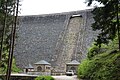
Reservoir with dam

The bottom of hell before the dam was built (1933)

FDJ meeting 1981 - 30 years of completion
The wall 60 years after its completion

Overflow


.jpg)
.jpg)
.jpg)
See also
- Cranzahl Dam ( Dam of Friendship )
- List of dams in Germany
- List of bodies of water in Saxony
literature
- Helmut Hauptmann : The Secret of Sosa , Berlin 1950, Gutenberg Book Guild
- Leo Binder: Unrest in Sosa , Roman, Verlag der Nation , Berlin undated (1952)
- Rainer Thiel: The reservoir under the Auersberg . Trafo-Verlag Weist, Berlin 2002, ISBN 3-89626-390-0
- Christian Wishes (Ed.): Were we heroes !? Sosa builders remember. Berlin, 2002
- Walter Kube: My Adventure Sosa | MDR.DE
- Sosa Dam of Peace. In: The mining landscape of Schneeberg and Eibenstock (= values of the German homeland . Volume 11). 1st edition. Akademie Verlag, Berlin 1967, pp. 145–146.
Movie
- Ulrich Liebeskind: Blue Devils in Hell's Ground - The builders of the Sosa Dam . Documentation from the series Der Osten - Discover where you live . MDR , 2012.
Fine arts and photography
- Herbert Riedel: Volksbau Sosa , three pictures (oil), 1950. German Historical Museum (DHM) Berlin, Kg 70 / 16-18.
- Walter Görgner: Volksbau Sosa (oil), 1950, construction of the Sosa (oil) dam , 1951. DHM Berlin, Kg 90/193 and Kg 66/2.
- Albert Herold : Sosa-Cranzahl series / Volksbau Sosa (linocut), 1951. SLUB / Deutsche Fotothek .
- Richard Meier and family ( Schnitzer ): Model of the construction of the Sosa (Heimatberg) dam , 1951. SLUB / Deutsche Fotothek. A replica of his son Kurt can be seen in the Saxon-Bohemian Ore Mountains Museum in Marienberg .
- Erich Höhne , Erich Pohl : Photos of the construction of the Sosa dam (over 1000), 1949-1952. SLUB / German Photo Library.
Web links
Individual evidence
- ↑ a b c d e f Information boards at the crown of the dam, as seen in October 2019.
- ↑ Hans Dehnert: Locks and lifts . Springer-Verlag, Berlin Heidelberg 1954, ISBN 978-3-540-01807-0 , p. 221 .
- ^ Annual report of the Saxon state dam administration for 2005, p. 40.
- ^ Hermann Heinz Wille : Erzgebirge , series Our beautiful homeland , Sachsenverlag Dresden 1962, p. 13.
- ↑ Schönheider Wochenblatt , September 14, 1915, page 1.
- ^ Digitized: Communications on the negotiations of the Ordinary Parliament in the Kingdom of Saxony , 1st Chamber on April 4, 1916 , p. 440.
- ^ The mining landscape of Schneeberg and Eibenstock (= values of the German homeland . Volume 11). . Edition. Akademie Verlag, Berlin 1967, p. 145.
- ↑ Contents of the DEFA eyewitness from 1951, point 3: Sosa dam put into operation , accessed on December 8, 2018.
- ↑ Hans Reinecke (photo): Information board Volksbau Sosa. SLUB / Deutsche Fotothek, 1983, accessed on May 14, 2020 .
- ↑ Press release of the state dam administration dated March 21, 2016, accessed on October 10, 2017.
- ^ Martin Starker (Dresden): Communication. Tractabel Hydroprojekt GmbH Weimar, September 17, 2018, accessed on September 9, 2019 .
- ↑ a b Press release from the state dam administration dated August 24, 2017, accessed on October 10, 2017.
- ↑ Photo of the water level on October 11, 2019: 635.50; maximum 639.00.
- ^ Albert Herold: Sosa-Cranzahl (linocuts). SLUB / Deutsche Fotothek, accessed on September 17, 2019 .
- ↑ Erich Höhne, Erich Pohl: Model of the construction of the Sosa dam, Richard Meier and family (photos). SLUB / Deutsche Fotothek, accessed on September 17, 2019 .
- ↑ Erich Höhne, Erich Pohl: Construction of the Sosa dam (photos). SLUB / Deutsche Fotothek, accessed on September 17, 2019 .