
Neidhardtsthal
|
Neidhardtsthal
City of Eibenstock
Coordinates: 50 ° 31 ′ 50 ″ N , 12 ° 36 ′ 20 ″ E
|
|
|---|---|
| Height : | 500 m above sea level NN |
| Residents : | 48 (May 9, 2011) |
| Incorporation : | January 1, 1994 |
| Postal code : | 08309 |
| Area code : | 037752 |
Neidhardtsthal is a district of the town of Eibenstock in the Erzgebirge district .
geography
Neidhardtsthal is located in the western Ore Mountains in the valley of the Zwickauer Mulde at an altitude of 500 m above sea level on the road between Hundshübel and Wolfsgrün directly below the dam of the Eibenstock dam . According to the natural map of Saxony , the village lies in the mesogeochore "Eibenstocker Bergrücken" and belongs to the microgeochore "Blauenthaler Mulde-Tal".
- Neighboring places
| Hundshübel | Burkhardtsgrün | Albernau |
.svg)
|
Wolf green | |
| Eibenstock | Sosa |
The Eibenstock dam is located between Neidhardtsthal and Hundshübel.
history
Neidhardtsthal emerged from a hammer mill that has been documented since 1566 , which was also known as the sulfur smelter, because the roasting process of pyrite-rich ores produced sulfur dioxide and sulfuric acid was produced from it on the spot.
August Schumann names 1819 in the State Lexicon for the Eisenhammer Neidhardtsthal among others:
- It consists of 1 Hohofen, 2 stick fires, 2 tin fires, 1 tin house and 1 Zainhammer, with 20 houses and 140 inhabitants.
Steel has been made at this plant since 1766.
A mine that still existed in 1846 was called the Bornkinnel-Maaßen-Zeche .
The independent municipality of Neidhardtsthal had 72 inhabitants at the 1939 census. It was dissolved on October 1, 1939 and most of it was added to the community of Blauenthal , only a small part went to Hundshübel .
Until the construction of the Eibenstock dam, Neidhardtsthal had a railway connection via the nearby Wolfsgrün station to the Chemnitz – Aue – Adorf line . The last trip took place in October 1975.
During the GDR era there was an LPG holiday home in Neidhardtsthal and the company holiday home of the VEB (K) water management of the city of Dresden.
As a district of the community of Blauenthal, Neidhardtsthal was incorporated into the town of Eibenstock on January 1, 1994 .
Development of the population
|
|
Location logo
The Eibenstock districts of Blauenthal , Wolfsgrün and Neidhardtsthal have had a common local logo since 2012 . The elements of water, hammer mills, hydropower and mining reflect the historical and current events of the places.
The logo is divided into two parts. The upper part is kept in green. Three black hammers on the right symbolize the hammer mansions of the three districts. The water wheel on the left symbolizes the water power, which z. B. at the dam of the Eibenstock dam in Neidhardtsthal is still used today. The lower blue field is separated from the upper field in a wave shape. This symbolizes the Zwickauer Mulde , which flows through all three districts. In the blue field there are mallets and irons , symbolic of the mining industry in the region.
traffic
Car traffic
Neidhardtsthal can be reached via a road that connects the federal highways 169 (Schneeberg - Plauen) and 283 (Aue - Klingenthal - Markneukirchen) (junction in Wolfsgrün or in Hundshübel).
Hiking trails
Lead through and past Neidhardtsthal
- Long-distance hiking trail Eisenach-Budapest (from Hundshübel and on to Filzteich and Schneeberg)
- Long-distance hiking trail Erzgebirge - Vogtland (on the same route)
- Long-distance hiking trail valley path of the Zwickauer Mulde (from Eibenstock and on to Albernau and Aue)
- Drei-Talsperren-Wanderweg (Carlsfelder Talsperre - Eibenstock - Wolfsgrün - Blauenthal - Sosa - Talsperre Sosa).
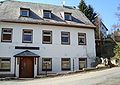
photos

Hammerherrenhaus

Portal at the Hammerherrenhaus

Keystone of the portal
Former Gasthof zum Eisenhammer (demolished in 2012)


literature
- Siegfried Sieber : History of Neidhardtsthal. In: Glückauf, Kultur- und Heimatblätter der Kreis Aue and Schneeberg 4 (1957) 9, pp. 171–174
- Neidhardtsthal. In: The mining landscape of Schneeberg and Eibenstock (= values of the German homeland . Volume 11). 1st edition. Akademie Verlag, Berlin 1967, pp. 111–113.
Web links
- Neidhardtsthal in the Digital Historical Directory of Saxony
Individual evidence
- ↑ Small-scale municipality sheet for Eibenstock, city. (PDF; 0.23 MB) State Statistical Office of the Free State of Saxony , September 2014, accessed on January 28, 2015 .
- ↑ Natural space map service of the Landschaftsforschungszentrum eV Dresden ( information )
- ↑ Website of the Saxon dam administration
- ↑ a b Geographisch-Kartographisches Institut Meyer (Ed., Head Adolf Hanle): Erzgebirge , in: Meyers Naturführer, Meyers Lexikonverlag Mannheim, Leipzig, Vienna, Zurich 1992, ISBN 3-411-07151-6
- ↑ Neidhardtsthal, Neidhardtsthaler or Schwefelhüttenhammer . In: August Schumann : Complete State, Post and Newspaper Lexicon of Saxony. 6th volume. Schumann, Zwickau 1819, p. 802.
- ^ Manfred Blechschmidt : Christmas customs in the Erzgebirge , Altis-Verlag, Friedrichsthal 2010, p. 75, ISBN 978-3-910195-60-8
- ↑ Area changes from January 1, 1994 to December 31, 1994 (PDF; 64 kB) State Statistical Office of the Free State of Saxony , p. 1 , accessed on December 31, 2012 .
- ↑ a b c d e f g Siegfried Sieber / Martin Leistner: The mining landscape of Schneeberg and Eibenstock. Values of the German homeland. Volume 11 , Berlin 1967, page 181
- ^ State enterprise geographic base information and surveying Saxony: Topographic map 1: 25,000, edition with hiking trails , sheet 15, 2nd edition, Dresden 2010, ISBN 978-3-86170-717-2

Blauenthal | Carlsfeld (with sheet metal hammer , Neues Wiesenhaus and Wilzschmühle ) | Eibenstock | Neidhardtsthal | Oberwildenthal | Sosa | Weitersglashütte | Wildenthal | Wolf green