
Burkhardtsdorf
| coat of arms | Germany map | |
|---|---|---|

|
Coordinates: 50 ° 44 ' N , 12 ° 56' E |
|
| Basic data | ||
| State : | Saxony | |
| County : | Erzgebirgskreis | |
| Management Community : | Burkhardtsdorf | |
| Height : | 400 m above sea level NHN | |
| Area : | 21.22 km 2 | |
| Residents: | 6118 (Dec. 31, 2019) | |
| Population density : | 288 inhabitants per km 2 | |
| Postal code : | 09235 | |
| Primaries : | 03721, 037209 | |
| License plate : | ERZ, ANA, ASZ, AU, MAB, MEK, STL, SZB, ZP | |
| Community key : | 14 5 21 120 | |
| Community structure: | 4 districts | |
| Address of the municipal administration: |
Am Markt 8 09235 Burkhardtsdorf |
|
| Website : | ||
| Mayor : | Jörg Spiller | |
| Location of the municipality of Burkhardtsdorf in the Erzgebirgskreis | ||
  |
||

Burkhardtsdorf is a municipality in the north of the Erzgebirgskreis in Saxony . It is a fulfilling community of the Burkhardtsdorf administrative community , of which it has been a member since March 21, 2008.
Geography and traffic
Burkhardtsdorf is located 12 km south of Chemnitz and 12 km east of the city of Stollberg / Erzgeb. on the northern edge of the Ore Mountains in the Zwönitztal . The heights in the municipality reach almost 600 meters. In the village, the B 95 crosses the B 180 . The Chemnitz – Aue railway line also runs through the community. The A 4 can be reached via Chemnitz and the A 72 via Stollberg.

Districts
- Burkhardtsdorf
- Eibenberg with Neu-Eibenberg
- Kemtau
- Meinersdorf
history


Burkhardtsdorf district
middle Ages
The settlement of the place probably took place in the middle of the 12th century by Main Franconian settlers on behalf of the Emperor Friedrich Barbarossa . The construction of the place in half of the Zwönitztal took place as a forest hoof village with pseudo-desolation. Basically all settlements took place on the sliding slopes of the Zwönitz. The steep and stony impact slopes remained forest as before. For safety reasons, the dwellings were laid out in a row and outside the flood-prone zone, each settler could still call and hear his neighbor. Even if the impact slopes were not built on, they were heaped up and assigned to the farmers, it was the "desert goods" on the impact slopes. Pseudo-desolation, because the term desolation presupposes that the area was built up and overgrown again due to any circumstances, but this was not the case with the Burkhardtsdorf "desolate goods".
The name Burkhardtsdorf originated when the place for the Chemnitz Benedictine monastery “St. Marien “ belonged. Until the Reformation, Burkhardtsdorf had to pay tribute to the Chemnitz monastery, as did the neighboring towns of Adorf and Klaffenbach .
The "Abte Burchardt" is named in two documents from 1216 and 1218: King Friedrich II, as a secular lord, takes the Kempnitz monastery under his protection in a document from 1216, confirms all rights and freedoms to Abbot Burchard and his successors. Likewise, the church makes a corresponding declaration in a document from 1218: Pope Honorius III. takes the abbot Burkhard and the Camnitz monastery under his protection.
These two documents allow the conclusion that the 4th abbot of the mountain monastery St. Marien zu Chemnitz, Burkhard, should be honored as a patron and sponsor of the place by naming the new settlement after him.
The spelling of the name has changed several times over the years. In 1331 "Burckerstorff", 1368 "Burckarstorff", 1408 "Burkirsdorff", 1427 "Burgkerstorf", 1475 "Burgkerhrsdorff", 1495 "Borckerßdorff", 1555 "Borkersdorff" and 1624 "Burcartsdorff". A uniform spelling "Burkhardtsdorf", which is still valid today, was established in 1891 by a resolution of the Royal Ministry of the Interior.
The first documentary mention of the place "Burckerstorff" was previously for the year 1331 in a document from the Dresden main state archive . This documented that Burkhardtsdorf was the only village allowed to brew its own beer at that time, while the other monastery villages had to tap Chemnitz beer.
The church of "Borckersdorff" is already mentioned in the Meißner diocese register from 1346. The church building is said to have been dilapidated as early as 1600. Funds for a new building came from the elector, from the Neukirchen estate and from the community and its craftsmen. However, there were adversities, such as a flood in 1628, which washed away almost all of the timber stored at the Ahnermühle. The plague and the turmoil of the Thirty Years' War also prevented a new building in the near future. It was not until 1695 that the church was rebuilt and consecrated. In 1749 the shingle roof was replaced by a slate roof. In 1839 the church was completely renovated. On February 14, 1945, the Burkhardtsdorf Church fell victim to an attack by American bombs. It was not rebuilt. Today's Burkhardtsdorf Church is the mourning hall that was converted by master builder Uhlig. It was consecrated as an emergency church on February 15, 1948. The ruins of the old church have been cleared and are now used for open-air worship services in the summer months. Ä.
Early modern age
For the year 1501 there was a Turkish tax register for Burkhardtsdorf , which can be viewed as the first register of residents. Some of the names still exist in the village today.
After the secularization and the dissolution of the Chemnitz monastery in 1543 the three monastery villages Burkhardtsdorf, Klaffenbach and Neukirchen were sold by Duke Moritz von Sachsen to the Annaberg citizen Wolf Hünerkopf. The Neukirchen estate was created. When Hünerkopf died in 1570, the Saxon Elector August bought the Neukirchen property from Hünerkopf's heirs and assigned them to the Chemnitz office. After several changes of ownership, the Neukirchen estate finally came into the possession of Dietrich von Taube in 1615. The von Taube family ruled the Herrengut and Schloss Neukirchen for over 200 years and thus also ruled Burkhardtsdorf. The rulership of Neukirchen supervised the community through the liege judges . That is why there was a feudal court in Burkhardtsdorf.
From 1560 court books were kept for Burkhardtsdorf , the oldest church book dates from 1605.
For the estate village Burckersdorff (Burkhardtsdorf) a market fairness is certified for 1568 . Market fairness included the manufacture and sale of linen fabrics at annual markets in Burckersdorff. In 1674, however, market justice for the cloth trade passed to Neukirchen. In 1868 or 1869 Neukirchen sold the market rights back to Burkhardtsdorf. Since then there have been fairs twice a year, once in spring and once in autumn. Each of these markets started at 8 a.m. on Monday and ends at 9 p.m. on Tuesday of the next week. These fairs can be traced back to Burkhardtsdorf until around 1948, with interruptions due to the wars.
During the Thirty Years' War the place was spared from war even in the first years. However, during the war there were tragic events such as the red dysentery , the plague and heated fevers as well as storms and floods, which caused the deaths to rise rapidly. Of the 41 farm estates and 5 garden foods, 40 are said to have been uncultivated for many years. A state parliament resolution of 1646, according to which everyone who takes over a desolate property, is exempt from land tax for six years , was intended to promote reconstruction.
Around 1570 was on the so-called stable plans of Georg von Öder the Elder. J. Burkhardtsdorf applied for the first time. Further representations followed, for example on a Ur-Öder sheet by Balthasar Zimmermann around 1620 and after 1790 on the “Sächsische Meilenblatt”, Berlin edition, sheet 201.
In 1696 the Leipzig-Chemnitz-Annaberg postal route was established. This initially led via Einsiedel , Gelenau and Herold . From 1712 onwards, numerous new postal rates were set, including that from Chemnitz via Burkhardtsdorf to Annaberg . In 1721, Adam Friedrich Zürner carried out a cartographic survey on behalf of the Elector of Saxony. In connection with this, post mile pillars were set up. In Burkhardtsdorf there was a full-mile column, the remains of which can still be seen in the book printing museum. A replica stands across from the pharmacy today.
19th century
In 1785 a fire insurance register was drawn up. In addition to the church and feudal court, 59 farms and 123 cottagers are named. In 1839 there was a new draft of the fire insurance register for Burkhardtsdorf. The fire register numbers assigned here for the properties still corresponded to the location list numbers valid until the middle of the 20th century . The actual confirmed cadastre has unfortunately not yet been found in any archive.
After replacement of the feudal manor and adoption of the Saxon State Municipal Code on November 11, 1838 were from 1,839 community leaders selected. Burkhardtsdorf had about 1800 inhabitants at that time. The first community council was August Knobloch from 1839 to 1844.
In 1875 the Chemnitz – Aue railway was put into operation. Burkhardtsdorf also received a train station. In connection with the railway construction, the Poststrasse to Annaberg was also raised. The Zwönitztal was now crossed over a bridge. In 1892/93 the construction of the Zwönitztalstrasse from Burkhardtsdorf to Dittersdorf, today's B 180.
In 1895 Burkhardtsdorf was connected to the telephone network. In 1900 the place received a post office building at Untere Hauptstrasse 31. In 1904 the power station was built on Alte Poststrasse.
20th century
In 1908 the construction of the outdoor pool began by locked textile workers and members of the naturopathic association. In 1993 the old facilities of the outdoor pool were torn down and a new contemporary outdoor pool was built.
In 1911 the last horse mail drove through Burkhardtsdorf. The old feudal court was demolished and a new town hall was built at this point, which was consecrated on December 28, 1911. It still serves as the seat of the municipal administration today.
In April 1913, street names were introduced in Burkhardtsdorf on the basis of a resolution by the local council.
In 1926 the local water pipeline was built, followed in 1930 by the construction of an elevated tank on the Niclasberg.
In 1927 the place got its own cinema, where there was regular cinema operation until the mid-1990s. After that it was occasionally used by clubs and is empty today.
In 1929 the municipality's own bath tub was inaugurated. It contained 19 baths, 4 shower baths, therapeutic baths of all kinds, a school shower bath and a public washing facility. A lot of repairs were necessary around 1960. By creating their own bathrooms in the households, the demand decreased noticeably and the operation was stopped in the 1970s.
Burkhardtsdorf was a pure farming village when it was founded. But line weaving began at an early stage, so in 1545 there were 11 linen weavers, 9 tailors, 6 blacksmiths, 5 wheelwright, 4 cooper, 4 cloth shearers and 2 shoemakers in addition to the farmers. In 1747 the first Burkhardtsdorf stocking maker Johann Christian Köhler is mentioned. In the 1830s, some Burkhardtdorfer mills were converted into cotton mills . As quickly as the cotton mills came into being, so quickly did their decline come, since the cotton was no longer supplied from America. As a result, stocking knitting gained a lot of momentum, so that in 1835 there were already 132 stocking knitters with 230 knitting chairs. In 1873, Adolf Hofmann used the first steam engine to manufacture socks. More stocking factories followed. Up until around 1927 there were 43 stocking factories in Burkhardtsdorf and, connected to them, six knitting needle factories.
After the Second World War, new branches of industry emerged, primarily the chemical industry through Schüngel-Chemie KG, later VEB Schaum-Chemie, Recticel and Eurofoam. Branches of the Karl-Marx-Stadt accounting machine plant also settled in the village. The hosiery industry came to a complete standstill in the 1980s.
Health care can be traced back to 1580. At that time there was a bathing room in the parish and an Andreas Bauer who called himself "Devoted body and sore Artzney". Other bathers are known until 1790. In 1865 there was an infirmary in the village at Chemnitzer Str. 2. From 1909 there were community nurses and from 1910 dentists were verifiable. In 1846 a pharmacy was opened, which is still in this place today. In 1956 the first nursing home was set up in the former vocational school and in 1958 an after-work home in the former villa of the stump manufacturer Pfau. From 1959 to 1991 there was a rural outpatient clinic in Burkhardtsdorf. After the political change there is a practice for general medicine and a dental facility. In 2001 the AWO senior center was built on Canzlerstrasse.
In old documents there was already talk of a schoolmaster and organist in 1582, and very early on the town had a small school next to the church. Teachers in this sense were mostly linen weavers or craftsmen under the supervision of the pastor. On May 9, 1839, the school was inaugurated in Niederdorf at Eibenberger Straße 11. On June 4, 1860, another school in Oberdorf, Kirchsteig 7, was added. In 1879/1880 the old, dilapidated and much too small church school was torn down and a new building was built in the same place, later called the "old school". Since July 24, 1949, it has been called the “Kurt Richter School”, named after the mayor Kurt Richter, who made it possible to rebuild this school, which was destroyed in the bombing on February 14, 1945, during the most severe times of need.
On August 14, 1916, another new school building was handed over, called the "New School". Only after the founding of the GDR did it receive its current name "Lessing School" on October 28, 1949, named after the poet Gotthold Ephraim Lessing. (This is not to be confused with Lessingstrasse. It was named after an ancestor of the poet who was pastor in Burkhardtsdorf in the 16th century.) Both schools are run by the Ecumenical School Association Burkhardtsdorf eV, founded in 2003. In April 2012, construction began on a completely new elementary school in the large municipality of Burkhardtsdorf. The topping-out ceremony was celebrated in October 2012 and the first children moved in at the start of school in 2013.
In the middle of the 19th century a lively club life began in Burkhardtsdorf. From 1839 there was the reading club, in 1842 the Burkhardtsdorf I singing and music club, 1846 the Spinnerkasse, 1849 the women's club, 1859 the military club, 1863 an agricultural club as well as several singing and music clubs, 1865 a gymnastics and sports club, and 1868 a privileged shooting society , In 1871 the savings and advance payment association, from which the savings bank later emerged. Even today, numerous clubs are still active in Burkhardtsdorf, such as the Bulldogfreunde Erzgebirge eV, the Burkhardtsdorfer Carnevals Committee eV, several garden clubs, sports clubs, the Erzgebirgszweigverein, church associations, the people's solidarity and many others. The Burkhardtsdorf volunteer fire brigade also goes back to the fire brigade association that was founded in 1874.
After the political change in 1990, decisive changes took place in the community. In 1994, an administrative community was founded from the municipalities of Burkhardtsdorf, Kemtau, Eibenberg and Meinersdorf, which was followed in 1999 by the merger to form the larger municipality of Burkhardtsdorf. Since March 22, 2008, the places Burkhardtsdorf, Gornsdorf and Auerbach have been working together in a new administrative community.
Decisive changes have taken place in the place since 1990, so
- 1991 The community nurses merge under the sponsorship of Diakonie Chemnitz
- 1992 the savings bank was rebuilt and expanded
- 1993 Renaming of street names, modernization and conversion of the Burkhardtsdorf Middle School
- In 1994 the redesigned market square and the renovated outdoor swimming pool were handed over to their destination
- 1995 first groundbreaking for a new residential area on Adorfer Strasse
- 1996 new waterworks at Eckhardtteich was put into operation, as was the new town pyramid
- 1997 Handover of the newly built changing and sanitary rooms at the sports field
- 1998 Residential park "Westlich der Adorfer Straße" is about to be completed
- 1999 Groundbreaking for the construction of a new fire station
- 2000 Start of construction of the extension of the B 180 in the local area
- 2001 Inauguration of the fire station with rescue station and building yard
- In 2002, the flood of the century also hit Burkhardtsdorf, the first groundbreaking for the construction of the multi-purpose hall
- 2003 Completion of the expanded B 180 by the town
- 2004 Opening of the sports and multi-purpose hall
- 2005 Zwönitztalbahn opened the "Burkhardtsdorf Mitte" stop
- 2006 Reconstruction and expansion of the Protestant Middle School Burkhardtsdorf
- 2007 Demolition of the former Sonnenblick restaurant
politics
Municipal council
Since the municipal council election on May 26, 2019 , the 18 seats of the municipal council have been distributed among the individual groups as follows:
- CDU : 6 seats
- General list “Neues Burkhardtsdorf” (AL): 6 seats
- AfD : 3 seats
- Free voter association Meinersdorf e. V. (FWM): 2 seats
- LEFT : 1 seat
mayor
Thomas Probst (* 1967) was re-elected in March 2013.
Memorials

- War memorial at the Kurt Richter School for the fallen soldiers of the First World War from Burkhardtsdorf
- Memorial plaque for the church destroyed in the Second World War by an air raid on February 14th . This went back to a medieval building, was then thoroughly rebuilt from 1693 to 1695 and had valuable furnishings .
- Memorial stone at the Kurt Richter School, Markt 12, for the communist youth functionary Karl Uhlig, who was killed in a punitive battalion.
- Memorial column on the occasion of the flood of the century in 2002 with water level markings in front of the old cinema opposite the town hall
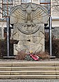
Fallen war memorial

Memorial stone for Karl Uhlig

Memorial column of the flood of the century


Culture and sights
- see also: List of cultural monuments in Burkhardtsdorf
- Marienkirche from 1812 in the district of Meinersdorf
- Lanz Bulldog Museum with a restored Richard Hartmann stationary steam engine
- Book printing museum
- Eibenberg village church
- Saxon postal mileage pillar from 1723
- Historic half-timbered house with sundial
- Medieval resting place Tischl in the Abtwald on Gelenauer Flur
- Kemtau rocks (592 m above sea level) on Gelenau corridor
- Landscape protection area and natural monument Eckardtteiche and Alte Zwönitz
- Wurzelbach wetlands
- Luther oak , about 250 years old
Personalities
Sons and daughters of the church
- Osmar Schindler (1867–1927), painter and academy professor in Dresden
- Horst Strohbach (1886–1978), local history researcher and member of the SED district council
Worked in the community
- Otto Schüngel, foam producer (Schüngel-Chemie KG)
literature
- Falk Drechsel: Burkhardtsdorf through the ages , Art and History Association Burkhardtsdorf 2009. DNB 994314949
- Richard Steche : Burkhardsdorf. In: Descriptive representation of the older architectural and art monuments of the Kingdom of Saxony. 7th issue: Amtshauptmannschaft Chemnitz . CC Meinhold, Dresden 1886, p. 7.
Web links
- Municipal administration Burkhardtsdorf
- Burkhardtsdorf in the Digital Historical Directory of Saxony
Individual evidence
- ↑ Population of the Free State of Saxony by municipalities on December 31, 2019 ( help on this ).
- ↑ Results of the 2019 municipal council elections
- ↑ On the weekend: Wrong labels
- ↑ Saxon Union successful in mayoral elections. (No longer available online.) Formerly in the original ; accessed on May 15, 2018 . ( Page no longer available , search in web archives ) Info: The link was automatically marked as defective. Please check the link according to the instructions and then remove this notice.

Amtsberg | Annaberg-Buchholz | Aue-Bad Schlema | Auerbach | Bear Stone | Bockau | Börnichen / Erzgeb. | Breitenbrunn / Erzgeb. | Burkhardtsdorf | Crottendorf | Deutschneudorf | Drebach | Ehrenfriedersdorf | Eibenstock | Parents | Gelenau / Erzgeb. | Geyer | Gornau / Erzgeb. | Gornsdorf | Großolbersdorf | Großrückerswalde | Grünhain-Beierfeld | Grünhainichen | Heidersdorf | Hohndorf | Jahnsdorf / Erzgeb. | Johanngeorgenstadt | Jöhstadt | Königswalde | Lauter-Bernsbach | Loessnitz | Lugau | Marienberg | Mildenau | Neukirchen / Erzgeb. | Niederdorf | Niederwürschnitz | Oberwiesenthal | Oelsnitz / Erzgeb. | Olbernhau | Pockau-Lengefeld | Raschau-Markersbach | Scheibenberg | Schlettau | Schneeberg | Schönheide | Schwarzenberg / Erzgeb. | Sehmatal | Seiffen / Erzgeb. | Stollberg / Erzgeb. | Column green | Tannenberg | Thalheim / Erzgeb. | Thermal bath Wiesenbad | Thum | Selva | Zschopau | Zschorlau | Zwönitz