
Tannenberg (Saxony)
| coat of arms | Germany map | |
|---|---|---|

|
Coordinates: 50 ° 36 ' N , 12 ° 57' E |
|
| Basic data | ||
| State : | Saxony | |
| County : | Erzgebirgskreis | |
| Management Community : | Geyer | |
| Height : | 498 m above sea level NHN | |
| Area : | 7.97 km 2 | |
| Residents: | 1101 (Dec. 31, 2019) | |
| Population density : | 138 inhabitants per km 2 | |
| Postal code : | 09468 | |
| Area code : | 03733 | |
| License plate : | ERZ, ANA, ASZ, AU, MAB, MEK, STL, SZB, ZP | |
| Community key : | 14 5 21 610 | |
| Community structure: | 2 districts | |
| Address of the municipal administration: |
Rittergut 1 09468 Tannenberg |
|
| Website : | ||
| Mayor : | Christoph Neubert (WV) | |
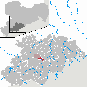
| Location of the municipality of Tannenberg in the Erzgebirge district | ||
  |
||

Tannenberg is one of the smallest communities in the Erzgebirge district .
geography
location
Tannenberg is located in the Middle Ore Mountains in the valley of the Zschopau , which here, coming from the northwest, includes the Geyerbach and then the Greifenbach . The highest point of the place is the "Bone" at 641 m. The state roads S222 and S267 lead through the town.
Neighboring communities
The town is bordered by Ehrenfriedersdorf in the north, the Wiesenbad thermal baths in the east, Schlettau in the south, Elterlein in the south-west and Geyer in the west .
structure
The Siebenhöfen district belongs to Tannenberg .
Geographical particularities
Tannenberg is the geographic center of the newly formed district of Erzgebirge on August 1, 2008. The point is located directly on the European long-distance hiking trail Eisenach-Budapest
history
Local development


.jpg)
.jpg)
A document from 1162 shows that Emperor Barbarossa took possession of the then undeveloped border forest south of Freiberg and at the same time ordered securing of the border routes over the Ore Mountains to Bohemia . The construction of the Tannenberg castle complex with the pass claus tower may be related to this arrangement. The Pass Clause Tower, which was probably built at the beginning of the 12th century, is considered to be the oldest building in the Altlandkreis Annaberg .
The forest hoof village Tannenberg was first mentioned in 1411. In that year, the Belberg (Pöhlberg) lordship with the part of Tannenberg to the right of the Zschopau was pledged to the Wettins by the Burgrave of Meißen and Count of Hartenstein, Heinrich I von Hartenstein . The half of Tannenberg lying to the left of Zschopau belonged to the Tannenberg manor, which at that time was subject to a loan obligation to the Selva Lordship . An earlier affiliation of this part of Tannenberg to the Greifenstein rule is disputed. During the invasion of Saxony by the Hussites , the Tannenberg castle complex was destroyed, except for the Passklausenturm, the wooden structures and extensions of which were also destroyed in the attack. The Lords of Tannenberg had the Tannenberg manor built by 1430, which ruled the place until the 19th century. The manor, which has been the political and economic center of the town for over 500 years, was destroyed in the Thirty Years War and damaged again by fire in 1883. At the end of the 15th century, both districts of Tannenberg were acquired by Matthes von Reizenstein .
The Zainhammer , probably built around 1500, was first mentioned around 1600 with the owner Adam Martin. In 1765 it was named as a gun hammer, which was owned by Johann Adolf Martin. Between 1809 and 1836 the Tannenberg Zainhammer was owned by the British Evan Evans , who developed his spinning machines here with the help of foundries, blacksmiths and metalworking workshops. In 1812 Evans built a cotton mill in the Siebenhöfen settlement belonging to Tannenberg. Over the years the textile industry became the main trade in the municipality. Other smaller metal, plastic and paper processing companies also settled down. Other companies in the textile industry were the CF Höffer cotton spinning mill (1838) and the Kunstseiden AG (from 1927). In the 19th century, Eberhard Börner set up a twisting mill in Zainhammer . Under Hermann Lißner, the hammer was rebuilt into its current form between 1897 and 1899. Lißner produced trimmings here . At the end of the 1940s, Curt Kulb built a spruce needle press and manufactured the famous Fiseesa bath salt until 1975. Between 1888 and 1967 Tannenberg and Siebenhöfen were connected to the rail network via the narrow-gauge railway Schönfeld-Wiesa-Meinersdorf through the stations Tannenberg Ost , Tannenberg , Obertannenberg and Siebenhöfen .
Tannenberg belonged to the Electoral Saxon or Royal Saxon office of Selva until 1856 . From 1856 the place with the district Siebenhöfen belonged to the Geyer court office and from 1875 to the district administration Annaberg . In 1912 the manor became the seat of the Tannenberg municipal office.
As a result of the second district reform in the GDR , the municipality of Tannenberg with its Siebenhöfen district became part of Annaberg in the Chemnitz district (renamed Karl-Marx-Stadt district in 1953 ), which was continued as the Saxon district of Annaberg from 1990 and was added to the Erzgebirgskreis in 2008 . The geographical center of the Erzgebirgskreis, which is located in the area of the municipality Tannenberg, was set up on the occasion of the foundation of the Erzgebirgskreis.
Population development
On October 3, 1990, Tannenberg had 1,255 inhabitants. The following population figures refer to December 31 of the previous year:
|
|
|
|
|
|
politics
- FWBF : 8
- CDU : 2nd
Municipal council
Since the municipal council election on May 26, 2019 , the 10 seats of the municipal council have been distributed among the individual groups as follows:
- Free voters Bürgerforum e. V. (FWBF): 8 seats (share of votes: 73.0%)
- Christian Democratic Union of Germany (CDU): 2 seats (share of votes: 27.0%)
The turnout was 77.5% (2014: 68.8%).
mayor
Christoph Neubert was re-elected as mayor in June 2015 and thus confirmed in office.
Culture and sights
- see also: List of cultural monuments in Tannenberg
- Pass-claus tower with a three-sided moat
- late Gothic church of St. Christophorus with a carved altar from 1521 by Christoph Walther I and children's grave plates and an epitaph from the 16th century
- Zainhammer Tannenberg, built around 1500
Economy and Infrastructure
In terms of traffic, Tannenberg is connected to the federal road network via a state road from Schlettau and Schönfeld . Between 1888 and 1967, Tannenberg was connected to the rail network with three stations at times via the Schönfeld-Wiesa-Meinersdorf narrow-gauge railway.
Personalities
- Evan Evans (1765–1844), mechanical engineer and entrepreneur, founder of the cotton mill in Siebenhöfen
- Eli Evans (1805–1882), entrepreneur in Siebenhöfen and politician
- Carl-Heinz Westenburger (1924–2008), painter and graphic artist
literature
- Hermann Lungwitz : The history of the manor Tannenberg near Geyer. Forays through the history of the Upper Ore Mountains. Issue 44. Tannenberg 2000, new edition edited by Egon König ( PDF 498 KB )
- Richard Steche : Tannenberg. In: Descriptive representation of the older architectural and art monuments of the Kingdom of Saxony. 4th booklet: Official Authority Annaberg . CC Meinhold, Dresden 1885, p. 89.
Web links
- official website of the municipality
- Literature about Tannenberg in the Saxon Bibliography
- Tannenberg in the Digital Historical Directory of Saxony
- Siebenhöfen in the Digital Historical Directory of Saxony
Individual evidence
- ↑ Population of the Free State of Saxony by municipalities on December 31, 2019 ( help on this ).
- ^ The culture mile Geyer Tannenberg ( Memento from July 21, 2004 in the Internet Archive )
- ^ The rule of Pöhlberg in a historical book
- ↑ The rule of Greifenstein on the website of Heiko Gödel
- ↑ The Tannenberg Manor at www.sachsens-schlösser.de
- ↑ The Zainhammer Tannenberg on the website of the Geyer-Tannenberg culture mile
- ^ Karlheinz Blaschke , Uwe Ulrich Jäschke : Kursächsischer Ämteratlas. Leipzig 2009, ISBN 978-3-937386-14-0 ; P. 68 f.
- ^ The official authority Annaberg in the municipal register 1900
- ↑ Source: State Statistical Office of the Free State of Saxony
- ↑ Results of the 2019 municipal council elections
- ↑ https://www.statistik.sachsen.de/wpr_alt/pkg_s10_bmlr.prc_erg_bm?p_bz_bzid=BM151&p_ebene=GE&p_ort=14521610
- ↑ Private website about the Zainhammer Tannenberg

Amtsberg | Annaberg-Buchholz | Aue-Bad Schlema | Auerbach | Bear Stone | Bockau | Börnichen / Erzgeb. | Breitenbrunn / Erzgeb. | Burkhardtsdorf | Crottendorf | Deutschneudorf | Drebach | Ehrenfriedersdorf | Eibenstock | Parents | Gelenau / Erzgeb. | Geyer | Gornau / Erzgeb. | Gornsdorf | Großolbersdorf | Großrückerswalde | Grünhain-Beierfeld | Grünhainichen | Heidersdorf | Hohndorf | Jahnsdorf / Erzgeb. | Johanngeorgenstadt | Jöhstadt | Königswalde | Lauter-Bernsbach | Loessnitz | Lugau | Marienberg | Mildenau | Neukirchen / Erzgeb. | Niederdorf | Niederwürschnitz | Oberwiesenthal | Oelsnitz / Erzgeb. | Olbernhau | Pockau-Lengefeld | Raschau-Markersbach | Scheibenberg | Schlettau | Schneeberg | Schönheide | Schwarzenberg / Erzgeb. | Sehmatal | Seiffen / Erzgeb. | Stollberg / Erzgeb. | Column green | Tannenberg | Thalheim / Erzgeb. | Thermal bath Wiesenbad | Thum | Selva | Zschopau | Zschorlau | Zwönitz