Geyer
| coat of arms | Germany map | |
|---|---|---|

|
Coordinates: 50 ° 37 ' N , 12 ° 55' E |
|
| Basic data | ||
| State : | Saxony | |
| County : | Erzgebirgskreis | |
| Management Community : | Geyer | |
| Height : | 600 m above sea level NHN | |
| Area : | 18.56 km 2 | |
| Residents: | 3403 (Dec. 31, 2019) | |
| Population density : | 183 inhabitants per km 2 | |
| Postal code : | 09468 | |
| Area code : | 037346 | |
| License plate : | ERZ, ANA, ASZ, AU, MAB, MEK, STL, SZB, ZP | |
| Community key : | 14 5 21 210 | |
| LOCODE : | DE GYR | |
City administration address : |
Altmarkt 1 09468 Geyer |
|
| Website : | ||
| Mayor : | Harald Wendler ( The Left ) | |
| Location of the city of Geyer in the Erzgebirge district | ||
Geyer is a country town in the Erzgebirge district of the Free State of Saxony with about 4000 inhabitants.
geography
Name and geographic location
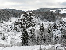
The name is derived from the bird of prey, which was Middle High German "gir" (vulture). In 1395 the place was called "zum Gire", in 1446 "Gyer" and in 1490 "vff dem Geyr". The city is located in the Middle Ore Mountains in the valley of the Geyerbach , which flows into the Zschopau in Tannenberg . The place is almost completely surrounded by forest. The Geyersche Wald also belongs to the municipality . The highest point of the place is the Geyersche high plateau at the television tower Geyer with about 744 m above sea level. NN. Geyer is known among other things for the Geyersche Binge on the Geyersberg . This binge has been a nature reserve since 1935.
Neighboring communities
The municipality borders Ehrenfriedersdorf in the northeast, Tannenberg in the southeast , Elterlein in the south, and Zwönitz in the west and north .
history
From the beginning to the end of the 19th century
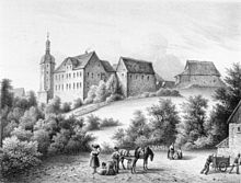
Geyer was first mentioned in a document in 1381. Mining had begun decades earlier around 1315. The defense tower was built in 1395. Geyer received the small market right in 1407, the brewing right in 1453 and in 1467 the place was already mentioned as a town. The first town hall of Geyer was built in 1496. In 1537 the Reformation was introduced in Geyer. The Saxon Elector August I of Saxony donated a large part of his forest to the city of Geyer between 1553 and 1586. In 1564, the production of arsenic began outside the village, near what is now the Greifenbachstauweiher . Today the Hormersdorf Youth Hostel is located on the site . The Mayor of Leipzig Hieronymus Lotter settled in 1566 on the Lehnhof am Geyersberg (Lotterhof) and died there in 1580. The sulfur and vitriol hut of Geyer was first mentioned in 1581.
In 1704 and 1803 the Bingen falls occurred, which caused the underground of the Geyersberg to collapse, which was undermined by mining. In 1730 the Saxon post mile column was built in front of the town hall on the market. In 1809 the Welsh industrialist Evan Evans came to Geyer and built a spinning mill. In 1812 Evans built a cotton mill in the Siebenhöfen settlement belonging to Tannenberg . After his death in 1844, his son Eli Evans (1805–1882) took over the company. His students further developed the technology of the textile industry in Saxony.
The manorial rule over Geyer lay with the town council of Geyer until the 19th century. The mining town of Geyer belonged to the Electoral Saxon or Royal Saxon Office of Selva until 1856 . From 1856 Geyer was the main place of the Geyer court office . From 1875 the city belonged to the district administration of Annaberg . In 1845 the second town hall was consecrated. After the great city fire in 1854, in which 100 houses burned down, the town school was built in 1861/62 and the third town hall was consecrated in 1864. In 1865 the city's volunteer fire brigade was founded and a dynamite factory was built in 1887. The first high-pressure water pipeline was put into operation in 1894 and from 1897 the town was supplied with electricity. In 1888 Geyer got a stop and a terminus as the end point of the narrow-gauge railway from Schönfeld-Wiesa .
20th century
In 1906 the building was extended to Thum station , which was the operational center of the narrow-gauge railway network. With the Greifenbach Viaduct , the largest narrow-gauge railway bridge in Germany was put into operation in 1906. On July 13, 1914, the third town hall on the market square burned down due to lightning. The fourth town hall was not consecrated until 1920.
As a result of the second district reform in the GDR , the city of Geyer became part of Annaberg district in the Chemnitz district (renamed Karl-Marx-Stadt district in 1953 ), which was continued as the Saxon district of Annaberg from 1990 and was added to the Ore Mountains district in 2008. Also in 1952 the tower museum opened in the municipal watchtower. In 1953 the Church of the Resurrection was completed. With the suspension of rail traffic on the Schönfeld-Wiesa-Geyer-Thum section on August 15, 1967, the time of the narrow-gauge railway in Geyer ended. The 192.85 m high television tower of the transmitter Geyer was built from 1972 to 1973 by the Deutsche Post of the German Democratic Republic (GDR).
Since 1990
After the fall of the Wall , the industrial area was established in 1992 and the Geyer Forest was transferred back to the city of Geyer in 1993. The Huthaus an der Binge was built in 1994. In 1998 the Greifensteine leisure pool was opened. In 2006 the Geyer Middle School was closed.
Population development
|
to 1900
|
1901 to 1989
|
1990 to 1999
|
2000 to 2007
|
from 2009 on
|
- Source up to 1989: Digital historical local directory of Saxony, source from 1990: State Statistical Office of the Free State of Saxony (status as of December 31 of the previous year)
politics
City council
Since the municipal council election on May 26, 2019 , the 16 seats of the city council have been distributed among the individual groups as follows:
mayor
Harald Wendler was elected to succeed the late Joachim Weiß (CDU) in March 2011.
Culture and sights
- see also: List of cultural monuments in Geyer
Station area
On the former station grounds, the Saxon class IV K 99 1534-9 steam locomotive commemorates the history of the Schönfeld-Wiesa-Meinersdorf narrow-gauge railway . At the former locomotive shed it stands on a short section of track together with a few wagons. In the locomotive shed there is an exhibition on the narrow-gauge railway to visit.
Tower Museum
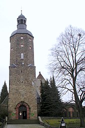
In front of the St. Laurentius Church (in which there is a remarkable group of Mounts of Olives by the Master of the Altar by Geyer ), slightly elevated and therefore clearly defining the cityscape, stands the 42 meter high watchtower. Erected in 1395 as a defense tower, it once offered the inhabitants protection as a refuge in times of war. In the years 1561–1564 the tower got its octagonal structure. The church bells were given their place there and a family of towers found living space. On the initiative of Geyerschen citizens, one of the most beautiful and tallest tower museums in Germany was built in this historic building in 1952. Almost 1000 objects of mountain and town history can be viewed on seven floors.
Natural monuments
Natural monuments in Geyer and the surrounding area are the Geyersche Binge , an old rockslide, the Greifenbachstauweiher and the Greifensteine .
Heimatliederweg
A Heimatliederweg with 19 panels on two routes has existed in Geyerschen Wald since 2012. The song boards with songs in the Erzgebirge dialect were set up by the Erzgebirgszweigverein Geyer.
Regular events
- City festival
- Bingefest
- Erzgebirgsschrammeln
Many cultural festivals are organized by the Förderverein eV Kulturmeile Geyer-Tannenberg .
economy
In the last few years, Deutsche Rohstoff AG has identified large stocks of tin ; future funding is controversial.
Personalities
literature
- Between Zwickauer Mulde and Geyerschem Wald (= values of our homeland . Volume 31). 1st edition. Akademie Verlag, Berlin 1978.
- Geyer . In: Max Grohmann : The Upper Ore Mountains and its cities. P. 1–15 of Chapter 7, Graser, Annaberg 1903
- Friedrich Gustav Blüher: History of the Church Reformation in the mountain town of Geyer , Leipzig 1844 ( digitized version )
- Johannes Falke : History of the mountain town of Geyer. Dresden 1866 ( digitized version )
- Hans Lungwitz: Geyer and the Upper Ore Mountains in legend and history. Bookstore Otto Stopp, Geyer / Annaberg 1900 ( digitized version )
- Richard Steche : Geyer. In: Descriptive representation of the older architectural and art monuments of the Kingdom of Saxony. 4th booklet: Official Authority Annaberg . CC Meinhold, Dresden 1885, p. 74.
Web links
- Geyer in the Digital Historical Directory of Saxony
- Geyersberg in the Digital Historical Directory of Saxony
- Official website of the city of Geyer
- Webcam of the city center, seen from the defense and watchtower
Individual evidence
- ↑ Population of the Free State of Saxony by municipalities on December 31, 2019 ( help on this ).
- ^ Ernst Eichler and Hans Walther : Saxony. All city names and their history , Faber and Faber Verlag, Leipzig 2007, ISBN 978-3-86730-038-4 , p. 65
- ^ Website about the Lotterhof in Geyer
- ^ Karlheinz Blaschke , Uwe Ulrich Jäschke : Kursächsischer Ämteratlas. Leipzig 2009, ISBN 978-3-937386-14-0 ; P. 68 f.
- ^ The official authority Annaberg in the municipal register 1900
- ↑ Alphabetical paperback of all localities of the Kingdom of Saxony [1]
- ↑ [2]
- ↑ https://www.freipresse.de/LOKALES/ERZGEBIRGE/ANNABERG/Wendler-auf-Anhieb-zum-Buergermeister-gewaehlt-artikel7623067.php#
- ^ Website of the Erzgebirgszweigverein Geyer
- ^ Website of the Geyer-Tanneberg Cultural Association
- ↑ Huge tin treasure discovered in the Ore Mountains. welt.de from August 30, 2012, accessed on August 30, 2012


