Thum
| coat of arms | Germany map | |
|---|---|---|

|
Coordinates: 50 ° 40 ′ N , 12 ° 57 ′ E |
|
| Basic data | ||
| State : | Saxony | |
| County : | Erzgebirgskreis | |
| Height : | 505 m above sea level NHN | |
| Area : | 18.9 km 2 | |
| Residents: | 5118 (Dec. 31, 2019) | |
| Population density : | 271 inhabitants per km 2 | |
| Postal code : | 09419 | |
| Area code : | 037297 | |
| License plate : | ERZ, ANA, ASZ, AU, MAB, MEK, STL, SZB, ZP | |
| Community key : | 14 5 21 640 | |
| City structure: | 3 districts | |
City administration address : |
Rathausplatz 4 09419 Thum |
|
| Website : | ||
| Mayor : | Michael Brändel ( FDP ) | |
| Location of the city of Thum in the Erzgebirge district | ||
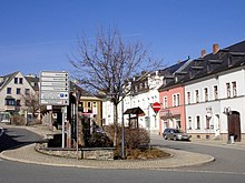
Thum is a city in the Saxon Erzgebirgskreis .
geography
The city of Thum is located on the Jahnsbach. The Waldhufendorf of the same name joins to the west . To the east is the Herold district, also a forest hoof village. The forest area of the Greifensteine borders the city in the south .
Neighboring communities
Gelenau is located north of Thum , Venusberg in the northeast , Drebach in the east, Ehrenfriedersdorf in the south and Zwönitz and Auerbach in the west .
City structure
Districts of Thum are:
history
The settlement of the Greifenstein area probably took place in the 12th to 13th centuries. In addition to agriculture, Thum was strongly influenced by mining until the 16th century, with tin in particular, but also silver and lead being mined. Thum was first mentioned in a document in 1389. In 1445 the settlement was called a mountain town . In 1469, the Thumer citizens bought the upper and lower jurisdiction , which is to be seen as the acquisition of city rights. In 1542 Friedrich von Schönberg was enfeoffed with Jahnsbach, Thum and Oberdorf, as a result of which there was a lengthy and costly process, especially over the execution of jurisdiction between the Thumer citizens and the Lords of Schönberg . On January 15, 1648, the last battle of the Thirty Years' War in the Electorate of Saxony took place on Thumer Flur . Since the 17th century, the trimmings trade developed in particular . Since the 18th century it has been more and more replaced by the stocking knitting industry.

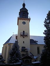
In an air raid on the night of February 14th to 15th, 1945, the town church of St. Anna was destroyed down to the surrounding walls and the interior was destroyed. The reconstruction was carried out using the surrounding walls from 1946 to 1951, the tower was rebuilt.
As part of the municipal reform, the merger of the towns of Herold and Jahnsbach and the town of Thum to form the new town of Thum took place on January 1, 1999.
The Hof zu Thum, the manor and Oberdorf
At the beginning of the 15th century, the Thumer judges were enfeoffed not only with jurisdiction, but also with the free feudal courtyard behind the church and a "desolate courtyard" near the church. The farm's possessions probably extended to the farm meadows in Jahnsbach and the Thumer Kommunwald. The Lehnhof partly included the surrounding mines, a stamping mill and a smelter. In addition to the jurisdiction at the end of the 15th century, the court and the "desert court yard" were also transferred to the city of Thum.
In addition to the surrounding houses, Herold, the lime works , the forester's houses, the bone manor and part of Drebach belonged to the manor , formerly also known as the “Edelhof beim Elend” . The Rittergutsgemeinde (later also called Dorf Thum ) was politically and legally independent of the town of Thum until the 19th century. In 1879 it was dissolved, with the houses being divided between the town of Thum and Herold. The manor house of the manor was sold to the city of Thum in 1882 and has served as the town hall ever since.
The former village of Oberdorf , now called Oberthum, adjoins the city in the north and was an administrative independent place until 1822.
Steam brewery
The old Thumer brewery was founded in the 14th century and was owned by the church until 1546 and was then handed over to the city. In 1882 the civil brewing association dissolved and the master brewer William Böttger bought the building and the entire inventory. In 1898 Böttger had a new brewery built and was able to increase production from 10,000 hectoliters to 15,000 hectoliters. On July 30, 1926, William Böttger's widow sold the brewery to the city, but the city could not find a new buyer. Thus ended the almost 600-year brewing history in Thum. In 2000 the brand was revived under the name Thumer Lager ; The beer is brewed according to the original recipe of the Thumer Dampfbrauerei, however, in a Chemnitz brewery.
Population development
On October 3, 1990, Thum had 6,551 inhabitants. The population figures refer to December 31 of the previous year.
|
1993 to 1997
|
1997 to 2002
|
2003 to 2007
|
from 2009 on
|
- Source: State Statistical Office of the Free State of Saxony
Memorials
- Burial and memorial plaque in the cemetery of the district Herold for a Hungarian Jew who in the satellite camp Venusberg of Flossenburg concentration camp was killed
- A memorial cross in the cemetery of the Thum district commemorates all victims of fascism
Churches and denominations
- Evangelical Lutheran parishes in Thum, Jahnsbach and Herold
- Evangelical Free Churches ( Brethren ) in Thum and Herold
- Regional church community in Thum and in Jahnsbach
- Methodist Church in Herold
- Communion in Christ Jesus in Thum
The Chapel of the United Methodist Church, the Roman Catholic chapel named after Johannes Maria Vianney and the New Apostolic parish in Thum have since been given up.
The congregation of the Roman Catholic Church then met for regular services on Tuesday and Saturday in the former Methodist Church, which was acquired by a funeral home in 2009 and demolished in 2014 due to structural damage. Today she meets in the rooms of the Evangelical Free Church community.
politics
City council
Since the municipal council election on May 25, 2014 , the 18 seats of the city council have been distributed among the individual groups as follows:
- Citizens' list (BL): 8 seats
- CDU : 6 seats
- Association of youth wind orchestra of the city of Thum e. V. (JBO): 2 seats
- LEFT : 2 seats
mayor
Michael Brändel has been mayor since 2006 (non-party).
coat of arms
The current coat of arms was adopted by the city council on May 2, 2000 after Jahnsbach and Herold were incorporated.
The herald in the left part of the coat of arms stands for the Herold district. The tower in the lower part represents the city of Thum. The tree in the left field stands for Jahnsbach and is intended to represent a judgment or life tree. Flails and iron on a white background represent the former mining industry.
Town twinning
Thum's twin town is Žatec in the Czech Republic.
Attractions
- see also: List of cultural monuments in Thum
- City Church St. Annen: destroyed in 1945, rebuilt from 1947 to 1951. The altar structure comes from Thierbaum (former Grimma district ).
- Town hall (former manor)
- Cactus plant
- Zoo
- Saxon post mile column from 1727
- Royal Saxon milestones from 1865 in Jahnsbach and Herold
- former lime works in Herold
- Carving museum in Jahnsbach
traffic
The federal highway 95 runs through Thum .
In 1886, Thum received a railway connection through the narrow-gauge railway Wilischthal-Thum . The Thum station, inaugurated in 1906, was the operational center of both routes (“Thumer Netz”) after the construction of the Schönfeld-Wiesa-Meinersdorf narrow-gauge railway , which was shut down between 1967 and 1975.
leisure offers
Sports
- Football and tennis courts
- Bowling alley
- Riding arena
- Winter sports
- Sports stadium
Folk art
- Jahnsbach carving association
- Lace clubs in the districts of Jahnsbach, Thum and Herold
Meetings and leisure activities
- Leisure and family center in the Thum district
- Youth club in Jahnsbach
societies
Sports
The largest sports clubs in the area are the SV Jahnsbach , the Herolder SV , the TBV 08 Thum and the LV 90 Thum as well as the LSV Waldfrieden Thum for running enthusiasts. There is also a table tennis, chess and bowling club that are active in different leagues.
Culture
- Carving club
- Lace clubs
- Mountain Brotherhood Thum e. V.
- Bergkapelle Thum e. V.
- Association of youth wind orchestra of the city of Thum e. V.
Traditionally, the Thumer Orchestertreff takes place every year on the weekend after Whitsun, with more than 1000 musicians in 2008, for example.
Personalities
Others
- The television series Spuk aus outside of the television of the GDR was partly shot in 1987 in Thum.
- The minerals of the Axinitgruppe were also called because of their earlier relatively frequent occurrence around Thum Thumit or Thumerstein referred.
literature
- Karl Alfred Schmidt: Colorful pictures from days gone by. Contributions to the history of the Parochie Thum. Verlag Delitsch, Thum 1900 ( digitized version )
- Richard Steche : Thum. In: Descriptive representation of the older architectural and art monuments of the Kingdom of Saxony. 4th booklet: Official Authority Annaberg . CC Meinhold, Dresden 1885, p. 90.
Web links
- Thum in the Digital Historical Directory of Saxony
Individual evidence
- ↑ Population of the Free State of Saxony by municipalities on December 31, 2019 ( help on this ).
- ^ Heinrich Magirius in "Fate of German Architectural Monuments in the Second World War". Edited by Götz Eckardt, Henschel-Verlag, Berlin 1978. Volume 2, p. 465
- ↑ StBA Area: changes from 01.01. until December 31, 1999
- ↑ http://www.kath-kirche-zschopau.de/index.php?site=gemeinde
- ↑ http://www.nak-mitteldeutschland.de/gemeinde/wiesa/aus-der-chronik/
- ↑ http://www.freipresse.de/LOKALES/ERZGEBIRGE/ANNABERG/Abrissbagger-tilgt-Friedenskirche-aus-dem-Thumer-Stadtbild-artikel9035879.php
- ↑ http://www.heilig-kreuz-annaberg.de/gottesdienste.shtml
- ↑ Results of the 2014 municipal council elections


