Schlettau
| coat of arms | Germany map | |
|---|---|---|

|
Coordinates: 50 ° 34 ' N , 12 ° 57' E |
|
| Basic data | ||
| State : | Saxony | |
| County : | Erzgebirgskreis | |
| Management Community : | Scheibenberg-Schlettau | |
| Height : | 612 m above sea level NHN | |
| Area : | 21.22 km 2 | |
| Residents: | 2368 (Dec. 31, 2019) | |
| Population density : | 112 inhabitants per km 2 | |
| Postal code : | 09487 | |
| Area code : | 03733 | |
| License plate : | ERZ, ANA, ASZ, AU, MAB, MEK, STL, SZB, ZP | |
| Community key : | 14 5 21 520 | |
| LOCODE : | DE SUA | |
City administration address : |
Markt 1 09487 Schlettau |
|
| Website : | ||
| Mayor : | Conny Göckeritz ( Greens ) | |
| Location of the city of Schlettau in the Erzgebirge district | ||
Schlettau is a small town in the Erzgebirge in Saxony .
Location with neighboring communities and urban structure
The city is located at the confluence of the Red Puddle in the Zschopau .
In the east borders Annaberg-Buchholz to the city in the southeast of Sehmatal , south Crottendorf , southwest Scheibenberg , west Elterlein and north Tannenberg . To the north of this is the former Waldhufendorf Dörfel, which has belonged to Schlettau as a district of Dörfel since October 1, 1996 .
history
Development into a settlement
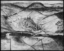
To protect the crossing over the Zschopau and as a way station to the Preßnitzer Pass , the sovereigns had a fort built around 1100. The area belonged to the Schönburgers and was under the sovereignty of the Bohemian king. On March 13, 1351 Friedrich and Bernhard von Schönburg received Hassenstein (Hasištejn), Preßnitz and Schlettau, which is mentioned for the first time in the document (under the name Sleten or Slatin), as a fief. On March 20, 1413, Schlettau came to Grünhain Abbey in an exchange deal . In 1367 Schlettau was called oppidum . In the middle of the 15th century the first city rights were obtained.

In 1515 Schlettau became a free mining town. In 1527/1529 Balthasar Loy and Johannes Bock carried out the Reformation in the region . With the associated dissolution of the Grünhain monastery, Schlettau came under Wettin rule. Due to the important traffic situation, during the Thirty Years' War there were several marauding troops.
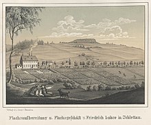
From 1725 the settlers began to grow potatoes on Schlettau's corridors. When the castle was no longer used from the middle of the 18th century, it increasingly fell into disrepair. Extensive renovation work was not carried out until the end of the 19th century. Until then, parts of the castle had been used as a factory building. In 1889, when the Annaberg-Buchholz Süd-Schwarzenberg railway was opened, it was connected to the rail network. In 1930 Schlettau Castle became the property of the city.
19th and 20th centuries
On October 1, 1996, Dörfel was incorporated.
Population development
On October 3, 1990, Schlettau had 2,985 inhabitants. The following population figures refer to December 31 of the previous year:
|
1993 to 1997
|
1998 to 2002
|
2003 to 2007
|
from 2009 on
|
- Source: State Statistical Office of the Free State of Saxony
politics
Municipal council
Since the municipal council election on May 26, 2019 , the 14 seats of the municipal council have been distributed among the individual groups as follows:
- Free voters Citizens Forum (FWBF): 9 seats, share of votes 64.7% (2014: 43.2%)
- CDU : 5 seats, 35.3% of the votes (2014: 39.3%)
The list Schlettau Castle (2014: 10.1%) and Alliance 90 / The Greens (2014: 7.3%) were not available for election in 2019.
mayor
Conny Göckeritz (Greens) prevailed in the mayoral election on June 7, 2015 with 67.9 percent against the then incumbent Axel Bräuer (CDU). Göckeritz is the first mayor of Bündnis 90 / Die Grünen in the Ore Mountains and the second in the Free State of Saxony since Erich Homilius became mayor of Hohenstein-Ernstthal in 1994 .
Town twinning
- Sister city is Místo (place) in the Czech Republic (since 2004)
- City friendship exists with Schnaittach (Middle Franconia)
Culture and sights
- The Silberstraße holiday route runs through the city .
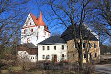
- The most famous tourist destination is Schlettau Castle . The museum, which has been housed there since the GDR era, shows, among other things, historical exhibits of the trimmings that were made in Schlettau.
- In the center of the city there is a restored Kursächsische post mile column in front of the Reut (h) erhaus. This is a baroque building from 1701 on Schloßplatz.
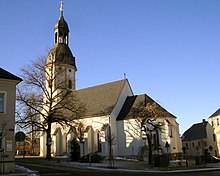
- The Protestant parish church St. Ulrich , which together with the community Walthersdorf forms a parish, dominates the city center (see picture). It began in the early 15th century and is a listed building. According to legend, a stone placed on the outside wall of the church is said to show the face of a monk .
The choir of this church is remarkable . - It should not go unmentioned that in the direct center of the village there are still numerous residential buildings from the 17th and 18th centuries, which were placed under monument protection by the Saxon Monument Office in the 21st century .
- The town hall (address Markt 1), with a small clock tower , a slate roof and more in the shape of a church, is a branch of the fulfilling municipality of Scheibenberg .
- At the nature conservation center there is a memorial stone for a Soviet forced laborer known by name , who was murdered by two police officers in 1945 because of practical help for his fellow sufferers.
Economy and Infrastructure
economy
The largest operation in the village is a quarry for the extraction of twig mica gneiss .
The herbal schnapps Grubenfeuer is exclusively made in Schlettau .
The place is also known for the tradition of lace making .
traffic
Schlettau is on federal highway 101 . The old road connection to the Preßnitzer Pass from Grünhain Abbey no longer has any national significance.
Passenger traffic on the Annaberg-Buchholz-Schwarzenberg (- Aue) railway line that runs through the city was discontinued in 1997, and the route is only used several times a year by the Saxon Railway Friends Association (VSE) in Schwarzenberg for special trips ( Erzgebirge observation railway ). This was once the starting point of the branch line to Crottendorf , which used the route to Annaberg-Buchholz as far as Walthersdorf.
Personalities
literature
- City administration of Schlettau: Festschrift for the first documentary mention of the city of Schlettau 650 years ago - Chronicle of the city of Schlettau 1351–2001. Bergstraße publishing house: Annaberg-Buchholz, 2001.
- From Annaberg to Oberwiesenthal (= values of the German homeland . Volume 13). Schlettau, Krs. Annaberg. Edition. Akademie Verlag, Berlin 1968, pp. 106–112.
- Richard Steche : Schlettau. In: Descriptive representation of the older architectural and art monuments of the Kingdom of Saxony. 4th booklet: Official Authority Annaberg . CC Meinhold, Dresden 1885, p. 86.
- Schlettau , in: Max Grohmann : The Upper Ore Mountains and its cities . Graser, Annaberg 1903.
- Johann Gottfried Gehlofen: Chronicle of the city of Schlettau. Schlettau 1867. ( digitized version )
- Schlettau near Annaberg . In: August Schumann : Complete State, Post and Newspaper Lexicon of Saxony. 10th volume. Schumann, Zwickau 1823, pp. 345–353.
Web links
- Web presence of the city of Schlettau
- Schlettau in the Digital Historical Directory of Saxony
- Literature about Schlettau in the Saxon Bibliography
Individual evidence
- ↑ Population of the Free State of Saxony by municipalities on December 31, 2019 ( help on this ).
- ^ StBA: Changes in the municipalities in Germany, see 1996
- ↑ Election victory without Veggie Day . Free press , June 8, 2015.
- ↑ Homepage Church Schlettau
- ↑ On the history of the Church of St. Ulrich
- ^ Georg Piltz: Art guide through the GDR. 4th edition, Urania-Verlag, Leipzig / Jena / Berlin. 1973; P. 464.
- ↑ The monk's face on the church website
- ^ City administration Schlettau .


