
Scheibenberg (Ore Mountains)
| Scheibenberg | ||
|---|---|---|
 Basalt columns ("organ pipes") on the Scheibenberg |
||
| height | 807.2 m above sea level NHN | |
| location | Erzgebirgskreis , Saxony ( Germany ) | |
| Mountains | Ore Mountains | |
| Coordinates | 50 ° 32 '14 " N , 12 ° 55' 26" E | |
|
||
| Type | Table Mountain | |
| rock | basalt | |
| particularities | Observation tower | |

The Scheibenberg is a mountain in the Ore Mountains ( Saxony ) with a height of 807.2 m above sea level. NHN . It is located immediately southeast of the city of the same name in the Erzgebirge district of Scheibenberg . Together with the Bärenstein and the Pöhlberg , the mountain is one of the three large basalt mountains in the Western Ore Mountains . The Scheibenberg is a selected site for the proposed candidacy for the UNESCO World Heritage Site of the Ore Mountains Mining Region .
Geology and mining
As the erosion residue of a tertiary lava flow , like its neighbors Bärenstein and Pöhlberg , it consists mainly of basalt . According to modern petrological classification, however, the "basalt" of the Scheibenberg must be referred to as augite - nephelinite . This is in the form of particularly imposing pillars up to 30 meters high (popularly: "organ pipes") on the Scheibenberg. All three mountains are an example of the relief reversal . Originally, lava poured into a lower section of the terrain and cooled there. Over time , the surrounding rock eroded faster than the harder basalt, so that today the former valley protrudes over the surrounding area.
In 1787/88 the mineralogist Abraham Gottlob Werner carried out investigations on the Scheibenberg. He found that the basalt lay on layers of weathered gravel , sand , clay and weathered basalt (Wackerstein). From this, Werner concluded the marine origin of the rock and founded the geological theory of Neptunism . He assumed that all rocks were formed as sedimentary rocks from the water of the oceans.
Below the "Organ Pipes", a basalt educational trail provides information on the special features of the Scheibenberg natural monument using 15 educational boards. The mountain was awarded in May 2006 by the Academy of Geosciences in Hanover eV (AGH) as one of the 77 most important national geotopes in Germany.
As early as the early 19th century, a layer of clay standing on the basalt border and partly 2 meters thick was quarried and used to make pots and ovens. The up to 40 meters thick layer of sand lying under the clay was also removed and a. used as cleaning and scouring sand.
The basalt itself has also been extracted since at least the 19th century. In the 1880s, mining took on industrial forms. From 1914, three quarries were operated on the north side of the Scheibenberg. For the basalt mining, drill holes up to 3 meters long were drilled into the clay and sand layer under the basalt, which were then used to blast off the "organ pipes". The extracted rock was removed by a 1,300 meter long cable car to the Annaberg - Schwarzenberg railway line . The basalt was v. a. used as gravel in road and railroad construction. Further quarrying was forbidden in 1936 by the Chemnitz district administration , as the dismantling of the mountain was at risk.
history
The Scheibenberg has been owned by the city of Scheibenberg since 1558. Due to its striking shape and height, it was mentioned in various map representations and historical descriptions, so u. a. in the map by Matthias Oeder and the writings of Christian Lehmann and Johann Friedrich Wilhelm von Charpentier . While Charpentier described the mountain as wooded in 1778, the Scheibenberg was largely treeless in the middle of the 19th century. In 1875, the reforestation of the mountain began.
In the course of the Royal Saxon state surveying, a second-order surveying station was built on the Scheibenberg in 1864. The surveying stone was moved around 65 meters to the south-southeast in 1994 as a result of the construction of the observation tower.
As part of the general tourist development of the Ore Mountains, a lookout tower made of basalt and bricks was built on the summit of the Scheibenberg in 1891. The 26 m high tower, the viewing platform was almost 21 m high, was named after the Saxon Queen Carola (1833–1907). The tower had to be blown up in 1971 due to its dilapidation. In 1993/94, a 29.2 m high new building was built, the octagonal shape of which is modeled on the striking basalt columns of the mountain. If the conditions are good, the viewing platform at a height of 22.44 m offers a wide and comprehensive panoramic view.
In the course of the construction of the Carola Tower, the first mountain inn opened in 1892. The initially modest building was rebuilt and expanded several times in the following decades. The current building was built in 1992/93 as part of a comprehensive modernization.
historical depiction of the unforested Scheibenberg by Wilhelm Dillich (around 1626/29)

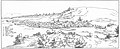
City and Mountain Scheibenberg (around 1900)
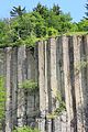
Detailed view of the "organ pipes"

Station stone of the Royal Saxon Triangulation from 1864

Mountain inn and observation tower
.jpg)
...IMG_9852WI.jpg)


Flora and fauna
The representatives of the animal world on the Scheibenberg include the kestrel , the sand lizard and the stone marten . The flora corresponds to that of a typical mixed forest with spruce stands. To find include silk Elba start that baneberry , mercurialis , the Foxglove , the Genuine toadflax , the Luzula sylvatica and tansy .
natural reserve
After the quarry was closed, it was already in 1937 that the Scheibenberg was protected by the Reich Forestry Department. Today the mountain is part of the FFH area "5443-301 Mittelerzgebirgische Basaltberge". The need for protection results from " ... larger occurrences of silicate rubble heaps and small-scale typical silicate rocks with cryptogamatic vegetation as well as mountain heaths, typical ash-maple canyon forests, large stock of relatively well-developed grove-beech forests ... ".
Routes to the summit
A drivable mountain road leads from the town of Scheibenberg to the mountain inn. In the middle position, the lower mountain path leads around the mountain. Several summit trails branch off from this path, the most famous of which is the Zahmsteig, located on the southeast slope. From 1931 to 1934, Ottomar Zahm, a citizen of the city of Scheibenberg, who was unemployed at the time, paved over 300 steps in laborious and unselfish manual work through a basalt block field that was difficult to access - almost in secrecy until the end of the climb.
Panoramic view from the summit


literature
- From Annaberg to Oberwiesenthal (= values of the German homeland . Volume 13). 1st edition. Akademie Verlag, Berlin 1968.
- Erzgebirgszweigverein Scheibenberg (Ed.): Scheibenberg observation tower. Heidler & Fahle, Scheibenberg o. J. [approx. 1995]
- Rolf Strienitz: How high are the “organ pipes” on the Scheibenberg really? In: Erzgebirgische Heimatblätter Heft 5/2008, pp. 6–9. ISSN 0232-6078
- Reinhart Heppner , Jörg Brückner , Helmut Schmidt: Saxon-Bohemian panoramic mountains of the western Ore Mountains in words and pictures with tourist information. Geiger, Horb am Neckar 2001, pp. 69-72. ISBN 3-89570-593-4
Web links
- Scheme of the relief reversal on the Scheibenberg
- Flyer of the basalt educational trail (PDF; 1.5 MB)
- The secret of the organ pipes (PDF; 1.1 MB)
- Signs of the basalt educational trail (PDF; 363 kB)
- Scheibenberg observation tower
- Saxon State Office for Environment, Agriculture and Geology
Individual evidence
- ↑ a b Map services of the Federal Agency for Nature Conservation ( information )
- ↑ Modern treasure trove on the Scheibenberg , Official Journal Scheibenberg with Oberscheibe 8th volume / number 78, April 1997, pp. 10-11
- ↑ Technical data of the tower on the website: Scheibenberg observation tower
- ↑ NATURA 2000 Basalt Mountains in the Middle Ore Mountains