Fichtelberg (Ore Mountains)
| Fichtelberg | ||
|---|---|---|
| height | 1214.79 m above sea level NHN 1 | |
| location | Ore Mountains , Saxony , Germany | |
| Mountains | Ore Mountains | |
| Dominance | 3.4 km → Klínovec | |
| Notch height | 135 m | |
| Coordinates | 50 ° 25 '46 " N , 12 ° 57' 15" E | |
|
|
||
| rock | Muscovite slate | |
| particularities | highest mountain in the German part of the Ore Mountains and in Saxony - Fichtelberghaus with observation tower - weather station with observatory - Fichtelberg suspension railway - Fichtelberg railway |
|
The Fichtelberg in Oberwiesenthal in the Ore Mountains is 1,214.79 meters above sea level. NHN 1 the highest mountain in Saxony . Together with the nearby Klínovec ( Keilberg ; 1243.7 m nm ) on the Czech side, it forms the most important winter sports center in the Ore Mountains .
geography
Location and surroundings
The Fichtelberg rises within the Middle Ore Mountains in the Ore Mountains / Vogtland Nature Park around 1.5 km north of the state border . At the southern foot of the mountain, the Oberwiesenthal health resort in the Pöhlbach valley is Germany's highest town. About 750 m to the south-south-west is the little Fichtelberg (also called Hinterer Fichtelberg ; 1205.6 m ) as a less prominent secondary peak of the Fichtelberg . About 4 km to the south-southeast rises with the Czech Klínovec ( Keilberg ; 1244 m ) the highest point in the Ore Mountains. Numerous streams have their origin in the wet basins and raised bogs on the Fichtelberg . The most important river that rises there is the Zschopau .
geology
The Fichtelberg consists essentially of light-colored crystalline rocks, in particular from a variety of muscovite slate . This rock consists mainly of quartz and muscovite , orthoclase and biotite are partly contained. Additions include rutile , garnet , tourmaline , hematite and ilmenite .
Summit development
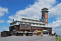
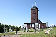
On the summit of the Fichtelberg there is the Fichtelberghaus with an observation tower , a weather station and a striking station of the Royal Saxon Triangulation of 1864, with which measurements of regional and national importance were carried out. The Fichtelberg suspension railway leads over the eastern flank of the mountain from Oberwiesenthal to the summit plateau.
Flora and fauna
Forest history
The extensive spruce forests surrounding the Fichtelberg area have been subject to constant use and thus change since the area was first settled. The original tillering, also in the high and ridge positions, was fundamentally different. Pollen analyzes from the Gottesgaber Hochmoor provided informative results for the development. The main tree species of the Hercynian mixed mountain forest , silver fir ( Abies alba ), red beech ( Fagus sylvatica ) and spruce ( Picea abies ) were represented in roughly equal proportions up to the ridges of about 30 percent. In old church chronicles and forest taxation there are descriptions of the original forest condition: The Fichtelberg had a mixed forest of the tree species mentioned above. The now dominant spruce is primarily a result of human influence. Improper management such as clear-cutting and high game populations pushed fir and beech trees further and further out of the forests and unilaterally favored the spruce. With the start of state forestry in Saxony at the beginning of the 19th century, the tree species composition changed drastically. The management oriented towards the highest net yield had the pure spruce stand in the clear-cutting operation as ideal. Other tree species are gradually being planted.
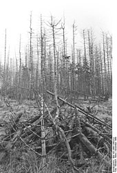
Especially in the 1970s and 1980s, the entire Ore Mountains, especially Fichtel and Keilberg, suffered from pollutants from the air, resulting in the phenomenon known colloquially as " forest dieback ", technically known as "novel forest damage". Pollutant emissions from lignite power plants and chemical plants in the GDR, the CSSR and Poland played an important role . Most of the spruce trees that grow on and around the Fichtelberg today have been planted there since the 1970s, so visitors can see a young forest. Many of the high-performance power plants in the Czech Republic , which are within sight of the Fichtelberg in the North Bohemian Basin , are still operated with lignite. By installing effective filter systems in the 1990s, the SO 2 and NO x emissions of Czech coal-fired power plants are drastically reduced compared to the time before 1990. In the black triangle around the border triangle between Germany, the Czech Republic and Poland, between 1990 and 1998, SO 2 emissions from lignite power plants were reduced by 85% and NO x pollution by 50%. The North Bohemian lignite power plants Počerady and Tušimice were still considered to be the two largest air polluters in the Czech Republic in 2019 due to their high CO 2 emissions. Because of the strong, persistent acidification of the soils , they are still regularly limed in the entire Ore Mountains .
A "new forest dieback" (after a phase of forest recovery) was first mentioned in 2007. The Max Planck Institute for Biogeochemistry in Jena found in 2014 that the effects of pollutant emissions up to 1990 on the water balance in Saxony were considerably more serious than the effects of climate change observed up to 2009. The trees that have regrown since 1990 in the ridges of the Saxon low mountain range would have restored the hydrological functions of the forest relatively quickly from 1990 onwards. In 2019, however, the Federation for the Environment and Nature Conservation Germany (BUND) warned against a comprehensive "Forest Die 2.0". Extreme weather, acidic soils, pollutants from the air and inputs from agriculture weakened the trees in Germany, Austria, Poland, the Czech Republic, Slovakia and Switzerland. Insects such as the bark beetle benefited from this, but fungi, viruses and bacteria also spread more easily in the weakened populations. Cornelius Senf from the Humboldt University of Berlin stated: "The forest area affected by tree death has doubled since 1984".
For the Fichtelberg region, it is of particular importance that the Czech Republic is finding it more difficult than Germany to completely abandon lignite as an energy source in the long term.
Botanical peculiarities
The exposed location of the Fichtelberg near the natural tree line offers a good habitat for many rare montane plants. The occurrence of numerous species that occur in the Alps or the tundras of Northern Europe is remarkable , including white tongue , real moon rue , hollow tongue , alpine flat bear and alpine lettuce .
Protected areas
On the Fichtelberg is the 1962 founded and 5.48 sq km conservation area Fichtelberg ( CDDA -No. 320795), on the southern slope, which was founded in 1961, 18.67 hectares large and two-part nature reserve Fichtelberg Schönjungferngrund (CDDA no. 163092) and directly southwest of it the 73.15 hectare large and multi-part nature reserve Fichtelberg-Südhang, established in 1997 (CDDA no. 163093). To the west of this is the one-part Rohr- oder Schilfwiese nature reserve, founded in 1967 on the Kleiner Fichtelberg (CDDA no. 165205). These areas overlap with the fauna-flora-habitat area Fichtelbergwiesen (FFH no. 5543-304).
history
Surname
The mountain was named after a natural spruce forest that existed at the time (see section Forest history ). Georgius Agricola used the Latinized form Pinifer ( Fichtelberg ) in the 16th century .
Fichtelberghaus
A first, albeit unoccupied, reference to a building on the summit of the Fichtelberg can be found in the Historisches Schauplatz by Christian Lehmann , published in 1699, which says:
“It is said that a pleasure and hunting house was built a hundred years ago by the Schoenburg gentlemen / it should stand on it / but now there is nothing left on it / because there may have been little amusement / even a rifle shot and clap of thunder were bad Bang gives / but is swallowed up by the Lufft. "
The first verifiable Fichtelberghaus projected by Oskar Puschmann was built in the years 1888/89 on the plateau of the Fichtelberg. It was opened on July 21, 1889 and an annex was added in 1899. In 1910 the house was enlarged again due to the crowds on the highest mountain in Saxony. With the construction of the Fichtelberg suspension railway in 1924, the number of visitors increased further.
On the evening of February 25, 1963, a fire broke out in the Fichtelberghaus. 180 firefighters from the entire district of Annaberg were alerted and were involved in the fire fighting. Due to heavy snow drifts on the access road, all extinguishing agents had to be brought up to the mountain by suspension railway. Because of the lack of water and a hose line frozen at −15 ° C, which Oberwiesenthal had laid on the mountain, it was not possible to extinguish the fire. The building burned to the ground.
The foundation stone for a new building was laid on June 22, 1965. By the time it opened on July 28, 1967, a new building was built with a sober concrete architecture typical of the GDR and an integrated, unadorned 42 m high observation tower. The GDR made 12 million marks available for the construction on its highest mountain. There was a large self-service restaurant on the ground floor, a grill bar, a concert café and a conference room on the upper floor; these facilities could accommodate a total of 600 guests. Well-known artists contributed to the interior design, so Hans Brockhage designed the wooden walls in the vestibule and the room divider in the self-service. Carl-Heinz Westenburger created a mural for the front wall of the salon, on which he depicted sports life on the Fichtelberg. At the end of the 1990s, the Fichtelberghaus was rebuilt based on the old building and reopened on July 18, 1999. The newly built observation tower is only 31 m high.
Weather station
From 1890 the landlord of the Fichtelberghaus regularly observed the weather. With the increase in tourism, however, he did not have the time, so that the records were incomplete from 1898 and were discontinued in 1910. On the initiative of Paul Schreiber , the head of the Royal Saxon State Weather Station , a permanent weather station was built, which was handed over on December 30, 1915 and began to record the weather on January 1, 1916. It is noteworthy that the weather records were also kept uninterrupted during the Second World War . After 1950, the weather station was expanded into a mountain observatory under the direction of Horst Gäbler . In 1991 it was incorporated into the German Weather Service .
Almost all meteorological parameters have been recorded since 1916 and climatologically the location is representative of the high altitudes of the Ore Mountains. Starting in 2009, the German Weather Service set up a Germany-wide network of twelve climate reference stations, which will continue to record climate changes over the next 100 years with uniform measurement technology and well-trained weather observers. With its long time series, the weather station on the Fichtelberg fulfilled a decisive criterion for the status of such a station. However, since the station is to work fully automatically from 2019, the status of the climate reference station was revoked in 2014. Until then, six employees working for the German Weather Service will take care of the recordings.
From the beginning of the recordings until 2015, the following weather extremes were recorded:
- strongest storm (gusts peak): 216 km / h (January 3, 1976)
- Coldest temperature: −30.4 ° C (February 9, 1956)
- warmest temperature: 30.8 ° C (July 27, 1983)
- most summer days: 13 days during the 2015 European heat waves
- longest duration of sunshine: 1970.4 hours (2003)
- most foggy days: 315 (1951)
- highest snow depth: 3.35 m (March 24 + 29, 1944)
- Earliest snow cover: September 4, 2007
- Latest snow cover: June 17, 1928
Fichtelberg suspension railway

The Fichtelberg suspension railway is the oldest aerial cableway in Germany and went into operation in December 1924. It leads from the valley station ( 905.5 m ) to the mountain station on the summit plateau ( 1208.9 m ). The journey time is three and a half minutes.
At the beginning of July 2010, the Oberwiesenthal city council decided to completely rebuild the railway. The new building was finally abandoned due to a lack of government funding, and the facilities were completely renovated between April 2012 and the start of the 2012/2013 ski season for 1.2 million euros.
Fichtelbergbahn
The Fichtelbergbahn , a Saxon narrow-gauge railway leading from Cranzahl to Oberwiesenthal , which opened in 1897 and whose tracks are 17.349 km long, ends at the southeast foot of the mountain .
Fichtelbergbaude
The Fichtelbergbaude, a building used as a boarding house on the street leading to the Fichtelberg, burned down on November 21, 2009, presumably as a result of arson.
Peace bell
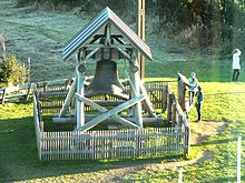
In 2009 suggested Gerd Schlesinger, watchman of the city Schwarzenberg , before a läutbare on the Fichtelberg church bell establish that as a monument to German unity should apply. Their bells should be heard as far as the neighboring Czech Republic and thus also sound for a united Europe. Many private individuals and companies were actively involved in the project or with donations, which was ultimately placed under the patronage of the Annaberg District Administrator Frank Vogel. The cast steel bell with a weight of 1600 kg and the strike tone "d '" was cast as early as 1920. It was owned by the Eifeler foundry Mark from Brockscheid , which it sold to the Lions Club Aue-Schwarzenberg at a low price as its monument contribution.
Sports
The winter sports area on the Fichtelberg is together with that of the Klínovec ( Keilberg ; 1244 m ) the most important winter sports center in the Ore Mountains. The winter sports area is considered to be snow reliable from December to March. The 2006/2007 winter season, when the Fichtelberg only had a cover of snow on 85 percent of all winter days, has so far been considered an absolute exception. In the 2010s, the Fichtelberg was covered with snow on more than 90 percent of the days every season, in many years even on all winter days. However, the maximum snow depths tend to decrease per season. In the 2019/2020 season, the snowfall did not start until December 9, 2019, and by the end of January 2020 the natural snow cover was a maximum of 20 cm high (average natural snow depths of over 50 cm are common on the Fichtelberg in winters). Only because eighteen large snow cannons and 100 snow lances were in use on the slope of the Fichtelberg from the end of November 2019 could it be ensured that the 2019/2020 ski season could officially open there on December 6, 2019.
The Fichtelberg suspension railway and a four- seater chairlift , which lead close to the summit, and the two- person "Himmelsleiterlift" tow lift with several ski slopes, open up the part located on the Fichtelberg. This also includes a toboggan run north-northeast below the summit, the Fichtelbergschanzen southeast on the mountain and the Sparkasse ski arena for cross-country skiers and biathletes located on the lower part of the southwest slope of the Kleiner Fichtelberg . According to the plans of a project group, a cable car called the "Länderschaukel" will be built after 2015, which will connect the peaks and ski areas of Fichtelberg and Klínovec. There is a summer toboggan run next to the valley station of the chair lift .
Every year on the first Saturday in October, the Fichtelberglauf takes place, starting in Neudorf and finishing on the summit plateau. In addition, the Fichtelberg March has been held every May since 2008 . This sports hike, which starts in Chemnitz , leads through Burkhardtsdorf , Geyer and Scheibenberg as well as past the lower basin of the Markersbach pumped storage plant to the top of the mountain. There are 64 km to cover and 1700 meters of altitude to be overcome.
view
The view covers large parts of the central Ore Mountains. Even with visibility less than 20 km, impressive views of Klinovec (Keilberg), located just across the German-Czech border, as well as along the main ridge of the Ore Mountains and into the lower areas on the German side of the Ore Mountains are possible. Beyond the Ore Mountains ridge, the view extends southeast to the mountains of the Bohemian Central Uplands . During autumn and winter inversion weather conditions, the gaze sometimes wanders under a clear sky over a closed cloud cover from which only the highest peaks can be seen. Notably during such weather conditions, the view to 836 m high Milešovka ( Milleschauer ) in the Czech Central Mountains. On a few days a year there is also a distant view of the Fichtel Mountains , the Giant Mountains , the Bohemian Forest , the Bavarian Forest with the Great Arber and in rare cases and often only with binoculars as far as the Brocken in the Harz Mountains .
Landmarks that the observer can use to orientate themselves to when the view is clear are, in addition to the aforementioned mountains and individual mountains, buildings, especially some of the brown coal power plants and their long plumes of smoke in the north Bohemian Egertal .
View in north direction to Crottendorf in the upper Zschopau valley
Distant view from the Fichtelberg summit in east direction to the valley of the Eger in the North Bohemian lignite region
Traffic and walking
The German federal highway 95 leads southeast to southwest past the Fichtelberg, which merges into the Czech Silnice 25 at the state border . From this road axis branches off near the border, still in German territory, the state road 271 and shortly afterwards from this the Fichtelbergstraße , which leads past the Kleiner Fichtelberg to the Fichtelberg summit. There are several parking spaces for cars and buses on the summit and below it. There is a bus connection from Oberwiesenthal there.
The mountain can also be reached via long-distance hiking trails , such as the 526 km long national long-distance hiking trail Zittau - Wernigerode or the 285 km long quality hiking trail Kammweg Erzgebirge - Vogtland . On the 122 km long area hiking trail Zschopautal , most hikers choose the south-north direction from the Fichtelberg to the Zschopau estuary at Technitz .
The Fichtelberg is also a magnet for cyclists and motorcyclists. From the Pöhlbach valley, the B 95 runs with two long serpentines - starting at 830 m - and a short flat section to the Czech border. The road section in the area of the border crossing near the mountain inn Neues Haus ( 1083.2 m ) and the 1.7 km long Fichtelbergstraße lead through a landscape of small trees, which gives a clear impression that you are at over 1000 m altitude is located. The total length of the ascent to the summit is 6,600 m and overcomes an altitude difference of around 380 m.
The somewhat less known but more difficult ascent begins in Rittersgrün and covers an altitude difference of 556 m over a distance of 13.64 km. It leads on the S 271 through the Ehrenzipfel and Zweibach groups of houses and through the village of Tellerhäuser . After crossing it and after a few smaller downhill sections, a long, steep straight stretches out, which becomes flatter until the Fichtelberg junction . Then you drive on the Fichtelbergstraße up to the summit.
Trivia
Fichtelberg has been the name of a planetoid of the solar system since 2002 , which was discovered on January 21, 1999 by astronomers at the Drebach observatory in the Ore Mountains . It now bears the official name (29736) Fichtelberg and moves between the planets Mars and Jupiter around the sun.
The city express train pair 172/175 Karl-Marx-Stadt Hbf - Berlin-Lichtenberg also bore the name of the highest mountain in the GDR.
See also
literature
- From Annaberg to Oberwiesenthal (= values of the German homeland . Volume 13). 1st edition. Akademie Verlag, Berlin 1968.
- Reinhart Heppner , Jörg Brückner , Helmut Schmidt: Saxon-Bohemian panoramic mountains of the western Ore Mountains in words and pictures with tourist information , Horb am Neckar, 2001, pp. 52–54
Web links
Remarks
- 1 The leveling determination of this DHHN92 height was carried out on August 12, 2004 by representatives of the then State Surveying Office of Saxony (now the state enterprise Geobasisinformation und Vermessung Sachsen) (the height refers to the highest point of the Fichtelberg outside of structures).
Individual evidence
- ↑ 20 years after the great death of forests in the Ore Mountains . forstpraxis.de, October 3, 2010
- ↑ OECD : OECD Environmental Assessment Reports: Germany 2001 .
- ↑ Markéta Kachlíková: Počerady coal-fired power plant is the largest air polluter in the Czech Republic . radio.cz, April 3, 2019
- ^ Ore Mountains: Experts speak of new forest dieback . radio.cz, October 1, 2007
- ^ Max Planck Institute for Biogeochemistry: Forest dieback caused greater changes in the water balance than climate change . April 8, 2014
- ↑ Jutta Schwenn: Climate change and monocultures - The new forest dieback . zdf.de, September 15, 2019
- ↑ Energy transition: Eastern Europe and the exit from coal . mdr.de, September 12, 2019
- ↑ Map services of the Federal Agency for Nature Conservation ( information )
- ↑ Christian Lehmann : From the Fichtelberg height and wildness . In: Historical scene of their natural attractions in the Meißnischen Ober-Ertzgebirge . Friedrich Lankischen's heirs, Leipzig 1699, p. 38
- ↑ Freie Presse, Chemnitz, February 25, 2003
- ^ Claudia Hinz: The history of the Fichtelberghaus in words and pictures (1965–1997) . Glorie.de. Retrieved on December 21, 2010., from glorie.de
- ↑ 100th birthday of the Fichtelberg weather station , January 1, 2016, accessed on January 2, 2016, on wordpress.com
- ↑ a b Wetterwarte Fichtelberg inaugurated as a climate reference station , German Weather Service - Press and Public Relations , accessed on January 2, 2016, on wordpress.com (PDF; 53.1 kB)
- ↑ a b Closest to the clouds , Sächsische Zeitung from 2./3. January 2016, accessed January 2, 2016
- ↑ The old lady's days are numbered . Freiepresse.de. Retrieved on December 21, 2010., July 8, 2010, from freiepresse.de
- ↑ But no new gondola lift in Oberwiesenthal ( memento from July 1, 2011 in the Internet Archive ), Freie Presse, from July 1, 2011, on freiepresse.de
- ↑ Fire destroys the Fichtelbergbaude , from 22nd 2009, on mz-web.de
- ↑ Fire behind the Fichtelbergbaude , Free Press, July 8, 2011, on freiepresse.de
- ↑ Türmer-schwarzenberg.de
- ↑ Akustsch: Glockenklänge.de
- ↑ Information on the Fichtelberg Peace Bell according to the explanation board on the bell chair; Text from autumn 2014.
- ↑ Less snow - but Brocken, Schmücke and Fichtelberg remain white . mdr.de, February 21, 2019
- ↑ Snowfall statistics and snow history | Oberwiesenthal . skiinfo.de, accessed on January 28, 2020
- ↑ Snow cannons on the Fichtelberg in continuous use . Freiepresse.de, December 2, 2019
- ↑ Economic Development Erzgebirge (wfe): National long-distance hiking Zittau - Wernigerode
- ↑ Economic Development Erzgebirge (wfe): quality trail ridge trail Erzgebirge - Vogtland
- ↑ Economic Development Erzgebirge (wfe): field footpath Zschopautalweg
- ↑ Staatsbetrieb Geobasisinformation und Vermessung Sachsen (GeoSN) , accessed on December 21, 2010.


