Pöhlbach
| Pöhlbach | ||
|
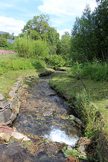
The border brook Pöhlwasser / Polava near Loučná pod Klínovcem . |
||
| Data | ||
| location | Saxony , Germany and Ústecký kraj , Czech Republic | |
| River system | Elbe | |
| Drain over | Zschopau → Freiberger Mulde → Mulde → Elbe → North Sea | |
| source | At Oberwiesenthal 50 ° 24 '23 " N , 12 ° 56' 33" E |
|
| Source height | about 1100 m above sea level NHN | |
| muzzle | In Wiesenbad in the Zschopau coordinates: 50 ° 37 '25 " N , 13 ° 3' 20" E 50 ° 37 '25 " N , 13 ° 3' 20" E |
|
| Mouth height | 415 m above sea level NHN | |
| Height difference | about 685 m
|
|
| Discharge at the Wiesa A Eo gauge : 86.3 km² Location: 1.1 km above the mouth |
NNQ (01/15/1963) MNQ 1961/2005 MQ 1961/2005 Mq 1961/2005 MHQ 1961/2005 HHQ (08/13/2002) |
90 l / s 363 l / s 1.71 m³ / s 19.8 l / (s km²) 14 m³ / s 65 m³ / s |
| Left tributaries | Hüttenbach, Schindelbach, Luxbach | |
| Right tributaries | Bílá Voda (white water), Conduppelbach | |
The Pöhlbach (Czech: Polava , in the upper reaches Hraniční potok ) is a right tributary of the Zschopau in Saxony and the Czech Republic .
course

It rises on the Schlauderwiese at an altitude of about 1100 meters in the Deutsche Zwicke, a Saxon border point on the Keilberg massif not far from the town of Gottesgab ( Boží Dar ).
The Pöhlbach flows as a Grenzbach through the Zechengrund near Oberwiesenthal , an old Saxon and Bohemian mining area .
On its banks are the mountain town of Oberwiesenthal and the German and Bohemian towns of Böhmisch Wiesenthal (Loučná pod Klínovcem), Unterwiesenthal , Hammerwerk Schlössel, Hammerunterwiesenthal , Lauxmühle (Výsada), Bohemian Hammer (České Hamry u Vejprt), precipitation , Neugeschrei ( Nové Zvolání ) Stahlberg , Bärenstein and Weipert ( Vejprty ).
At Lauxmühle, once a popular excursion destination, the white water (Bílá Voda) coming from Stolzenhain (Háj u Loučné) flows into the Pöhlbach.
Behind Weipert, at the now defunct Blechhammer, the Pöhlbach near Kühberg flows into Saxony. On the southern outskirts of the settlement Brettmühle belonging to Königswalde , the Conduppelbach flows from the right . The elongated village of Königswalde stretches along the river on both sides. Until the 19th century the brook formed an administrative border in the local area of Königswalde and divided the place into a western side (in the office of Schlettau or in the office of Grünhain ) and the eastern side, belonging to the council of the city of Annaberg (in the office of Wolkenstein ).
In the lower reaches of the Pöhlbach between the northern end of Königswalde via Geyersdorf and Plattenthal , the standard gauge Plattentalbahn ran in the 20th century . To the northwest of the Wiesenbad thermal baths , the Pöhlbach flows into the Zschopau near the Himmelmühle and the branch of the Plattentalbahn from the Annaberg-Buchholz and Bf-Flöha railway line .
Web links
Individual evidence
- ↑ Hydrological Handbook. (PDF; 637 kB) Part 3 - Main aquatic values. Free State of Saxony - State Office for Environment and Geology, p. 57 , accessed on December 25, 2017 .

