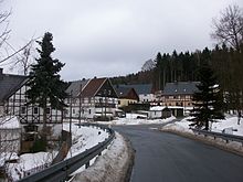
Brettmühle (Königswalde)
|
Board mill
Königswalde municipality
Coordinates: 50 ° 31 ′ 37 ″ N , 13 ° 3 ′ 25 ″ E
|
||
|---|---|---|
| Height : | 580 m | |
| Postal code : | 09471 | |
| Area code : | 03733 | |
|
Location of Brettmühle in Saxony |
||
Brettmühle is a settlement that belongs to the municipality of Königswalde in the Erzgebirgskreis (Free State of Saxony ).
geography
location
Brettmühle is located in the Middle Ore Mountains at the mouth of the Conduppelbach and the Pöhlbach . The settlement is separated from the settlement area of Königswalde in the south of the local area on "Bärensteiner Strasse" and north of the Annaberger Ratswald. Southeast of Brettmühle in the valley of the Conduppelbach lies the 737 m high "Gypsy Rock", which is the highest point in the municipality of Königswalde. The road leads through the village from Königswalde via Kühberg to Bärenstein .
Neighboring places
| Königswalde | ||

|
||
| Kühberg | Jöhstadt |
history
Around 1200, the district of Königswalde, located to the right of the Pöhlbach (east), was settled. In 1291 the eastern half of Königswalde was first mentioned in a document as "Lichtenhain". The place was under the rule of the Waldenburgs and came after their extinction in 1479 to the Electoral Saxon office of Selva . In 1512 Paul von Thumbshirn sold the eastern part of Königswalde to the city of Annaberg . The district has been called the council since then .
South of Königswalde, the board mill on the road to Bärenstein was built in 1536 by the city council of Annaberg . This sawmill was mentioned as early as 1558 in the Königswalder court book and operated as an important sawmill into the 20th century. In 1591 the sawmill was owned by the town of Annaberg. Every year around 8000 blocks of wood with a diameter of six cubits were processed into boards. The sawmill owned two neighboring farms with meadows and arable land that were leased. After the lease expired in 1850, the Annaberg City Council decided to divide the land into plots and lease it to various users. The vacant manor building was used as a restaurant after the licensing rights were granted in 1850. The most frequent guests at this time were lumbermen and forest workers. The restaurant is still in operation today. The sawmill in Brettmühle was in operation until 1967. Today only the foundation walls remain.
Since the union of the council side of Königswalde with the Brettmühle and the official side, the entire place belonged to the court office Annaberg from 1856 and from 1875 to the district administration Annaberg . As a result of the industrial development in the second half of the 19th century, a constant supply of drinking water in sufficient quantity and quality became necessary for the Annaberg area. For this purpose, the Annaberg raft ditch in the Annaberg Ratswald , which had been closed 40 years earlier, was piped in 1884 . Together with the water from the Conduppel Valley, which was held in 34 springs, the water was pumped through the waterworks on Bärensteiner Strasse, southwest of Brettmühle, built in 1889, over 120 meters in altitude up to the level of the raft ditch. The pump required for this was supplied by electricity from a turbine that was operated by water power from the mill ditch above. After the pump's output had to be increased several times, a second pump was added in 1934. In 1988, electric pumps replaced the two outdated turbine-driven piston press systems. Stadtwerke Annaberg has been the owner of the facility again since 1998. Between 2001 and 2003, the renovation of the waterworks and the listed repair of the hydropower plant with its machines from the Saxon machine factory in Chemnitz took place . The technical monument has been open to the public again since 2003 .
As a result of the second district reform in the GDR , Brettmühle came as part of the Königswalde community in 1952 to the Annaberg district in the Chemnitz district (renamed the Karl-Marx-Stadt district in 1953 ), which was continued as the Saxon district of Annaberg from 1990 and was added to the Erzgebirgskreis in 2008.
tourism
Brettmühle is affected by two supraregional and one regional hiking and cycling trails:
- Stage 7 of the Erzgebirge-Vogtland ridge trail from Statute to Bärenstein runs through the Conduppelbach valley and then towards Kühberg.
- The Stoneman Miriquidi , the most demanding mountain bike route in the Ore Mountains, runs on the Pöhlberg - Bärenstein section through the western district of Königswalde via Brettmühle to Kühberg.
- The Annaberger Landring (southwest part of the Südring) runs east of Königswalde, then through Brettmühle and then through the valley of the Conduppelbach to Jöhstadt .
Web links
- History of the sawmill in Brettmühle
- Height information from Brettmühle on a private website about topics from Königswalde
Individual evidence
- ^ Website of the municipality of Königswalde
- ↑ Historical map of Königswalde
- ↑ Website of the restaurant "Brettmühle"
- ^ The official authority Annaberg in the municipal register 1900
- ↑ The waterworks at Brettmühle on a private website about the town of Königswalde
- ^ Website of the Erzgebirge-Vogtland ridge trail
- ↑ The Stoneman Miriquidi on www.erzgebirge-tourismus.de ( Memento of the original from April 23, 2017 in the Internet Archive ) Info: The archive link was automatically inserted and not yet checked. Please check the original and archive link according to the instructions and then remove this notice.
- ^ Website of the Stoneman Miriquidi
- ^ Map of the Annaberger Landring


