
District of Annaberg
| coat of arms | Germany map |
|---|---|

|

Coordinates: 50 ° 35 ' N , 13 ° 0' E |
| Basic data (as of 2008) | |
| Existing period: | 1994-2008 |
| State : | Saxony |
| Administrative region : | Chemnitz |
| Administrative headquarters : | Annaberg-Buchholz |
| Area : | 438.17 km 2 |
| Residents: | 81,438 (Dec. 31, 2007) |
| Population density : | 186 inhabitants per km 2 |
| License plate : | ANA |
| Circle key : | 14 1 71 |
| Circle structure: | 17 municipalities |
| District Administrator : | Jürgen Förster (Citizens' Forum) |
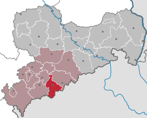
| Location of the district of Annaberg in Saxony | |
  |
|
The district of Annaberg was a district in the southwest of the Free State of Saxony . Neighboring districts were the Middle Ore Mountains in the east, the Czech administrative districts Karlsbad ( Karlovarský kraj ) and Aussig ( Ústecký kraj ) in the south, the Aue-Schwarzenberg district in the west and the Stollberg district in the northwest .
history
An early administrative unit on the territory of the later district was the Annaberg Mill Office . After silver finds on the Schreckenberg and the establishment of the "Neustadt am Schreckenberg" (renamed St. Annaberg in 1496, 1501), the Pöhlberg lordship previously existing in this area was dissolved in 1499 and converted into an office. Its seat was in the electoral manor mill on the Sehma. The mill gave the office its name. In 1553 the office was leased to the council of the city of Annaberg. Between 1590 and 1704 it was responsible for the three villages Frohnau , Geyersdorf and Kleinrückerswalde . In 1794, the Annaberg Mill Office was dissolved and its duties were transferred to the Selva Val Gardena justice office. However, various responsibilities remained on site until 1830. The mill office was part of the Erzgebirge district .
After the adoption of the Saxon constitution in 1831 and the resulting unification of the kingdom under constitutional law , an administrative reorganization of the national territory became necessary. In the course of this reform, the territory of what would later become the district of Annaberg was assigned to an administrative authority based in Forchheim . In 1871 the seat was moved to Annaberg . With the administrative reform of 1873/74 , the district administration Annaberg was formed within the territorial boundaries as they existed until 1952 and again between 1994 and 2008. In 1939 the name was changed to the district of Annaberg.
In 1952, as part of a territorial reform within the GDR , the district boundaries were also re-cut. The Annaberg district , which now belonged to the Karl-Marx-Stadt district , remained essentially in place, but had to include the communities of Ehrenfriedersdorf and Gelenau / Erzgeb in the north . , Herold , Jahnsbach and Thum cede to the newly created district of Zschopau . In a new district reform in 1994 , this change was reversed and the Annaberg district regained its historical shape.
As part of the administrative reform in Saxony , the districts of Annaberg, Aue-Schwarzenberg , Mittlerer Erzgebirgskreis and Stollberg merged on August 1st, 2008 to form the new Erzgebirgskreis .
politics
District Administrator
Wilfried Oettel ( CDU ) was from 1990 to 2001 , then Jürgen Förster ( Citizens' Forum Annaberg ) from 2001 to 2008 .
District council
After the local elections on June 13, 2004, the 50 seats in the district council were distributed among the individual parties as follows:
Political party |
Seats
|
| CDU |
24
|
| Citizens Forum |
13
|
| The left |
7th
|
| SPD |
3
|
| FDP |
3
|
economy
The district was characterized by medium-sized industry (especially wood and metal processing) - it had one of the highest densities of industrial jobs among employees subject to social insurance in Germany - and by tourism , through which the Silberstrasse ran .
Partnerships
The Annaberg district had the following partnerships:
- District of Nürnberger Land , Bavaria (since 1990)
- Kaohsiung County , Taiwan (since 1993)
cities and communes
(Population figures as of December 31, 2006)
|
|
License Plate
At the beginning of 1991 the district received the distinctive ANA . It was issued through July 31, 2008. It has been available in the Erzgebirgskreis since November 9, 2012 due to the license plate liberalization .
literature
- District Office Annaberg (Ed.): 125 years of the district of Annaberg 1874–1999. Administration through the ages. 1999
Annaberg | Aue-Schwarzenberg | Bautzen | Chemnitz | Chemnitz Land | Delitzsch | Chub | Dresden | Freiberg | Goerlitz | Hoyerswerda | Kamenz | Leipzig | Leipziger Land | Löbau-Zittau | Meissen | Middle Erzgebirgskreis | Mittweida | Muldentalkreis | Lower Silesian Upper Lusatia District | Plauen | Riesa-Großenhain | Saxon Switzerland | Stollberg | Torgau-Oschatz | Vogtlandkreis | Weißeritzkreis | Zwickau | Zwickau country