
District of Chemnitzer Land
| coat of arms | Germany map |
|---|---|

|

Coordinates: 50 ° 49 ' N , 12 ° 32' E |
| Basic data (as of 2008) | |
| Existing period: | 1994-2008 |
| State : | Saxony |
| Administrative region : | Chemnitz |
| Administrative headquarters : | Glauchau |
| Area : | 335.49 km 2 |
| Residents: | 131,431 (Dec. 31, 2007) |
| Population density : | 392 inhabitants per km 2 |
| License plate : | GC |
| Circle key : | 14 1 73 |
| Circle structure: | 15 municipalities |
| Address of the district administration: |
Gerhart-Hauptmann-Weg 2 08371 Glauchau |
| District Administrator : | Christoph Scheurer ( CDU ) |
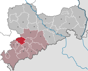
| Location of the Chemnitzer Land district in Saxony | |
  |
|
The district of Chemnitzer Land was a district in the west of the Free State of Saxony that existed from 1994 to 2008 . The population density was just under 400 inhabitants per km². Thus, the district was Chemnitzer Land of the most densely populated county in the former East Germany and surpassed in population density, various county-level cities of the East, such as Brandenburg an der Havel .
geography
.jpg)
The former district area lies in the Erzgebirge foothills. Neighboring districts were the Thuringian district of Altenburger Land in the north, the district of Mittweida in the northeast, the independent city of Chemnitz in the east, the district of Stollberg in the southeast and the district of Zwickauer Land and the independent city of Zwickau in the southwest .
The district area has the following bodies of water: the Zwickauer Mulde river and the Glauchau and Oberwald reservoirs. Forest areas: Rabensteiner Wald, Rümpf- and Oberwald. The highest point is the Langenberger Höhe (484 m).
history
The district was created on August 1, 1994 by amalgamating the Glauchau and Hohenstein-Ernstthal districts and parts of the Chemnitz district .
In the course of the Saxon district reform , the district of Chemnitzer Land was merged with the district of Zwickauer Land and the independent city of Zwickau to form the new district of Zwickau with effect from August 1, 2008. A Z is used as the license plate number .
politics
The last district administrator in the Chemnitzer Land district was Christoph Scheurer (CDU).
District council
The 58 seats in the district council were distributed among the individual parties as follows:
Political party |
Seats
|
| CDU |
24
|
| PDS |
12
|
| SPD |
7th
|
| Independent list |
5
|
| FDP |
4th
|
| FWV |
3
|
| GREEN |
2
|
| NPD |
1
|
Economy and Infrastructure
economy
The economy of the district was mainly shaped by machine and vehicle construction. The following companies belonged to this area: Continental AG , Hella-Behr , Samvardhana Motherson Peguform , SEW-Eurodrive , Weigl Antriebstechnik and BMG .
traffic
- Federal motorways : A 4 , A 72
- Federal highways : B 180 , B 173 , B 175 , B 93
education
In the district there was a study academy ( BA-Glauchau ) as well as several vocational schools and high schools. There were also various universities in the neighboring cities of Chemnitz and Zwickau.
cities and communes
(Population figures as of December 31, 2006)
|
|
- Administrative community Limbach-Oberfrohna with the member communities Limbach-Oberfrohna and Niederfrohna
- Administrative community Meerane with the member communities Meerane and Schönberg
- Administrative community around the Auersberg with the member communities Bernsdorf, Lichtenstein (VG headquarters) and St. Egidien
- Administrative community Waldenburg with the member communities Oberwiera, Remse and Waldenburg
License Plate
On August 1, 1994, the district was assigned the GC , which has been valid since January 1, 1991 for the Glauchau district. It was issued through July 31, 2008. It has been available in the Zwickau district since November 9, 2012.
Annaberg | Aue-Schwarzenberg | Bautzen | Chemnitz | Chemnitz Land | Delitzsch | Chub | Dresden | Freiberg | Goerlitz | Hoyerswerda | Kamenz | Leipzig | Leipziger Land | Löbau-Zittau | Meissen | Middle Erzgebirgskreis | Mittweida | Muldentalkreis | Lower Silesian Upper Lusatia District | Plauen | Riesa-Großenhain | Saxon Switzerland | Stollberg | Torgau-Oschatz | Vogtlandkreis | Weißeritzkreis | Zwickau | Zwickau country