
Löbau-Zittau district
| coat of arms | Germany map |
|---|---|

|

|
| Basic data (as of 2008) | |
| Existing period: | 1994-2008 |
| State : | Saxony |
| Administrative region : | Dresden |
| Administrative headquarters : | Zittau |
| Area : | 698.54 km 2 |
| Residents: | 138,772 (Dec 31, 2007) |
| Population density : | 199 inhabitants per km 2 |
| License plate : | ZI |
| Circle key : | 14 2 86 |
| Circle structure: | 32 municipalities |
| Address of the district administration: |
Hochwaldstrasse 29 02763 Zittau |
| District Administrator : | Günter Vallentin ( CDU ) |
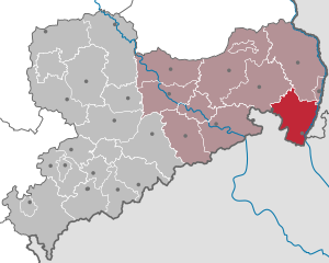
| Location of the district of Löbau-Zittau in Saxony | |
  |
|
The district of Löbau-Zittau (until December 31, 1994 Sächsischer Oberlausitzkreis ) was from 1994 to 2008 a district in the far east of the Free State of Saxony . Neighboring districts were the Lower Silesian Upper Lusatia District and the independent city of Görlitz in the north, and the Bautzen district in the west . The district bordered the Republic of Poland ( Lower Silesian Voivodeship ) to the east and the Czech Republic to the south . The district was a member of the Neisse Euroregion . In the Saxon district reform of 2008 , it was integrated into the newly formed district of Görlitz .
geography
Important rivers in the former district are the Lausitzer Neisse , Mandau and Löbauer Wasser . The headwaters of the Spree are also located there .
As the German part of the Lusatian Mountains , the Zittau Mountains are located in the southern part of the former district. The highest mountains were the Lausche ( 793 m ) and the Hochwald ( 749 m ).
See also: List of Landscapes in Saxony , List of Waters in Saxony , Natural Areas in Saxony
history
At the end of the 12th and beginning of the 13th century, German peasant settlers invaded the Slavic area. Village complexes were usually created as Waldhufendörfer . In 1346 the cities of Bautzen , Kamenz , Lauban , Löbau , Görlitz and Zittau merged to form the Upper Lusatian Six- Cities League , whose convent town became Löbau.
Since 1346 the district has belonged to the Kingdom of Bohemia within the Margraviate of Upper Lusatia . Almost 300 years later it passed into the territory of the Electorate of Saxony in 1635 .
In the 16th century, new settlements were established as a result of the rapid boom in linen weaving. Zittau was one of the richest landowners in southern Upper Lusatia.
In 1722, Herrnhut was founded . Count Zinzendorf made it possible for Bohemian and Moravian religious refugees to settle. In the 18th and 19th centuries there were also new village developments in other places as a result of the influx of Bohemian religious refugees.
In the middle of the 19th century, home weaving was gradually replaced by large-scale industrial production. Settlements grew again and Zittau developed into the industrial center of Upper Lusatia. The construction of the Görlitz – Zittau, Zittau – Reichenberg (Bohemia) and the Zittau – Oybin / Jonsdorf narrow-gauge railway lines took this into account.
On the Löbauer Berg , the King Friedrich August Tower was built in 1854, with its cast iron construction that is unique in Europe . It was to become the coat of arms of the Löbau district almost 150 years later .
Towards the end of the century, in 1888, the long history of vehicle construction in Zittau began.
By the beginning of the 20th century, industrial production had driven the home industry into insignificance. There was a concentration of population in metropolitan areas with strong economic power as a result of the technical and industrial revolution.
The district was largely spared from destruction towards the end of the Second World War . Instead, the border was drawn along the Lusatian Neisse and the German population was expelled from the areas to the east of it.
On July 25, 1952 , the districts of the GDR were reorganized, from which the Löbau and Zittau districts also emerged .
During the fall of the Wall , a restructuring process began, especially in the economy. There was job cuts, but also infrastructural expansion.
With the district reform in 1994 , the districts of Löbau and Zittau as well as the places of the proper district of the district of Görlitz were initially united with Zittau as the district seat under the name Sächsischer Oberlausitzkreis , whose name is similar to that of the Lower Silesian Oberlausitzkreis. Similar to the district of Westlausitz-Dresdner Land , the name was also rejected in the Saxon Upper Lusatia district, which resulted in the name change to the district of Löbau-Zittau on January 1, 1995.
In the course of the municipal reform in 1999, the number of municipalities was reduced by eight through incorporations and amalgamations.
As a result of another district reform , the district of Löbau-Zittau, the city of Görlitz and the Lower Silesian Upper Lusatia district were merged to form the district of Görlitz with Görlitz as the seat of the district on August 1, 2008 - exactly 14 years after the district was founded.
On September 23, 2008 the district received the title “ Place of Diversity ” awarded by the Federal Government .
→ For the history, see also: Oberlausitz
coat of arms
A competition was announced in 1994 to find a coat of arms, from which a proposal by Löbauer Dieter Strahl emerged as the winner in 1995. With 44 votes in favor, 6 against and 6 abstentions, the district council decided on March 27, 1996 to use the coat of arms in the Löbau-Zittau district. This coat of arms was approved by the Dresden Regional Council on May 29, 1996 .
Two towers in blue with a golden bar border behind a framework house (left town hall tower of Löbau, right town hall tower of Zittau), the buildings each golden with silver architectural parts.
- meaning
Since the former district area is part of Upper Lusatia, the district's coat of arms was based on the colors blue and yellow. The half-timbered house is a typical residential and work building in the southern part of Upper Lusatia; the towers are modeled on the town hall towers of the two namesake cities: left (heraldic right) the Löbauer town hall tower , right (heraldic left) the Zittau town hall tower .
traffic
Federal highways
- Federal road 6 : Bautzen - Löbau - Görlitz
- Bundesstrasse 96 : Zittau - Ebersbach / Sa. - Oppach- Bautzen
- Federal road 98 : Oppach– Bischofswerda
- Bundesstrasse 99 : Zittau – Görlitz
- Bundesstrasse 178 : Zittau – Herrnhut –Löbau
Border crossings
for trucks:
- Neugersdorf / bypass road S 148 - Rumburg ( Rumburk ) (CZ)
for cars:
- Ebersbach / Sa. - Georgswalde ( Jiříkov ) (CZ)
- Großschönau - Warnsdorf (Varnsdorf) (CZ)
- Lückendorf - Petrovice (Petersdorf) (CZ)
- Neugersdorf / Hauptstraße - Georgswalde (Jiříkov) and Rumburg (Rumburk)
- Neugersdorf / Rudolf-Breitscheid-Strasse - Georgswalde (Jiříkov)
- Seifhennersdorf - Warnsdorf ( Varnsdorf ) (CZ)
- Seifhennersdorf - Rumburg ( Rumburk ) (CZ)
- Zittau / Friedensstraße - Poritsch ( Porajów ) (PL) with continuation to Grottau ( Hrádek nad Nisou ) (CZ)
- Zittau / Chopinstrasse - Kleinschönau ( Sieniawka ) (PL)
- Zittau / Bundesstraße 178 - Kleinschönau (Sieniawka) (PL) with continuation to Oberullersdorf ( Kopaczów ) - Ullersdorf ( Oldřichov na Hranicích ) (CZ) (planned)
Attractions
- Schminke house (architect Hans Scharoun ) in Löbau
- St. Marienthal Monastery in Ostritz
- Medieval Lenten cloths in the Kreuzkirche Zittau
- Marstall (salt house) Zittau
- Viaducts in Obercunnersdorf and Zittau
- Cast iron tower on the Löbauer Berg ( Löbau )
- Oybin castle ruins
- Zinzendorfplatz and Ethnological Museum in Herrnhut
- Riding house in Neusalza-Spremberg
- German Damask and Terrycloth Museum in Großschönau
- 3 Spree springs (Kottmar, Ebersbach / Sa. And Neugersdorf )
- Post windmills Kottmarsdorf and Oderwitz
- Half-timbered houses as a typical regional construction
- Zittau Mountains
- Lusatian highlands
Colleges
- University of Applied Sciences Zittau / Görlitz (University of Applied Sciences)
- Neisse University (university cooperation in the Euroregion Neisse )
- International University Institute Zittau (University Institution of the State of Saxony)
Partnerships
The district maintained the following partnership relationships:
- Neckar-Odenwald district , Baden-Württemberg (since 1990)
- District of Göppingen , Baden-Württemberg (since 1991)
- Lubań County , Poland (since 2000)
politics
The last district administrator in the Löbau-Zittau district was Günter Vallentin (CDU).
District council
The 62 seats in the last district assembly were distributed among the individual parties as follows:
Political party |
Seats
|
| CDU |
27
|
| LEFT |
15th
|
| SPD |
7th
|
| FDP |
6th
|
| DSU |
4th
|
| GREEN |
3
|
cities and communes
(Population figures as of December 31, 2006)
|
|
License Plate
On August 1, 1994, the district was assigned the ZI distinctive sign , which has been valid for the Zittau district since January 1, 1991 . It was issued through July 31, 2008. It has been available again in the Görlitz district since November 9, 2012.
Individual evidence
- ↑ Information for 14 0 86 district Sächsischer Oberlausitzkreis in the regional register Saxony of the statistical office
- ^ Eckhart Leisering: Coat of arms of the independent cities and districts in the Free State of Saxony . mdv, Mitteldeutscher Verlag, Halle / Saale 2000, ISBN 3-89812-069-4 , p. 69 ff .
- ↑ District election 2004: Eligible voters, voters, invalid and valid ballot papers as well as the distribution of votes in the elections on June 13, 2004 and June 13, 1999 in the Löbau-Zittau district. State Statistical Office of the Free State of Saxony , accessed on December 4, 2014 .
Annaberg | Aue-Schwarzenberg | Bautzen | Chemnitz | Chemnitz Land | Delitzsch | Chub | Dresden | Freiberg | Goerlitz | Hoyerswerda | Kamenz | Leipzig | Leipziger Land | Löbau-Zittau | Meissen | Middle Erzgebirgskreis | Mittweida | Muldentalkreis | Lower Silesian Upper Lusatia District | Plauen | Riesa-Großenhain | Saxon Switzerland | Stollberg | Torgau-Oschatz | Vogtlandkreis | Weißeritzkreis | Zwickau | Zwickau country