
Jonsdorf
| coat of arms | Germany map | |
|---|---|---|

|
Coordinates: 50 ° 51 ' N , 14 ° 42' E |
|
| Basic data | ||
| State : | Saxony | |
| County : | Goerlitz | |
| Management Community : | Olbersdorf | |
| Height : | 442 m above sea level NHN | |
| Area : | 9.03 km 2 | |
| Residents: | 1548 (Dec. 31, 2019) | |
| Population density : | 171 inhabitants per km 2 | |
| Postal code : | 02796 | |
| Area code : | 035844 | |
| License plate : | GR, LÖB, NOL, NY, WSW, ZI | |
| Community key : | 14 6 26 210 | |
| Address of the municipal administration: |
Auf der Heide 1 02796 Jonsdorf health resort |
|
| Website : | ||
| Mayor : | Kati Wenzel (Free Voters Citizens' Forum Jonsdorf eV) | |
| Location of the community of Jonsdorf in the district of Görlitz | ||
  |
||

Jonsdorf is a state-approved climatic health resort in the Zittau Mountains . The Saxon community in the district of Görlitz belongs to the administrative community of Olbersdorf .
geography

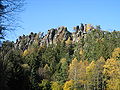
Jonsdorf lies in the basins of the Grundbach and the Pochebach in the Zittau Mountains, right on the border with Northern Bohemia ( Czech Republic ). The place is framed by several mountains such as the Buchberg and the Jonsberg . In the southeast is the protected Jonsdorf rock town and the Nonnenfelsen rock chain.
history

Jonsdorf was first mentioned in a document in 1539. The Cölestin monastery in Oybin sold properties to ten settlers. In 1574, Maximilian II sold the Oybiner property to the city of Zittau and Jonsdorf became a council village. After the sons of the local judge Hans Richter had discovered in 1560 that the sandstone found south of the village was suitable for the production of millstones , Hieronymus Richter leased the first quarry from the city of Zittau in 1580. In 1667, the city council of Zittau am Pochebach decided to designate further building sites between Jonsdorf and Waltersdorf , which resulted in Neu-Jonsdorf. In 1731, the heather between Alt- and Neu-Jonsdorf was cut down and the area built on, so that both villages grew together. In the same year, after a year of construction, the church in Alt-Jonsdorf was completed.
In the second half of the 18th century, linen weaving was of great economic importance in Jonsdorf.

From 1840 the structural design of the village began to change. Instead of the previous framework construction , the houses were built as solid structures. Villa-like buildings were also built as country residences for urban citizens.
In 1841 the tourist development of the village began. Karl Linke opened a cold water sanatorium . The beginning of the spa business promoted tourism . In 1890 the Zittau narrow-gauge railway to Jonsdorf was inaugurated .
After more than 300 years, the quarrying of millstones in Jonsdorf ended in 1917.
At the end of the Second World War , Jonsdorf took in many refugees who had been driven from their homeland, especially from the neighboring Bohemian villages.
In 1952 and 1953, the national construction organization (NAW) created the ice rink and the forest stage. In 1956 the Bertsdorf district of Hänischmühe Jonsdorf was incorporated. A new school was built at the Hieronymus Stone in 1984.
The Arena leisure and ice sports center was inaugurated in 1996. In the same year, work began on redesigning the spa park, which continued until 1997. The butterfly house opened in 2004 .
Population development
| year | Residents |
| 1553 | 22 gardeners |
| 1777 | 25 gardeners, 81 cottagers, 3 devastation |
| 1834 | 1688 |
| 1871 | 1539 |
| 1890 | 1545 |
| 1910 | 1426 |
| 1925 | 1717 |
| 1939 | 1857 |
| 1946 | 2247 |
| 1950 | 2335 |
| 1964 | 2327 |
| 1990 | 1857 |
| 2000 | 2026 |
| 2007 | 1814 |
| 2009 | 1782 |
| 2012 | 1655 |
| 2013 | 1639 |
Place name forms
1539: Yansdorff, 1553: Yansdorff, 1565: Janßdorff, 1721: Jonnßdorff, 1791: Johnsdorf, Alt-, 1875: Johnsdorf b. Zittau (old and new)
politics
Municipal council
Since the municipal council election on May 26, 2019 , the 12 seats of the municipal council have been distributed among the individual groups as follows:
- Citizens' Forum Free Voters Jonsdorf eV (BF): 12 seats
Administrative affiliation
1777: Görlitzer Kreis, 1843: Regional Court District Löbau, 1856: Judicial Office Zittau, 1875: Amtshauptmannschaft Zittau, 1952: District Zittau, 1994: District Löbau-Zittau, 2008: District Görlitz
Culture and sights


The cultural monuments are recorded in the list of cultural monuments in Jonsdorf .
- Spa gardens
- Kurpark pavilion
- Butterfly house
- Waldbühne
- Upper Lusatian cottage garden
- Oberlausitzer Weberstube
- numerous half-timbered houses
- Zittau narrow-gauge railway
- Protestant church (with works by the woodcut artist Hellmuth Muntschick )
- Quarry forge
- Show workshop millstone quarries
- Observatory
- Folk play art "Thalia" Jonsdorf (Upper Lusatian dialect group)
- Gondola pond
- War memorial
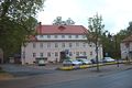
Jonsdorf municipal office

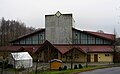
Jonsdorf station
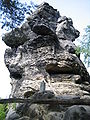
The nuns rocks
The Falkenstein on the Czech-German border
Sparkassen Arena


Natural monuments


- Nuns rock
- Millstone quarries
- Small organ (sintered sandstone pillars)
- Jonsdorf rock town
- White stone
- Falkenstein
- Jerome Stone
Sports
- Leisure and ice sports center (Sparkassen Arena)
- Mountain bath
In Jonsdorf played the ice hockey club EHC Jonsdorfer Falken , whose first team participated in the league until 2013/14 .
traffic
Jonsdorf is away from the major roads. The place has a railway connection with the Zittau narrow-gauge railway, which is used almost exclusively for tourism. The former train station was converted into a restaurant and guesthouse. The place has two border crossings open to the Czech Republic for pedestrians and cyclists, one of them to Mařenice - Dolní Světlá (Großmergthal - Niederlichtenwalde). Since December 20, 2011, after the expansion of the K 8651 road, a car border crossing into the Bohemian Valy has been available.
Personalities
- The founder of the place was the shepherd Jonas, a monk from the Celestine monastery on the mountain Oybin
Sons and daughters of the church
- Christian Adolf Pescheck (1787–1859), theologian and historian
- August Hoffmann (1802–1878), businessman, freight forwarder and member of the Frankfurt National Assembly
literature
- Cornelius Gurlitt : Jonsdorf. In: Descriptive representation of the older architectural and art monuments of the Kingdom of Saxony. 29. Issue: Amtshauptmannschaft Zittau (Land) . CC Meinhold, Dresden 1906, p. 85.
Web links
- Jonsdorf butterfly house
- Neujonsdorf in the Digital Historical Directory of Saxony
Individual evidence
- ↑ Population of the Free State of Saxony by municipalities on December 31, 2019 ( help on this ).
- ^ Jonsdorf in the Digital Historical Directory of Saxony
- ↑ Results of the 2019 municipal council elections

Bad Muskau (Mužakow) | Beiersdorf | Bernstadt ad Eigen | Bertsdorf-Hörnitz | Boxberg / OL (Hamor) | Dürrhennersdorf | Ebersbach-Neugersdorf | Gablenz (Jabłońc) | Goerlitz | Groß Düben (Dźěwin) | Großschönau | Großschweidnitz | Chickens | Hainewalde | Herrnhut | Hohendubrau (Wysoka Dubrawa) | Horka | Jonsdorf | Kodersdorf | Königshain | Kottmar | Krauschwitz (Krušwica) | Kreba-Neudorf (Chrjebja-Nowa Wjes) | Lawalde | Leutersdorf | Löbau | Markersdorf | Mittelherwigsdorf | Mücka (Mikow) | Neißeaue | Neusalza-Spremberg | Niesky | Oderwitz | Olbersdorf | Oppach | Ostritz | Oybin | Quitzdorf am See | Reichenbach / OL | Rietschen (Rěčicy) | Rosenbach | Rothenburg / OL | Loop (slepo) | Schönau-Berzdorf ad Eigen | Schönbach | Schöpstal | Seifhennersdorf | Trebendorf (Trjebin) | Vierkirchen | Forest hooves | White chisel (Wuskidź) | White water (Běła Woda) | Zittau