
Gablenz (Upper Lusatia)
| coat of arms | Germany map | |
|---|---|---|
.png)
|
Coordinates: 51 ° 32 ' N , 14 ° 40' E |
|
| Basic data | ||
| State : | Saxony | |
| County : | Goerlitz | |
| Management Community : | Bad Muskau | |
| Height : | 138 m above sea level NHN | |
| Area : | 14.74 km 2 | |
| Residents: | 1595 (Dec. 31, 2019) | |
| Population density : | 108 inhabitants per km 2 | |
| Postal code : | 02953 | |
| Area code : | 03576 | |
| License plate : | GR, LÖB, NOL, NY, WSW, ZI | |
| Community key : | 14 6 26 100 | |
| Community structure: | 2 parts of the community | |
| Association administration address: | Berliner Strasse 47 02953 Bad Muskau |
|
| Mayor : | Dietmar Noack ( CDU ) | |
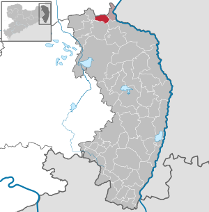
| Location of the municipality of Gablenz in the district of Görlitz | ||
  |
||

Gablenz , Upper Sorbian , is a municipality in the Görlitz district in Saxony . It is a member of the Bad Muskau administrative community and is located in the Sorbian settlement area in Upper Lusatia .
Geography and traffic
The municipality of Gablenz is located in the northwestern part of the district, about 5 km northeast of Weißwasser . The B 156 runs about 2 km southeast of the village. The B 115 runs about 6 km away. The community is located in the forest and pond area of the Muskauer Heide . The next train stations are in Weißwasser and in the western loop on the Berlin – Görlitz railway line .
Neighboring communities
Jämlitz-Klein Düben (N) in the Brandenburg district of Spree-Neiße, Bad Muskau (O), Krauschwitz (SO), Weißwasser (S) and Groß Düben (W) border the municipality of Gablenz clockwise .
Local division
The municipality consists of the municipality parts Gablenz ( Jabłońc ) with about 1400 inhabitants and Kromlau ( Kromola ) with about 400 inhabitants. The Wossinka settlement directly on the Brandenburg state border also belongs to the Gablenz district.
history
Local history
Gablenz was first mentioned in a document in 1268 in an Upper Lusatian border document, in which other places such as the town of Rothenburg / Upper Lusatia were first mentioned.
For centuries, Gablenz was shaped by the neighboring town of Muskau and the local rulership of Muskau , to which Gablenz had belonged since the 16th century at the latest. The Silesian exclave Kromlau on the border between the margravate Oberlausitz and Niederlausitz, however, never belonged to the rulership of Muskau. Historically, the place was more connected to the neighboring places in Niederlausitz, although Kromlau is a parish in Gablenz.
When the eastern half of Upper Lusatia had to be ceded to Prussia as a result of the Congress of Vienna in 1815, Gablenz was incorporated into the Rothenburg district (Ob. Laus.) The following year . Since 1874, the rural community to belong District Muskau I, which was divided into the new districts Keula and Lugknitz 1,933th After the municipality of Lugknitz was divided up and incorporated into municipalities in 1940, the associated administrative district was renamed "Amtsgebiet Gablenz". Until 1945 the communities Gablenz and Köbeln and the Burglehn Muskau were located in it.
Towards the end of the 19th century, the majority of Gablenzers were monolingual Sorbian and spoke the Muskau transitional dialect . Arnošt Muka had a total of 793 inhabitants in 1884/85, 755 of them Sorbs and 38 Germans. He reported that although German pastors had taken up their duties in the parish in the previous years, the language conditions in the parish meant that they were forced to learn Sorbian in order to be able to communicate with their parishioners.
When in July 1952 the states in the GDR were abolished in favor of the new districts and the districts were reorganized, Kromlau was assigned to this district when the Weisswasser district was founded . From then on, the place belonged to the same administrative unit as Gablenz.
On January 1, 1999, the communities Kromlau and Gablenz merged.
Origin of name
According to Meschgang, the Sorbian name Jabłońc means 'branch on the apple tree'. It was mentioned in 1268 as Gabelenz, 1499 as Gabelencz and 1767 as Jabłonz (see Jablonec ).
The Kromlau name could either have originated from the personal name Kromola or go back to the Old Sorbian kromoła for 'quarrel' or 'dispute'. It was mentioned in 1542 as Kromola, Krommolau, Krumla and in 1843 as Kromoła.
politics
The municipality council of the municipality of Gablenz consists of 12 municipal councils, which are distributed as follows (for comparison the results of the previous elections):
| Political party | Seats on the local council |
Election 2014 | Election 2009 | Election 2019 |
| CDU | 6th | 53.0% | 42.5% | 43.9% |
| SPD | 0 | 12.1% | 17.4% | 5.9% |
| The left | 1 | 14.9% | 14.8% | 8.0% |
| UWVGK | 2 | 17.1% | 11.9% | 15.3% |
| Free voters | 0 | 2.9% | 10.3% | nk |
| Voter Association We for you | 3 | nk | nk | 26.9% |
Attractions
→ see also: List of cultural monuments in Gablenz

The azalea and rhododendron park Kromlau , in which the Kromlau Castle and the Kavaliershaus, also known as the Schweizerhaus, are located, is of supraregional importance .

The village church in Gablenz was rebuilt in 1759 in a late Baroque style and with the support of the Muskau landlord. For the 150th anniversary of the parish, Pastor Adolf Aisch wrote the history of the parish of Gablenz and its villages (Gablenz, Jämlitz , Klein Düben and Kromlau ). On the occasion of the 250-year consecration of the church, the church was named Trinity Church.
The Bartelshof with a park is located near the church. A scrap wood house in the yard is a beehive that is more than 130 years old.
freetime and sports
The Universum sports club in the town center offers numerous courses, sauna and massage. The Gablenzer Freizeit offers bowling alleys, mini golf, badminton, squash; There is also a swimming lake with a campsite and bungalows in Kromlau and two riding stables.
Regular events
In February the Zampern takes place with the subsequent Zamperball. This will be followed by witch burning and maypole on April 30th . At Whitsun, the Park and Blossom Festival in Kromlauer Park is one of the nationally known park festivals that has several thousand visitors every year. In the further course of the year there is the club festival of the Gablenz football club and a street football tournament in which Gablenz streets or settlements compete against each other. On the Day of German Unity on October 3, an Oktoberfest with an Oktoberfest and kite festival, soccer and volleyball tournament is held.
Personalities
- Kurt Lange (1923–1989), Lieutenant General of the NVA
- Manfred Scheler (1929–2014), politician (SED), Chairman of the Dresden District Council
- Tino Chrupalla (* 1975), politician (AfD)
Sources and further reading
literature
- From the Muskauer Heide to the Rotstein. Home book of the Lower Silesian Upper Lusatia District . Lusatia Verlag , Bautzen 2006, ISBN 978-3-929091-96-0 .
- Adolf Aisch : History of the Protestant Parish Gablenz O.-L. Görlitz 1909 ( digitized version of the SLUB Dresden ).
Footnotes
- ↑ Population of the Free State of Saxony by municipalities on December 31, 2019 ( help on this ).
- ^ Gablenz in the Digital Historical Directory of Saxony
- ↑ Ernst Tschernik: The development of the Sorbian population. Akademie-Verlag, Berlin 1954, p. 117
- ↑ Arnost Muka: Pućowanja po Serbach. Nakład Domowiny, Budyšin 1957, pp. 79f.
- ↑ StBA: Changes in the municipalities in Germany, see 1999
- ^ Jan Meschgang : The place names of Upper Lusatia . 2nd Edition. Domowina-Verlag, Bautzen 1979 (edited by Ernst Eichler ).
- ↑ Results of the 2014 municipal council elections in Gablenz at www.statistik.sachsen.de. State Statistical Office of the Free State of Saxony , accessed on May 28, 2014 .
- ↑ "% 23tab vote distribution": 1% 7D results of the municipal council election 2019 in Gablenz on www.wahlen.sachsen.de. State Statistical Office of the Free State of Saxony, accessed on March 24, 2020 .
Web links

Bad Muskau (Mužakow) | Beiersdorf | Bernstadt ad Eigen | Bertsdorf-Hörnitz | Boxberg / OL (Hamor) | Dürrhennersdorf | Ebersbach-Neugersdorf | Gablenz (Jabłońc) | Goerlitz | Groß Düben (Dźěwin) | Großschönau | Großschweidnitz | Chickens | Hainewalde | Herrnhut | Hohendubrau (Wysoka Dubrawa) | Horka | Jonsdorf | Kodersdorf | Königshain | Kottmar | Krauschwitz (Krušwica) | Kreba-Neudorf (Chrjebja-Nowa Wjes) | Lawalde | Leutersdorf | Löbau | Markersdorf | Mittelherwigsdorf | Mücka (Mikow) | Neißeaue | Neusalza-Spremberg | Niesky | Oderwitz | Olbersdorf | Oppach | Ostritz | Oybin | Quitzdorf am See | Reichenbach / OL | Rietschen (Rěčicy) | Rosenbach | Rothenburg / OL | Loop (slepo) | Schönau-Berzdorf ad Eigen | Schönbach | Schöpstal | Seifhennersdorf | Trebendorf (Trjebin) | Vierkirchen | Forest hooves | White chisel (Wuskidź) | White water (Běła Woda) | Zittau