Markersdorf (Saxony)
| coat of arms | Germany map | |
|---|---|---|

|
Coordinates: 51 ° 9 ' N , 14 ° 53' E |
|
| Basic data | ||
| State : | Saxony | |
| County : | Goerlitz | |
| Height : | 242 m above sea level NHN | |
| Area : | 62.54 km 2 | |
| Residents: | 3901 (Dec. 31, 2019) | |
| Population density : | 62 inhabitants per km 2 | |
| Postal code : | 02829 | |
| Area code : | 035829 | |
| License plate : | GR, LÖB, NOL, NY, WSW, ZI | |
| Community key : | 14 6 26 300 | |
| Community structure: | 7 districts | |
| Address of the municipal administration: |
Kirchstrasse 3 02829 Markersdorf |
|
| Website : | ||
| Mayor : | Thomas Knack | |
| Location of the community of Markersdorf in the district of Görlitz | ||
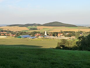
Markersdorf ( Upper Sorbian Markoćicy ) is a Saxon municipality in the district of Görlitz .
geography
The community of Markersdorf is located in the central part of the district. It borders the district town of Görlitz in the east and lies below the state crown , which dominates the landscape. The White Schöps flows through Markersdorf .
geology
All of the villages in the municipality of Markersdorf are located in eastern Upper Lusatia , the surface of which consists of gravel terraces , a granite base and the protruding basalt or phonolite dome . The fertile floodplains are often embedded in the granite. The landscape is shaped by the course of the Weißen Schöps and its course from south to north. In the same direction, a ridge to the east forms the watershed . They separate the catchment areas of the Neisse and the Spree . This watershed runs over the Jauernicker Mountains , the Landeskrone , the airfield in Görlitz and the Galgenberge near Ludwigsdorf . The fighter mountains with a height of 405 m as well as the granite Königshain mountains border the river area of the Weißen Schöps. Remnants of a brickworks behind the Markersdorf railway line indicate that there were raw materials here, and in some cases still exist, which made brickworks possible. In Markersdorf in particular, there were stocks of clay and decomposed greywacke . There were several bricks around Görlitz, one of them in Markersdorf. From 1768 to 1800 iron was mined from three shafts in Markersdorf. The production was stopped after 12 years, because the iron content was quite low and the transport of the ore to the smelter in the heath with the local charcoal was too far.
Climate and soil
Markersdorf with its districts is located in the humid zone, which has a pronounced transitional climate. The annual mean temperature fluctuates around 8 ° C. The January mean is only slightly below 0 ° C and the July mean is around 18 ° C. The long-term average rainfall is 700 mm. The normal value of the air pressure is 742 mm at an altitude of 200 m above sea level. The winters are somewhat milder than to be expected according to the latitude (51.9 AD) ( Sakhalin , Irkutsk , Kiev are located at the same latitude ). The wind directions predominate mostly from west-southwest and northwest, from which the mild winters are determined. The soil was formed from weathering due to the temperature fluctuations in this climate. The amounts of acid present, plants, animals and finally humans play an essential role. So is the underground z. Partly already loosened granite discolored because of the iron components. The groundwater contains iron and manganese. Unfortunately, through intensive fertilization, harmful nitrates got into the water (nitrogen).
Community structure
Today's large community of Markersdorf came into being on January 1, 1994, when the communities of Markersdorf, Deutsch-Paulsdorf ( Sorbian : Němske Pawlice ), Friedersdorf , Gersdorf , Holtendorf , Jauernick-Buschbach ( Jawernik-Nechow ) and Pfaffendorf merged as part of the Saxon community reform. The former seven municipalities continue to exist as equal districts within the municipality, which is to be symbolized by the coat of arms - seven identical leaves on a tree.
history
Human traces can be found in the vicinity of Markersdorf for the Middle Stone Age, from about 12000 to 3000 BC. Chr., Prove. During excavations and field work, flint pieces, club heads and cylinder axes were found. The finds concentrate on the places Niesky, Weißwasser and Görlitz, i.e. places that are close to Markersdorf.
In 1360 the community of Markersdorf was first mentioned in a deed of foundation in the Görlitz town register. Markersdorf was probably named after the town's founder "Markwart".
The first church is said to have been built in Jauernick as early as 980, and the village must have developed into a place of pilgrimage . A change of ownership took place around the middle of the 13th century, as the Bohemian King Wenzel I (Premysl), who was then sovereign of Upper Lusatia, transferred Jauernick to the St. Marienthal monastery on June 15, 1242 . Hertwicus de Sprewemberch acted as one of the royal guarantors to certify the transfer . Markersdorf itself was created around 1150 as a Waldhufendorf . The place was ruled by a Mr. von Gersdorf in the oldest known time. On February 6, 1394, his son Jonas sold the half of the village north of the White Schöps to the abbess Euphemia of the Marienthal monastery. This part of the village was then named monastery part and remained in the possession of the Zinserzienser monastery until 1856. Jonas also sold another piece of the village to the Jakobshospital in Görlitz, which at that time was located approximately at the height of Wilhelmsplatz in Görlitz. The remainder of the village north of the Weißen Schöps was later sold to the town council of Görlitz by the knight of Gersdorf. The merchant Barthel Hirschberg again acquired the village from the city of Görlitz in 1451 for 436 Görlitz marks. The landlords changed through purchases and sales, which always brought a lucrative profit.
The landlords included:
- 1394 Marienthal Monastery
- 1430 Nickel from Gersdorf
- 1450 Friedrich Rossendorf (councilor in Görlitz)
- 1451 Bartolomäus Hirschberg (Görlitz merchant)
- 1573 by Schachmann
- 1606 from Warnsdorf
- 1615 by Salza
- 1675 by Ziegler and Klipphausen.
The parish, which was called Widemut, served to maintain the church in Markersdorf. The fiefdom covered about 50 hectares (200 acres). The pastor was both landlord and feudal lord of this property and had two farmers, eight gardeners and one housekeeper as servants. Each of the five parts of the village also had its own local village court, which had to resolve local disputes. For example, B. 1606 the owner at that time, Hans von Warnsdorf, shook hands with the Widemut people (this is how the homage was called). The widemut farmer Caspar Schneider sold the inn to his son Georg in the same year. Caspar paid the deduction money ( laudemium ) to the pastor as the supreme lord of Widemut. Thereupon Hans von Warnsdorf had Georg Schneider thrown into prison and took two horses and a cow from him. After all, he was the master of the entire village. This example shows the bitter battles that were fought among the "feudal lords" of the estate. Since 1420, Upper Lusatia was involved in the Hussite Wars. Markersdorf was also affected. According to information from a chronicle, 38 Markersdorf farmers had to move in to defend the city of Görlitz. The monastery part had to provide 18 men, the village part of the Ritter von Gersdorf 15 and the hospital part 5 men. The remains of the Barbarakapelle in the village are still witnesses to these conflicts at that time.
Thirty Years' War
In 1995 a village chronicle of the Markersdorfer blacksmith and teacher Michael Wehlt (1619–1667; from 1647 he worked as a schoolmaster and community clerk) was rediscovered, from which it emerges what ailments came over the village population during the Thirty Years War. Michael Wehlt was born in 1619, one year after the outbreak of war. Markersdorf's greatest period of suffering began in 1631, according to the 900-page chronicle. Especially the imperial troops of Freiherr von Tiefenbach raged in the village. Many farmers were driven to Görlitz to do entrenchment work. On November 19, 1642, Markersdorf was attacked by 60 horsemen and the threshed grain was stolen from the farmers.
Napoleon's presence

The proximity of the city of Görlitz not only brought the area an economic upswing, but also a lot of suffering in times of war. The community was affected during the Hussite Wars , the Thirty Years War , the Seven Years War and the War of Liberation . Markersdorf is often called 'Napoleonsdorf'. Marshal Duroc , who was wounded in the battle of Bautzen , died in the village .
When Napoleon was defeated on the Beresina in November 1812 , he left the remnants of his "Great Army" himself. Disguised as the "Duke of Vicenza", he came through Markersdorf on December 13, 1812. Between Holtendorf and Markersdorf he is said to have barely escaped a few peasants who intended to beat up the emperor they recognized. This description contains a report by the Görlitz city chronicler Richard Jecht. The emperor's sleigh got stuck in a ravine and had to be dug up by them. It could have been the ford at the Kirchmühle and the Jantke property, where the course of the "Hohen Straße" can still be traced today. The Markersdorfer would have been the first to find out about Napoleon's defeat in Russia. His defeated army soon followed. The year 1813 was going to be very bad. The so-called "Spring Campaign" lasted from February to May 1813. The French were stopped in Markersdorf by Russian soldiers under Eugen von Württemberg . There were retreat battles at the "brewery" . The Russian artillery fired a few shots from the Hotherberg in Holtendorf. Napoleon and his staff were on the Hanspach farm (today the Horschig family) and watched the rearguard battles at the brewery from there. One of these bullets struck in the middle of his group. General François Joseph Kirgener died instantly and was buried here. A small memorial still stands here today. The French General Bruyère lost both legs with the same bullet and died in Görlitz; his grave is believed to be on the Görlitzer Obermarkt . Likewise, General Duroc lost his life. In the death register of Markersdorf from 1813, no. 32,33 ( church tower button files) the following is noted: "On May 22nd, Saturday, in the 8th hour evening, the Imperial King of France and Italy. Marechal Duroc , Duke of Friuli, severely injured and died during the night with the monastery builder Joh. Traugott Hanspach ": The memorial stone for General Duroc, erected in 1834/1835, is considered French territory, and the farmer Hanspach and his descendants were given until the years of inflation a rental fee from the French government for this area. But when the value of the German Reichsmark fell sharply due to inflation, the owners waived this income, but this memorial stone and its surroundings are still considered an ex-territory of France. The image of this granite cube found its way into the French history books after the turn of the century. So Markersdorf has a close relationship with Napoleon like seldom any other place. How the region suffered from the burdens of the war is illustrated by the following list:
On December 11, 1806, the following order was given - "The Imperial French Army has to receive food: a general 10 couvers (covers), a colonel 4, a lieutenant colonel 3, a major 2, each officer a portion of coffee for breakfast, for lunch soup, meat with vegetables, roast, dessert and 1 bottle of wine. NCOs and commoners in the morning soup or 1 lb. white bread, at noon 3/4 lb. meat, soup, mixed vegetables and a pot of beer, in the evening mixed vegetables. "¹ Gersdorf had to suffer especially from the billeting: 6 generals, 192 staff officers, 283 senior officers, 8094 non-commissioned officers and commons, 4703 horses had to be looked after by the population. In addition, the village had to pay 683 thalers and the manor 342 thalers for the Blucher contribution . 19 Gersdorfer had to take part in the war. But Markersdorf had to bear the greatest burdens because of its location on the "Hohen Strasse". The damage can be estimated at over 100,000 thalers . 35,361 men and 19,032 horses were billeted and had to be cared for according to the above requirements. In addition, 97 horses, 24 oxen, 314 cows, 53 sheep, 96 calves, 73 pigs, 172 goats, 604 geese and 590 chickens were confiscated. Stocks of food and clothing were stolen, 4 houses burned down, the mortality rate increased from around 50 people per year to 106 in 1813 due to imported diseases. After the battle of Bautzen on May 22nd, 1813, many residents of the villages fled to the surrounding forests. to avoid looting by French troops. For example, a plaque with a cannonball is installed in the gable of the property of the former gardener Gottfried Ebermann. It reads: "This garden food was burnt down on May 13th, 1813 on the retirade by a French grenade. Built in 1814 - Gottfried Ebermann."
politics
Since the municipal council election on May 26, 2019 , the 16 seats of the municipal council have been distributed among the individual groups as follows:
- Pro Markersdorf (PM): 5 seats
- CDU : 2 seats
- Electoral Association Friedersdorf 94 (F94): 2 seats
- New voter initiative Holtendorf (NWI): 2 seats
- Seniors' Association Pfaffendorf e. V. (SVP): 1 seat
- LEFT : 1 seat
- List "strong Markersdorf" (LSM): 1 seat
- Voter initiative Jauernick-Buschbach: 2 seats
Attractions
The cultural monuments are recorded in the list of cultural monuments in Markersdorf (Saxony) .
- Silesian Upper Lusatian Village Museum in Markersdorf
- Marshal Duroc Monument
- Ruins of the Barbara Chapel from 1250
- Markersdorf Church from 1455
- Catholic Church of St. Wenceslas in Jauernick-Buschbach
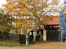
- Restored half-timbered house in Friedersdorf
schools
In Markersdorf there is a primary school with all-day courses that emerged from the former Markersdorf secondary school in the 2006/2007 school year. The conversion from middle school to elementary school is in response to the declining student numbers in the community.
Personalities
Sons and daughters of the church
- Michael Wehlt (1619–1667), chronicler and parish clerk of Gersdorf
- Heinz Bielka (* 1929), biologist, born in the Gersdorf district
- Christfried Schmidt (* 1932), composer and arranger
- Gerd Antos (* 1949), Professor of German Linguistics
Other personalities
- Benjamin Ferdinand Herrmann (1757–1837), pastor in Markersdorf from 1804 to 1837.
- François Joseph Kirgener (1766-1813), was a French general de division.
- Jean Pierre Joseph Bruguière (1772-1813), was a French Général de division.
- Géraud Christophe Michel Duroc (1772–1813), was a French general de division, Napoleon's adjutant and one of his closest confidants.
traffic
The national highway 6 and the railway line Dresden-Görlitz run by the municipality. The federal motorway 4 runs north of it and can be reached via the Görlitz junction .
See also
literature
- Markersdorf and the surrounding area - local history contributions to the community of Markersdorf in the Lower Silesian Upper Lusatia District . Goerlitz 1996.
- From the Muskauer Heide to the Rotstein. Home book of the Lower Silesian Upper Lusatia District . Lusatia Verlag, Bautzen 2006, p. 362 f .
- Municipal administration Markersdorf (ed.): Markersdorf - Holtendorf am Weißen Schöps. Highlights from the past . Local history contributions to the community of Markersdorf in the Lower Silesian Oberlausitzkreis. 1997, p. 80 (taken from the local brochure, published on the occasion of the 650th anniversary of the locality in 1997).
Web links
- Markersdorf municipality
- Pictures from the community of Markersdorf
- Markersdorf in the Digital Historical Directory of Saxony
- Unofficial page Markersdorf.com
Individual evidence
- ↑ Population of the Free State of Saxony by municipalities on December 31, 2019 ( help on this ).
- ↑ Results of the 2019 municipal council elections
- ^ Markersdorf primary school - Markersdorf community. Retrieved August 21, 2018 .


