
Schöpstal
| coat of arms | Germany map | |
|---|---|---|
 Help on coat of arms |
Coordinates: 51 ° 11 ′ N , 14 ° 57 ′ E |
|
| Basic data | ||
| State : | Saxony | |
| County : | Goerlitz | |
| Administrative association: | White Schöps / Neisse | |
| Height : | 248 m above sea level NHN | |
| Area : | 29.73 km 2 | |
| Residents: | 2396 (Dec. 31, 2019) | |
| Population density : | 81 inhabitants per km 2 | |
| Postal code : | 02829 | |
| Area code : | 03581 | |
| License plate : | GR, LÖB, NOL, NY, WSW, ZI | |
| Community key : | 14 6 26 520 | |
| LOCODE : | DE ZGQ | |
| Community structure: | 3 parts of the community | |
| Address of the municipal administration: |
Am Schloss 11 OT Ebersbach 02829 Schöpstal |
|
| Website : | ||
| Mayor : | Bernd Kalkbrenner | |
| Location of the community Schöpstal in the district of Görlitz | ||
  |
||

Schöpstal ( Upper Sorbian Šepcowy Doł ) is a municipality in the district of Görlitz in the east of the Free State of Saxony . Schöpstal belongs to the administrative association Weißer Schöps / Neisse . It consists of the villages Ebersbach, Girbigsdorf, Kunnersdorf and Liebstein.
Geography and traffic
The municipality of Schöpstal is located in the eastern part of the district of Görlitz and borders the district town of Görlitz . The districts along the Weißen Schöps are classic Waldhufendörfer .
Schöpstal is cut in the northeast by the federal highway 115 and the federal highway 4 . The former railway line to the Königshain quarries , which had a train station in Ebersbach, has been converted into a cycle path. In the north-east, the Berlin – Görlitz railway line and the eastern end of Bundesstraße 6 touch the municipality.
The Weisse Schöps runs through the community from south to north, in a partly deeply cut river valley that narrows to less than 100 m between Ebersbach and Kunnersdorf and is enclosed by increasingly steep slopes. The agriculturally used areas on both sides of the Schöps have a heavy but fertile clay soil which, however, tends to become wet. For this reason, the agricultural cooperative in Ebersbach is one of the pioneering companies in ploughless tillage in Saxony. Hardly any remains of the original hoof division have survived after the move to a large block corridor . The Königshain Mountains rise near Liebstein in the west .
history
The district Girbigsdorf is first mentioned in 1282, Ebersbach 1285, Kunnersdorf 1319 and Liebstein 1330. The villages Girbigsdorf, Ebersbach and Kunnersdorf were created as Waldhufendörfer as early as the first half of the 13th century in the course of the German settlement in the east . Even before the settlement in the east there must have been a thin settlement on the Schöps, as the existence of Slavic or early German castle walls in Liebstein and Ebersbach shows. In addition, tithe income from the Wenceslas Church in Jauernick from Ebersbach and Kunnersdorf has been handed down. These could come from a time when the Jauernicker Großpfarrei looked after the entire surrounding area, and did not expire when the parish of Ebersbach or later its Kunnersdorf branch was established after the settlement of the places under German law. Only in Liebstein has the original form of the village and corridor of a round hamlet with a block corridor been preserved .
A stay of the then Ascanian sovereign Otto V in Ebersbach in 1285 and the not entirely credible report of Duke Johann von Görlitz's escape from angry citizens of the city to Ebersbach suggest that Ebersbach, like the nearby Königshain, was sovereign property and perhaps around 1200 belonged to the domain around Reichenbach.
As the first proven noble owners of Ebersbach, “Vraw Else Bischoffswerdyne and Hans, ir son zu Ebirspach” appear in the Görlitz Liber acticatorum in the first years of the 15th century . Their connection to the von Bischofswerde family in Görlitz, which was often documented as early as the 14th century, is unclear and could then be described as ministerial . In any case, those from Bischofswerde auf Ebersbach had a close relationship with the city of Görlitz. The named Hans von Bischofswerde was still captain of the Nikolaiviertel during the Hussite Wars. Even then and back in 1509 the family owned a house in Nikolaigasse. In 1528 two brothers from Bischofwerde are referred to as "some of Gorlitz Mitburgere" and they also occasionally married their daughters to Görlitz patrician sons .
Their manorial rule extended to Ebersbach and Kunnersdorf. Ebersbach they had due to inheritances two outworks in own economy , the "upper and nidern stone Stock" . In addition, they were court lords and patron saints of the Ebersbacher church and its Kunnersdorfer branch. From a local historical perspective, the conflicts are also of relevance, in which they in 1449 with the von Gersdorf auf Königshain around certain watercourses, in 1467 with their own pastor around the beer bar and the Kunnersdorfer branch and in 1511 with the city of Görlitz, which prevented them from importing foreign beers, were involved. In 1491, because of the murder of the Ebersbach pastor, the interdict was placed over the entire district.
In Girbigsdorf, the von Bischofswerde also owned a farm, whose pertinence included not only possessed people, but also the mill and a quarter of the court revenue as well as the district of Rosenfeld (Ober-Girbigsdorf). Otherwise, the Görlitzer Hospital in Girbigsdorf had already owned the Görlitzer Hospital at the end of the 13th century, and Görlitzer patricians had also owned it from the middle of the 15th century. In 1544 a bridge triggered a dispute with Görlitz.
In 1584 the von Bischofswerde sold Ebersbach to Job von Salza . The Girbigsdorf property remained as a dowry until her death in the possession of Katharina Plaunitz, a born von Bischofswerde, and in 1608 went to her nephew Siegmund von Hermsdorf. In 1613, Job von Salza founded a diaconate to look after the Kunnersdorf chapel.
During the Hussite Wars , the Thirty Years 'War , the Seven Years' War and the Liberation War , the places of the Schöpstal were affected.
Between 1952 and 1955, agricultural production cooperatives were founded in Girbigsdorf, Ebersbach and Kunnersdorf ( Liebstein was incorporated from Königshain to Kunnersdorf in 1950) .
On January 1, 1994, the communities of Ebersbach, Girbigsdorf and Kunnersdorf merged to form the new community of Schöpstal. On January 1, 1999, the moat settlement was separated from Schöpstal and incorporated into Görlitz.
politics
Since the municipal council election on May 25, 2014 , the 14 seats of the municipal council have been distributed among the individual groups as follows:
- Free voters Schöpstal (FUW): 6 seats
- "Citizens for Schöpstal" (BfS): 4 seats
- CDU : 2 seats
- FDP : 1 seat
- LEFT : 1 seat
Mayor Bernd Kalkbrenner was confirmed in office in June 2015 with 95.0% of the votes.
Attractions
The cultural monuments are recorded in the list of cultural monuments in Schöpstal .
- Castle with castle park and pond in Girbigsdorf
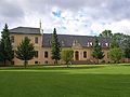
- Green meadow with park and bowling alley in Girbigsdorf
- Ebersbach moated castle and castle grounds
- Parish Church of St. Barbara in Ebersbach . The two-aisled church, first documented in 1346, was built in its present form in the 15th century by a Görlitz construction company . It is clearly based on urban forms of church building. Later a renaissance tower and a chapel were added, which later served as the Salza family crypt. Also noteworthy are 3 tombstones of von Bischoffswerde, von Salza and von Redern.
- Kesselberg, Ebersbach I castle wall . The hilltop castle on the steep right edge of the valley of the Schöps is very well preserved. So far, no excavation results are available about the ring wall, which is referred to as Slavic. The other two castle walls in the Schöpstaler corridor have not been preserved or have been badly damaged.
- Castle and park in Kunnersdorf
- Castle tomb in Kunnersdorf (noble family Oppeln-Bronikowski )
- The Way of St. James in the Görlitz – Weißenberg – Bautzen section leads via Ebersbach and Liebstein.
- Box oak with a chest height of 7.56 m (2016).
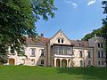
Girbigsdorf Castle

Ebersbach moated castle
Kunnersdorf Castle


literature
- Walter von Boetticher : The von Bischofswerde from Görlitz and Ebersbach. in: Neues Lausitzisches Magazin 86 (1910), pp. 81-102.
- Hermann Knothe : History of the Upper Lusatian nobility and its goods. Leipzig 1879.
- Christian Adolf Pescheck : Literary basis for the history of the Upper Lusatian villages (II) in: Neues Lausitzisches Magazin 35 (1859), p. 137–164, here p. 139f. (opens up the older literature and handwritten chronicles)
Individual evidence
- ↑ Population of the Free State of Saxony by municipalities on December 31, 2019 ( help on this ).
- ^ Art. Girbigsdorf, Ebersbach, Kunnersdorf and Liebstein in the digital historical place directory of Saxony
- ^ Jasper von Richthofen: The state crown near Görlitz. An important Slavic fortification in eastern Upper Lusatia. in: Work and research reports on Saxon soil monument preservation 45 (2003), pp. 263-300, here pp. 296, 298.
- ↑ Joachim Huth : The Slavic pre-settlement of the Eigenes circle. In: Lětopis (B) 9. Bautzen 1962, p. 37f
- ^ Richard Jecht : History of the city of Görlitz. Görlitz 1926, p. 40.
- ^ Max Jänecke: The Upper Lusatian rule. Diss. Mss. Leipzig 1923, p. 132f.
- ^ Walter von Boetticher : The von Bischofswerde from Görlitz and Ebersbach. in: Neues Lausitzisches Magazin 86 (1910), pp. 81-102.
- ↑ Görlitzer Rathsannalen. Scriptores Rerum Lusaticarum NF 2, Görlitz 1841, p. 356.
- ^ Walter von Boetticher: The von Bischofswerde from Görlitz and Ebersbach. in: Neues Lausitzisches Magazin 86 (1910), pp. 81-102.
- ↑ Christian Gottlieb Buyer : Abriß der Oberlausitzische Geschichte , Vol. IV, Görlitz 1802, S. 144f
- ^ Görlitz council bills. Codex Diplomaticus Lusatiae Superioris II.2, p. 324, line 18 reports without further details that Hussites from Silesia, past Görlitz, moved on to Ebersbach. Only later chroniclers report of destruction.
- ↑ Results of the 2014 municipal council elections
- ^ Hans Lutsch: Directory of the Art Monuments of the Province of Silesia, Vol. 3, The District of Liegnitz , Breslau 1891, p. 732f. Marius Winzeler: Bohemian influences in architecture and art of Upper Lusatia in the Middle Ages. in: Lars-Arne Dannenberg (Ed.): Böhmen - Oberlausitz - Czech Republic, aspects of a neighborhood , Görlitz 2006, pp. 55–70, here p. 63.
- ^ Jasper von Richthofen: The state crown near Görlitz. An important Slavic fortification in eastern Upper Lusatia , in: Arbeits- und Forschungsberichte zur Sächsische Bodendenkmalpflege 45 (2003), pp. 263-300, here p. 296.
- ^ Entry in the directory of monumental oaks . Retrieved January 10, 2017
Web links
- Website of the community of Schöpstal
- Municipality of Schöpstal Website of the administrative association

Bad Muskau (Mužakow) | Beiersdorf | Bernstadt ad Eigen | Bertsdorf-Hörnitz | Boxberg / OL (Hamor) | Dürrhennersdorf | Ebersbach-Neugersdorf | Gablenz (Jabłońc) | Goerlitz | Groß Düben (Dźěwin) | Großschönau | Großschweidnitz | Chickens | Hainewalde | Herrnhut | Hohendubrau (Wysoka Dubrawa) | Horka | Jonsdorf | Kodersdorf | Königshain | Kottmar | Krauschwitz (Krušwica) | Kreba-Neudorf (Chrjebja-Nowa Wjes) | Lawalde | Leutersdorf | Löbau | Markersdorf | Mittelherwigsdorf | Mücka (Mikow) | Neißeaue | Neusalza-Spremberg | Niesky | Oderwitz | Olbersdorf | Oppach | Ostritz | Oybin | Quitzdorf am See | Reichenbach / OL | Rietschen (Rěčicy) | Rosenbach | Rothenburg / OL | Loop (slepo) | Schönau-Berzdorf ad Eigen | Schönbach | Schöpstal | Seifhennersdorf | Trebendorf (Trjebin) | Vierkirchen | Forest hooves | White chisel (Wuskidź) | White water (Běła Woda) | Zittau