
Kodersdorf
| coat of arms | Germany map | |
|---|---|---|

|
Coordinates: 51 ° 14 ' N , 14 ° 53' E |
|
| Basic data | ||
| State : | Saxony | |
| County : | Goerlitz | |
| Administrative association: | White Schöps / Neisse | |
| Height : | 328 m above sea level NHN | |
| Area : | 42.54 km 2 | |
| Residents: | 2422 (Dec. 31, 2019) | |
| Population density : | 57 inhabitants per km 2 | |
| Postal code : | 02923 | |
| Area code : | 035825 | |
| License plate : | GR, LÖB, NOL, NY, WSW, ZI | |
| Community key : | 14 6 26 230 | |
| LOCODE : | DE KOD | |
| Community structure: | 4 districts | |
| Address of the municipal administration: |
Street of the unit 79 02923 Kodersdorf |
|
| Website : | ||
| Mayor : | René Schöne ( CDU ) | |
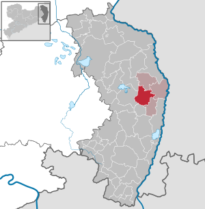
| Location of the municipality of Kodersdorf in the district of Görlitz | ||
  |
||

Kodersdorf ( Upper Sorbian Kodrecy ) is a Saxon municipality in the district of Görlitz , which belongs to the administrative association Weißer Schöps / Neisse .
geography
The municipality of Kodersdorf is located in the central part of the district, around 11 km northwest of the district town of Görlitz and 10 km south of Niesky on the edge of the Königshain Mountains and the Upper Lusatian heath and pond landscape in the White Schöps valley .
Community structure
The districts belong to the municipality
- Kodersdorf (1636 inhabitants)
- Kodersdorf train station (250 inhabitants)
- Särichen (340 inhabitants)
- Wiesa (331 inhabitants)
The villages of Rengersdorf and Torga , which were incorporated in 1938, have risen up in the Kodersdorf district .
history

The district Kodersdorf was first mentioned in 1402 as Kosmirsdorf . The local form as Waldhufendorf indicates that it is a German settlement in the second phase of the German Ostsiedlung . From an ecclesiastical point of view, Kodersdorf has been a parish after Nieder-Rengersdorf.
In the course of the Peace of Prague in 1635 , the Electorate of Saxony was able to secure the margravate Upper Lusatia and Lower Lusatia . The Kingdom of Saxony , which had meanwhile become a kingdom, had to cede most of the Lausitz to Prussia in 1815, whereby Kodersdorf and the surrounding towns came to the province of Silesia and in 1816 were incorporated into the Rothenburg district (Ob. Laus.) .
After the village had been dominated by agriculture for centuries, strong industrialization began towards the end of the 19th century. The construction of the Berlin-Görlitz Railway and raw material deposits such as wood and high-quality clay were the basis for a large brickworks and construction company to be built in Kodersdorf along with its own sawmill.
After the Second World War, the industrial operations were quickly rebuilt, so that the brickworks were able to employ 620 workers again in 1946, compared with 760 in the mid-twenties. Another change took place during the fall of the century , when industrial companies had to lay off many workers.
politics
Since the municipal council election on May 26, 2019 , the 12 seats of the municipal council have been distributed among the individual groups as follows:
- Christian Democratic Union of Germany (CDU): 7 seats
- Voters' association “Our Kodersdorf” (WVUK): 4 seats
- vacant as not enough applicants were candidates: 1 seat
In the municipal council election on May 25, 2014 , all 12 municipal council seats went to the CDU candidates (99.4% of the votes, the remaining votes received 4 individual proposals). The turnout was 52.8 percent.
Attractions

- Evangelical church, built as a Romanesque hall church in the first half of the 13th century
- Ober-Rengersdorf Castle
- Municipal Office
- Koenigshain Mountains
The cultural monuments are recorded in the list of cultural monuments in Kodersdorf .
Economy and Infrastructure

A large wood processing company has settled in the municipality's industrial park, which was part of the Austrian Klausner Group as Klausner Holz Sachsen from 2004 to 2015 and was sold by it to Holzindustrie Schweighofer . Around 700,000 cubic meters of sawn coniferous timber can be technically dried in the plant every year.
Transport links
The national highway 115 and the Federal Highway 4 lead by the municipality in which the highway with the 3.3 kilometer tunnel Königshainer mountain passes under the Königshainer mountains.
Kodersdorf is located with a train station on the Berlin – Görlitz railway line . In 2006, a four-kilometer-long siding to the sawmill in the industrial park was built on the open track , on which a freight train with raw wood or wood products runs every working day. As a result, 20,000 truck arrivals and departures could be avoided each year.
Sources and further reading
literature
- From the Muskauer Heide to the Rotstein. Home book of the Lower Silesian Upper Lusatia District . Lusatia Verlag, Bautzen 2006, p. 334 f .
Footnotes
- ↑ Population of the Free State of Saxony by municipalities on December 31, 2019 ( help on this ).
- ↑ Small-scale municipality sheet of the Free State of Saxony. Kodersdorf. 2011 Census (PDF document)
- ↑ Results of the 2019 municipal council elections
- ↑ Results of the 2014 municipal council elections
- ↑ Schweighofer completes purchase of Kodersdorf. European Economic Service, October 7, 2015, accessed October 25, 2016 .
- ↑ Three press reports on the inauguration of the sidings ( memento from 23 August 2006 in the Internet Archive )
Web links
- Kodersdorf community
- Kodersdorf in the Digital Historical Directory of Saxony
- Municipality of Kodersdorf Website of the administrative association Weißer Schöps-Neisse

Bad Muskau (Mužakow) | Beiersdorf | Bernstadt ad Eigen | Bertsdorf-Hörnitz | Boxberg / OL (Hamor) | Dürrhennersdorf | Ebersbach-Neugersdorf | Gablenz (Jabłońc) | Goerlitz | Groß Düben (Dźěwin) | Großschönau | Großschweidnitz | Chickens | Hainewalde | Herrnhut | Hohendubrau (Wysoka Dubrawa) | Horka | Jonsdorf | Kodersdorf | Königshain | Kottmar | Krauschwitz (Krušwica) | Kreba-Neudorf (Chrjebja-Nowa Wjes) | Lawalde | Leutersdorf | Löbau | Markersdorf | Mittelherwigsdorf | Mücka (Mikow) | Neißeaue | Neusalza-Spremberg | Niesky | Oderwitz | Olbersdorf | Oppach | Ostritz | Oybin | Quitzdorf am See | Reichenbach / OL | Rietschen (Rěčicy) | Rosenbach | Rothenburg / OL | Loop (slepo) | Schönau-Berzdorf ad Eigen | Schönbach | Schöpstal | Seifhennersdorf | Trebendorf (Trjebin) | Vierkirchen | Forest hooves | White chisel (Wuskidź) | White water (Běła Woda) | Zittau