Province of Silesia
| flag | coat of arms |
|---|---|

|

|
| Situation in Prussia | |

|
|
| Consist | 1815-1919, 1938-1941 |
| Provincial capital | Wroclaw |
| surface | 40,335 km² (1910) 37,013 km² (1939) |
| Residents | 4,868,764 (1939) |
| Population density | 132 inhabitants / km² (1939) |
| administration | 3 administrative districts |
| License Plate | IK |
| Arose from | Silesia |
| Incorporated into | Province of Lower Silesia , Province of Upper Silesia |
| Today part of | v. a. Poland ; Saxony , Czech Republic |
| map | |
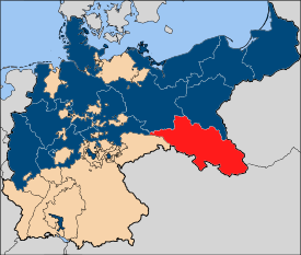
The Prussian Province of Silesia (also unofficially known as Prussian Silesia ) was a province in the southeast of the state of Prussia . Most of the historical region of Silesia belonged to it . The capital was Breslau . The province of Silesia existed from 1815 to 1919 and again from 1938 to 1941. In the years from 1919 to 1938 and from 1941 it was divided into the provinces of Lower Silesia and Upper Silesia .
history
Most of the Duchy of Silesia, along with the County of Glatz , was made a province of the Prussian state by the Prussian King Friedrich II in 1742 after the First Silesian War as a result of the Peace of Berlin . After Prussia had reorganized all of its territories as provinces in a new form after the Congress of Vienna in 1815, northern Upper Lusatia around Görlitz was added to the province of Silesia in 1816. The historical sub-landscape of Upper Silesia formed the administrative district of Opole. Lower Silesia was divided into the administrative districts of Breslau and Liegnitz , and briefly also in the administrative district of Reichenbach .
As part of Prussia, the province belonged to the German Confederation until 1866 and to the German Empire from 1871 . In the Reichstag elections , the predominantly Catholic Upper Silesians voted for the majority of the Center Party, while the Lower Silesians initially mainly voted for the “German Freethinkers”, later increasingly the SPD . With industrialization, Upper Silesia with its coal mines became an important industrial area of the empire.
When the Second Polish Republic came into being after the First World War and made territorial claims to parts of the eastern Prussian provinces, the area was divided into the provinces of Lower and Upper Silesia in 1919 in order to give the many Slavic-speaking Upper Silesians more independence and to allow them to participate in the upcoming referendum To hold Upper Silesia for the Reich. As a result of the three Polish uprisings in Upper Silesia , parts of Upper Silesia ( Eastern Upper Silesia ) had to be ceded to Poland in 1922. The Hultschiner Ländchen went to Czechoslovakia as early as 1920 .
In 1938 the province was rebuilt for a short time. Territory annexed after the attack on Poland , which in the south-east extended well beyond the previous borders, was added in violation of international law at the end of 1939 .
Divided again in 1941, the area was almost entirely placed under the administration of Poland in 1945 as a result of the German defeat in World War II, and incorporated into the state. Here it is distributed today v. a. to the voivodeships of Silesia , Lower Silesia and Opole , as well as Lebus , Greater Poland and Lesser Poland . A small part remained with Germany and is distributed today within the Free State of Saxony between the districts of Bautzen and Görlitz .
Population development
| year | Residents |
|---|---|
| 1819 | 2,061,589 |
| 1846 | 3,065,809 |
| 1871 | 3,707,167 |
| 1880 | 4,007,925 |
| 1890 | 4,224,458 |
| 1900 | 4,668,857 |
| 1910 | 5,225,962 |
| 1939 | 4,868,764 |
Administrative division 1910
Wroclaw Governorate
City districts
- Wroclaw
- Brieg (since 1907)
- Schweidnitz
Counties and counties
- Wroclaw district
- Brzeg district
- Frankenstein district
- Circle of Glatz
- Groß Wartenberg district
- District of Guhrau
- District of Habelschwerdt
- Militsch district
- Münsterberg district
- Namslau district
- Neumarkt district
- Neurode district
- Nimptsch district
- District of Oels
- Ohlau district
- Reichenbach district
- Schweidnitz district
- Steinau district
- Circle chasing
- Striegau district
- Trebnitz district
- Waldenburg district
- District Wohlau
Liegnitz administrative district
City districts
Counties and counties
- Bolkenhain district
- Bunzlau district
- Freystadt district
- District of Glogau
- Goldberg-Haynau district
- Goerlitz district
- Grünberg district
- District of Hirschberg i. R.
- District of Hoyerswerda
- District of Jauer
- Landeshut district
- Lauban district
- District of Liegnitz
- Löwenberg district
- Lüben district
- District of Rothenburg (Ob. Laus.)
- Sagan County
- District of Schönau
- Sprottau district
Opole administrative district
City districts
Counties and counties
- Beuthen district
- District of Cosel
- Falkenberg district
- Groß Strehlitz district
- Grottkau district
- District of Hindenburg OS
- Katowice County
- Kreuzburg district
- District of Leobschütz
- Lublinitz district
- Neisse district
- Neustadt district
- Opole district
- District of Pless
- Ratibor district
- Rosenberg district
- Rybnik district
- Tarnowitz district
- Tost-Gleiwitz district
Development of the ethnolinguistic structure
| year | Polish | German | ||
|---|---|---|---|---|
| absolutely | percentage | absolutely | percentage | |
| 1819 | 377.100 | 67.2% | 162,600 | 29.0% |
| 1828 | 418,437 | 255.383 | ||
| 1831 | 456.348 | 257.852 | ||
| 1837 | 495,362 | 290.168 | ||
| 1840 | 525.395 | 330.099 | ||
| 1843 | 540.402 | 348.094 | ||
| 1846 | 568,582 | 364.175 | ||
| 1852 | 584.293 | 363,990 | ||
| 1858 | 612,849 | 406,950 | ||
| 1861 | 665.865 | 409.218 | ||
| 1867 | 742.153 | 457,545 | ||
| 1890 | 918.728 | 58.2% | 566,523 | 35.9% |
| 1900 | 1., 048.230 | 56.1% | 684.397 | 36.6% |
| 1905 | 1,158,805 | 56.9% | 757.200 | 37.2% |
| 1910 | 1,169,340 | 53.0% | 884.045 | 40.0% |
Chief President
- 1816–1820: Friedrich Theodor von Merckel
- 1824–1825: Moritz Haubold von Schönberg
- 1825: Hans von Bülow
- 1825–1845: Friedrich Theodor von Merckel
- 1845–1848: Wilhelm von Wedell
- 1848: Hans David Ludwig Yorck von Wartenburg
- 1848: Julius Pinder
- 1848–1868: Johann Eduard von Schleinitz
- 1869–1872: Eberhard zu Stolberg-Wernigerode
- 1873–1874: Ferdinand von Nordenflycht
- 1874–1877: Adolf von Arnim-Boitzenburg
- 1877–1879: Robert Viktor von Puttkamer
- 1879–1894: Otto Theodor von Seydewitz
- 1894–1903: Hermann von Hatzfeldt
- 1903–1909: Robert von Zedlitz-Trützschler
- 1910: Johann von Dallwitz
- 1910–1919: Hans Lauchlan von Guenther
- 1919: Felix Philipp
- 1919–1938: divided into the Province of Lower Silesia and the Province of Upper Silesia
- 1938–1941: Josef Wagner
See also
literature
- Joseph Partsch : Silesia: a regional study for the German people. T. 1., The whole country . 1896, Breslau, Ferdinand Hirt publishing house.
- Joseph Partsch: Silesia: a regional study for the German people. T. 2., Landscapes and Settlements . 1911, Breslau, Verlag Ferdinand Hirt.
- F. Leonardi (ed.): Earth description of the Prussian monarchy . Volume 3, Halle 1794, pp. 210-303.
- Hugo Weczerka (Hrsg.): Handbook of the historical places . Volume: Silesia (= Kröner's pocket edition . Volume 316). Kröner, Stuttgart 1977, ISBN 3-520-31601-3 .
- Hugo Weczerka: City and market foundations and city exits in Silesia 1450-1800. In: Journal for East Research . Vol. 23, 1974, pp. 193-260.
- Lucyna Harc et al .: Cuius regio? Ideological and Territorial Cohesion of the Historical Region of Silesia (c. 1000-2000) vol. 4., Region Divided: Times of Nation-States (1918-1945) . Wrocław, 2014, eBooki.com.pl ISBN 978-83-927132-8-9
- Paul Weber: The Poles in Upper Silesia: a statistical study . 1913, Julius Springer's bookstore in Berlin
- Robert Semple: Observations made on a tour from Hamburg through Berlin, Gorlitz, and Breslau, to Silberberg; and thence to Gottenburg , London 1814
- Johann Georg Knie : Alphabetical-statistical-topographical overview of all villages, spots, towns and other places of the royal family. Prussia. Province of Silesia, including the Margraviate of Upper Lusatia, which now belongs entirely to the province, and the County of Glatz; together with the attached evidence of the division of the country into the various branches of civil administration . Graß, Barth and Comp., Breslau 1830 ( e-copy ).
- Johann Georg Knie: Alphabetical-statistical-topographical overview of the villages, towns, cities and other places of the royal family. Prussia. Province of Silesia, along with the appended division of the country into the districts of the three royal governments, the principalities and districts contained therein, with details of the area, the central elevation above the sea surface, the inhabitants, buildings, the livestock, etc. 2nd edition, Breslau 1845 ( E-copy ).
- Helmut Bleiber, Walter Schmidt : Silesia on the way to civil society. Movements and protagonists of Silesian democracy around 1848 . First and second half volume, trafo verlag, Berlin 2007 (= Silesia. Silesia in the European reference field. Sources and research. Volume 6). ISBN 978-3-89626-639-2 and ISBN 978-3-89626-671-2 .
Web links
Individual evidence
- ^ Prussian Provinces 1910 , Gemeindeververzeichnis.de
- ↑ a b Statistical Yearbook for the German Reich 1939/40 (digitized version)
- ^ Peter Baumgart : Silesia as an independent province in the old Prussian state (1740-1806) . In Norbert Conrads (Hrsg.): German history in Eastern Europe. Silesia . Siedler, Berlin 2002, ISBN 978-3-88680-775-8 , p. 346
- ^ Statistisches Bureau zu Berlin (Ed.): Contributions to the statistics of the Prussian state . Duncker & Humblot, Berlin 1821, Silesia, p. 86 ( digitized version ).
- ↑ Royal Statistical Bureau (ed.): Mittheilungen des Statistisches Bureau's in Berlin, Volume 2 . Population of the districts. ( Digitized version ).
- ^ Michael Rademacher: German administrative history from the unification of the empire in 1871 to the reunification in 1990. p_schlesien.html. (Online material for the dissertation, Osnabrück 2006).
- ↑ Georg Hassel: Statistical outline of all European and the most distinguished non-European states, in terms of their development, size, population, financial and military constitution, presented in tabular form; First issue: Which represents the two great powers Austria and Prussia and the German Confederation ; Verlag des Geographisches Institut Weimar (1823), p. 34; (Total population in 1819: 561,203; Moravians: 12,000; Jews: 8,000 and Czechs: 1,600)
- ↑ a b c d e f g h i j Paul Weber: The Poles in Upper Silesia: a statistical study ; Julius Springer's publishing bookstore in Berlin (1913), pp. 8–9
- ^ A b c d Paul Weber: The Poles in Upper Silesia: a statistical study ; Julius Springer's publishing bookstore in Berlin (1913), p. 27


